
Hounslow is a large suburban district of West London, 10+3⁄4 miles west-southwest of Charing Cross. It is the administrative centre of the London Borough of Hounslow, and is identified in the London Plan as one of the 12 metropolitan centres in Greater London.
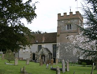
Harefield is a village in the London Borough of Hillingdon, England, 17 miles (27 km) northwest of Charing Cross near Greater London's boundary with Buckinghamshire to the west and Hertfordshire to the north. The population at the 2011 Census was 7,399. Harefield is the westernmost settlement in Greater London.
The London Borough of Ealing is a London borough in West London. It comprises seven major towns: Acton (W3), Ealing, Greenford (UB6), Hanwell (W7), Northolt (UB5), Perivale (UB6) and Southall. With a population of 367,100 inhabitants, it is the third most populous London borough.
Northolt is a town in West London, England, spread across both sides of the A40 trunk road. It is 11 miles (17.7 km) west-northwest of Charing Cross and is one of the seven major towns that make up the London Borough of Ealing. It had a population of 30,304 at the 2011 UK census.

Northwood is an affluent area in northwest London, England. It is located within the London Borough of Hillingdon on the border with Hertfordshire and 14.5 miles (23.3 km) from Charing Cross. Northwood was part of the ancient parish of Ruislip, Middlesex and has formed part of Greater London since 1965.

Ruislip is an area in the London Borough of Hillingdon in West London. Prior to 1965 it was in Middlesex. Ruislip lies 13.8 miles (22.2 km) west-north-west of Charing Cross, London.

Southall is a large suburban town in West London, England, part of the London Borough of Ealing and is one of its seven major towns. It is situated 10.7 miles (17.2 km) west of Charing Cross and had a population of 69,857 as of 2011. It is generally divided in three parts: the mostly residential area around Lady Margaret Road ; the main commercial centre at High Street and Southall Broadway ; and Old Southall/Southall Green to the south consisting of Southall railway station, industries and Norwood Green bounded by the M4.

Uxbridge is a suburban town in west London and the administrative headquarters of the London Borough of Hillingdon. Situated 15.4 miles (24.8 km) west-northwest of Charing Cross, it is one of the major metropolitan centres identified in the London Plan. Uxbridge formed part of the parish of Hillingdon in the county of Middlesex, and was a significant local commercial centre from an early time. As part of the suburban growth of London in the 20th century it expanded and increased in population, becoming a municipal borough in 1955, and has formed part of Greater London since 1965.

Yeading is a settlement in west London, forming part of the London Borough of Hillingdon, having been developed after the Second World War.

Yiewsley is a large suburban village in the London Borough of Hillingdon, England, 2 miles (3 km) south of Uxbridge, the borough's commercial and administrative centre. Yiewsley was a chapelry in the ancient parish of Hillingdon, Middlesex. The population of the ward was 12,979 at the 2011 Census.
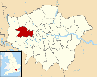
The London Borough of Hillingdon is the largest and westernmost borough in West London, England. It was formed in 1965 from the districts of Hayes and Harlington, Ruislip-Northwood, Uxbridge, and Yiewsley and West Drayton in the ceremonial county of Middlesex. Today, Hillingdon is home to Heathrow Airport and Brunel University, and is the second largest of the 32 London boroughs by area.
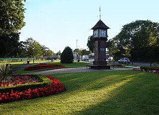
Hayes is a town in west London, historically situated within the county of Middlesex, and now part of the London Borough of Hillingdon. The town's population, including its localities Hayes End, Harlington and Yeading, was recorded as 83,564 in the 2011 census. It is situated 13 miles (21 km) west of Charing Cross, or 6.5 miles (10.5 km) east of Slough. The Grand Union Canal flows through the heart of Hayes, accompanied by the Great Western Main Line and significant industry, a town centre, residential areas and country parks.

Aston is an area of inner Birmingham, England. Located immediately to the north-east of Central Birmingham, Aston constitutes a ward within the metropolitan authority. It is approximately 1.5 miles from Birmingham City Centre.

West Drayton is a suburban town in the London Borough of Hillingdon. It was an ancient parish in the county of Middlesex and from 1929 was part of the Yiewsley and West Drayton Urban District, which became part of Greater London in 1965. The settlement is near the Colne Valley Regional Park and its centre lies 1.9 miles (3 km) north of Heathrow Airport.

RAF Uxbridge was a Royal Air Force (RAF) station in Uxbridge, within the London Borough of Hillingdon, occupying a 44.6-hectare (110-acre) site that originally belonged to the Hillingdon House estate. The British Government purchased the estate in 1915, three years before the founding of the RAF. Until the outbreak of the Second World War in 1939, the station was open to the public.

Stockley Park is a business estate and public country park located between Hayes, Yiewsley and West Drayton in the London Borough of Hillingdon. In August 2020 it was listed in the Register of Historic Parks and Gardens of Special Historic Interest in England as Grade II.
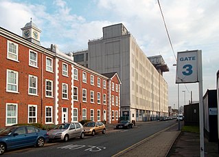
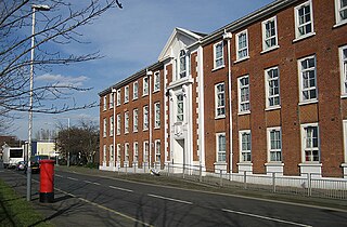
The Old Vinyl Factory is a complex of buildings formerly owned by the British music company EMI in Hayes, within the London Borough of Hillingdon. The site was originally purchased by Gramophone and Typewriter Ltd and the buildings were designed by Wallis, Gilbert and Partners in the early 20th century.

Lake Farm Country Park is an expanse of green belt land approximately 60 acres in size fringed by trees and the Grand Union Canal, situated in the south of Hayes in the London Borough of Hillingdon. Its formal status as a country park dates back to September 2002.
