Related Research Articles

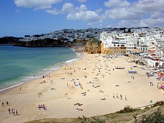
The Algarve is the southernmost NUTS II region of continental Portugal. It has an area of 4,997 km2 (1,929 sq mi) with 467,495 permanent inhabitants and incorporates 16 municipalities.

The 1755 Lisbon earthquake, also known as the Great Lisbon earthquake, impacted Portugal, the Iberian Peninsula, and Northwest Africa on the morning of Saturday, 1 November, Feast of All Saints, at around 09:40 local time. In combination with subsequent fires and a tsunami, the earthquake almost completely destroyed Lisbon and adjoining areas. Seismologists estimate the Lisbon earthquake had a magnitude of 7.7 or greater on the moment magnitude scale, with its epicenter in the Atlantic Ocean about 200 km west-southwest of Cape St. Vincent, a cape in Algarve region, and about 290 km southwest of Lisbon.

Lagos is a city and municipality at the mouth of Bensafrim River and along the Atlantic Ocean, in the Barlavento region of the Algarve, in southern Portugal. The population of the municipality in 2011 was 31,049, in an area of 212.99 km2. The city of Lagos proper has a population of approximately 22,000. Typically, these numbers increase during the summer months, with the influx of visiting tourists and seasonal residents. While the majority of the population lives along the coast and works in tourism and services, the inland region is sparsely inhabited, with the majority of the people working in agriculture and forestry.

Faro is a municipality, the southernmost city and capital of the district of the same name, in the Algarve region of southern Portugal. With an estimated population of 60,995 inhabitants in 2019, the municipality covers an area of about 202.57 km2 (78.21 sq mi).

The Castle of Salir is an Almohad fortress, located in the civil parish of the same name, 16 kilometres from the municipality seat of Loulé in the Portuguese Algarve.

Tavira is a Portuguese town and municipality, capital of the Costa do Acantilado, situated in the east of the Algarve on the south coast of Portugal. It is 28 kilometres east of Faro and 75 kilometres west of Huelva across the river Guadiana into Spain. The Gilão River meets the Atlantic Ocean in Tavira. The population in 2011 was 26,167, in an area of 606.97 km2. Tavira is the Portuguese representative community for the inscription of the Mediterranean Diet as a Intangible Cultural Heritage of Humanity of UNESCO.

Olhão, officially known as Olhão da Restauração, is a city and municipality in the Algarve region of southern Portugal. The population of the municipality in 2011 was 45,396, in an area of 130.86 km2 (50.53 sq mi). Located near the regional capital Faro and forming a single urban agglomeration, it is a fishing port and tourist center. Along with Faro, Loulé and Tavira, Olhão forms a conurbation from the eastern and central Algarve.

Loulé is a city and municipality in the region of Algarve, district of Faro, Portugal. In 2011, the population of the entire municipality was 70,622 inhabitants, in an area of approximately 763.67 square kilometres (294.85 sq mi). The municipality has two principal cities: Loulé and Quarteira.

Vila Real de Santo António is a city, civil parish, and municipality in the Algarve, Portugal. The population in 2011 was 19,156, in an area of 61.25 km2. It is one of the few municipalities in Portugal without territorial continuity: its territory comprises two parts, with the municipal seat located in the eastern part. Vila Real de Santo António was founded after the 1755 Lisbon earthquake, and largely expanded in 1774 using the same architectural and construction techniques employed in the reconstruction of Lisbon after the disaster.

Balsa was a Roman coastal town in the province of Lusitania, Conventus Pacensis.

The Castle of Aljezur is a medieval castle founded in the parish of Aljezur, in the municipality of the same name overlooking the Aljezur River. Excavations in the castle have discovered that the location was occupied during the Bronze and Iron Ages, while the parade grounds, habitational structures, and two silos date to the 12th and 13th centuries.
Albufeira is a city and municipality of Faro District in the Algarve region of southern Portugal. The population in 2021 was 44,158, in an area of 140.66 square kilometres. The city proper had a population of 28,645 in 2021. It is 250 kilometres (160 mi) from Lisbon, close to Paderne Castle. Lagoa is 30 kilometres (19 mi) to the west, and Faro 45 kilometres (28 mi) to the southeast. A tourist destination due to its coastal conditions, Albufeira's population expands to around 300,000 in the summer and at Christmas and New Year owing to the number of hotels that includes marina facilities, golf courses, restaurants and bars.

The Roman Ruins of Cerro da Vila are the remnants of a historical villa in the Algarve region of southern Portugal. Its vestiges lie in the vicinity of the resort and marina of Vilamoura, in the civil parish of Quarteira, municipality of Loulé Municipality.

The Castle of Tavira is a medieval castle located in the parish of Santiago, Tavira municipality, Faro district of Portugal. In a dominant position over the mouth of the river Gilão, the settlement has developed as an important sea port since antiquity, with its predecessors dating back to the 8th century BC, passing through the hands of Phoenicians, Greeks, Celts, Carthaginians, Romans, Moors and the Portuguese crown.
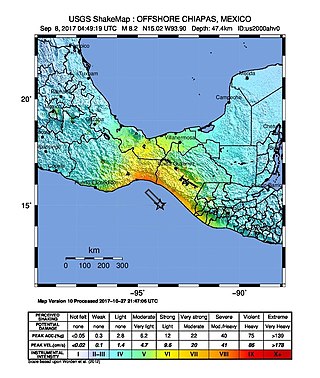
The 2017 Chiapas earthquake struck at 23:49 CDT on 7 September in the Gulf of Tehuantepec off the southern coast of Mexico near the state of Chiapas, approximately 87 kilometres (54 mi) southwest of Pijijiapan, with a Mercalli intensity of IX (Violent). The moment magnitude was estimated to be Mw8.2.
A moment magnitude Mw 7.0 or 7.1 earthquake occurred near the city of Acapulco in the Mexican state of Guerrero at 20:47 local time on 7 September with an estimated intensity of VIII (Severe) on the MMI scale. The earthquake killed 13 people and injured at least 23 others. At least 1.6 million people in Mexico were affected by the earthquake which resulted in localized severe damage. The earthquake occurred on the anniversary of the 2017 Chiapas earthquake which measured Mw 8.2. It was also the largest earthquake in Mexico since the 2020 Oaxaca earthquake.
The 1816 North Atlantic earthquake occurred on 2 February somewhere between the Azores Islands and Lisbon, Portugal. The estimated moment magnitude 8.3–8.9 earthquake had an epicenter offshore in the Atlantic Ocean, and was felt in Lisbon at 00:40 local time. Little is known about the quake, but it is believed to be one of the largest to have struck the Atlantic.

On 19 September 2022, a moment magnitude 7.6-7.7 earthquake struck between the Mexican states of Michoacán and Colima at 13:05:06 local time. The earthquake had a depth of 26.9 km (16.7 mi), resulting in a maximum intensity of VIII (Severe) on the Modified Mercalli intensity scale. The USGS reported the epicentre was 35 km (22 mi) southwest of the town of Aquila. Two people were killed and at least 35 others were injured across several states. A magnitude 6.8 aftershock struck on 22 September, causing three more deaths.
References
- 1 2 Chester, David K; Chester, Olivia K (December 2010). "The impact of eighteenth century earthquakes on the Algarve region, southern Portugal: The impact of eighteenth century earthquakes on the Algarve region". Geographical Journal. 176 (4): 350–370. doi:10.1111/j.1475-4959.2010.00367.x.
- ↑ "3 Major Iberian Earthquakes Highlight European Risk". AIRWorldwide. Retrieved 2023-02-07.
- ↑ Sismos em Portugal: estarão os edifícios preparados? (Visão) https://visao.sapo.pt/imobiliario/2021-05-04-sismos-em-portugal-estarao-os-edificios-preparados/
- ↑ Baptista, M. A.; Miranda, J. M.; Lopes, F. C.; Luis, J. F. (2007). "The source of the 1722 Algarve earthquake: evidence from MCS and Tsunami data". Journal of Seismology. 11 (4): 371–380. Bibcode:2007JSeis..11..371B. doi:10.1007/s10950-007-9058-y. hdl: 10316/7608 . S2CID 39872605.
- ↑ Andrade, C.; Freitas, M. C.; Oliveira, M. A.; Costa, P. J. (2016). "On the sedimentological and historical evidences of seismic-triggered tsunamis on the Algarve coast of Portugal". In Duarte, J. C.; Schellart, W. P. (eds.). Plate boundaries and natural Hazards. John Wiley & Sons. pp. 219–238.