1755 Cape Ann earthquake

Last updated

1755 Cape Ann earthquake
Relief map of USA Massachusetts.png
Bullseye1.png
Red pog.svg
Cape Ann
USGS-ANSS ComCat
Local dateNovember 18, 1755 (1755-11-18)
Local time04:30
Magnitude5.9 Mw [1]
Epicenter 42°42′N70°12′W / 42.7°N 70.2°W / 42.7; -70.2
Areas affected British America, Province of Massachusetts Bay
Max. intensity VIII (Severe)

The 1755 Cape Ann earthquake took place off the coast of the British Province of Massachusetts Bay (present-day Massachusetts) on November 18. At between 6.0 and 6.3 on the Richter scale, it remains the largest earthquake in the history of Massachusetts. No one was killed, but it damaged hundreds of buildings in Boston and was felt as far north as Nova Scotia and as far south as South Carolina. [2] Sailors on a ship more than 200 miles (320 km) offshore felt the quake, and mistook it at first for their ship running aground. Many residents of Boston and the surrounding areas attributed the quake to God, and it occasioned a brief increase in religious fervor in the city. Modern studies estimate that if a similar quake shook Boston today, it would result in as much as $5 billion in damage and hundreds of deaths. [3] Some discussion has revolved around the idea that this may have been a remotely triggered event from the 1755 Lisbon earthquake or its aftershocks.

Contents

Epicenter

The earthquake took place on November 18, 1755, at approximately 4:30 AM local time. Future President of the United States John Adams, then staying at his father's house in Braintree, Massachusetts, was awakened by the quake, which impressed him so much that he began a diary that night. He wrote that the quake "continued near four minutes" and that "[t]he house seemed to rock and reel and crack as if it would fall in ruins about us." [4] Its epicenter is believed to have been offshore, approximately 24 miles (39 km) east of Cape Ann. [3] The quake was felt as far north as Halifax, Nova Scotia, south to the Chesapeake Bay and South Carolina, and from Lake George and Lake Champlain in the northwest to a ship 200 miles (320 km) off the east coast. [5] [6] Sailors on the ship reported that the quake was so strong, they had feared that they had run aground. [5] The region experienced several aftershocks, the first of which was a little more than an hour after the quake. Most of these aftershocks could not be felt in Boston, affecting only the northeastern coast of the colony. [6]

Modern research has estimated that the quake was between 6.0 and 6.3 on the Richter scale, and the United States Geological Survey lists it as the largest earthquake in the history of Massachusetts. [6] Scientists are unclear on the causes of this and other quakes in the northeastern United States. There are a number of old faults in the region, but none of them is known still to be active. [3] It is possible that the Cape Ann earthquake may have been remotely triggered by a larger earthquake in Lisbon, Portugal, a few weeks prior, although there is not enough evidence to prove that they are linked. [7]

Damage

An 18th-century woodcut taken from a religious tract showing the effects of the Cape Ann earthquake Cape Ann earthquake.jpg
An 18th-century woodcut taken from a religious tract showing the effects of the Cape Ann earthquake

Boston and Cape Ann were the most heavily damaged. In Boston, damage was concentrated in areas of infill near the harbor; infill is less sturdy in earthquakes than solid land. From 1,300 to 1,600 chimneys in the city were damaged in some way, the gable ends of some houses collapsed, and a number of roofs were damaged by falling chimneys. [5] Stone chimneys and buildings were damaged in Falmouth (present-day Portland, Maine), Springfield, Massachusetts, and New Haven, Connecticut, as well. Some church steeples in Boston were damaged, ending up tilted from vertical. [3] [6] Stone fencing in rural areas was damaged. Observers also reported that several springs dried up, new ones were created, and cracks appeared in the ground near Scituate, Lancaster, and Pembroke. In this last town, observers noted water and fine sand coming from the crack. [5] Non-structural damage was minor; residents reported damage to china and glassware, and a distiller lost some of his product after a cistern was damaged. [6] The Cape Ann earthquake may also have created the first recorded tsunami in U.S. history. Observers in the Leeward Islands nearly 1,000 miles (1,600 km) south of Cape Ann, reported a receding of water followed by a large wave that lifted several boats ashore and left fish floundering on the beach. [8]

Legacy

An aerial view of Back Bay in Boston, which could suffer serious damage if another quake like the 1755 Cape Ann earthquake were to occur Boston Back Bay.jpg
An aerial view of Back Bay in Boston, which could suffer serious damage if another quake like the 1755 Cape Ann earthquake were to occur

Many Massachusetts residents of the time perceived the quake as punishment from God for immoral behavior. [8] In the days after the earthquake, special prayer services were held and civic authorities declared fast days. A number of sermons and other writings were published as a consequence, including Jeremiah Newland's Verses Occasioned by the Earthquakes in the Month of November, 1755 and Thomas Prince's Earthquakes the Works of God and Tokens of his Just Displeasure. Well before 1755, the new rational materialist ideas promulgated by Enlightenment scientists had begun to heavily influence the better-educated citizens of colonial America; therefore not all explanations of the event were theological. John Winthrop, a Harvard professor, proposed an alternate explanation having to do with heat and chemical vapors inside the surface of the earth. [6] John Adams, in comments in the margins of Winthrop’s Lecture on Earthquakes wrote:

I am not able to satisfy myself, whether the very general if not universal apprehension that Thunder, Earthquakes, Pestilence, Famine &c. are designed merely as Punishments of sins and Warnings to forsake, is natural to Mankind, or whether it was artfully propagated, or whether it was derived from Revelation. An Imagination that those Things are of no Use in Nature but to punish and alarm and arouse sinners, could not be derived from real Revelation, because it is far from being true, tho few Persons can be persuaded to think so. [9]

Since the 1755 earthquake, Boston and its surrounding towns have become a major metropolitan area. Much new construction has been built on infill, especially in the Back Bay area, which may be prone to greater shaking and to compaction of the sand and gravel used as fill. Many older buildings in the Boston area are built from stone and brick, and are likely to collapse completely during a major earthquake. Given this, modern observers have expressed concern about the effects of another quake in such a major city. A 1990 study by the Massachusetts Emergency Management Agency estimated potential financial losses at between $4 billion and $5 billion, and potential loss of life in the hundreds. [3] As a consequence, the state has updated building codes and zoning laws to require that new construction and additions in vulnerable areas be built to resist earthquakes. [3]

See also

Related Research Articles

<span class="mw-page-title-main">1811–1812 New Madrid earthquakes</span> Series of earthquakes during 1811-1812 impacting on Missouri USA

The 1811–1812 New Madrid earthquakes were a series of intense intraplate earthquakes beginning with an initial earthquake of moment magnitude 7.2–8.2 on December 16, 1811, followed by a moment magnitude 7.4 aftershock on the same day. Two additional earthquakes of similar magnitude followed in January and February 1812. They remain the most powerful earthquakes to hit the contiguous United States east of the Rocky Mountains in recorded history. The earthquakes, as well as the seismic zone of their occurrence, were named for the Mississippi River town of New Madrid, then part of the Louisiana Territory and now within the U.S. state of Missouri.

<span class="mw-page-title-main">John Winthrop (educator)</span> American mathematician, physicist and astronomer (1714–1779)

John Winthrop was an American mathematician, physicist and astronomer. He was the 2nd Hollis Professor of Mathematics and Natural Philosophy in Harvard College.

<span class="mw-page-title-main">2005 Fukuoka earthquake</span> Earthquake in Japan

The Fukuoka earthquake struck Fukuoka Prefecture, Japan at 10:53 am JST on March 20, 2005, and lasted for approximately 1 minute. The Japan Meteorological Agency (JMA) measured it as peaking at a magnitude of 7.0, whereas the United States Geological Survey (USGS) reported a magnitude of 6.6. The quake occurred along a previously unknown fault in the Genkai Sea, North of Fukuoka city, and the residents of Genkai Island were forced to evacuate as houses collapsed and landslides occurred in places. Investigations subsequent to the earthquake determined that the new fault was most likely an extension of the known Kego fault that runs through the centre of the city.

<span class="mw-page-title-main">1993 Scotts Mills earthquake</span> Earthquake in Oregon

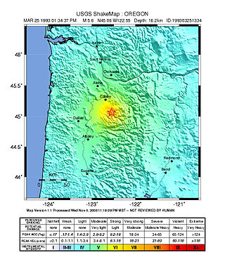
The 1993 Scotts Mills earthquake, also known as the "Spring break quake", occurred in the U.S. state of Oregon on March 25 at 5:34 AM Pacific Standard Time. With a moment magnitude of 5.6 and a maximum perceived intensity of VII on the Mercalli intensity scale, it was the largest earthquake in the Pacific Northwest since the Elk Lake and Goat Rocks earthquakes of 1981. Ground motion was widely felt in Oregon's Willamette Valley, the Portland metropolitan area, and as far north as the Puget Sound area near Seattle, Washington.

The 1952 Kern County earthquake occurred on July 21 in the southern San Joaquin Valley and measured 7.3 on the moment magnitude scale. The main shock occurred at 4:52 am Pacific Daylight Time, killed 12 people, injured hundreds more and caused an estimated $60 million in property damage. A small sector of damage near Bealville corresponded to a maximum Mercalli intensity of XI (Extreme), though this intensity rating was not representative of the majority of damage. The earthquake occurred on the White Wolf Fault near the community of Wheeler Ridge and was the strongest to occur in California since the 1906 San Francisco earthquake.

<span class="mw-page-title-main">1935 Timiskaming earthquake</span> Earthquake in Canada

The 1935 Temiskamingue earthquake occurred on November 1 with a moment magnitude of 6.1 and a maximum Mercalli intensity of VII. The event took place in the Western Quebec Seismic Zone in the Abitibi-Témiscamingue region of Quebec.

<span class="mw-page-title-main">1944 Cornwall–Massena earthquake</span> Earthquake near the New York–Ontario border

The 1944 Cornwall–Massena earthquake occurred on September 5 at 12:38:45 am EDT in Massena, New York. It registered 5.8 on the moment magnitude scale and had a maximum Mercalli intensity of VIII (Severe). This area is part of the Saint Lawrence River Valley and the seismically active zone known as the Saint Lawrence rift system. The earthquake is the largest known in New York's recorded history and was felt over great distances.

<span class="mw-page-title-main">1968 Illinois earthquake</span> Largest recorded earthquake in Illinois, US

The 1968 Illinois earthquake was the largest recorded earthquake in the U.S. Midwestern state of Illinois. Striking at 11:02 am on November 9, it measured 5.4 on the Richter scale. Although no fatalities occurred, the event caused considerable structural damage to buildings, including the toppling of chimneys and shaking in Chicago, the region's largest city. The earthquake was one of the most widely felt in U.S. history, largely affecting 23 states over an area of 580,000 sq mi (1,500,000 km2). In studying its cause, scientists discovered the Cottage Grove Fault in the Southern Illinois Basin.

<span class="mw-page-title-main">2011 Virginia earthquake</span> Earthquake in Virginia, U.S.

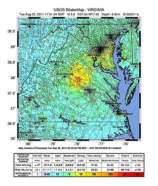
On August 23, 2011, a magnitude 5.8 earthquake hit the Piedmont region of the U.S. state of Virginia at 1:51:04 p.m. EDT. The epicenter, in Louisa County, was 38 mi (61 km) northwest of Richmond and 5 mi (8 km) south-southwest of the town of Mineral. It was an intraplate earthquake with a maximum perceived intensity of VIII (Severe) on the Mercalli intensity scale. Several aftershocks, ranging up to 4.5 Mw in magnitude, occurred after the main tremor.

<span class="mw-page-title-main">Geology of New Hampshire</span> Overview of the geology of the U.S. state of New Hampshire

The geology of New Hampshire is similar to that of the rest of New England in comprising a series of metamorphosed sedimentary and volcanic rocks of Late Proterozoic to Devonian age, intruded by many plutons and dikes ranging in age from Late Proterozoic to early Cretaceous. New Hampshire is known as "the Granite State", but less than half is underlain by granite; much of it is schist or gneiss, both of which are metamorphic rocks.

<span class="mw-page-title-main">1918 San Jacinto earthquake</span> Earthquake in Southern California

The 1918 San Jacinto earthquake occurred in extreme eastern San Diego County in Southern California on April 21 at 14:32:29 local time. The shock had a moment magnitude of 6.7 and a maximum Mercalli intensity of IX (Violent). Several injuries and one death occurred with total losses estimated to be $200,000.

The 1936 State Line earthquake struck at 23:08 Pacific time on July 15, 1936. The earthquake had an estimated magnitude of 5.8 and a maximum Mercalli intensity of VII. The epicenter was near the Oregon/Washington state line approximately 6 miles (9.7 km) northwest of Milton-Freewater, Oregon and southwest of Walla Walla, Washington and was felt throughout the Pacific Northwest, including as far away as Bonners Ferry, Idaho near the Canadian border and by seismographs as far away as San Diego, California.

<span class="mw-page-title-main">2019 Batanes earthquake</span> Natural disaster

The 2019 Batanes earthquake was a magnitude 6.0 earthquake which struck Batanes, Philippines on July 27, 2019. It was preceded by a 5.4 magnitude foreshock. Nine people were killed by the combined effects of the earthquakes.

The 2020 Central Idaho earthquake occurred in the western United States on March 31, 2020, at 5:52 PM MDT, near Ruffneck Peak in the Sawtooth Mountains of central Idaho, 72 miles (116 km) northeast of Boise and 19 miles (31 km) northwest of Stanley. It had a magnitude of 6.5 and was felt with a maximum intensity of VIII.

The 1921 Sevier Valley earthquake was a series of three earthquakes. The primary quake was a magnitude Mw6.3 earthquake that occurred on Thursday, 29 September 1921 at approximately 7:12 AM MT in Elsinore, Utah, United States. The first aftershock occurred in the evening on the same day, and a second aftershock occurred two days later on 1 October. No people were killed in the quake or in the subsequent aftershocks.

The 2020 Sparta earthquake was a relatively uncommon intraplate earthquake that occurred near the small town of Sparta, North Carolina, on August 9, 2020 at 8:07 am local time. The earthquake had a moment magnitude of 5.1, and a shallow depth of 7.6 kilometers (4.7 mi). Shaking was reported throughout the Southern, Midwestern, and Northeastern United States. It was the strongest earthquake recorded in North Carolina in 104 years, the second-strongest in the state's history, and the largest to strike the East Coast since the 2011 Virginia earthquake.

The 1870 Charlevoix earthquake occurred on 20 October in the Canadian province of Quebec. It had a moment magnitude of 6.6 Mw  and a Modified Mercalli intensity rating of X (Extreme). The town of Baie-Saint-Paul was seriously damaged by the event, with the loss of six lives. Effects from the earthquake were felt as far as Virginia and along the New England coast of the United States.

The 1895 Charleston earthquake, also known as the Halloween earthquake, occurred on October 31, at 05:07 CST near Charleston, Missouri. It had an estimated moment magnitude of 5.8–6.6 and evaluated Modified Mercalli intensity of VIII (Severe). The earthquake caused substantial property damage in the states of Missouri, Illinois, Ohio, Alabama, Iowa, Kentucky, Indiana, and Tennessee. Shaking was widespread, being felt across 23 states and even in Canada. At least two people died and seven were injured.

References

  1. Ebel, J.E. (2006). "The Cape Ann, Massachusetts earthquake of 1755: a 250th anniversary perspective". Seismological Research Letters. 77 (1). Seismological Society of America: 74. Bibcode:2006SeiRL..77...74E. doi:10.1785/gssrl.77.1.74.
  2. Ballard C. Campbell, ed. American Disasters: 201 Calamities That Shook the Nation (2008) pp 28–30
  3. 1 2 3 4 5 6 Newman, William A.; Holton, Wilfred E. (2006). Boston's Back Bay: The Story of America's Greatest Nineteenth-century Landfill Project . University Press of New England. pp.  177–180. ISBN   978-1-55553-651-0.
  4. Adams, John (18 November 1755). "November 1755 - from the Diary of John Adams". Founders Online - The Adams Papers. U.S. National Archives. Retrieved 13 January 2021. We had a severe Shock of an Earthquake. It continued near four minutes. I was then at my Fathers in Braintree, and awoke out of my sleep in the midst of it. The house seemed to rock and reel and crack as if it would fall in ruins about us. Chimnies were shatter'd by it within one mile of my Fathers house.
  5. 1 2 3 4 "Cape Ann, Massachusetts". Historical Earthquakes. United States Geological Survey. Archived from the original on 2009-05-08. Retrieved 2009-10-17.
  6. 1 2 3 4 5 6 Ebel, John. E. "The Cape Ann Earthquake of November 1755". The Massachusetts Historical Society. Retrieved 2018-04-19.
  7. Hough, Susan Elizabeth; Bilham, Roger G. (2006). After the Earth Quakes: Elastic Rebound on an Urban Planet. Oxford University Press US. pp. 23–24. ISBN   978-0-19-517913-2.
  8. 1 2 Gunn, Angus M. (2007). Encyclopedia of Disasters: Environmental Catastrophes and Human Tragedies. Greenwood Publishing Group. pp. 81–82. ISBN   978-0-313-34002-4.
  9. Adams, John (1758). "Marginalia in Winthrop's Lecture on Earthquakes, December 1758[?] - from the Diary of John Adams". Founders Online - The Adams Papers. U.S. National Archives. Retrieved 13 January 2021.

Further reading