Related Research Articles

Wilkes-Barre is a city in and the county seat of Luzerne County, Pennsylvania, United States. Located at the center of the Wyoming Valley in Northeastern Pennsylvania, it had a population of 44,328 in the 2020 census. It is the second-largest city, after Scranton, in the Scranton–Wilkes-Barre–Hazleton, PA Metropolitan Statistical Area, which had a population of 567,559 as of the 2020 census, making it the fifth-largest metropolitan area in Pennsylvania after the Delaware Valley, Greater Pittsburgh, the Lehigh Valley, and Greater Harrisburg.

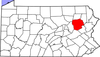
Luzerne County is a county in the Commonwealth of Pennsylvania. According to the United States Census Bureau, the county has a total area of 906 square miles (2,350 km2), of which 890 square miles (2,300 km2) is land and 16 square miles (41 km2) is water. It is Northeastern Pennsylvania's second-largest county by total area. As of the 2020 census, the population was 325,594, making it the most populous county in the northeastern part of the state. The county seat and largest city is Wilkes-Barre. Other populous communities include Hazleton, Kingston, Nanticoke, and Pittston. Luzerne County is included in the Scranton–Wilkes-Barre–Hazleton Metropolitan Statistical Area, which has a total population of 555,426 as of 2017.

Hanover Township is a township in Luzerne County, Pennsylvania. As of the 2020 census, the population was 11,424, making it the most populous township in the county.
Nanticoke is a city in Luzerne County, Pennsylvania, United States. As of the 2020 census, the population was 10,628, making it the third largest city in Luzerne County. It occupies 3.5 square miles of land. Nanticoke is part of Northeastern Pennsylvania.

Pittston Township is a township in Luzerne County, Pennsylvania. The population was 3,179 as of the 2020 census. The township is located within the Greater Pittston region. As of 2010, the total population of Greater Pittston was 48,020. The Wilkes-Barre/Scranton International Airport is located in Pittston Township.

Plymouth Township is located in Luzerne County, Pennsylvania, United States. The population was 1,712 at the 2020 census.
Wilkes-Barre Township is a township with home rule status in Luzerne County, Pennsylvania, United States. It is adjacent to the city of Wilkes-Barre. The population of the township was 3,219 at the 2020 census.
On April 5–6, 1936, an outbreak of 14 tornadoes struck the Southeastern United States, killing at least 454 people and injuring at least 2,500 others. Over 200 people died in Georgia alone, making it the deadliest disaster ever recorded in the state.
The 1947 Glazier–Higgins–Woodward tornadoes were a series of related tornadoes spawned by a single supercell that swept through the U.S. states of Texas, Oklahoma, and Kansas on Wednesday, April 9, 1947. Most of the damage and all the deaths are still blamed on one large F5 tornado, known as the Glazier–Higgins–Woodward Tornado, that traveled nearly 125 miles from Texas to Oklahoma. This event was often compared to the Tri-State Tornado, because it was originally thought to have left a 219-mile path, but it is now believed to have been part of a family of eight or nine tornadoes.

The 1899 New Richmond tornado was an estimated F5 tornado which formed in the early evening of Monday, June 12, 1899, and tore a 45-mile path of destruction through St. Croix, Polk, and Barron counties in west-central Wisconsin. It killed 117 people, injured twice as many, and left hundreds homeless. The worst devastation occurred in the city of New Richmond, which took a direct hit from the storm. Over half the town was left in ruins by the tornado, which also caused minor damage to surrounding communities. More than $300,000 (USD) in damage was reported. As of 2019, it ranks as the ninth deadliest tornado in United States history, as well as the deadliest ever recorded in Wisconsin.
The 1919 Fergus Falls tornado was a large and destructive tornado that struck Fergus Falls, Minnesota on Sunday, June 22, 1919. It killed 57 people and is the second deadliest tornado in Minnesota's history. This tornado occurred just 10 months after a tornado in Tyler, Minnesota killed 36 people. That twister was Minnesota's fourth deadliest on record.
The 1924 Lorain–Sandusky tornado was a deadly F4 tornado which struck the towns of Sandusky and Lorain, Ohio on Saturday, June 28, 1924. It remains the deadliest single tornado ever recorded in Ohio history, killing more people than the infamous 1974 Xenia and 1985 Niles-Wheatland tornadoes combined.

A multi-day tornado outbreak affected the central plains of the United States from May 22–27, 2008. It was also one of the largest continuous tornado outbreaks on record. A total of 173 tornadoes were confirmed, with the most intense activity occurring across the Great Plains. One person was killed when a large wedge tornado struck Windsor, Colorado, and two more deaths were reported in Pratt County, Kansas. One person was also killed near Hugo, Minnesota on May 25 and nine were killed by an EF5 tornado that destroyed most of Parkersburg, Iowa and a small subdivision of New Hartford, Iowa. Another fatality, caused by lightning related to the storms, occurred in central Kansas.
The Luzerne County Transportation Authority (LCTA) is the operator of mass transportation in the city of Wilkes-Barre, Pennsylvania, and portions of surrounding Luzerne County. Services provided by the LCTA replaced previously offered services of the White Transit Company and Wilkes-Barre Transit Corporation, under a purchase-of-service agreement in 1972.
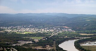
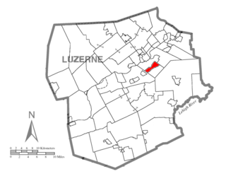
Korn Krest is a village in Hanover Township, Luzerne County, Pennsylvania. It is located in the Wyoming Valley between Wilkes-Barre and Nanticoke on the south side of the Sans Souci Parkway, which is a main thoroughfare connecting the two cities and is locally pronounced "San Suey." Hanover Township Area Jr/Sr High School is located in Korn Krest on the former site of Sans Souci Park, an amusement park that closed in 1970 and was first named Hanover Park from 1893 to 1905. The village uses the Wilkes-Barre/Hanover Township zip code of 18706.

Solomon Creek is a tributary of the Susquehanna River in Luzerne County, Pennsylvania, in the United States. It is approximately 8.8 miles (14.2 km) long and flows through Fairview Township, Hanover Township, and Wilkes-Barre. The creek is affected by acid mine drainage and has significant loads of iron, aluminum, and manganese. The creek's named tributaries are Spring Run, Sugar Notch Run, and Pine Creek. The Solomon Creek watershed is located in the Anthracite Valley section of the ridge-and-valley geographical province. Major rock formations in the watershed include the Mauch Chunk Formation, the Spechty Kopf Formation, and the Catskill Formation.

Nanticoke Creek is a tributary of the Susquehanna River in Luzerne County, Pennsylvania, in the United States. It is approximately 4.4 miles (7.1 km) long and flows through Hanover Township and Nanticoke. The watershed of the creek has an area of 7.57 square miles (19.6 km2). The creek has one named tributary, which is known as Espy Run. Nanticoke Creek impaired by pH and metals due to abandoned mine drainage. Abandoned mine drainage discharges in the creek's watershed include the Truesdale Mine Discharge and the Askam Borehole. The creek is located in the Northern Middle Anthracite Field and is in the Anthracite Valley Section of the ridge and valley physiographic province. The main rock formations in the watershed include the Mauch Chunk Formation, the Pottsville Group, and the Llewellyn Formation. The surficial geology consists of coal dumps, surface mining land, alluvium, Wisconsinan Outwash, Wisconsinan Till, urban land, and bedrock.

This page documents the tornadoes and tornado outbreaks of 1949, primarily in the United States. Most recorded tornadoes form in the U.S., although some events may take place internationally. Tornado statistics for older years like this often appear significantly lower than modern years due to fewer reports or confirmed tornadoes.

On April 3, 1974, an extremely destructive tornado struck the city of Xenia and town of Wilberforce, Ohio, killing 36 people. The tornado stands as the deadliest individual tornado of the 1974 Super Outbreak. The tornado completely destroyed a large portion of Xenia, which caused meteorologist Dr. Ted Fujita to initially assign a preliminary rating of F6 intensity ± 1 on the Fujita scale, making it one of only two tornadoes to receive the rating, the other being the 1970 Lubbock tornado that occurred four years earlier. This was later downgraded to F5 after Fujita deemed F6 ratings "inconceivable".
References
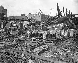
- 1 2 US Department of Commerce, NOAA. "August 19, 1890 Wilkes Barre Tornado". www.weather.gov.
- ↑ Notes on the tornado of August 19, 1890, in Luzerne and Columbia counties: a paper read before the Wyoming Historical and Geological Society, December 12, 1890. Wyoming Historical & Geological Society. September 9, 1891. OCLC 12535383 – via Open WorldCat.
- 1 2 Cappucci, Matthew. "Analysis | Striking in the dark of night, the Wilkes-Barre tornado was a freak" – via www.washingtonpost.com.
- 1 2 Leader, Times (June 16, 2018). "Lives lost in 1900s twisters that hit Wilkes-Barre City, Twp". Times Leader.
- ↑ "These were some of the deadliest tornadoes in Pa. history". pennlive. June 15, 2018.