1997 Red River flood

Last updated

1997 Red River flood
Sorlie bridge 1997.jpg
The Sorlie Bridge connecting Grand Forks and East Grand Forks became submerged on April 17
DateApril 1997
Location
Deaths0
Property damage$3.5 billion [1]

The Red River flood of 1997 was a major flood that occurred in April and May 1997 along the Red River of the North in Minnesota, North Dakota, and southern Manitoba. It was the most severe flood of the river since 1826. The flood reached throughout the Red River Valley, affecting the cities of Fargo and Winnipeg, but none so greatly as Grand Forks and East Grand Forks, where floodwaters reached more than 3 miles (4.8 km) inland. They inundated virtually everything in the twin communities. Total damages for the Red River region were US$3.5 billion. The flood was the result of abundant snowfall and extreme temperatures.

Contents

In Grand Forks, thousands of people, including Air Force personnel from Grand Forks Air Force Base, tried to prepare for the 1997 flood by building sandbag dikes. These dikes were constructed based on a 49-foot estimate of flooding set by the National Weather Service. The river crested at 54 feet in Grand Forks. Grand Forks mayor Pat Owens had to order the evacuation of more than 50,000 people, most of the population of the city, as a huge area was flooded. A large fire started in downtown Grand Forks, engulfing eleven buildings and sixty apartment units before being extinguished. Those affected by the flood in the U.S. received donations from across the nation, along with billions of dollars in federal aid. City officials and flood-forecasters were criticized for the difference in estimates and actual flood levels.

As a result of the 1997 flood and its extensive property losses, the United States and state governments made additional improvements to the flood protection system in North Dakota and Minnesota. A dike system was built on both sides of the river to protect the twin Forks cities. In the aftermath, the Federal Emergency Management Agency (FEMA) worked with the cities of Grand Forks and East Grand Forks to clear residential and business development from a large area of floodplain, because of the certainty of future regional floods, and also as the floodplain is intended to be a natural means to absorb floodwaters. They also redeveloped the floodplain along the river as the Greater Grand Forks Greenway, including several parks, a Minnesota state campground recreation area, and a 20-mile biking and walking trail.

Flooding in Manitoba resulted in over $500 million in damages. The Red River Floodway, an artificial waterway completed in 1968 and nicknamed "Duff's Ditch", exceeded its capacity flow but managed to divert the floodwaters around Winnipeg which minimized damage. From 2005 to 2010, the province made substantial upgrades to inlet control structures and fire protection, increased elevation of existing dikes (including the Brunkild dike), and widened the floodway channel.

Previous floods

A before and after view of a building that caught fire in downtown Grand Forks during the 1997 Red River flood. GF1997firebeforeafter.jpg
A before and after view of a building that caught fire in downtown Grand Forks during the 1997 Red River flood.

The Red River of the North has flooded repeatedly through the centuries. It is highly prone to spring flooding because of its northward flow, the nearly flat former lake bed of the valley, and ice formation on the river. As spring approaches, the snow melts from south to north in the same direction as the riverflow. At times high waters encounter ice on the river and back up, spreading out of the banks. The wide flatness of the terrain, formed from an ancient lake bed, and the low slope of the river also contribute to severe flooding in the region.[ citation needed ]

Serious floods occurred in 1948 and 1950. The 1950 flood reached a high of 30 ft (9.2 m) at Winnipeg and caused the largest evacuation in Canada's history: an estimated 70,000 to 100,000 people had to be evacuated. An estimated $606 million CAD (1997) of damage resulted. In the aftermath, the government of Manitoba and the Canadian federal government constructed flood safety measures. [2]

The first known records of floods along the Red River were documented in the 1770s. Severe floods have occurred throughout the 19th and 20th centuries, including in 1979. [3] Residents and officials incorrectly assumed that homes that were safe in 1979 would be beyond the reach of a future flood.

Impacts

North Dakota and Minnesota

The Red River forms the border between Minnesota and North Dakota. A few sets of "sister cities" developed along opposite sides of the river. Grand Forks, North Dakota and its counterpart East Grand Forks, Minnesota, were the pair most severely affected by the 1997 flood.[ citation needed ] Fargo, North Dakota/Moorhead, Minnesota (Fargo-Moorhead) and Wahpeton, North Dakota/Breckenridge, Minnesota also had severe flooding. Much of the flooding accumulated not only because of the rising river levels, but also from overland flooding, as meltwater did not drain away. Temporary dikes were erected along the riverfront and around the edges of towns, but were sometimes overwhelmed.[ citation needed ]

It was difficult for the cities to prepare for such an enormous flood. The National Weather Service (NWS) had forecast that the river would crest at 49 feet (14.9 m), [4] which was its highest level during the 1979 flood. [5] The cities had built dikes to this level, but the river continued to rise past it. Taken by surprise, the NWS did not upgrade its forecast until April 16, the day the river reached 49 feet. [4] [6]

The dikes in the low-lying Lincoln Drive neighborhood of Grand Forks were the first to break, doing so early on April 18, as the river kept rising. [7] Other dikes in the Grand Forks and East Grand Forks area failed that day and the next, flooding thousands of homes. During this time, Grand Forks mayor Pat Owens ordered the evacuation of more than 50,000 people, much of the population of the city. This was the largest evacuation in the United States since the evacuation of residents in Atlanta, Georgia during the Civil War. [8]

Grand Forks after a levee overtopped and Grand Forks was evacuated RedRiverGrandForks1997.jpg
Grand Forks after a levee overtopped and Grand Forks was evacuated

Water reached areas more than two miles (3 km) inland from the Red River, requiring evacuation of all of East Grand Forks and 75% of Grand Forks. School was cancelled in both cities for the remainder of the term, as were classes at the University of North Dakota. [9] All transportation was cut off between the two cities (and for many miles, the two states). East Grand Forks residents were evacuated to nearby Crookston, namely to the University of Minnesota Crookston. Residents of Grand Forks were given mandatory evacuation orders on April 18, and retreated to Grand Forks Air Force Base (residents stayed in airplane hangars, which were supplied with more than 3,000 cots). [10] [11] [12] Many residents also evacuated to motels and homes in outlying communities.

The river crested at 54.35 feet (16.6 m) on April 21, and the river level did not fall below 49 feet (14.9 m) until April 26. [13] Because water drained so slowly out of the most low-lying areas, some homeowners could not visit their damaged properties until May. By May 30, the Red River had receded below flood stages everywhere in North Dakota. [14]

Manitoba

Red River Floodway near Winnipeg Rednorthfloodwaymap.png
Red River Floodway near Winnipeg

The province of Manitoba completed the Red River Floodway in 1968 after six years of construction, built permanent dikes in eight towns south of Winnipeg, and built clay dikes and diversion dams in the Winnipeg area. Other flood control structures completed later were the Portage Diversion and the Shellmouth Dam on the Assiniboine River. Even with these flood protection measures, in 1997 the province had a flood cresting at 21.6 ft (6.6 m). It caused 28,000 people to be evacuated and $500 million CAD in damage to property and infrastructure. [15] [16]

The 1997 flood was a 100-year flood. It came close to overwhelming Winnipeg's existing flood protection system. [17] At the time, the Winnipeg Floodway was designed to protect against a flow of 60,000 cu ft/s (1,700 m3/s), but the 1997 flow was 63,000 cu ft/s (1,800 m3/s).

To compensate, the province broke operational rules for the Floodway, as defined in legislation, during the night of April 30 / May 1, to prevent waters in Winnipeg from rising above the designed limit of 24.5 ft (7.5 m) above the "James Avenue datum", but causing additional flooding upriver. Winnipeg Mayor Susan Thompson, announcing that the design limit had been reached, misinterpreted this as good news that the flooding had peaked. City sand-bagging stopped, and national reporters left the city, but the water continued to rise inside and outside of the city [18] until the peak late on May 3 / early on May 4. The city officials have said that the peak occurred on May 1; [19] scientific reports record a peak on May 3/4. [20] [21]

Towns upriver of Winnipeg, forewarned by footage of buildings in Grand Forks burning and covered in meters of water, built ring dikes to protect their homes and properties. The province of Manitoba called in the Canadian Forces, the Royal Canadian Mounted Police, and the provincial Department of Natural Resources. Many people chose to evacuate, including residents from Morris, who had only two days notice to evacuate to Winnipeg. Thousands of volunteers helped to build sandbag dikes around homes and property. [17] An emergency 42 km (26 mi) long dike, later called the Brunkild Z-dike, was constructed in a matter of days when officials realized that overland flooding threatened the city of Winnipeg. It cost $10 million (CAD). [22]

Almost all of the ring dikes around the towns held, except for that at Ste. Agathe. The town's dike system was prepared for the river approaching from the south, but the river had spread widely and floodwaters swamped the town from the west. [15] At the flood's peak in Canada on May 4, the Red River occupied an area of 1,840 km2 (710 mi2) with more than 2,560 km2 (990 mi2) of land underwater, which earned it the nickname "Red Sea." [16]

While the flooding was still underway, the federal Liberal government led by Jean Chrétien called a snap election. Several of the party's MPs from the province, including Reg Alcock, requested a delay until the flooding was under control. [23] When Chrétien let the election go ahead as originally planned, Alcock transformed his campaign office into a volunteer relief centre, spending his time in relief efforts instead of campaigning, and won re-election. [24] [25]

Aftermath

In July, Canadian Prime Minister Jean Chrétien and United States President Bill Clinton appointed the International Red River Basin Task Force, comprising members from both countries. The task force's purpose was to find ways to improve flood forecasting. [16] [26]

The province of Manitoba asked the International Joint Commission (IJC) to provide a report on the flood event and to recommend measures to ensure further flood protection for the city of Winnipeg. [16] Largely as a result of this study, the province widened the floodway between 2004 and 2010.

Societal response

See also

Related Research Articles

<span class="mw-page-title-main">Red River of the North</span> River in the United States and Canada

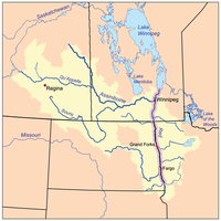
The Red River, also called the Red River of the North to differentiate it from the Red River in the south of the continent, is a river in the north-central United States and central Canada. Originating at the confluence of the Bois de Sioux and Otter Tail rivers between the U.S. states of Minnesota and North Dakota, it flows northward through the Red River Valley, forming most of the border of Minnesota and North Dakota and continuing into Manitoba. It empties into Lake Winnipeg, whose waters join the Nelson River and ultimately flow into Hudson Bay.

<span class="mw-page-title-main">Red River Floodway</span> Artificial flood control channel in Manitoba, Canada

The Red River Floodway is an artificial flood control waterway in Western Canada. It is a 47 km (29 mi) long channel which, during flood periods, takes part of the Red River's flow around the city of Winnipeg, Manitoba to the east and discharges it back into the Red River below the dam at Lockport. It can carry floodwater at a rate of up to 140,000 cubic feet per second (4,000 m3/s), expanded in the 2000s from its original channel capacity of 90,000 cubic feet per second (2,500 m3/s).

<i>Grand Forks Herald</i> Daily newspaper from North Dakota, US

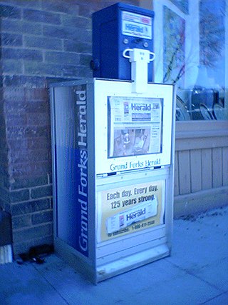
The Grand Forks Herald is a daily broadsheet newspaper, established in 1879, published in Grand Forks, North Dakota, United States. It is the primary daily paper for northeast North Dakota and northwest Minnesota. Its average daily circulation is approximately 7,500, in the city of Grand Forks plus about 7,500 more to the surrounding communities. Total circulation includes digital subscribers. It has the second largest circulation in the state of North Dakota.

<span class="mw-page-title-main">Red River Valley</span> Region in central North America that is drained by the Red River of the North

The Red River Valley is a region in central North America that is drained by the Red River of the North; it is part of both Canada and the United States. Forming the border between Minnesota and North Dakota when these territories were admitted as states in the United States, this fertile valley has been important to the economies of these states and to Manitoba, Canada.

<span class="mw-page-title-main">WDAZ-TV</span> ABC affiliate in North Dakota

WDAZ-TV is a television station licensed to Devils Lake, North Dakota, United States, serving the Grand Forks area as an affiliate of ABC. It is owned by the Forum Communications Company, which also owns the Grand Forks Herald. WDAZ-TV's news bureau and advertising sales office are located on South Washington Street in Grand Forks, and its transmitter is located near Dahlen, North Dakota. Despite Devils Lake being WDAZ-TV's city of license, the station maintains no physical presence there.

<span class="mw-page-title-main">Sheyenne River</span>

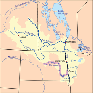
The Sheyenne River is one of the major tributaries of the Red River of the North, meandering 591 miles (951 km) across eastern North Dakota, United States.

<span class="mw-page-title-main">Greater Grand Forks Greenway</span>

The Greater Grand Forks Greenway is a huge greenway bordering the Red River and Red Lake River in the twin cities of Grand Forks, North Dakota and East Grand Forks, Minnesota. At 2,200 acres (9 km2), the Greenway is more than twice the size of New York City's Central Park. It has an extensive, 20-mile (32 km) system of bike paths, which are used by bikers, walkers, joggers, and rollerbladers. In 2007, the system was designated as a National Recreation Trail by the National Park Service.

<span class="mw-page-title-main">KFGO (AM)</span> Radio station in Fargo, North Dakota

KFGO is an AM radio station in the United States. Licensed to Fargo, North Dakota, KFGO broadcasts a news and talk radio format serving the Fargo-Moorhead metropolitan area, branded "The Mighty 790, 94.1, and 104.7". The station is currently owned by Midwest Communications Inc. All the offices and studios are located at 1020 S. 25th Street in Fargo, while its transmitter array is located north of Oxbow. It is an affiliate of the CBS Radio Network. KFGO is simulcast on KFGO-FM and translator K231CV.

<span class="mw-page-title-main">1950 Red River flood</span> Historic flood in North Dakota, United States and Manitoba, Canada

The 1950 Red River flood was a devastating flood that took place along the Red River in The Dakotas and Manitoba from April 15 to June 12, 1950. Damage was particularly severe in the city of Winnipeg and its environs, which were inundated on May 5, also known as Black Friday to some residents.

<span class="mw-page-title-main">Portage Diversion</span> Spillway in Manitoba, Canada

The Portage Diversion is a water control structure on the Assiniboine River near Portage la Prairie, Manitoba, Canada. The project was made as part of a larger attempt to prevent flooding in the Red River Valley. The Portage Diversion consists of two separate gates which divert some of the flow of water in the Assiniboine River to a 29 km long diversion channel that empties into Lake Manitoba near Delta Beach. This helps prevent flooding on the Assiniboine down river from the diversion, including in Winnipeg, where the Assiniboine River meets the Red River.

The recorded history of Grand Forks in the U.S. state of North Dakota, began with the trade between Native Americans and French fur trappers during the 19th century. About 60 buildings or other historic sites in Grand Forks survive and are recognized among the National Register of Historic Places listings in Grand Forks County.

<span class="mw-page-title-main">1997 Red River flood in the United States</span> Flood in the United States in 1997

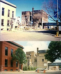
The Red River flood of 1997 in the United States was a major flood that occurred in April 1997, along the Red River of the North in North Dakota and Minnesota. The flood reached throughout the Red River Valley, affecting the cities of Fargo, Moorhead, and Winnipeg, while Grand Forks and East Grand Forks received the most damage, where floodwaters reached over 3 miles (5 km) inland, inundating virtually everything in the twin communities. Total damages for the Red River region were US$3.5 billion.

<span class="mw-page-title-main">2009 Red River flood</span>

The 2009 Red River flood along the Red River of the North in North Dakota and Minnesota in the United States and Manitoba in Canada brought record flood levels to the Fargo-Moorhead area. The flood was a result of saturated and frozen ground, spring snowmelt exacerbated by additional rain and snow storms, and virtually flat terrain. Communities along the Red River prepared for more than a week as the U.S. National Weather Service continuously updated the predictions for the city of Fargo, North Dakota, with an increasingly higher projected river crest. Originally predicted to reach a level of near 43 feet (13 m) at Fargo by March 29, the river in fact crested at 40.84 feet (12.45 m) at 12:15 a.m. March 28, and started a slow decline. The river continued to rise to the north as the crest moved downstream.

The US State of North Dakota experienced significant flooding in its major river basins in 2009, following abnormally heavy winter snows atop saturated and frozen ground.

<span class="mw-page-title-main">Red River floods</span> Index of articles associated with the same name

The Red River floods refer to the various flooding events in recent history of the Red River of the North, which forms the border between North Dakota and Minnesota and flows north, into Manitoba.

<span class="mw-page-title-main">2011 Red River flood</span> 2011 flood affecting Canada and the US

The 2011 Red River flood took place along the Red River of the North in Manitoba in Canada and North Dakota and Minnesota in the United States beginning in April 2011. The flood was, in part, due to high moisture levels in the soil from the previous year, which meant that further accumulation would threaten the flood-prone region. Flood predictors in Winnipeg were worried that a dual crest of both the Assiniboine River and the Red might crest at the city at the same time. Beginning around April 8, 50 homes were evacuated and two more were flooded after an ice jam in St. Andrews, Manitoba caused the river to flood over its banks.

The 2011 Assiniboine River flood was caused by above average precipitation in Western Manitoba and Saskatchewan. This was a 1 in 300 year flood that affected much of Western Manitoba. The flooding in Manitoba was expected to mostly involve the 2011 Red River Flood but instead the more severe flooding was found on the Assiniboine in the west.

<span class="mw-page-title-main">2011 Souris River flood</span> 2011 flood affecting Canada and USA

The 2011 Souris/Mouse River flood in Canada and the United States occurred in June and was greater than a hundred-year flooding event for the river. The US Army Corps of Engineers estimated the flood to have a recurrence interval of two to five centuries.

The Northern Great Plains History Conference is an annual conference of history professors, graduate students, historical society experts, and other scholars interested in the history of the Great Plains states of the American Midwest. The Conference features scholarly papers by academics and advanced students on a variety of topics, especially in social history and military history, as well as regional topics regarding the Great Plains.

<span class="mw-page-title-main">Fargo-Moorhead Area Diversion Project</span> Flood control project on the Red River

The Fargo-Moorhead (FM) Area Diversion project, officially known as the Fargo-Moorhead Metropolitan Area Diversion Flood Risk Management Project, is a large, regional flood control infrastructure project on the Red River of the North, which forms the border between North Dakota and Minnesota and flows north to Lake Winnipeg in Manitoba, Canada.

References

  1. Shelby, p. 149
  2. "A city submerged: Winnipeg and the flood of 1950". CBC. Retrieved September 17, 2007.
  3. "A History of Flooding in the Red River Basin" (PDF). USGS. Retrieved October 3, 2007.
  4. 1 2 "Flood of criticism from 1997 floods: Did faulty forecasts add to disaster?". USA Today. November 10, 1999. Retrieved November 3, 2007.
  5. "Record floods along the Red River in 1997". USA Today. November 10, 1999. Retrieved November 3, 2007.
  6. Shelby, p. 60
  7. Shelby, p. 66
  8. Shelby, Ashley (2003). Red River Rising. United States: Borealis Books. p. 102. ISBN   0-87351-500-5.
  9. "Great Flood of '97". University of North Dakota. Archived from the original on March 11, 2008. Retrieved November 3, 2007.
  10. Shelby, p. 86
  11. Shelby, p. 121
  12. Jacobs, p. 68
  13. "Grand Forks 1997 Flood Recovery: Facts and Statistics". FEMA. Archived from the original on March 28, 2009. Retrieved October 1, 2007.
  14. Douglas C. Friez; Kathleen Donahue (March 1998). "North Dakota After Action Report – Historical Perspective". North Dakota Emergency Management. Archived from the original on February 22, 2001. Retrieved October 4, 2007.
  15. 1 2 Hutton, David (November 1, 2004). "Psychosocial effects of a natural disaster: a post-flood assessment in the Red River Valley". Environments. Archived from the original on March 27, 2009. Retrieved November 3, 2007.
  16. 1 2 3 4 Etkin, David; Chowdhury Emdadul Haque; Gregory Robert Brooks (2003). An Assessment of Natural Hazards and Disasters in Canada. London: Springer. p. 349. ISBN   1-4020-1179-2.
  17. 1 2 Fong, Petti (May 5, 2007). "Bracing for the next 'flood of the century'". The Star. Toronto. Retrieved November 3, 2007.
  18. "Artificial Crest to keep Red high well into June". Winnipeg Free Press. May 4, 1997. p. 2.
  19. "Flood of the Century: Chronology of Flood Events – 1997". City of Winnipeg. Retrieved January 13, 2017.
  20. "Flood of the Century: What does James mean?". City of Winnipeg. Retrieved February 27, 2017.
  21. "Diking Commissioner's Reports". Archived from the original on May 7, 2011. Retrieved May 13, 2011.
  22. "1997's 'Z-dike' showcased province's flood-fighting machine". CBC News. April 25, 2007.
  23. Lett, Dan (April 15, 1997). "MPs want vote delayed". Winnipeg Free Press .
  24. Robertson, Bud (April 29, 1997). "Politicians unite against flood". Winnipeg Free Press .
  25. Harper, Tim (April 29, 1997). "McDonough says election call 'insensitive'". Toronto Star .
  26. Shelby, p. 139
  27. 1 2 3 4 5 6 Hagen, Carol A.; Ender, Morten G.; Tiemann, Kathleen A.; Hagen, Clifford O. Jr. (1999). "Graffiti on the Great Plains: A Social Reaction to the Red River Valley Flood of 1997". Applied Behavioral Science Review. 7 (2). Elsevier Science Inc.: 145–158. doi:10.1016/S1068-8595(00)80015-X. ISSN   1068-8595.
  28. Pielke, Roger A. Jr. (1999). "Who Decides? Forecasts and Responsibilities in the 1997 Red River Flood". Applied Behavioral Science Review. 7 (2): 83–101. doi:10.1016/S1068-8595(00)80012-4. Archived from the original on September 25, 2016. Retrieved November 22, 2016.

Further reading