
The Times Square–42nd Street/Port Authority Bus Terminal station is a major New York City Subway station complex located under Times Square and the Port Authority Bus Terminal, at the intersection of 42nd Street, Seventh and Eighth Avenues and Broadway in Midtown Manhattan. The complex allows free transfers between the IRT 42nd Street Shuttle, the BMT Broadway Line, the IRT Broadway–Seventh Avenue Line and the IRT Flushing Line, with a long transfer to the IND Eighth Avenue Line one block west at 42nd Street–Port Authority Bus Terminal. The complex is served by the 1, 2, 3, 7, A, E, N and Q trains at all times, the W train during weekdays, the C, R and 42nd Street Shuttle (S) trains at all times except late nights, and by <7> trains during rush hours in the peak direction. A free passageway from the shuttle platform to the 42nd Street–Bryant Park/Fifth Avenue station, served by the 7, <7>, B, D, F, <F>, and M trains, is open during the day from 6 a.m. to 12 a.m.

The IRT Ninth Avenue Line, often called the Ninth Avenue Elevated or Ninth Avenue El, was the first elevated railway in New York City. It opened on July 3, 1868 as the West Side and Yonkers Patent Railway, as an experimental single-track cable-powered elevated railway from Battery Place, at the south end of Manhattan Island, northward up Greenwich Street to Cortlandt Street. It ceased operation on June 11, 1940, after it was replaced by the IND Eighth Avenue Line which had opened in 1932.
The IRT Broadway–Seventh Avenue Line is a New York City Subway line. It is one of several lines that serves the A Division, stretching from South Ferry in Lower Manhattan north to Van Cortlandt Park–242nd Street in Riverdale, Bronx. The Brooklyn Branch, known as the Wall and William Streets Branch during construction, from the main line at Chambers Street southeast through the Clark Street Tunnel to Borough Hall in Downtown Brooklyn, is also part of the Broadway–Seventh Avenue Line. The IRT Broadway–Seventh Avenue Line is the only line to have elevated stations in Manhattan, with two short stretches of elevated track at 125th Street and between Dyckman and 225th Streets.

The Grand Central–42nd Street station is a major station complex of the New York City Subway. Located in Midtown Manhattan at 42nd Street between Madison and Lexington Avenues, it serves trains on the IRT Lexington Avenue Line, the IRT Flushing Line and the 42nd Street Shuttle. The complex is served by the 4, 6, and 7 trains at all times; the 5 and 42nd Street Shuttle (S) trains at all times except late nights; the <6> train during weekdays in the peak direction; and the <7> train during rush hours and early evenings in the peak direction.
The IRT Lexington Avenue Line is one of the lines of the A Division of the New York City Subway, stretching from Lower Manhattan north to 125th Street in East Harlem. The line is served by the 4, 5, 6, and <6> trains.

The IRT Third Avenue Line, commonly known as the Third Avenue Elevated, Third Avenue El, or Bronx El, was an elevated railway in Manhattan and the Bronx, New York City. Originally operated by the New York Elevated Railway, an independent railway company, it was acquired by the Interborough Rapid Transit Company (IRT) and eventually became part of the New York City Subway system.
The South Ferry station was an elevated station at the southern terminal of the IRT Second, Third, Sixth and Ninth Avenue Lines. It was located next to Battery Park at the lower tip of Manhattan, New York City. Two tracks came from the combined Second and Third Avenue Lines, and two from the Sixth and Ninth Avenue Lines, making four tracks at the terminal, with platforms on the outside and between each pair of tracks.
The White Plains Road Line is a rapid transit line of the A Division of the New York City Subway serving the central Bronx. It is mostly elevated and served both subway and elevated trains until 1952. The original part of the line, the part opened as part of the first subway was called the West Farms Division, and the extension north to 241st Street as part of the Dual Contracts was called the White Plains Road Line. Eventually, however, the two parts came to be known as the White Plains Road Line.
The BMT Astoria Line is a rapid transit line of the B Division of the New York City Subway, serving the Queens neighborhood of Astoria. It runs south from Ditmars Boulevard in Astoria to 39th Avenue in Long Island City above 31st Street. It then turns west and serves Queensboro Plaza over Queens Plaza.
The BMT Fourth Avenue Line is a rapid transit line of the New York City Subway, mainly running under Fourth Avenue in Brooklyn. The line is served by the D, N, and R at all times; the R typically runs local, while the D and N run express during the day and local at night. During rush hours, select W and northbound Q trains also serve the line. Limited rush-hour N trains operate local on the line in the reverse-peak direction. The line was originally built by the Brooklyn Rapid Transit Company and is now internally operated as part of the New York City Subway's B Division.

The South Ferry/Whitehall Street station is a New York City Subway station complex in the Financial District neighborhood of Manhattan, under Battery Park. The complex is shared by the IRT Broadway–Seventh Avenue Line and the BMT Broadway Line. It is served by the 1 and R trains at all times, the N train during late nights only, and the W train during weekdays only.

The first regularly operated subway in New York City was opened on October 27, 1904, and was operated by the Interborough Rapid Transit Company (IRT). The early IRT system consisted of a single trunk line below 96th Street in Manhattan, running under Broadway, 42nd Street, Park Avenue, and Lafayette Street. The line had three northern branches in Upper Manhattan and the Bronx, and a southern branch to Brooklyn. The system had four tracks between Brooklyn Bridge–City Hall and 96th Street, allowing for local and express service. The original line and early extensions consisted of:

Transportation in New York City has ranged from strong Dutch authority in the 17th century, expansionism during the industrial era in the 19th century and half of the 20th century, to cronyism during the Robert Moses era. The shape of New York City's transportation system changed as the city did, and the result is an expansive modern-day system of industrial-era infrastructure. New York City, being the most populous city in the United States, has a transportation system which includes one of the largest subway systems in the world; the world's first mechanically ventilated vehicular tunnel; and an aerial tramway.
The 129th Street station was a transfer station on the IRT Third Avenue Line in Manhattan, New York City, shared by elevated trains of both the Third Avenue Line and IRT Second Avenue Line. The next stop to the north was 133rd Street for the main line and Willis Avenue for the Willis Avenue spur, both of which were across a swing bridge above the Harlem River in the Bronx. The next stop to the south was 125th Street−Third Avenue for Third Avenue Line trains and 125th Street−Second Avenue for Second Avenue Line trains.
The 34th Street station was a local station on the demolished IRT Third Avenue Line in Manhattan, New York City. The station was served by Third Avenue local trains and a shuttle to the 34th Street Ferry. Third Ave service originally had two tracks and two side platforms. During the Dual Contracts, a center express track was built. The shuttle to the ferry was served by two tracks and an island platform attached to the northbound side platform. North of the station the westbound track of the shuttle merged with the main line.

The 34th Street station was a local station on the demolished IRT Second Avenue Line in Manhattan, New York City. It had two levels. The upper level had three tracks and two side platforms and was used for the Second Avenue line trains. The lower level, also known as the Second Avenue station, had two tracks and one island platform and was used by 34th Street shuttle trains. The next stop to the north was 42nd Street. The next stop to the south was 23rd Street. The next eastbound stop on the shuttle was 34th Street Ferry. The next westbound stop on the shuttle was Third Avenue. The shuttle platform closed on July 14, 1930, and the main line station closed on June 13, 1942.

The Grand Central station was the terminal for some trains of the IRT Third Avenue Line, also known as the Third Avenue El, in Manhattan, New York City. This station originally had one island platform and two side platforms, all connected at the west end. The tracks ended just east of the Park Avenue Viaduct ramp over Pershing Square.

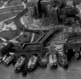
The East 34th Street Ferry Landing provides slips to ferries and excursion boats in the Port of New York and New Jersey. It is located on the East River in New York City east of the FDR Drive just north of East 34th Street in Midtown Manhattan. The facility, owned by the city, received Federal Highway Administration funding for improvements for docking facilities and upgrading the adjacent East River Greenway in 2008. A new terminal building was built and opened in 2016.


