Related Research Articles

The Independent Subway System, formerly known as the Independent City-Owned Subway System (ICOSS) or the Independent City-Owned Rapid Transit Railroad (ICORTR), was a rapid transit rail system in New York City that is now part of the New York City Subway. It was first constructed as the Eighth Avenue Line in Manhattan in 1932.
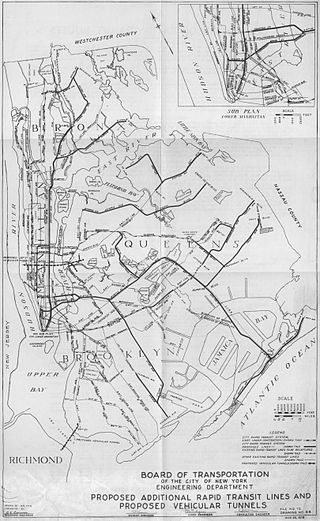
Since the opening of the original New York City Subway line in 1904, and throughout the subway's history, various official and planning agencies have proposed numerous extensions to the subway system. The first major expansion of the subway system was the Dual Contracts, a set of agreements between the City of New York and the IRT and the BRT. The system was expanded into the outer reaches of the Bronx, Brooklyn, and Queens, and it provided for the construction of important lines in Manhattan. This one expansion of the system provided for a majority of today's system.

The Dual Contracts, also known as the Dual Subway System, were contracts for the construction and/or rehabilitation and operation of rapid transit lines in the City of New York. The contracts were signed on March 19, 1913, by the Interborough Rapid Transit Company and the Brooklyn Rapid Transit Company. As part of the Dual Contracts, the IRT and BRT would build or upgrade several subway lines in New York City, then operate them for 49 years.

The Interborough Rapid Transit Company (IRT) was the private operator of New York City's original underground subway line that opened in 1904, as well as earlier elevated railways and additional rapid transit lines in New York City. The IRT was purchased by the city in June 1940, along with the younger BMT and IND systems, to form the modern New York City Subway. The former IRT lines are now the A Division or IRT Division of the Subway.

The IRT Ninth Avenue Line, often called the Ninth Avenue Elevated or Ninth Avenue El, was the first elevated railway in New York City. It opened on July 3, 1868 as the West Side and Yonkers Patent Railway, as an experimental single-track cable-powered elevated railway from Battery Place, at the south end of Manhattan Island, northward up Greenwich Street to Cortlandt Street. It ceased operation on June 11, 1940, after it was replaced by the IND Eighth Avenue Line which had opened in 1932.
The IND Sixth Avenue Line is a rapid transit line of the B Division of the New York City Subway in the United States. It runs mainly under Sixth Avenue in Manhattan, and continues south to Brooklyn. The B, D, F, and M trains, which use the Sixth Avenue Line through Midtown Manhattan, are colored orange. The B and D trains use the express tracks, while the F, <F> and M trains use the local tracks.

The New York City Subway is a rapid transit system that serves four of the five boroughs of New York City, New York: the Bronx, Brooklyn, Manhattan, and Queens. Its operator is the New York City Transit Authority (NYCTA), which is controlled by the Metropolitan Transportation Authority (MTA) of New York. In 2016, an average of 5.66 million passengers used the system daily, making it the busiest rapid transit system in the United States and the seventh busiest in the world.

The Park Row station was a major elevated railway terminal constructed on the Manhattan side of the Brooklyn Bridge, across from New York City Hall and the IRT’s elevated City Hall station. It served as the terminal for BMT services operating over the Brooklyn Bridge Elevated Line from the BMT Fulton Street Line, BMT Myrtle Avenue Line and their feeders. Until the opening of the nearby Williamsburg Bridge to elevated train traffic in 1913, it was the only Manhattan station available for elevated trains from Brooklyn, and the only elevated station in Manhattan to be owned by a company other than the IRT or its predecessors.

The IRT Third Avenue Line, commonly known as the Third Avenue Elevated, Third Avenue El, or Bronx El, was an elevated railway in Manhattan and the Bronx, New York City. Originally operated by the New York Elevated Railway, an independent railway company, it was acquired by the Interborough Rapid Transit Company (IRT) and eventually became part of the New York City Subway system.
The South Ferry station was an elevated station at the southern terminal of the IRT Second, Third, Sixth and Ninth Avenue Lines. It was located next to Battery Park at the lower tip of Manhattan, New York City. Two tracks came from the combined Second and Third Avenue Lines, and two from the Sixth and Ninth Avenue Lines, making four tracks at the terminal, with platforms on the outside and between each pair of tracks.
The White Plains Road Line is a rapid transit line of the A Division of the New York City Subway serving the central Bronx. It is mostly elevated and served both subway and elevated trains until 1952. The original part of the line, the part opened as part of the first subway was called the West Farms Division, and the extension north to 241st Street as part of the Dual Contracts was called the White Plains Road Line. Eventually, however, the two parts came to be known as the White Plains Road Line.

The Harlem–148th Street station is a New York City Subway station on the IRT Lenox Avenue Line in Harlem, Manhattan. It serves as the northern terminal station of the 3 train at all times as well as the Northern terminal of the IRT Lenox Avenue line. The entrance to the station is located at the intersection of 149th Street and Adam Clayton Powell Jr. Boulevard, which has historically been known as 7th Avenue. The station contains a pair of tracks and an island platform and is located at ground level. A parking structure for the adjacent Frederick Douglass Academy is located above the station, forming a roof above the platform and tracks.
The IRT Sixth Avenue Line, often called the Sixth Avenue Elevated or Sixth Avenue El, was the second elevated railway in Manhattan in New York City, following the Ninth Avenue Elevated.
The 155th Street station was an elevated railway station in Manhattan, New York City, that operated from 1870 until 1958. It served as the north terminal of the IRT Ninth Avenue Line from its opening until 1918 and then as the southern terminal of a surviving stub portion from 1940 until its closure in 1958. It had two tracks and one island platform.

The first regularly operated subway in New York City was opened on October 27, 1904, and was operated by the Interborough Rapid Transit Company (IRT). The early IRT system consisted of a single trunk line below 96th Street in Manhattan, running under Broadway, 42nd Street, Park Avenue, and Lafayette Street. The line had three northern branches in Upper Manhattan and the Bronx, and a southern branch to Brooklyn. The system had four tracks between Brooklyn Bridge–City Hall and 96th Street, allowing for local and express service. The original line and early extensions consisted of:
The Franklin Street station was a station on the demolished IRT Sixth Avenue Line in Manhattan, New York City. It was located at Franklin Street and West Broadway, and it had two tracks and two side platforms. There was space for two additional tracks in the station. South of the station there are two additional tracks that served to layup trains.
References
- ↑ "Subway Map" (PDF). Metropolitan Transportation Authority. September 2021. Retrieved September 17, 2021.
| | This Manhattan train station–related article is a stub. You can help Wikipedia by expanding it. |