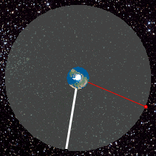
A geostationary orbit, also referred to as a geosynchronous equatorial orbit (GEO), is a circular geosynchronous orbit 35,786 km (22,236 mi) in altitude above Earth's equator, 42,164 km (26,199 mi) in radius from Earth's center, and following the direction of Earth's rotation.

A communications satellite is an artificial satellite that relays and amplifies radio telecommunication signals via a transponder; it creates a communication channel between a source transmitter and a receiver at different locations on Earth. Communications satellites are used for television, telephone, radio, internet, and military applications. Many communications satellites are in geostationary orbit 222,300 miles (357,800 km) above the equator, so that the satellite appears stationary at the same point in the sky; therefore the satellite dish antennas of ground stations can be aimed permanently at that spot and do not have to move to track the satellite. Others form satellite constellations in low Earth orbit, where antennas on the ground have to follow the position of the satellites and switch between satellites frequently.
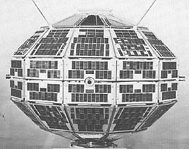
Alouette 1 is a deactivated Canadian satellite that studied the ionosphere. Launched in 1962, it was Canada's first satellite, and the first satellite constructed by a country other than the Soviet Union or the United States. Canada was the fourth country to operate a satellite, as the British Ariel 1, constructed in the United States by NASA, preceded Alouette 1 by five months. The name "Alouette" came from the French for "skylark" and the French-Canadian folk song of the same name.
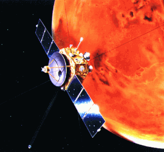
Nozomi was a Japanese Mars orbiter that failed to reach Mars due to electrical failure. It was constructed by the Institute of Space and Astronautical Science, University of Tokyo and launched on July 4, 1998, at 03:12 JST with an on-orbit dry mass of 258 kg and 282 kg of propellant. The Nozomi mission was terminated on December 31, 2003.
The Communications Technology Satellite (CTS), known as Hermes, was an experimental high-power direct broadcast communications satellite. It was a joint effort of Canadian Department of Communications, who designed and built the satellite, NASA who tested, launched and operated the satellite, and European Space Agency (ESA) who provided the 1200 watts solar panels and other devices. The three agencies shared the satellite and the data from the experiments.

Ranger 9 was a Lunar probe, launched in 1965 by NASA. It was designed to achieve a lunar impact trajectory and to transmit high-resolution photographs of the lunar surface during the final minutes of flight up to impact. The spacecraft carried six television vidicon cameras—two wide-angle and four narrow-angle —to accomplish these objectives. The cameras were arranged in two separate chains, or channels, each self-contained with separate power supplies, timers, and transmitters so as to afford the greatest reliability and probability of obtaining high-quality television pictures. These images were broadcast live on television to millions of viewers across the United States. No other experiments were carried on the spacecraft.

ATS-6 was a NASA experimental satellite, built by Fairchild Space and Electronics Division It has been called the world's first educational satellite as well as world's first experimental Direct Broadcast Satellite as part of the Satellite Instructional Television Experiment between NASA and Indian Space Research Organisation (ISRO). It was launched May 30, 1974, and decommissioned July 1979. At the time of launch, it was the most powerful telecommunication satellite in orbit. ATS-6 carried no fewer than 23 different experiments, and introduced several breakthroughs. It was the first 3-axis stabilized spacecraft in geostationary orbit. It was also the first to use experimentally with some success electric propulsion in geostationary orbit. It also carried several particle physics experiments, including the first heavy ion detector in geostationary orbit.
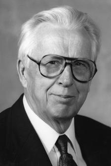
Verner Edward Suomi was a Finnish-American educator, inventor, and scientist. He is considered the father of satellite meteorology. He invented the Spin Scan Radiometer, which for many years was the instrument on the GOES weather satellites that generated the time sequences of cloud images seen on television weather shows. The Suomi NPP polar orbiting satellite, launched in 2011, was named in his honor.
The Applications Technology Satellites (ATS) were a series of experimental satellites launched by NASA, under the supervision of, among others, Wernher von Braun. The program was launched in 1966 to test the feasibility of placing a satellite into geosynchronous orbit. The satellites were primarily designed to act as communication satellites, but also carried equipment related to meteorology and navigation. ATS-6 was the world's first educational satellite as well as world's first experimental Direct Broadcast Satellite (DBS) as part of the Satellite Instructional Television Experiment (SITE) between NASA and ISRO.
The Space Test Program (STP) is the primary provider of spaceflight for the United States Department of Defense (DoD) space science and technology community. STP is managed by a group within the Advanced Systems and Development Directorate, a directorate of the Space and Missile Systems Center of the United States Space Force. STP provides spaceflight via the International Space Station (ISS), piggybacks, secondary payloads and dedicated launch services.

The Lincoln Experimental Satellite series was designed and built by Lincoln Laboratory at Massachusetts Institute of Technology between 1965 and 1976, under USAF sponsorship, for testing devices and techniques for satellite communication.

Earth Observing-1 (EO-1) is a decommissioned NASA Earth observation satellite created to develop and validate a number of instrument and spacecraft bus breakthrough technologies. It was intended to enable the development of future Earth imaging observatories that will have a significant increase in performance while also having reduced cost and mass. The spacecraft was part of the New Millennium Program. It was the first satellite to map active lava flows from space; the first to measure a facility's methane leak from space; and the first to track re-growth in a partially logged Amazon forest from space. EO-1 captured scenes such as the ash after the World Trade Center attacks, the flooding in New Orleans after Hurricane Katrina, volcanic eruptions and a large methane leak in southern California.

Fast, Affordable, Science and Technology Satellite-Huntsville 01 or FASTSAT-Huntsville 01 of the NASA. FASTSAT-HSV 01 was flying on the STP-S26 mission - a joint activity between NASA and the U.S. Department of Defense Space Test Program, or DoD STP. FASTSAT and all of its six experiments flying on the STP-S26 multi-spacecraft/payload mission have been approved by the Department of Defense Space and Experiments Review Board (USA-220).

DODGE was a satellite whose primary purpose was to conduct experiments in gravity-gradient stabilization at near-geosynchronous altitudes. Its secondary objectives included measuring the Earth's magnetic field, and taking pictures of the entire Earth's disk in both black-and-white and color. It was launched atop a Titan IIIC rocket on July 1, 1967, and operated for over three years. DODGE carried ten knobbed booms oriented along three different axes, that could be independently extended and retracted by ground command.
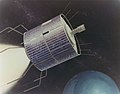
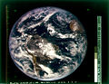
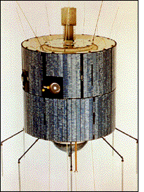
ATS-1, also designated ATS-B or Advanced Tech. Sat. 1, was an experimental geostationary satellite, launched in 1966. Though intended as a communications satellite rather than as a weather satellite, it carried the Spin Scan Cloud Camera developed by Verner E. Suomi and Robert Parent at the University of Wisconsin. After entering an orbit at 23,000 mi (37,000 km) above Earth, initially in orbit over Ecuador, it transmitted weather images from the Western Hemisphere, as well as other data, to ground stations, including well as video feeds for television broadcasting.

GOES-16, formerly known as GOES-R before reaching geostationary orbit, is the first of the GOES-R series of Geostationary Operational Environmental Satellites (GOES) operated by NASA and the National Oceanic and Atmospheric Administration (NOAA). GOES-16 serves as the operational geostationary weather satellite in the GOES East position at 75.2°W, providing a view centered on the Americas. GOES-16 provides high spatial and temporal resolution imagery of the Earth through 16 spectral bands at visible and infrared wavelengths using its Advanced Baseline Imager (ABI). GOES-16's Geostationary Lightning Mapper (GLM) is the first operational lightning mapper flown in geostationary orbit. The spacecraft also includes four other scientific instruments for monitoring space weather and the Sun.

Global-scale Observations of the Limb and Disk (GOLD) is a heliophysics Mission of Opportunity (MOU) for NASA's Explorers program. Led by Richard Eastes at the Laboratory for Atmospheric and Space Physics, which is located at the University of Colorado Boulder, GOLD's mission is to image the boundary between Earth and space in order to answer questions about the effects of solar and atmospheric variability of Earth's space weather. GOLD was one of 11 proposals selected, of the 42 submitted, for further study in September 2011. On 12 April 2013, NASA announced that GOLD, along with the Ionospheric Connection Explorer (ICON), had been selected for flight in 2017. GOLD, along with its commercial host satellite SES-14, launched on 25 January 2018.
The Illinois Observing Nanosatellite (ION) is the first CubeSat mission developed by the students of University of Illinois at Urbana-Champaign. The satellite was lost in the failure of the Dnepr launch on 26 July 2006. Completed in April 2005 as a part of the Illinois Tiny Satellite Initiative, the satellite took almost four years to be designed, built and tested by an interdisciplinary team of student engineers. The payloads included a photometer, a micro-thruster and a camera.

The Green Propellant Infusion Mission (GPIM) was a NASA technology demonstrator project that tested a less toxic and higher performance/efficiency chemical propellant for next-generation launch vehicles and CubeSat spacecraft. When compared to the present high-thrust and high-performance industry standard for orbital maneuvering systems, which for decades, have exclusively been reliant upon toxic hydrazine based propellant formulations, the "greener" hydroxylammonium nitrate (HAN) monopropellant offers many advantages for future satellites, including longer mission durations, additional maneuverability, increased payload space and simplified launch processing. The GPIM was managed by NASA's Marshall Space Flight Center in Huntsville, Alabama, and was part of NASA's Technology Demonstration Mission Program within the Space Technology Mission Directorate.

ATS-2 was a communications satellite launched by NASA on April 6, 1967, on an Atlas-Agena D rocket from Cape Canaveral.