Aamjiwnaang First Nation

Last updated

Aamjiwnaang
Sarnia Indian Reserve No.45
Aajimwnaang Resource Centre right next to Dow Chemical in Chemical Valley.jpg
Aamjiwnaang Resource Centre adjoining Dow Chemical in Chemical Valley, specifically INEOS Styrolution
Nickname: 
The Rapids
Canada Southern Ontario location map 2.png
Red pog.svg
Aamjiwnaang
Coordinates: 42°55.5′N82°24′W / 42.9250°N 82.400°W / 42.9250; -82.400
CountryFlag of Canada (Pantone).svg  Canada
ProvinceFlag of Ontario.svg  Ontario
County Lambton
Indian ReserveSarnia 45
Government
  TypeCouncil
  ChiefChristopher Plain
  Federal riding Sarnia—Lambton
  Prov. riding Sarnia—Lambton
Area
[1]
  Land12.58 km2 (4.86 sq mi)
Population
 (2021) [1]
  Total648
  Density50.8/km2 (132/sq mi)
Time zone UTC-5 (EST)
  Summer (DST) UTC-4 (EDT)
Postal Code
N7T
Area codes 519 and 226
Website www.aamjiwnaang.ca

The Aamjiwnaang First Nation (formerly known as Chippewas of Sarnia First Nation) is an Anishinaabe (Ojibwe) First Nations Band located on reserve land by the St. Clair River in Ontario, Canada, three miles south of the southern tip of Lake Huron. The reserve is located across from the United States border from Port Huron, Michigan, and is a result of treaties that were negotiated with the Crown in the 1820s. There are approximately 2,000 band members with about 650 living on the reserve. Their heritage language is Ojibwe.

Contents

The word Aamjiwnaang (am-JIN-nun) means "meeting place by the rapid water", which describes the surrounding communities.

Environmental issues

The Aamjiwnaang community has expressed concern regarding its proximity to petrochemical, polymer, and chemical plants in the area, as birth rates of their people have been documented by the American journal Environmental Health Perspectives as deviating from the normal ratio of close to 50% boys, 50% girls. [2] The ratio as found between 1999 and 2003 by the journal was roughly 33% boys, and 67% girls, [3] the lowest live male birth rate in Canada. [4] [5]

On April 25, 2024 Aamjiwnaang announced a state of emergency after preliminary data from an air pollutant monitor in the community showed elevated levels of benzene. [6] Seven days earlier, the Ministry of the Environment, Conservation and Parks issued a provincial order to nearby INEOS Styrolution, and the facility shutdown operations temporarily. [7]

Demographics

Canada census – Sarnia 45 community profile
2021 2016 2011
Population648 (+1.4% from 2016)639 (-0.2% from 2011)640 (-9.3% from 2006)
Land area12.58 km2 (4.86 sq mi)12.57 km2 (4.85 sq mi)12.57 km2 (4.85 sq mi)
Population density51.5/km2 (133/sq mi)50.8/km2 (132/sq mi)50.9/km2 (132/sq mi)
Median age38.8 (M: 38.4, F: 39.2)38.0 (M: 36.7, F: 39.3)32.8 (M: 30.9, F: 36.1)
Private dwellings265 (total) 255 (total) 254 (total) 
Median household income
References: 2021 [8] 2016 [9] 2011 [10] earlier [11] [12]
Historical population
YearPop.±%
1991494    
1996 621+25.7%
2001 695+11.9%
2006 706+1.6%
2011 640−9.3%
2016 639−0.2%
2021 648+1.4%
[13]

Notable members

See also

Related Research Articles

<span class="mw-page-title-main">Sarnia</span> City in Ontario, Canada

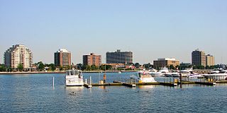
Sarnia is a city in Lambton County, Ontario, Canada. It had a 2021 population of 72,047, and is the largest city on Lake Huron. Sarnia is located on the eastern bank of the junction between the Upper and Lower Great Lakes, where Lake Huron flows into the St. Clair River in the Southwestern Ontario region, which forms the Canada–United States border, directly across from Port Huron, Michigan.

<span class="mw-page-title-main">Chatham-Kent</span> Municipality in Ontario, Canada

Chatham-Kent is a single-tier municipality in Southwestern Ontario, Canada. It is mostly rural, and its population centres are Chatham, Wallaceburg, Tilbury, Blenheim, Ridgetown, Wheatley and Dresden. The current Municipality of Chatham-Kent was created in 1998 by the amalgamation of Blenheim, Bothwell, Camden, the City of Chatham, the Township of Chatham, Dover, Dresden, Erie Beach, Erieau, Harwich, Highgate, Howard, Orford, Raleigh, Ridgetown, Duart, Thamesville, Tilbury East, Tilbury, Wallaceburg, Wheatley and Zone.

<span class="mw-page-title-main">Dryden, Ontario</span> City in Ontario, Canada

Dryden is the second-largest city in the Kenora District of Northwestern Ontario, Canada, located on Wabigoon Lake. It is the least populous community in Ontario incorporated as a city. The City of Dryden had a population of 7,749 and its population centre had a population of 5,586 in 2016.

<span class="mw-page-title-main">County of Brant</span> City in Ontario, Canada

The County of Brant is a single-tier municipality in the Canadian province of Ontario. Although it retains the word "county" in its name, the municipality is a single-tier municipal government and has no upper tier. The County of Brant has service offices in Burford, Paris, Oakland, Onondaga and St. George. The largest population centre is Paris.

In Canada, an Indian reserve is defined by the Indian Act as a "tract of land, the legal title to which is vested in His Majesty, that has been set apart by His Majesty for the use and benefit of a band." Reserves are areas set aside for First Nations, one of the major groupings of Indigenous peoples in Canada, after a contract with the Canadian state, and are not to be confused with Indigenous peoples' claims to ancestral lands under Aboriginal title.

<span class="mw-page-title-main">Lambton County</span> County in Ontario, Canada

Lambton County is a county in Southwestern Ontario, Canada. It is bordered on the north by Lake Huron, which is drained by the St. Clair River, the county's western border and part of the Canada-United States border. To the south is Lake Saint Clair and Chatham-Kent. Lambton County's northeastern border follows the Ausable River and Parkhill Creek north until it reaches Lake Huron at the beach community of Grand Bend. The county seat is in the Town of Plympton-Wyoming.

<span class="mw-page-title-main">Chippewas of Kettle and Stony Point First Nation</span> Ingidenous Reserve in Ontario, Canada

Kettle & Stony Point First Nation comprises the Kettle Point reserve and Stony Point Reserve, both located approximately 35 kilometres (22 mi) northeast of Sarnia, Ontario, Canada, on the southern shore of Lake Huron. The reserves serve as the land base for the Chippewas (Anishnaabeg) of Kettle and Stony Point First Nation.

<span class="mw-page-title-main">Sarnia—Lambton (federal electoral district)</span> Federal electoral district in Ontario, Canada

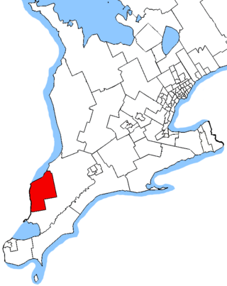
Sarnia—Lambton is a federal electoral district in Ontario, Canada, that has been represented in the House of Commons of Canada since 1968. It is located in the area of the city of Sarnia, in the southwest corner of the province of Ontario.

Neskantaga First Nation is a remote Oji-Cree First Nation band government in the northern reaches of the Canadian province of Ontario, situated along the shore of Attawapiskat Lake in the District of Kenora.

<span class="mw-page-title-main">Zhiibaahaasing First Nation</span> Indian reserve in Ontario, Canada

Zhiibaahaasing First Nation is a First Nation band government in the Canadian province of Ontario. It is a member of the United Chiefs and Councils of Manitoulin.

<i>Chippewas of Sarnia Band v Canada</i> (AG)

Chippewas of Sarnia Band v Canada (AG), 2000 CanLII 16991, 51 OR (3d) 641; 195 DLR (4th) 135 was a decision of the Court of Appeal for Ontario concerning aboriginal title in Canada.

Ontario Minamata disease is a neurological syndrome caused by severe mercury poisoning. It occurred in the Canadian province of Ontario, in 1970, and severely affected two First Nation communities in Northwestern Ontario following consumption of local fish contaminated with mercury, and one First Nation in Southern Ontario due to illegal disposal of industrial chemical waste. The disease was named after the infamous case of severe mercury poisoning in the fishing community of Minamata, Japan, which became known as Minamata disease because it devastated only the residents of the community.

King's Highway 40, commonly referred to as Highway 40, is a provincially maintained highway in the southwestern portion of the Canadian province of Ontario. The 91.4-kilometre (56.8 mi) route links Chatham and Sarnia via Wallaceburg, following close to the St. Clair River. The southern terminus is at Highway 401 south of Chatham, while the northern terminus is at Highway 402 in Sarnia. The portion of Highway 40 between Highway 401 and north of Wallaceburg is within the municipality of Chatham-Kent, while the portion north of there is within Lambton County.

<span class="mw-page-title-main">Wahgoshig First Nation</span> Indian reserve in Ontario, Canada

Apitipi Anicinapek Nation, formerly known as Wahgoshig First Nation, is an Algonquin Anicinape community, located near Matheson in Cochrane District in northeastern Ontario, Canada. In January 2008, the First Nation had 270 people registered with the nation, of which their on-reserve population was 121.

<span class="mw-page-title-main">Fort William First Nation</span> First Nation reserve in Ontario, Canada

Fort William First Nation is an Ojibwa First Nation reserve in Ontario, Canada. The administrative headquarters for this band government is south of Thunder Bay. As of January 2008, the First Nation had a registered population of 1,798 people, of which their on-Reserve population was 832 people.

<span class="mw-page-title-main">Sagamok Anishnawbek First Nation</span> Indian reserve in Ontario, Canada

The Sagamok Anishnawbek First Nation, also known as Many Rivers Joining-Human Beings, is a First Nations band government located in Ontario, Canada. Sagamok's culture and language is Anishinabek and is made up of the Ojibwe, Odawa and Pottawatomi bands. The Sagamok occupy the Sagamok reserve approximately 120 kilometres west of Sudbury, Ontario, and have a population of approximately 1650.

Slate Falls Nation is an Ojibwe First Nation band government in Ontario. It has a settlement at Slate Falls in Kenora District, Ontario. As of 2016, the First Nation had a registered population of 241 people, of which the on-reserve population was 9.

<span class="mw-page-title-main">Environmental impact of the chemical industry in Sarnia</span>

Sarnia's "Chemical Valley" and the surrounding area are home to 62 facilities and refineries. A 2007 Ecojustice Canada report showed those industrial facilities located within 25 km of Sarnia, Ontario, Canada emitted more than 131,000 tonnes of air pollution in 2005.

<span class="mw-page-title-main">Corunna, Ontario</span> Community in St. Clair, Ontario, Canada

Corunna is an unincorporated community in St. Clair Township, Lambton County, Ontario, Canada. The site of the community was surveyed by William Beresford in 1823. The community is located approximately 13 kilometres (8.1 mi) south of Sarnia. The community experienced a significant population boom between the 1830s and 1850s, mainly attributed to Scotch-Irish immigration. The community serves as the location of Chemical Valley, a major petrochemical and plastics manufacturing facility.

References

  1. 1 2 "Census Profile, 2021 Census - Sarnia 45, Indian reserve (Census subdivision), Ontario and Lambton, County (Census division), Ontario". Canada 2021 Census . Statistics Canada. Archived from the original on 2024-04-30. Retrieved 2024-04-30.
  2. C. A. Mackenzie; A. Lockridge & M. Keith (2005). "Declining Sex Ratio in a First Nation Community". Environmental Health Perspectives. 113 (10): 1295–8. doi:10.1289/ehp.8479. PMC   1281269 . PMID   16203237.
  3. "Aamjiwnaang First Nations concerned about chemical exposure". CBC News. 2005-09-02. Archived from the original on 2010-05-02. Retrieved 2008-10-21.
  4. Mary Ann Colihan (1 April 2008). "Aboriginal Canadians, Chemical valley". Canadian Broadcasting Corporation. Archived from the original on 27 March 2012. Retrieved 28 March 2012.
  5. "Environmental Rights--Human Rights and Pollution in Sarnia's Chemical Valley" (PDF). University of victoria. 13 June 2011. Archived (PDF) from the original on 24 March 2012. Retrieved 28 March 2012.
  6. "Aamjiwnaang First Nation declares state of emergency over benzene levels". cbc.ca. 25 April 2024. Archived from the original on 28 April 2024. Retrieved 30 April 2024.
  7. "Ontario takes action against chemical plant after Aamjiwnaang First Nation residents fell ill". globalnews.ca. 19 April 2024. Archived from the original on 28 April 2024. Retrieved 30 April 2024.
  8. "2021 Community Profiles". 2021 Canadian Census . Statistics Canada. February 4, 2022. Retrieved 2022-04-27.
  9. "2016 Community Profiles". 2016 Canadian Census . Statistics Canada. August 12, 2021. Retrieved 9 July 2017.
  10. "2011 Community Profiles". 2011 Canadian Census . Statistics Canada. March 21, 2019. Retrieved 9 July 2017.
  11. "2006 Community Profiles". 2006 Canadian Census . Statistics Canada. August 20, 2019.
  12. "2001 Community Profiles". 2001 Canadian Census . Statistics Canada. July 18, 2021.
  13. Statistics Canada: 1996, 2001, 2006, 2011, 2016, 2021 census
  14. "In Conversation with Lisa Jackson". Immerse. March 2, 2020. Archived from the original on 15 March 2023. Retrieved 15 March 2023.
  15. Plain, Chris. "Current Chief" (PDF). Directory Administration. Archived (PDF) from the original on October 27, 2020. Retrieved August 26, 2020.
  16. Simon, June. "Band Manager" (PDF). Directory Administration. Archived (PDF) from the original on October 27, 2020. Retrieved August 26, 2020.
  17. Nahmabin, Carolyn. "Membership" (PDF). Directory Administration. Archived (PDF) from the original on October 27, 2020. Retrieved August 26, 2020.
  18. Plain, David D. (August 9, 2007). The Plains of Aamjiwnaang: Our History. Victoria, British Columbia. ISBN   978-1425122737. Archived from the original on August 9, 2020. Retrieved August 26, 2020.{{cite book}}: CS1 maint: location missing publisher (link)