Cameroon, officially the Republic of Cameroon, is a country in Central Africa. It shares boundaries with Nigeria to the west and north, Chad to the northeast, the Central African Republic to the east, and Equatorial Guinea, Gabon and the Republic of the Congo to the south. Its coastline lies on the Bight of Biafra, part of the Gulf of Guinea and the Atlantic Ocean. Due to its strategic position at the crossroads between West Africa and Central Africa, it has been categorized as being in both camps. Its nearly 27 million people speak 250 native languages, in addition to the national tongues of English and French, or both.
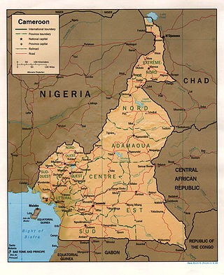
At 475,440 km2 (183,570 sq mi), Cameroon is the world's 53rd largest country. It is slightly larger than the nation of Sweden and the US state of California. It is comparable in size to Papua New Guinea. Cameroon's landmass is 472,710 km2 (182,510 sq mi), with 2,730 km2 (1,050 sq mi) of water.
Nigeria is a country in West Africa. It shares land borders with the Republic of Benin to the west, Chad and Cameroon to the east, and Niger to the north. Its coast lies on the Gulf of Guinea in the south and it borders Lake Chad to the northeast. Notable geographical features in Nigeria include the Adamawa Plateau, Mambilla Plateau, Jos Plateau, Obudu Plateau, the Niger River, Benue River, and Niger Delta.
Yola, meaning 'Great Plain' or 'Vast Plain Land', is a large city, capital city and administrative centre of Adamawa State, Nigeria. It is located on the Benue River, and it has a population of over 336,648 (2010). Yola is split into two parts. The old town of Yola where the Lamido resides is the traditional city and the new city of Jimeta is the administrative and commercial centre. They are generally referred to as Yola.

Adamawa State is a state in the North-East geopolitical zone of Nigeria, bordered by Borno to the northwest, Gombe to the west for 95 km, and Taraba to the southwest for about 366 km, while its eastern border forms part of the national border with Cameroon across the Atlantica Mountains for about 712 km. It takes its name from the historic emirate of Adamawa, with the emirate's old capital of Yola, serving as the capital city of Adamawa state. The state is one of the most heterogeneous in Nigeria, with over 100 indigenous ethnic groups. It was formed in 1991, when the former Gongola state was divided into Adamawa and Taraba states. Since it was carved out of the old Gongola State in 1991 by the General Ibrahim Badamsi Babangida military regime, Adamawa State has had 10 men, both military and civilian, controlling the levers of power, who played crucial roles in transforming the state into what it is today.

The North Region makes up 66,090 km2 of the northern half of The Republic of Cameroon. Neighbouring territories include the Far North Region to the north, the Adamawa Region to the south, Nigeria to the west, Chad to the east, and Central African Republic to the southeast. The city of Garoua is both the political and industrial capital. Garoua is Cameroon's third largest port, despite the fact that the Bénoué River upon which it relies is only navigable for short periods of the year.

Borno State is a state in the North-East geopolitical zone of Nigeria, bordered by Yobe to the west for about 421 km, Gombe to the southwest for 93 km, and Adamawa to the south while its eastern border forms part of the national border with Cameroon for about 426 km, its northern border forms part of the national border with Niger, for about 223 km mostly across the Komadougou-Yobe River, and its northeastern border forms all of the national border with Chad for 85 km, being the only Nigerian state to border three foreign countries. It takes its name from the historic emirate of Borno, with the emirate's old capital of Maiduguri serving as the capital city of Borno State. The state was formed in 1976 when the former North-Eastern State was broken up. It originally included the area that is now Yobe State, which became a distinct state in 1991.

The Mandara Mountains are a volcanic range extending about 190 km along the northern part of the Cameroon–Nigeria border, from the Benue River in the south to the north-west of Maroua in the north. The highest elevation is the summit of Mount Oupay, at 1,494 m (4,900 ft) above sea level.

The mountain reedbuck is an antelope found in mountainous areas of much of sub-Saharan Africa.

The Cameroon line is a 1,600 km (1,000 mi) long chain of volcanoes that includes islands in the Gulf of Guinea and mountains on the African mainland, from Mount Cameroon on the coast towards Lake Chad on the northeast. They form a natural border between eastern Nigeria and the West Region of Cameroon. The islands, which span the equator, have tropical climates and are home to many unique plant and bird species. The mainland mountain regions are much cooler than the surrounding lowlands, and also contain unique and ecologically important environments.

The Cameroonian Highlands forests, also known as the Cameroon Highlands forests, are a montane tropical moist broadleaf forest ecoregion located on the range of mountains that runs inland from the Gulf of Guinea and forms the border between Cameroon and Nigeria. This is an area of forest and grassland which has become more populous as land is cleared for agriculture.

The wildlife of Nigeria consists of the flora and fauna of this country in West Africa. Nigeria has a wide variety of habitats, ranging from mangrove swamps and tropical rainforest to savanna with scattered clumps of trees. About 290 mammal species and 940 bird species have been recorded in the country.
Sclerophrys gracilipes is a species of toad in the family Bufonidae. It is found in southeastern Nigeria and east- and southward to southern Cameroon, Equatorial Guinea, Gabon, northern Republic of the Congo, and northern and northeastern Democratic Republic of the Congo. It is also likely to occur in southwestern Central African Republic and in the Cabinda Enclave of Angola. The holotype was collected from the Benito River in what was then French Congo. Common name French Congo toad has been coined for it.

Sclerophrys regularis, commonly known as the African common toad, square-marked toad, African toad, Egyptian toad, African bouncing toad and Reuss's toad, is a species of toad in the family Bufonidae. It is found widely in the Subsaharan Africa, with its range extending to the oases in Algeria and Libya as well as to northern Nilotic Egypt. Specifically, it is found in Angola, Benin, Burkina Faso, Cameroon, Cape Verde, Central African Republic, Chad, Republic of the Congo, Democratic Republic of the Congo, Ivory Coast, Egypt, Ethiopia, Gabon, Ghana, Guinea, Guinea-Bissau, Kenya, Liberia, Mali, Niger, Nigeria, Rwanda, Senegal, Sierra Leone, Sudan, and Uganda.
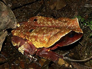
The African giant toad, Congo toad, or Cameroon toad is a species of toad in the family Bufonidae. It is found in Cameroon, Central African Republic, Republic of the Congo, Democratic Republic of the Congo, Ivory Coast, Equatorial Guinea, Gabon, Ghana, Nigeria, possibly Liberia, and possibly Sierra Leone. The toad's natural habitats are subtropical or tropical moist lowland forests, freshwater marshes, intermittent freshwater marshes, plantations, and heavily degraded former forest. While it is a "least concern" species, it is threatened by habitat loss.
Leptopelis nordequatorialis, also known as the West Cameroon forest treefrog, is a species of frog in the family Arthroleptidae. It is found in central and western Cameroon and eastern Nigeria. It is closely related to Leptopelis anchietae and Leptopelis oryi.

The Cameroonian forest shrew is a species of mammal in the family Soricidae. It is found in the Montane forests of Western Cameroon around Mount Oku and Lake Manengouba, and in Southeastern Nigeria in the Gotel Mountains or Adamawa Plateau.
The Lutheran Church of Christ in Nigeria (LCCN) is a major Lutheran denomination in Nigeria, a member of the Lutheran World Federation (LWF).
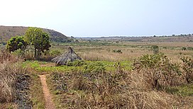
The Ngel Nyaki Forest Reserve, whose site is historically known as Majang, is situated on the Mambilla Plateau in North East Nigeria, covering 46 km2. It can be reached on foot from Yelwa village past the Mayo Jigawal, from where it is less than half an hour’s walk to the upper edge of the forest. The elevation ranges from 1,400 metres (4,593 ft) to 1,600 metres (5,249 ft). Ngel Nyaki was formally gazetted a local authority Forest Reserve under Gashaka - Mambilla Native Authority Forest order of April 1969, but presently it is under the management of the Taraba State Government and the Nigerian Conservation Foundation (NCF), with the Nigerian Montane Forest Project (NMFP) as a project partner.
Herder–farmer conflicts in Nigeria are a series of disputes over arable land resources across Nigeria between the mostly-Muslim Fulani herders and the mostly-Christian non-Fulani farmers. The conflicts have been especially prominent in the Middle Belt since the return of democracy in 1999. More recently, they have deteriorated into attacks on farmers by Fulani herdsmen.