Ais people

Last updated
Approximate territory of the Ais tribe in the late 17th century FLMap-Ais tribe.PNG
Approximate territory of the Ais tribe in the late 17th century

The Ais or Ays were a Native American people of eastern Florida. Their territory included coastal areas and islands from approximately Cape Canaveral to the Indian River. [1] The Ais chiefdom consisted of a number of towns, each led by a chief who was subordinate to the paramount chief of Ais; the Indian River was known as the "River of Ais" to the Spanish. [2] The Ais language has been linked to the Chitimacha language by linguist Julian Granberry, who points out that "Ais" means "the people" in the Chitimacha language. [3] The Ais were hunter-gatherers and food was plentiful. They ate fish, turtle, shellfish, cocoplums, sabal palm berries and other gathered fruits. [4] Prior to contact with European colonizers, the Ais population had grown to several hundred thousand and may have flourished for over 10,000 years. [5]

Contents

A burial mound, used by the Ais tribe for 500 to 1,000 years rises about twenty feet in Old Fort Park on Indian River Drive in Fort Pierce. This location later became an Army fort used during the Second Seminole War (1838–1842) and it may be the location of a Spanish settlement, mission and military outpost dating back to 1567. The burial mound is several hundred feet around. The Indian River (called the "Rio de Ais" by the Spanish colonizers) flows by within sight. [5]

The best single source for information on the Ais at the end of the 17th century is Jonathan Dickinson's Journal, in which he makes observations on their appearance, diet, and customs. Dickinson and his party were shipwrecked, and spent several weeks among the Ais in 1696. By Dickinson's account, the chief of the town of Jece, near present-day Sebastian, [6] was paramount to all of the coastal towns from the Jaega town of Jobe (at Jupiter Inlet) in the south to approximately Cape Canaveral in the north (that is, the length of the River of Ais). [7]

The Ais had already had considerable contact with Europeans by this time. The Spanish became acquainted with the Ais in middle of the 16th century. In 1566 Pedro Menéndez de Avilés, founder of St. Augustine, Florida, established a fort and mission at an Ais town, which the Spanish called Santa Lucía. [8] After the Ais attacked the fort, killing 23 of the soldiers, the Spanish abandoned the fort and mission. [9] Oathaqua was a major chief of the Ais. Governor Mendez de Canco reported in 1597 that this chief led more people than any other tribe. [4]

Spain eventually established some control over the coast; at first, the Ais considered them friends (comerradoes) and non-Spanish Europeans as enemies. A number of Ais men learned some Spanish, and a patrol of Spanish soldiers from St. Augustine arrived in Jece while the Dickinson party was there. One Ais man in Jece had been taken away by the English to work as a diver on a wreck east of Cuba. He got away when the ship put in for water in Cuba, and made his way back to his home via Havana and St. Augustine.

Pedro's bluff

In December of 1571, Pedro Menéndez de Avilés was sailing from Florida to Havana with two frigates when, as he tells it,

I was wrecked at Cape Canaveral because of a storm which came upon me, and the other boat was lost fifteen leagues further on in the Bahama Channel, in a river they call the Ais, because the cacique is so called. I, by a miracle reached the fort of St. Augustine with seventeen persons I was taking with me. Three times the Indians gave the order to attack me, and the way I escaped them was by ingenuity and arousing fear in them, telling them that behind me many Spaniards were coming who would slay them if they found them. [10]

Enslavement, war, and disease

In 1605, Governor Pedro de Ibarra sent a soldier, Álvaro Mexía, on a diplomatic mission to the Ais nation. The mission was a success; the Ais agreed to care for shipwrecked sailors for a ransom, and Mexía completed a map of the Indian River area with their help. [11] Numerous European artifacts from shipwrecks have been found in Ais settlements. When the Dickinson party reached the town, there was already in Jece another group of English from a shipwreck. European and African survivors of shipwrecks were fairly common along the coast.[ citation needed ] The Ais also traded with St. Augustine. Dickinson reports that one man of Jece had approximately five pounds of ambergris; he "boasted that when he went for Augustine with that, he would purchase of the Spaniards a looking-glass, an axe, a knife or two, and three or four mannocoes (which is about five or six pounds) of tobacco." [12]

Shortly after 1700, settlers in the Province of Carolina and their Indian allies started raiding the Ais, killing some and carrying captives to Charles Town to be sold as slaves. In 1743, the Spanish established a short-lived mission on Biscayne Bay (in the area of present-day Miami). The priests assigned to that mission reported the presence of people they called "Santa Luces", perhaps a name for the Ais derived from "Santa Lucia", somewhere to the north of Biscayne Bay. [13]

After 1703 the Ais were absorbed into the Costas tribe. Their numbers had diminished to 137 individuals by 1711. Diseases brought by the Europeans eradicated the remaining Ais/Costas by the mid-1740’s. [4] The Ais disappear from area records after 1760. [5]

Diet

Dickinson stated that the Ais "neither sow nor plant any manner of thing whatsoever," [14] but fished and gathered palmetto, cocoplum and seagrape berries. Dickinson described the fishing technique of the neighboring Jaega people of Jobe thus:

[T]he Casseekey [of Jobe] ... sent his son with his striking staff to the inlet to strike fish for us; which was performed with great dexterity; for some of us walked down with him, and though we looked very earnestly when he threw his staff from him could not see a fish at which time he saw it, and brought it onshore on the end of his staff. Sometimes he would run swiftly pursuing a fish, and seldom missed when he darted at him. In two hours time he got as many fish as would serve twenty men[.] [15]

The Ais boiled their fish, and ate them from 'platters' of palmetto leaf:

About noon was some fish brought us on small palmetto leaves, being boiled with scales, head and gills, and nothing taken from then [sic] but the gut[.] [16]

Dickinson also recorded a gift of clams to his wife:

This day the Cassekey [of Jece] ... made presents to some of us, especially to my wife; he gave her a parcel of shellfish, which are known by the name of clams; one or two he roasted and gave her, showing that she must serve the rest so, and eat them. [17]

The Ais dried some of the berries they gathered for future use:

This week we observed that great baskets of dried berries were brought in from divers towns and delivered to the king or Young Caseekey [of Jece.] [18]

Dickinson does not say anything about the Ais hunting, but they used deer skins. The neighboring Jaega people of Jobe gave the Dickinson party a hog they had killed. [19]

Clothing

The Ais men wore a "loincloth" of woven palm leaves. Dickinson describes this as:

being a piece of platwork of straws wrought of divers colors and of a triangular figure, with a belt of four fingers broad of the same wrought together, which goeth about the waist and the angle of the other having a thing to it, coming between the legs, and strings to the end of the belt; all three meeting together are fastened behind by a horsetail, or a bunch of silkgrass exactly resembling it, of a flaxen color, this being all of the apparel or covering that the men wear. [20]

He has little to say on how the women dressed, recording only that his wife and female slaves were given "raw deer skins" with which to cover themselves after their European clothing had been taken away. [21] Women of the Tequesta tribe, to the south of the Ais, were reported to wear "shawls" made of woven palm leaves, and "skirts” made from draped fibers from the Spanish dagger (yucca), similar to the "grass" skirts of Hawai'i.

Housing

Dickinson states that the town of Jece "stood about half a mile from the seashore within the land on the sound, being surrounded with a swamp, in which grew white mangrove trees, which hid the town from the sea." [22]

Dickinson describes the cacique's house in Santa Lucea as "about forty foot long and twenty-five foot wide, covered with palmetto leaves both top and sides. There was a range of cabins, or a barbecue on one side and two ends. At the entering on one side of the house a passage was made of benches on each side leading to the cabins." [21]

The Mayaca, who lived along the upper St. Johns River south of Lake George, appear to have spoken a language related to that of the Ais. The Surruque to the north and the Jaega to the south were politically subordinate to the Ais.

Ais Island name proposal

A proposal to name the barrier island separating the Indian River Lagoon from the Atlantic Ocean "Ponce de León Island" resulted in a counter-proposal to name it "Ais Island". As of December 2012, the United States Board on Geographic Names has rejected both names for the island. [23]

Notes

  1. Donald B. Ricky (1 January 1998). The Encyclopedia of Florida Indians: Tribes, Nations, and People of the Woodlands Area. North American Book Dist LLC. pp. 72–73. ISBN   978-0-403-09952-8 . Retrieved 29 December 2011.
  2. Survey of Indian River Archaeology, Yale University Publications in Anthropology : No. 45, Irving Rouse. ISBN   978-0-404-15668-8
  3. Granberry, Julian (2011). The Calusa: Linguistic and Cultural Relationships. Tuscaloosa, Alabama: The University of Alabama Press. p. 47. ISBN   978-0-8173-1751-5.
  4. 1 2 3 "Early Native Americans | St. Lucie Historical Society" . Retrieved 2023-01-22.
  5. 1 2 3 "Ais Indians Tribe: Explore the native Americans of Florida". www.floridiannature.com. Retrieved 2023-01-22.
  6. "Florida anthropologist". ufdc.ufl.edu. Retrieved 2015-11-18.
  7. Andrews and Andrews:29, 31, 34
  8. Milanich:156
  9. Gannon:44
  10. Rouse, Irving (1981). Survey of Indian River Archaeology. Yale University Publications in Anthropology 45. ISBN   978-0-404-15668-8.
  11. Rouse, Irving (1981). Survey of Indian River Archaeology. Yale University Publications in Anthropology pg. 271. ISBN   978-0-404-15668-8.
  12. Andrews and Andrews:28-29, 39-43
  13. Sturtevant
    Milanich:156
  14. Andrew and Andrew:36
  15. Andrews and Andrews, p.13.
  16. Andrews and Andrews:25
  17. Andrews and Andrews:25-26
  18. Andrews and Andrews:39
  19. Andrews and Andrews:10, 23
  20. Andrews and Andrews:23-4
  21. 1 2 Andrews and Andrews:23
  22. Andrews and Andrews:29
  23. Neale, Rick (December 5, 2012). "Feds reject moniker for Brevard's unnamed barrier island". Florida Today. Retrieved 9 November 2013.

Related Research Articles

<span class="mw-page-title-main">Cape Canaveral</span> Cape on the Atlantic coast of Florida in the United States

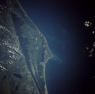
Cape Canaveral is a cape in Brevard County, Florida, in the United States, near the center of the state's Atlantic coast. Officially Cape Kennedy from 1963 to 1973, it lies east of Merritt Island, separated from it by the Banana River. It is part of a region known as the Space Coast, and is the site of the Cape Canaveral Space Force Station. Since many U.S. spacecraft have been launched from both the station and the Kennedy Space Center on adjacent Merritt Island, the two are sometimes conflated with each other.

<span class="mw-page-title-main">Calusa</span> Native American people

The Calusa were a Native American people of Florida's southwest coast. Calusa society developed from that of archaic peoples of the Everglades region. Previous indigenous cultures had lived in the area for thousands of years.

<span class="mw-page-title-main">Pedro Menéndez de Avilés</span> Spanish explorer and governor (1519–1574)

Pedro Menéndez de Avilés was a Spanish admiral, explorer and conquistador from Avilés, in Asturias, Spain. He is notable for planning the first regular trans-oceanic convoys, which became known as the Spanish treasure fleet, and for founding St. Augustine, Florida, in 1565. This was the first successful European settlement in La Florida and the most significant city in the region for nearly three centuries.

Tocobaga was the name of a chiefdom, its chief, and its principal town during the 16th century. The chiefdom was centered around the northern end of Old Tampa Bay, the arm of Tampa Bay that extends between the present-day city of Tampa and northern Pinellas County. The exact location of the principal town is believed to be the archeological Safety Harbor site, which gives its name to the Safety Harbor culture, of which the Tocobaga are the most well-known group.

<span class="mw-page-title-main">Spanish Florida</span> Former Spanish possession in North America (1513–1763; 1783–1821)

Spanish Florida was the first major European land claim and attempted settlement in North America during the European Age of Discovery. La Florida formed part of the Captaincy General of Cuba, the Viceroyalty of New Spain, and the Spanish Empire during Spanish colonization of the Americas. While its boundaries were never clearly or formally defined, the territory was initially much larger than the present-day state of Florida, extending over much of what is now the southeastern United States, including all of present-day Florida plus portions of Georgia, South Carolina, North Carolina, Alabama, Mississippi, and the Florida Parishes of Louisiana. Spain's claim to this vast area was based on several wide-ranging expeditions mounted during the 16th century. A number of missions, settlements, and small forts existed in the 16th and to a lesser extent in the 17th century; they were eventually abandoned due to pressure from the expanding English and French colonial settlements, the collapse of the native populations, and the general difficulty in becoming agriculturally or economically self-sufficient. By the 18th century, Spain's control over La Florida did not extend much beyond a handful of forts near St. Augustine, St. Marks, and Pensacola, all within the boundaries of present-day Florida.

Jonathan Dickinson (1663–1722) was a merchant from Port Royal, Jamaica who was shipwrecked on the southeast coast of Florida in 1696, along with his family and the other passengers and crew members of the ship. He wrote about their experiences. The party was held captive by Jobe ("Hoe-bay") Indians for several days, and then was allowed to travel by small boat and on foot the 230 miles up the coast to Saint Augustine. The party was subjected to harassment and physical abuse at almost every step of the journey to Saint Augustine. Five members of the party died from exposure and starvation on the way.

<span class="mw-page-title-main">Jaega</span> Native American chiefdom in Florida, US

The Jaega were Native Americans living in a chiefdom of the same name, which included the coastal parts of present-day Martin County and northern Palm Beach County, Florida at the time of initial European contact, and until the 18th century. The name Jobé, or Jové, has been identified as a synonym of Jaega, a sub-group of the Jaega, or a town of the Jaega.

<span class="mw-page-title-main">Potano</span> Native American chiefdom in Florida, US

The Potano tribe lived in north-central Florida at the time of first European contact. Their territory included what is now Alachua County, the northern half of Marion County and the western part of Putnam County. This territory corresponds to that of the Alachua culture, which lasted from about 700 until 1700. The Potano were among the many tribes of the Timucua people, and spoke a dialect of the Timucua language.

<span class="mw-page-title-main">Mocama</span> Indigenous people of Florida and Georgia, US

The Mocama were a Native American people who lived in the coastal areas of what are now northern Florida and southeastern Georgia. A Timucua group, they spoke the dialect known as Mocama, the best-attested dialect of the Timucua language. Their heartland extended from about the Altamaha River in Georgia to south of the mouth of the St. John's River, covering the Sea Islands and the inland waterways, Intracoastal. and much of present-day Jacksonville. At the time of contact with Europeans, there were two major chiefdoms among the Mocama, the Saturiwa and the Tacatacuru, each of which evidently had authority over multiple villages. The Saturiwa controlled chiefdoms stretching to modern day St. Augustine, but the native peoples of these chiefdoms have been identified by Pareja as speaking Agua Salada, which may have been a distinct dialect.

<span class="mw-page-title-main">Tequesta</span> Native American tribe

The Tequesta, also Tekesta, Tegesta, Chequesta, Vizcaynos, were a Native American tribe. At the time of first European contact they occupied an area along the southeastern Atlantic coast of Florida. They had infrequent contact with Europeans and had largely migrated by the middle of the 18th century.

The Surruque people lived along the middle Atlantic coast of Florida during the 16th and 17th centuries. They may have spoken a dialect of the Timucua language, but were allied with the Ais. The Surruque became clients of the Spanish government in St. Augustine, but were not successfully brought into the Spanish mission system.

Acuera was the name of both an indigenous town and a province or region in central Florida during the 16th and 17th centuries. The indigenous people of Acuera spoke a dialect of the Timucua language. In 1539 the town first encountered Europeans when it was raided by soldiers of Hernando de Soto's expedition. French colonists also knew this town during their brief tenure (1564–1565) in northern Florida.

The indigenous people of the Everglades region arrived in the Florida peninsula of what is now the United States approximately 14,000 to 15,000 years ago, probably following large game. The Paleo-Indians found an arid landscape that supported plants and animals adapted to prairie and xeric scrub conditions. Large animals became extinct in Florida around 11,000 years ago. Climate changes 6,500 years ago brought a wetter landscape. The Paleo-Indians slowly adapted to the new conditions. Archaeologists call the cultures that resulted from the adaptations Archaic peoples. They were better suited for environmental changes than their ancestors, and created many tools with the resources they had. Approximately 5,000 years ago, the climate shifted again to cause the regular flooding from Lake Okeechobee that gave rise to the Everglades ecosystems.

<span class="mw-page-title-main">Timucua</span> Native American people

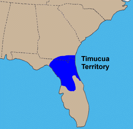
The Timucua were a Native American people who lived in Northeast and North Central Florida and southeast Georgia. They were the largest indigenous group in that area and consisted of about 35 chiefdoms, many leading thousands of people. The various groups of Timucua spoke several dialects of the Timucua language. At the time of European contact, Timucuan speakers occupied about 19,200 square miles (50,000 km2) in the present-day states of Florida and Georgia, with an estimated population of 200,000. Milanich notes that the population density calculated from those figures, 10.4 per square mile (4.0/km2) is close to the population densities calculated by other authors for the Bahamas and for Hispaniola at the time of first European contact. The territory occupied by Timucua speakers stretched from the Altamaha River and Cumberland Island in present-day Georgia as far south as Lake George in central Florida, and from the Atlantic Ocean west to the Aucilla River in the Florida Panhandle, though it reached the Gulf of Mexico at no more than a couple of points.

The indigenous peoples of Florida lived in what is now known as Florida for more than 12,000 years before the time of first contact with Europeans. However, the indigenous Floridians living east of the Apalachicola River had largely died out by the early 18th century. Some Apalachees migrated to Louisiana, where their descendants now live; some were taken to Cuba and Mexico by the Spanish in the 18th century, and a few may have been absorbed into the Seminole and Miccosukee tribes.

<span class="mw-page-title-main">Saturiwa</span> Timucua chiefdom in Spanish Florida

The Saturiwa were a Timucua chiefdom centered on the mouth of the St. Johns River in what is now Jacksonville, Florida. They were the largest and best attested chiefdom of the Timucua subgroup known as the Mocama, who spoke the Mocama dialect of Timucuan and lived in the coastal areas of present-day northern Florida and southeastern Georgia. They were a prominent political force in the early days of European settlement in Florida, forging friendly relations with the French Huguenot settlers at Fort Caroline in 1564 and later becoming heavily involved in the Spanish mission system.

<span class="mw-page-title-main">Agua Dulce people</span> Timucua tribe in Spanish Florida

The Agua Dulce or Agua Fresca (Freshwater) were a Timucua people of northeastern Florida. They lived in the St. Johns River watershed north of Lake George, and spoke a dialect of the Timucua language also known as Agua Dulce.

Tacatacuru was a Timucua chiefdom located on Cumberland Island in what is now the U.S. state of Georgia in the 16th and 17th centuries. It was one of two chiefdoms of the Timucua subgroup known as the Mocama, who spoke the Mocama dialect of Timucuan and lived in the coastal areas of southeastern Georgia and northern Florida.

<span class="mw-page-title-main">Álvaro Mexía</span> Spanish cartographer and explorer

Alvaro Mexia was a 17th-century Spanish explorer and cartographer of the east coast of Florida. Mexia was stationed in St Augustine and was given a diplomatic mission to the native populations living south of St. Augustine and in the Cape Canaveral area. This mission resulted in a "Period of Friendship" between the Spanish and the Ais native population.

San Buenaventura de Potano was a Spanish mission near Orange Lake in southern Alachua County or northern Marion County, Florida, located on the site where the town of Potano had been located when it was visited by Hernando de Soto in 1539. The Richardson/UF Village Site (8AL100), in southern Alachua County, has been proposed as the location of the town and mission.

References

See also