
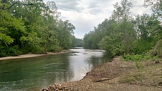
Albert Pike Recreation Area is a recreational area located in the Ouachita National Forest about 6 miles north of Langley, Arkansas, in southern Montgomery County, featuring swimming and camping areas on the Little Missouri River.
Albert Pike Recreation Area is a recreational area located in the Ouachita National Forest about 6 miles north of Langley, Arkansas, in southern Montgomery County, featuring swimming and camping areas on the Little Missouri River.
During the night of June 10–11, 2010 a flash flood along Little Missouri River killed 20 people in the campgrounds of the Albert Pike Recreation Area. [1] In a matter of less than four hours water rose from three feet to over twenty-three feet. Since that time the U.S. Forest Service has closed the site for further evaluation. [2] [3]
On July 20, 2018, the United States Court of Appeals for the Eighth Circuit upheld the dismissal of a lawsuit against the federal government relating to this incident, on the grounds that the suit was barred by the Federal Tort Claims Act. To wit, the Court ruled that the government could not be considered negligent in allowing visitors to camp overnight on a previously-known 100-year floodplain (occupied by Loop D, the site of most of the deaths), since "camping within a 100-year floodplain is not an uncommon recreational activity" and the June 10–11 flood was unquestionably a catastrophic 500-year flood event that would have posed a "ultra-hazardous condition" regardless of any attempts to mitigate or warn against the known 100-year flood risk at Loop D. [4]

Pike County is a county located in the U.S. state of Arkansas. As of the 2010 census, the population was 11,291. The county seat is Murfreesboro. Pike County is Arkansas's 25th county, formed on November 1, 1833, and named for Lieutenant Zebulon Pike, the explorer who discovered Pikes Peak. It is an alcohol prohibition or dry county. The current judge is Dewight Mack.

Arkadelphia is a city in Clark County, Arkansas, United States. As of the 2010 census, the population was 10,714. The city is the county seat of Clark County. It is situated at the foothills of the Ouachita Mountains. Two universities, Henderson State University and Ouachita Baptist University, are located here. Arkadelphia was incorporated in 1857.

Glenwood is a city in Pike and Montgomery counties in Arkansas, United States. As of the 2020 census, its population was 2,068. The community is located along the Caddo River in the Ouachita Mountains.

The Ouachita National Forest is a vast congressionally-designated National Forest that lies in the western portion of Arkansas and portions of extreme-eastern Oklahoma, USA.

The Little Missouri River, or Little Mo, is a 147-mile-long (237 km) waterway that runs from the Ouachita Mountains of southwest Arkansas into the rolling hills area in the surrounding countryside.
The Caddo River is a tributary of the Ouachita River in the U.S. state of Arkansas. The river is about 82 miles (132 km) long.

The Conecuh National Forest in southern Alabama covers 83,000 acres (340 km2), along the Alabama - Florida line in Covington and Escambia counties. Topography is level to moderately sloping, broad ridges with stream terraces and broad floodplains.
The Missouri National Recreational River is a National Recreational River located on the border between Nebraska and South Dakota. The designation was first applied in 1978 to a 59-mile section of the Missouri River between Gavins Point Dam and Ponca State Park. In 1991, an additional 39-mile section between Fort Randall Dam and Niobrara, Nebraska, was added to the designation. These two stretches of the Missouri River are the only parts of the river between Montana and the mouth of the Missouri that remain undammed or unchannelized. The last 20 miles of the Niobrara River and 6 miles of Verdigre Creek were also added in 1991.

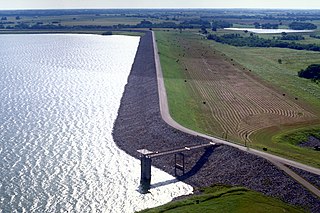
Narrows Dam is a dam located 6 miles north of Murfreesboro, Arkansas, that impounds the water of the Little Missouri River (Arkansas) to create Lake Greeson. Narrows Dam was authorized as a flood control and hydroelectric power project by the Flood Control Act of 1941. The dam is a feature of the comprehensive plan for the Ouachita River Basin. Lake Greeson is operated for hydroelectric power, recreation, and flood control.

Lake Ouachita is a reservoir created by the damming of the Ouachita River by Blakely Mountain Dam.

Ouachita National Recreation Trail is a 223-mile (359 km) long, continuous hiking trail through the Ouachita Mountains of Oklahoma and Arkansas. It is the longest backpacking trail in the Ouachita National Forest, spanning 192 miles across its length. Approximately 177 miles of the trail is in Arkansas and 46 miles of the trail is in Oklahoma. The trail is used by hikers, backpackers, hunters, and mountain bikers. It is a non-motorized single track trail open only to foot traffic and partially open to mountain bicycles. Segments opened to mountain bikes are from the western terminus of the Ouachita Trail at Talimena State Park to the Big Cedar trailhead on US Highway 259 at approximately Mile Marker (MM) 30.5 in Oklahoma, and from the Talimena Scenic Drive Trailhead at MM 54.1, east to Highway 7 at mile 160.4, north of Jessieville, Arkansas.
Winding Stair Mountain National Recreation Area is a United States national recreation area in the Ouachita National Forest. State Highway 1, known as the Talimena Scenic Byway in this area, bisects the recreation area. U. S. Highway 271 loops up through the summit. Winding Stair Mountain National Recreation Area and the nearby Upper Kiamichi River and Black Fork Mountain Wilderness areas were created by an act of Congress on October 18, 1988.

The Geography of Oklahoma encompasses terrain and ecosystems ranging from arid plains to subtropical forests and mountains. Oklahoma contains 10 distinct ecological regions, more per square mile than in any other state by a wide margin. It is situated in the Great Plains and U.S. Interior Highlands region near the geographical center of the 48 contiguous states. Usually considered part of the South Central United States, Oklahoma is bounded on the east by Arkansas and Missouri, on the north by Kansas, on the northwest by Colorado, on the far west by New Mexico, and on the south and near-west by Texas.

Waterloo State Recreation Area is the third-largest park in Michigan, encompassing over 21,000 acres (85 km2) of forest, lakes and wetlands. Located in northeast Jackson County and parts of Washtenaw County, the park is the largest in the Lower Peninsula of Michigan and features 4 campgrounds, 11 lakes, a nature center, and over 50 miles (80 km) of trails - some for horses, bicycles, hiking and cross-country skiing. Waterloo SRA includes the Black Spruce Bog Natural Area, a National Natural Landmark and borders the 11,000-acre (45 km2) Pinckney Recreation Area on the east and the 950-acre (3.8 km2) Phyllis Haehnle Memorial Audubon Sanctuary to the west. The land preserved by the park is not all contiguous and numerous private landholdings and roads run through the park area. The area is characterized by moraines, kettle lakes, swamps and bogs left by retreating glaciers after the last ice age. The park was created by the federal government during the Great Depression and is long-term leased to the state.
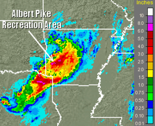
The 2010 Arkansas floods were flash floods that killed at least 20 people near Langley, Arkansas, United States, in the early morning of June 11, 2010. Heavy, localized rainfall from six to eight inches (150–200 mm) flooded the Little Missouri and Caddo rivers, sweeping through campsites in the Ouachita National Forest.
Womble Trail, located in the Ouachita National Forest in western Arkansas, United States, is a singletrack path running more than 37 miles from North Fork Lake to the Ouachita National Recreation Trail. The U.S. Forest Service trail is open for use by mountain bikers and hikers. Horses are not allowed. The nearest towns are Mount Ida and Oden.
Indian Nations National Scenic and Wildlife Area is a federally designated National Scenic Area within Ouachita National Forest 11 miles (18 km) south of Heavener, in Le Flore County, Oklahoma USA. The 41,051-acre (16,613 ha) scenic area is administered by the U.S. Forest Service. The scenic area includes the Homer L. Johnson Wildlife Management Area. There is also a 15-acre (6.1 ha) fishing lake atop Post Mountain, developed by the U. S. Forest Service during the 1930s, is included within the scenic area.
Lake Bardwell is a lake in Ellis County, Texas. The lake was constructed by the United States Army Corps of Engineers in 1965. Lake Bardwell is not used for military operations, and is accessible to the public for recreational purposes; it has seven facilities, but the state public ramp is closed.

Shady Lake Recreation Area is a campground and public recreation area in southwestern Ouachita National Forest, southwest of Mena, Arkansas and west of Glenwood, Arkansas. The area is oriented around Shady Lake, a body of water on the South Fork Saline River impounded by a dam built c. 1940 by the Civilian Conservation Corps (CCC). The area is administered by the United States Forest Service (USFS).

Highway 369 is a designation for three north–south state highways in Arkansas. All are maintained by the Arkansas Department of Transportation (ArDOT). One segment provides connectivity in the Ouachita Mountains, with the other two serving as short industrial access roads. The longest segment was designated in 1966 and extended thrice, with the two industrial access roads created in 1978 and 1980. All three segments are maintained by the Arkansas Department of Transportation (ArDOT).
| General | |
|---|---|
| National libraries | |
Coordinates: 34°22′31″N93°52′40″W / 34.37528°N 93.87778°W