
Orogeny is a mountain-building process that takes place at a convergent plate margin when plate motion compresses the margin. An orogenic belt or orogen develops as the compressed plate crumples and is uplifted to form one or more mountain ranges. This involves a series of geological processes collectively called orogenesis. These include both structural deformation of existing continental crust and the creation of new continental crust through volcanism. Magma rising in the orogen carries less dense material upwards while leaving more dense material behind, resulting in compositional differentiation of Earth's lithosphere. A synorogenic process or event is one that occurs during an orogeny.

The geology of the Appalachians dates back more than 1.1 billion years to the Mesoproterozoic era when two continental cratons collided to form the supercontinent Rodinia, 500 million years prior to the later development of the range during the formation of the supercontinent Pangea. The rocks exposed in today's Appalachian Mountains reveal elongate belts of folded and thrust faulted marine sedimentary rocks, volcanic rocks and slivers of ancient ocean floor – strong evidence that these rocks were deformed during plate collision. The birth of the Appalachian ranges marks the first of several mountain building plate collisions that culminated in the construction of the supercontinent Pangea with the Appalachians and neighboring Anti-Atlas mountains near the center. These mountain ranges likely once reached elevations similar to those of the Alps and the Rocky Mountains before they were eroded.

In geology, a fault is a planar fracture or discontinuity in a volume of rock across which there has been significant displacement as a result of rock-mass movements. Large faults within Earth's crust result from the action of plate tectonic forces, with the largest forming the boundaries between the plates, such as the megathrust faults of subduction zones or transform faults. Energy release associated with rapid movement on active faults is the cause of most earthquakes. Faults may also displace slowly, by aseismic creep.

The Taconic Mountains are a 150-mile-long sub-range of the Appalachian Mountains lying on the eastern border of New York State and adjacent New England. The range, which played a role in the history of geological science, is separated from the Berkshires and Green Mountains to the east by a series of valleys, principally those of the Housatonic River, Battenkill River and Otter Creek. The Taconics' highest point is Mount Equinox in Vermont at 3,840 feet (1,170 m); among many other summits are Dorset Mountain, Mount Greylock and Mount Everett.

The Acadian orogeny is a long-lasting mountain building event which began in the Middle Devonian, reaching a climax in the early Late Devonian. It was active for approximately 50 million years, beginning roughly around 375 million years ago, with deformational, plutonic, and metamorphic events extending into the Early Mississippian. The Acadian orogeny is the third of the four orogenies that formed the Appalachian orogen and subsequent basin. The preceding orogenies consisted of the Potomac and Taconic orogeny, which followed a rift/drift stage in the Late Neoproterozoic. The Acadian orogeny involved the collision of a series of Avalonian continental fragments with the Laurasian continent. Geographically, the Acadian orogeny extended from the Canadian Maritime provinces migrating in a southwesterly direction toward Alabama. However, the Northern Appalachian region, from New England northeastward into Gaspé region of Canada, was the most greatly affected region by the collision.

The Antler orogeny was a tectonic event that began in the early Late Devonian with widespread effects continuing into the Mississippian and early Pennsylvanian. Most of the evidence for this event is in Nevada but the limits of its reach are unknown. A great volume of conglomeratic deposits of mainly Mississippian age in Nevada and adjacent areas testifies to the existence of an important tectonic event, and implies nearby areas of uplift and erosion, but the nature and cause of that event are uncertain and in dispute. Although it is known as an orogeny, some of the classic features of orogeny as commonly defined such as metamorphism, and granitic intrusives have not been linked to it. In spite of this, the event is universally designated as an orogeny and that practice is continued here. This article outlines what is known and unknown about the Antler orogeny and describes three current theories regarding its nature and origin.
The geology of the Himalayas is a record of the most dramatic and visible creations of the immense mountain range formed by plate tectonic forces and sculpted by weathering and erosion. The Himalayas, which stretch over 2400 km between the Namcha Barwa syntaxis at the eastern end of the mountain range and the Nanga Parbat syntaxis at the western end, are the result of an ongoing orogeny — the collision of the continental crust of two tectonic plates, namely, the Indian Plate thrusting into the Eurasian Plate. The Himalaya-Tibet region supplies fresh water for more than one-fifth of the world population, and accounts for a quarter of the global sedimentary budget. Topographically, the belt has many superlatives: the highest rate of uplift, the highest relief, among the highest erosion rates at 2–12 mm/yr, the source of some of the greatest rivers and the highest concentration of glaciers outside of the polar regions. This last feature earned the Himalaya its name, originating from the Sanskrit for "the abode of the snow".

The Taconic orogeny was a mountain building period that ended 440 million years ago (Ma) and affected most of modern-day New England. A great mountain chain formed from eastern Canada down through what is now the Piedmont of the east coast of the United States. As the mountain chain eroded in the Silurian and Devonian periods, sediment spread throughout the present-day Appalachians and midcontinental North America.

The Caledonian orogeny was a mountain-building cycle recorded in the northern parts of the British Isles, the Scandinavian Caledonides, Svalbard, eastern Greenland and parts of north-central Europe. The Caledonian orogeny encompasses events that occurred from the Ordovician to Early Devonian, roughly 490–390 million years ago (Ma). It was caused by the closure of the Iapetus Ocean when the Laurentia and Baltica continents and the Avalonia microcontinent collided.
A klippe is a geological feature of thrust fault terrains. The klippe is the remnant portion of a nappe after erosion has removed connecting portions of the nappe. This process results in an outlier of exotic, often nearly horizontally translated strata overlying autochthonous strata.
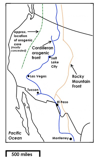
The Rocky Mountain Front is a somewhat unified geologic and ecosystem area in North America where the eastern slopes of the Rocky Mountains meet the plains. In 1983, the Bureau of Land Management called the Rocky Mountain Front "a nationally significant area because of its high wildlife, recreation, and scenic values". Conservationists Gregory Neudecker, Alison Duvall, and James Stutzman have described the Rocky Mountain Front as an area that warrants "the highest of conservation priorities" because it is largely unaltered by development and contains "unparalleled" numbers of wildlife.
Fault blocks are very large blocks of rock, sometimes hundreds of kilometres in extent, created by tectonic and localized stresses in Earth's crust. Large areas of bedrock are broken up into blocks by faults. Blocks are characterized by relatively uniform lithology. The largest of these fault blocks are called crustal blocks. Large crustal blocks broken off from tectonic plates are called terranes. Those terranes which are the full thickness of the lithosphere are called microplates. Continent-sized blocks are called variously microcontinents, continental ribbons, H-blocks, extensional allochthons and outer highs.
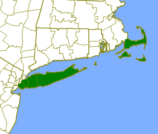
The Outer Lands is the prominent terminal moraine archipelagic region off the southern coast of New England in the United States. This eight-county region of Massachusetts, Rhode Island, and New York, comprises the peninsula of Cape Cod and the islands of Nantucket, Martha's Vineyard, the Elizabeth Islands, the Narragansett Bay Islands, Block Island, Long Island, and Staten Island, as well as surrounding islands and islets.

The geology of Norway encompasses the history of Earth that can be interpreted by rock types found in Norway, and the associated sedimentological history of soils and rock types.
The Sonoma orogeny was a period of mountain building in western North America. The exact age and structure of the Sonoma orogeny is controversial. The orogeny is generally thought to have occurred during the Permian / Triassic transition, around 250 million years ago, following the Late Devonian Antler orogeny. The Sonoma orogeny was one of a sequence of accretionary events along the Cordilleran margin, possibly caused by the closure of the basin between the island arc of Sonomia and the North American continent. Evidence of this event has been reported throughout western North America, but most distinctly in northwest Nevada.

Thin-skinned deformation is a style of deformation in plate tectonics at a convergent boundary which occurs with shallow thrust faults that only involves cover rocks, and not deeper basement rocks.

The geology of Massachusetts includes numerous units of volcanic, intrusive igneous, metamorphic and sedimentary rocks formed within the last 1.2 billion years. The oldest formations are gneiss rocks in the Berkshires, which were metamorphosed from older rocks during the Proterozoic Grenville orogeny as the proto-North American continent Laurentia collided against proto-South America. Throughout the Paleozoic, overlapping the rapid diversification of multi-cellular life, a series of six island arcs collided with the Laurentian continental margin. Also termed continental terranes, these sections of continental rock typically formed offshore or onshore of the proto-African continent Gondwana and in many cases had experienced volcanic events and faulting before joining the Laurentian continent. These sequential collisions metamorphosed new rocks from sediments, created uplands and faults and resulted in widespread volcanic activity. Simultaneously, the collisions raised the Appalachian Mountains to the height of the current day Himalayas.

The geology of North America is a subject of regional geology and covers the North American continent, the third-largest in the world. Geologic units and processes are investigated on a large scale to reach a synthesized picture of the geological development of the continent.

The geology of Sweden is the regional study of rocks, minerals, tectonics, natural resources and groundwater in the country. The oldest rocks in Sweden date to more than 2.5 billion years ago in the Precambrian. Complex orogeny mountain building events and other tectonic occurrences built up extensive metamorphic crystalline basement rock that often contains valuable metal deposits throughout much of the country. Metamorphism continued into the Paleozoic after the Snowball Earth glaciation as the continent Baltica collided with an island arc and then the continent Laurentia. Sedimentary rocks are most common in southern Sweden with thick sequences from the last 250 million years underlying Malmö and older marine sedimentary rocks forming the surface of Gotland.
The Golconda Thrust is a major oceanic terrane that was thrust over central and northern Nevada, North America, in possibly sometime between the Late Permian and the late Jurassic. It is considered equivalent to the Tobin thrust fault.
