
The Farallon Plate was an ancient oceanic plate. It formed one of the three main plates of Panthalassa, alongside the Izanagi Plate and the Phoenix Plate, which were connected by a triple junction. The Farallon Plate began subducting under the west coast of the North American Plate—then located in modern Utah—as Pangaea broke apart and after the formation of the Pacific Plate at the centre of the triple junction during the Early Jurassic. It is named for the Farallon Islands, which are located just west of San Francisco, California.
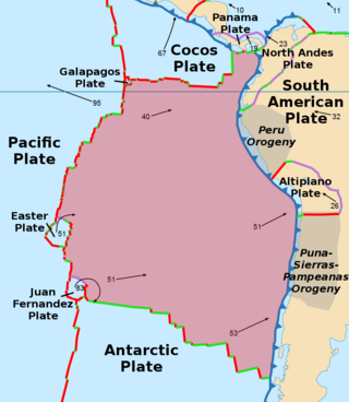
The Nazca Plate or Nasca Plate, named after the Nazca region of southern Peru, is an oceanic tectonic plate in the eastern Pacific Ocean basin off the west coast of South America. The ongoing subduction, along the Peru–Chile Trench, of the Nazca Plate under the South American Plate is largely responsible for the Andean orogeny. The Nazca Plate is bounded on the west by the Pacific Plate and to the south by the Antarctic Plate through the East Pacific Rise and the Chile Rise respectively. The movement of the Nazca Plate over several hotspots has created some volcanic islands as well as east–west running seamount chains that subduct under South America. Nazca is a relatively young plate both in terms of the age of its rocks and its existence as an independent plate having been formed from the break-up of the Farallon Plate about 23 million years ago. The oldest rocks of the plate are about 50 million years old.
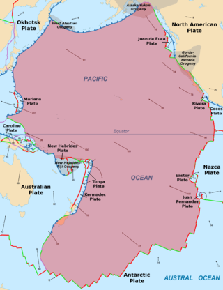
The Pacific Plate is an oceanic tectonic plate that lies beneath the Pacific Ocean. At 103 million km2 (40 million sq mi), it is the largest tectonic plate.

The Australian Plate is a major tectonic plate in the eastern and, largely, southern hemispheres. Originally a part of the ancient continent of Gondwana, Australia remained connected to India and Antarctica until approximately 100 million years ago when India broke away and began moving north. Australia and Antarctica had begun rifting by 96 million years ago and completely separated a while after this, some believing as recently as 45 million years ago, but most accepting presently that this had occurred by 60 million years ago.

The Kerguelen Plateau, also known as the Kerguelen–Heard Plateau, is an oceanic plateau and large igneous province (LIP) located on the Antarctic Plate, in the southern Indian Ocean. It is about 3,000 km (1,900 mi) to the southwest of Australia and is nearly three times the size of California. The plateau extends for more than 2,200 km (1,400 mi) in a northwest–southeast direction and lies in deep water.

The geology of Antarctica covers the geological development of the continent through the Archean, Proterozoic and Phanerozoic eons.
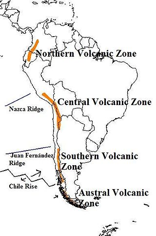
The Andean Volcanic Belt is a major volcanic belt along the Andean cordillera in Argentina, Bolivia, Chile, Colombia, Ecuador, and Peru. It is formed as a result of subduction of the Nazca Plate and Antarctic Plate underneath the South American Plate. The belt is subdivided into four main volcanic zones which are separated by volcanic gaps. The volcanoes of the belt are diverse in terms of activity style, products, and morphology. While some differences can be explained by which volcanic zone a volcano belongs to, there are significant differences within volcanic zones and even between neighboring volcanoes. Despite being a type location for calc-alkalic and subduction volcanism, the Andean Volcanic Belt has a broad range of volcano-tectonic settings, as it has rift systems and extensional zones, transpressional faults, subduction of mid-ocean ridges and seamount chains as well as a large range of crustal thicknesses and magma ascent paths and different amounts of crustal assimilations.

The geology of Chile is a characterized by processes linked to subduction, such as volcanism, earthquakes, and orogeny. The building blocks of Chile's geology were assembled during the Paleozoic Era when Chile was the southwestern margin of the supercontinent Gondwana. In the Jurassic, Gondwana began to split, and the ongoing period of crustal deformation and mountain building known as the Andean orogeny began. In the Late Cenozoic, Chile definitely separated from Antarctica, and the Andes experienced a significant rise accompanied by a cooling climate and the onset of glaciations.

The Chile Triple Junction is a geologic triple junction located on the seafloor of the Pacific Ocean off Taitao and Tres Montes Peninsula on the southern coast of Chile. Here three tectonic plates meet: the South American Plate, the Nazca Plate and the Antarctic Plate. This triple junction is unusual in that it consists of a mid-oceanic ridge, the Chile Rise, being subducted under the South American Plate at the Peru–Chile Trench. The Chile Triple Junction is the boundary between the Chilean Rise and the Chilean margin, where the Nazca, Antarctic, and South American plates meet at the trench.

Gondwana was a large landmass, sometimes referred to as a supercontinent. The remnants of Gondwana make up around two-thirds of today's continental area, including South America, Africa, Antarctica, Australia, Zealandia, Arabia, and the Indian Subcontinent.

The Nazca Ridge is a submarine ridge, located on the Nazca Plate off the west coast of South America. This plate and ridge are currently subducting under the South American Plate at a convergent boundary known as the Peru-Chile Trench at approximately 7.7 cm (3.0 in) per year. The Nazca Ridge began subducting obliquely to the collision margin at 11°S, approximately 11.2 Ma, and the current subduction location is 15°S. The ridge is composed of abnormally thick basaltic ocean crust, averaging 18 ±3 km thick. This crust is buoyant, resulting in flat slab subduction under Peru. This flat slab subduction has been associated with the uplift of Pisco Basin and the cessation of Andes volcanism and the uplift of the Fitzcarrald Arch on the South American continent approximately 4 Ma.
This is a list of articles related to plate tectonics and tectonic plates.

The Andean orogeny is an ongoing process of orogeny that began in the Early Jurassic and is responsible for the rise of the Andes mountains. The orogeny is driven by a reactivation of a long-lived subduction system along the western margin of South America. On a continental scale the Cretaceous and Oligocene were periods of re-arrangements in the orogeny. The details of the orogeny vary depending on the segment and the geological period considered.
The Antarctic Peninsula, roughly 1,000 kilometres (650 mi) south of South America, is the northernmost portion of the continent of Antarctica. Like the associated Andes, the Antarctic Peninsula is an excellent example of ocean-continent collision resulting in subduction. The peninsula has experienced continuous subduction for over 200 million years, but changes in continental configurations during the amalgamation and breakup of continents have changed the orientation of the peninsula itself, as well as the underlying volcanic rocks associated with the subduction zone.

The tectonic evolution of the Transantarctic Mountains appears to have begun when Antarctica broke away from Australia during the late Cretaceous and is ongoing, creating along the way some of the longest mountain ranges formed by rift flank uplift and associated continental rifting. The Transantarctic Mountains (TAM) separate East and West Antarctica. The rift system that formed them is caused by a reactivation of crust along the East Antarctic Craton. This rifting or seafloor spreading causes plate movement that results in a nearby convergent boundary which then forms the mountain range. The exact processes responsible for making the Transantarctic Mountains are still debated today. This results in a large variety of proposed theories that attempt to decipher the tectonic history of these mountains.

The East Antarctic Shield or Craton is a cratonic rock body that covers 10.2 million square kilometers or roughly 73% of the continent of Antarctica. The shield is almost entirely buried by the East Antarctic Ice Sheet that has an average thickness of 2200 meters but reaches up to 4700 meters in some locations. East Antarctica is separated from West Antarctica by the 100–300 kilometer wide Transantarctic Mountains, which span nearly 3,500 kilometers from the Weddell Sea to the Ross Sea. The East Antarctic Shield is then divided into an extensive central craton that occupies most of the continental interior and various other marginal cratons that are exposed along the coast.
Fueguino is a volcanic field in Chile. The southernmost volcano in the Andes, it lies on Tierra del Fuego's Cook Island and also extends over nearby Londonderry Island. The field is formed by lava domes, pyroclastic cones, and a crater lake.

Patagonia comprises the southernmost region of South America, portions of which lie on either side of the Argentina-Chile border. It has traditionally been described as the region south of the Rio, Colorado, although the physiographic border has more recently been moved southward to the Huincul fault. The region's geologic border to the north is composed of the Rio de la Plata craton and several accreted terranes comprising the La Pampa province. The underlying basement rocks of the Patagonian region can be subdivided into two large massifs: the North Patagonian Massif and the Deseado Massif. These massifs are surrounded by sedimentary basins formed in the Mesozoic that underwent subsequent deformation during the Andean orogeny. Patagonia is known for its vast earthquakes and the damage they cause.

The Chile Ridge, also known as the Chile Rise, is a submarine oceanic ridge formed by the divergent plate boundary between the Nazca Plate and the Antarctic Plate. It extends from the triple junction of the Nazca, Pacific, and Antarctic plates to the Southern coast of Chile. The Chile Ridge is easy to recognize on the map, as the ridge is divided into several segmented fracture zones which are perpendicular to the ridge segments, showing an orthogonal shape toward the spreading direction. The total length of the ridge segments is about 550–600 km.

