
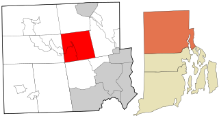
Coventry is a town in Kent County, Rhode Island, United States. The population was 35,688 at the 2020 census and is part of the Pawtuxet River Valley.

Greenville is a village and census-designated place (CDP) in the town of Smithfield in Providence County, Rhode Island, United States. The population was 8,658 at the 2010 census. The CDP is centered on the village of Greenville but also encompasses the nearby villages of West Greenville and Spragueville, as well as the Mountaindale Reservoir and beach.
Smithfield is a town that is located in Providence County, Rhode Island, United States. It includes the historic villages of Esmond, Georgiaville, Mountaindale, Hanton City, Stillwater and Greenville. The population was 22,118 at the 2020 census. Smithfield is the home of Bryant University, a private four year college.

Hope Valley is a village and census-designated place (CDP) in the town of Hopkinton in Washington County, Rhode Island, United States. The population of the CDP was 1,612 at the 2010 census. Hope Valley is the largest village in Hopkinton and the town's principal commercial center. While the village of Hope Valley is located in Hopkinton, its zip code, 02832, extends into the neighboring town of Richmond.

Nathanael Greene was a major general of the Continental Army in the American Revolutionary War. He emerged from the war with a reputation as General George Washington's most talented and dependable officer, and is known for his successful command in the southern theater of the war.
Forestdale is a village and historic district in North Smithfield, Providence County, Rhode Island, United States, one-half mile from Slatersville, Rhode Island. The historic district runs east and west along Main Street and north on Maple Avenue. School Street is the primary road through the village, and the one-room schoolhouse for which the street is named still stands. The Branch River runs through the valley adjacent to the School Street. The Village Haven Restaurant and local VFW chapter are also located in the village.
The Herreshoff Marine Museum, located in Bristol, Rhode Island, USA, is a maritime museum dedicated to the history of the Herreshoff Manufacturing Company, yachting, and the America's Cup. The Herreshoff Manufacturing Company (1878–1945) was most notable for producing sailing yachts, including eight America's Cup defenders, and steam-powered vessels.

Ironstone is an historic village,, in the township of Uxbridge, Massachusetts, United States. It derived its name from plentiful bog iron found here which helped Uxbridge to become a center for three iron forges in the town's earliest settlement. South Uxbridge has historic sites, picturesque weddings, hospitality, industrial and distribution centers, and the new Uxbridge High School. This community borders North Smithfield, and Burrillville, Rhode Island, and Millville, Massachusetts. South Uxbridge receives municipal services from Uxbridge, for fire, police, EMS, School district, public works, and other services. There is a South Uxbridge fire station of the Uxbridge fire department. Worcester's Judicial District includes Uxbridge District Court. Ironstone appears on the Blackstone U.S. Geological Survey Map. Worcester County is in the Eastern time zone and observes DST.
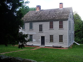
The General Nathanael Greene Homestead, also known as Spell Hall, is a historic house at 20 Taft Street in Coventry, Rhode Island. It was the home of American Revolutionary War general Nathanael Greene from 1770 to 1776, and was owned afterwards by his brother Jacob Greene and his wife Margaret. The house is owned and operated by the General Nathanael Greene Homestead Association, a non-profit organization, and was opened as a museum in 1924.

Hopkins Hollow Village is an historic district along Hopkins Hollow Road, Narrow Lane, and Perry Hill Road in Coventry, Rhode Island, United States, and West Greenwich, Rhode Island.
Washington is a village within the town of Coventry in Kent County, Rhode Island, and is part of the Pawtuxet River Valley.

Harris is a village near the town of Coventry, Rhode Island on the north branch of the Pawtuxet River near West Warwick.

Quidnick is a village within the town of Coventry, Rhode Island.
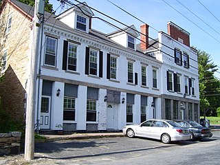
Coventry Centre is a historic village in Coventry, Rhode Island.
Fairbanks is a village in the town of Coventry, Rhode Island on Route 14, Plainfield Pike, right after the village of Rice City and near the Connecticut border.
Spring Lake is a village in the town of Coventry, Rhode Island.
Whaley's Hollow is a village in Coventry, Rhode Island.
Tiogue is a village in Coventry, Rhode Island near the village of Washington.
Blackrock is a village in Kent County, Rhode Island, United States, located in the town of Coventry between the villages of Anthony and Arkwright.

