Marine biology is the scientific study of marine life, organisms in the sea. Given that in biology many phyla, families and genera have some species that live in the sea and others that live on land, marine biology classifies species based on the environment rather than on taxonomy.
FishBase is a global species database of fish species. It is the largest and most extensively accessed online database on adult finfish on the web. Over time it has "evolved into a dynamic and versatile ecological tool" that is widely cited in scholarly publications.
Species richness, or biodiversity, increases from the poles to the tropics for a wide variety of terrestrial and marine organisms, often referred to as the latitudinal diversity gradient (LDG). The LDG is one of the most widely recognized patterns in ecology. The LDG has been observed to varying degrees in Earth's past. A parallel trend has been found with elevation, though this is less well-studied

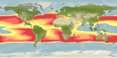
Species distribution is the manner in which a biological taxon is spatially arranged. The geographic limits of a particular taxon's distribution is its range, often represented as shaded areas on a map. Patterns of distribution change depending on the scale at which they are viewed, from the arrangement of individuals within a small family unit, to patterns within a population, or the distribution of the entire species as a whole (range). Species distribution is not to be confused with dispersal, which is the movement of individuals away from their region of origin or from a population center of high density.
C-squares is a system of spatially unique, location-based identifiers (geocodes) for areas on the surface of the earth, represented as cells from a Discrete Global Grid at a hierarchical set of resolution steps. The identifiers incorporate literal values of latitude and longitude in an interleaved notation, together with additional digits that support intermediate grid resolutions of 5, 0.5, 0.05 degrees, etc. The system was initially designed to represent data "footprints" or spatial extents in a more flexible manner than a standard minimum bounding rectangle, and to support "lightweight", text-based spatial querying; it can also provide a set of identifiers for grid cells used for assembly, storage and analysis of spatially organised data. Dataset extents expressed in c-squares notation can be visualised using a web-based utility, the c-squares mapper, an online instance of which is currently provided by CSIRO Oceans and Atmosphere in Australia. C-squares codes and associated published software are free to use and the software is released under version 2 of the GNU General Public License (GPL), a licence of the Free Software Foundation.

Integrated multi-trophic aquaculture (IMTA) provides the byproducts, including waste, from one aquatic species as inputs for another. Farmers combine fed aquaculture with inorganic extractive and organic extractive aquaculture to create balanced systems for environment remediation (biomitigation), economic stability and social acceptability.
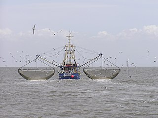
A fishery is an area with an associated fish or aquatic population which is harvested for its commercial value. Fisheries can be marine (saltwater) or freshwater. They can also be wild or farmed.
Earthwatch Institute is an international environmental charity founded as Educational Expeditions International in 1971 near Boston (USA) by Robert A. Citron and Clarence Truesdale, then superintendent of Vermont public schools. It is one of the largest global underwriters of scientific field research in archaeology, paleontology, marine life, biodiversity, ecosystems and wildlife. For over forty years, Earthwatch has delivered a unique citizen science model to raise funds and recruit individuals, students, teachers and corporate fellows to participate in critical field research to understand nature's response to accelerating global change. Earthwatch's work supports hundreds of Ph.D. researchers across dozens of countries, conducting over 100,000 hours of research annually.
Ecological forecasting uses knowledge of physics, ecology and physiology to predict how ecological populations, communities, or ecosystems will change in the future in response to environmental factors such as climate change. The ultimate goal of the approach is to provide people such as resource managers and designers of marine reserves with information that they can then use to respond, in advance, to future changes, a form of adaptation to global warming.
The Future of Marine Animal Populations (FMAP) project was one of the core projects of the international Census of Marine Life (2000–2010). FMAP's mission was to describe and synthesize globally changing patterns of species abundance, distribution, and diversity, and to model the effects of fishing, climate change and other key variables on those patterns. This work was done across ocean realms and with an emphasis on understanding past changes and predicting future scenarios.
Mechanistic models for niche apportionment are biological models used to explain relative species abundance distributions. These niche apportionment models describe how species break up resource pool in multi-dimensional space, determining the distribution of abundances of individuals among species. The relative abundances of species are usually expressed as a Whittaker plot, or rank abundance plot, where species are ranked by number of individuals on the x-axis, plotted against the log relative abundance of each species on the y-axis. The relative abundance can be measured as the relative number of individuals within species or the relative biomass of individuals within species.
Relative species abundance is a component of biodiversity and refers to how common or rare a species is relative to other species in a defined location or community. Relative abundance is the percent composition of an organism of a particular kind relative to the total number of organisms in the area. Relative species abundances tend to conform to specific patterns that are among the best-known and most-studied patterns in macroecology. Different populations in a community exist in relative proportions; this idea is known as relative abundance.

Species distribution modelling (SDM), also known as environmental(or ecological) niche modelling (ENM), habitat modelling, predictive habitat distribution modelling, and range mapping uses computer algorithms to predict the distribution of a species across geographic space and time using environmental data. The environmental data are most often climate data, but can include other variables such as soil type, water depth, and land cover. SDMs are used in several research areas in conservation biology, ecology and evolution. These models can be used to understand how environmental conditions influence the occurrence or abundance of a species, and for predictive purposes. Predictions from an SDM may be of a species’ future distribution under climate change, a species’ past distribution in order to assess evolutionary relationships, or the potential future distribution of an invasive species. Predictions of current and/or future habitat suitability can be useful for management applications.

The wildlife of the Philippines includes a significant number of endemic plant and animal species. The country's surrounding waters reportedly have the highest level of marine biodiversity in the world. The Philippines is considered as one of the seventeen megadiverse countries as well as global biodiversity hotspot. In the 2000 Red List of the International Union for the Conservation of Nature and Natural Resources (IUCN), 418 of the country's 52,177 species were listed as threatened.
Rainer Froese, born 25 August 1950 in Wismar, Germany, is a senior scientist at the Helmholtz Center for Ocean Research (GEOMAR) in Kiel, formerly the Leibniz Institute of Marine Sciences (IFM-GEOMAR), and a Pew Fellow in Marine Conservation. He obtained an MSc in Biology in 1985 at the University of Kiel and a PhD in Biology in 1990 from the University of Hamburg. Early in his career, he worked at the Institute of Marine Sciences on computer-aided identification systems and the life strategies of fish larvae. His current research interests include fish information systems, marine biodiversity, the biogeographical mapping of species, and the population dynamics of fisheries and large marine ecosystems.
SeaLifeBase is a global online database of information about marine life. It aims to provide key information on the taxonomy, distribution and ecology of all marine species in the world apart from finfish. SeaLifeBase is in partnership with the WorldFish Center in Malaysia and the UBC Fisheries Centre at the University of British Columbia. Daniel Pauly is the principal investigator and it is coordinated by Maria Lourdes D. Palomares. As of October 2016, it included descriptions of 74,000 species, 47,700 common names, 12,400 pictures, and references to 31,700 works in the scientific literature. SeaLifeBase complements FishBase, which provides parallel information for finfish.

Li Sizhong was an ichthyologist with the Institute of Zoology (中国科学院动物研究所) at the Chinese Academy of Sciences. Throughout his research career, he made numerous discoveries of new fish species, and published many books and research papers describing the fauna and geographical distribution of fishes in China and beyond. He translated and helped publication of the Chinese editions of Fishes of the World and Fish Migration. Li was the major author of two published volumes in the Fauna Sinica monograph series, systematically reviewing and describing orders of bony fishes that include flat fish, cod, silverside, pearlfish, killifish, flying fish, etc. in or near China. He had written over 40 popular science articles about fish on Chinese newspapers and magazines, and been responsible for compiling and editing fish-related entries in several standard reference books.
A gradsect or gradient-directed transect is a low-input, high-return sampling method where the aim is to maximise information about the distribution of biota in any area of study. Most living things are rarely distributed at random, their placement being largely determined by a hierarchy of environmental factors. For this reason, standard statistical designs based on purely random sampling or systematic systems tend to be less efficient in recovering information about the distribution of taxa than sample designs that are purposively directed instead along deterministic environmental gradients.
SeaKeys is a large collaborative marine biodiversity project funded through the Foundational Biodiversity Information Program in South Africa. The purpose of the project is to collect and distribute genetic, species and ecosystem information relating to marine biodiversity in southern Africa, which may be used to support informed decision-making about the marine environment.

The Ocean Biodiversity Information System (OBIS), formerly Ocean Biogeographic Information System, is a web-based access point to information about the distribution and abundance of living species in the ocean. It was developed as the information management component of the ten year Census of Marine Life (CoML) (2001-2010), but is not limited to CoML-derived data, and aims to provide an integrated view of all marine biodiversity data that may be made available to it on an open access basis by respective data custodians. According to its web site as at July 2018, OBIS "is a global open-access data and information clearing-house on marine biodiversity for science, conservation and sustainable development." 8 specific objectives are listed in the OBIS site, of which the leading item is to "Provide [the] world's largest scientific knowledge base on the diversity, distribution and abundance of all marine organisms in an integrated and standardized format".