Arthur Kill Bridge

Last updated
Arthur Kill Bridge
Coordinates 40°38′15″N74°11′44″W / 40.637518°N 74.195486°W / 40.637518; -74.195486 Coordinates: 40°38′15″N74°11′44″W / 40.637518°N 74.195486°W / 40.637518; -74.195486
Carries Baltimore & Ohio Railroad (B&O)
Staten Island Railroad (SIR)
Crosses Arthur Kill
Locale Elizabeth, Union County, New Jersey & Staten Island, New York City
OwnerB&O
Characteristics
Design Through truss swing
Total length800 feet (240 m)
Longest span500 feet (150 m)
No. of spans3
Clearance below 32 feet (9.8 m)
History
DesignerCharles Ackenheit
Constructed byKeystone Bridge Company
Construction cost$500,000
OpenedJanuary 1, 1890
Closed1959
Location
Arthur Kill Bridge
References
[1]

The Arthur Kill Bridge was a railroad bridge connecting Staten Island, New York to New Jersey's Chemical Coast by crossing the Arthur Kill. It existed from 1888 [2] [3] [4] until 1959, when it was replaced by the current Arthur Kill Vertical Lift Bridge, built nearby. It was the only land connection to Staten Island until 1928.

Contents

Proposal for a bridge

Although a temporary pontoon bridge to Elizabeth, New Jersey was built by the British during the Revolution, Staten Island was usually accessible only by ferry to New Jersey or by private boat. It was not until 1810 that regular ferry service was established to Manhattan.

As early as 1850, campaigns for a bridge to Bayonne, New Jersey were begun by some summer residents of the island, although opposed by many permanent residents. In 1870 the New York State Legislature passed a bill authorizing a swing-span bridge from New Brighton, Staten Island to Ellis Island via Robbins Reef. A charter was granted to the Staten Island Bridge Company, but the project was eventually abandoned due to fiscal constraints. [5]

The proposal to build a railroad bridge over the Arthur Kill existed from at least 1886, when Erastus Wiman, a developer who was founder and president of the Staten Island Railway, persuaded the Baltimore and Ohio Railroad to finance a bridge over the Arthur Kill in exchange for use of Wiman's railroad facilities on the island.

In the summer of 1886 the Board of Army Engineers for Fortifications held a hearing at the Army Building in Manhattan to determine the preferred location for the interstate bridge that had recently been authorized by Congress. Speaking in favor of the bridge were representatives of the Baltimore and Ohio Railroad and Erastus Wiman. Opposed to the proposed location were Senator Chase, representing the Pennsylvania Railroad, and I. L. Fisher of the Bee Towing Company. The opponents preferred building a 70-foot high (21.34 m) bridge near Buckwheat Island, about one mile (1.6 km) south of the proposed location. The Board reported to the Secretary of War. [6]

Description and history

Rendering of the proposed bridge, 1885 Baltimore & Ohio Viaduct Under Construction Over the Arthur Kill Connecting Staten Island and New Jersey.png
Rendering of the proposed bridge, 1885

The approved bridge was designed by Charles Ackenheit (or Ackenheil [7] ), the chief engineer for the Baltimore and Ohio Railroad. The cost was approximately $500,000. Construction occurred from 1887 to 1889 and the bridge opened with ceremony on January 1, 1890. [3] It was also called the "Achter Kill Bridge" after the alternate spelling and pronunciation of Arthur Kill. [3] At the time of its completion, it was the longest of its type in the world. [8]

It was a swing-span railroad bridge with a center pier, connecting the Howland Hook area of Staten Island to Elizabeth, New Jersey, where tracks could connect with a Baltimore and Ohio branch line. The center span was 500 feet (152 m) long, with two fixed 150 feet (45.7 m) side spans, for a total length of 800 feet (244 m). Compared to the 70-foot high (21.34 m) bridge proposed by the Pennsylvania Railroad, the bridge was built only 32 feet (9.75 m) above Arthur Kill at low water. This would necessitate frequent openings, especially in later years after the kill was dredged and numerous ocean-going ships needed to pass through the strait. In 1952, for example, the bridge was required to be open to allow 13,346 ships to pass. The span was moved by two steam-powered engines. In foggy weather a steam whistle would sound twice to indicate the bridge was closed, or four times so boats would know it was open.

The bridge was used for freight trains. There was never any regular passenger service over the bridge, although during both World War I and World War II, numerous troop trains would deliver soldiers bound for Europe to ships waiting at the Staten Island port of embarkation piers. [5] Also, in October 1957, a train carrying Queen Elizabeth II and Prince Philip from Washington to the Staten Island Ferry during a state visit crossed the bridge. [9]

In late 1952, the swing span was turned by heavy winds and could not be closed for some time. At other times at least one ship crashed into the bridge, and there was at least one case where boats collided while navigating under the bridge. By the 1950s the bridge was considered outdated and a hazard to navigation. A replacement bridge, the Arthur Kill Vertical Lift Bridge, was built 150 feet (45.7 m) away from the Arthur Kill Bridge. The new bridge, financed primarily by the federal government, had a center span 58 feet (17.7 m) longer than the old bridge, with no center pier, and its clearance was more than 100 feet (30.5 m) higher than the old span. The new bridge was inaugurated in August 1959, and the Arthur Kill Bridge was then removed; its granite piers had to be blasted away. [5]

Related Research Articles

<span class="mw-page-title-main">Goethals Bridge</span> Bridge between New Jersey and New York, United States

The Goethals Bridge is the name of a pair of cable-stayed bridge spans connecting Elizabeth, New Jersey, to Staten Island, New York, in the United States. The spans cross a strait known as Arthur Kill, and replaced a cantilever bridge span built in 1928. The bridge is operated by the Port Authority of New York and New Jersey.

<span class="mw-page-title-main">Staten Island Ferry</span> Passenger ferry service in New York City

The Staten Island Ferry is a passenger ferry route operated by the New York City Department of Transportation. The ferry's single route runs 5.2 miles (8.4 km) through New York Harbor between the New York City boroughs of Manhattan and Staten Island, with ferry boats making the trip in about 25 minutes. The ferry operates 24 hours a day, 7 days a week, with boats leaving every 15 to 20 minutes during peak hours and every 30 minutes at other times. It is the only direct mass-transit connection between the two boroughs. Historically, the Staten Island Ferry has charged a relatively low fare compared to other modes of transit in the area; and since 1997, the route has been fare-free. The Staten Island Ferry is one of several ferry systems in the New York City area and is operated separately from systems such as NYC Ferry and NY Waterway.

<span class="mw-page-title-main">Staten Island Railway</span> Rapid transit line in New York City

The Staten Island Railway (SIR) is a rapid transit line in the New York City borough of Staten Island. It is owned by the Staten Island Rapid Transit Operating Authority (SIRTOA), a subsidiary of the Metropolitan Transportation Authority, and operated by the New York City Transit Authority Department of Subways. SIR operates 24 hours a day, seven days a week, providing local service between St. George and Tottenville, along the east side of the island. There is currently only one line on the island, and there is no direct rail link between the SIR and the New York City Subway system, but SIR riders do receive a free transfer to New York City Transit bus and subway lines, and the line is included on official New York City Subway maps. Commuters on the railway typically use the Staten Island Ferry to reach Manhattan. The line is accessible from within the Ferry Terminal, and most of its trains are timed to connect with the ferry. In 2021, the system had a ridership of 2,783,800, or about 12,700 per weekday as of the third quarter of 2022.

<span class="mw-page-title-main">Arthur Kill</span> Navigational channel of the Port of New York and New Jersey

The Arthur Kill is a tidal strait between Staten Island, New York and Union and Middlesex counties, New Jersey. It is a major navigational channel of the Port of New York and New Jersey.

<span class="mw-page-title-main">Bayonne Bridge</span> Bridge between New Jersey and New York

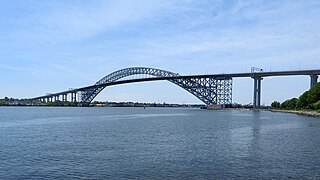
Bayonne Bridge is an arch bridge spanning the Kill Van Kull and connecting Bayonne, New Jersey with Staten Island in New York City. It carries New York State Route 440 (NY 440) and New Jersey Route 440. It is the sixth-longest steel arch bridge in the world, and it was the longest in the world at the time of its completion. The bridge is also one of four connecting New Jersey with Staten Island; the other two roadway bridges are the Goethals Bridge in Elizabeth and Outerbridge Crossing in Perth Amboy, and the rail-only span is the Arthur Kill Vertical Lift Bridge, all of which cross the Arthur Kill.

<span class="mw-page-title-main">Car float</span> Unpowered barge with railroad tracks mounted on its deck

A railroad car float or rail barge is a specialised form of lighter with railway tracks mounted on its deck used to move rolling stock across water obstacles, or to locations they could not otherwise go. An unpowered barge, it is towed by a tugboat or pushed by a towboat.

<span class="mw-page-title-main">Erastus Wiman</span>

Erastus Wiman was a Canadian journalist and businessman who later moved to the United States. He is best known as a developer in the New York City borough of Staten Island.

<span class="mw-page-title-main">CRRNJ Newark Bay Bridge</span> Railroad bridge connecting Elizabethport and Bayonne

The Newark Bay Bridge of the Central Railroad of New Jersey (CNJ) was a railroad bridge in New Jersey that connected Elizabethport and Bayonne at the southern end of Newark Bay. Its third and final incarnation was a four-track vertical-lift design that opened in 1926, replacing a bascule bridge from 1904 which superseded the original swing bridge from 1887. The bridge served the main line of the CNJ, carrying daily interstate trains as well as commuter trains.

<span class="mw-page-title-main">Arthur Kill Vertical Lift Bridge</span> Bridge between New Jersey and New York

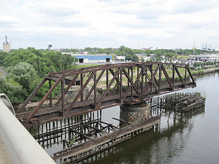
The Arthur Kill Vertical Lift Railroad Bridge is a rail vertical-lift bridge connecting Elizabethport, New Jersey and the Howland Hook Marine Terminal on Staten Island, New York, United States. The bridge was built by the Baltimore and Ohio Railroad in 1959 to replace the Arthur Kill Bridge, a swing bridge opened in 1890. It contains a single track that is used mainly to carry garbage out of New York City, as well as to transport freight to destinations in western Staten Island. The bridge parallels the Goethals Bridge, which carries Interstate 278. It has the longest lift span of any vertical-lift bridge in the world, with two 215-foot (66 m) towers and a 558-foot (170 m) truss span that allows a 500-foot (152 m) channel. It clears mean high water by 31 feet (9.45 m) when closed and 135 feet (41 m) when lifted.

<span class="mw-page-title-main">CSX Susquehanna River Bridge</span> Bridge in Maryland and Perryville, Maryland

The CSX Susquehanna River Bridge is a railroad bridge that carries CSX's Philadelphia Subdivision across the Susquehanna River between Havre de Grace and Perryville, Maryland, via Garrett Island. It was built in 1907-10 by the Baltimore and Ohio Railroad (B&O) on the same alignment as an 1886 B&O bridge. Like its predecessor, it was the longest continuous bridge on the B&O system.

<span class="mw-page-title-main">Port of New York and New Jersey</span> Port in New York and New Jersey, United States

The Port of New York and New Jersey is the port district of the New York-Newark metropolitan area, encompassing the region within approximately a 25-mile (40 km) radius of the Statue of Liberty National Monument.

<span class="mw-page-title-main">St. George Terminal</span> Transit center in Staten Island, New York

St. George Terminal is a ferry, railway, bus, and park and ride transit center in the St. George neighborhood of Staten Island, New York City. It is located at the intersection of Richmond Terrace and Bay Street, near Staten Island Borough Hall, Richmond County Bank Ballpark and Richmond County Supreme Court. St. George is one of the few remaining rail-boat connections in the United States.

<span class="mw-page-title-main">Arlington Yard</span> Freight rail yard on Staten Island, New York City

Arlington Yard is a freight yard located on the North Shore Branch right of way of the Staten Island Railway in Staten Island, New York, United States. It lies west of the former Arlington station, east of Western Avenue, and north of the Staten Island Expressway in the Port Ivory neighborhood. The yard leads into the Travis Branch of the railway, the Howland Hook Container Terminal, and the Arthur Kill Lift Bridge to Elizabeth, New Jersey and the Chemical Coast and is part of the ExpressRail network.

<span class="mw-page-title-main">Staten Island Tunnel</span> Abandoned and incomplete subway tunnel in New York City

The Staten Island Tunnel is an abandoned, incomplete railway/subway tunnel in New York City. It was intended to connect railways on Staten Island to the BMT Fourth Avenue Line of the New York City Subway, in Brooklyn, via a new crossing under the Narrows. Planned to extend 10,400 feet (3,200 m), the tunnel would have been among the world's longest at the time of its planning, in the late 19th and early 20th centuries.

<span class="mw-page-title-main">Perth Amboy Ferry Slip</span> United States historic place

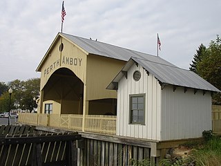
The Perth Amboy Ferry Slip, located on the Arthur Kill in Perth Amboy, Middlesex County, New Jersey, United States, was once a vital ferry slip for boats in New York Harbor. It was added to the New Jersey Register of Historic Places and National Register of Historic Places in 1978. The ferry slip was restored in 1998 to its 1904 appearance. A replica of the ticket office has been constructed and is used as a small museum.

<span class="mw-page-title-main">Philadelphia, Wilmington and Baltimore Railroad Bridge No. 1</span> Railroad bridge in Philadelphia, Pennsylvania

Philadelphia, Wilmington and Baltimore Railroad Bridge No. 1 was a swing steel through truss that spanned the Schuylkill River between Philadelphia, Pennsylvania's Kingsessing and Grays Ferry neighborhoods.

<span class="mw-page-title-main">North Shore Branch</span> Railroad branch in Staten Island, New York

The North Shore Branch is an abandoned branch of the Staten Island Railway in New York City, which operated along Staten Island's North Shore from Saint George to Port Ivory. The line continues into New Jersey via the Arthur Kill Vertical Lift Bridge to Aldene Junction in Cranford.

<span class="mw-page-title-main">History of the Staten Island Railway</span> Aspect of history surrounding the Staten Island Railway

The Staten Island Railway (SIR) is the only rapid transit line in the New York City borough of Staten Island and is operated by the Staten Island Rapid Transit Operating Authority, a unit of the Metropolitan Transportation Authority. The railway was historically considered a standard railroad line, but today only the western portion of the North Shore Branch, which is disconnected from the rest of the SIR, is used by freight and is connected to the national railway system.

The Baltimore and New York Railway was a railroad line built by the Baltimore and Ohio Railroad (B&O) from Cranford, New Jersey, to the western side of the Arthur Kill Bridge in New Jersey, connecting with the North Shore Branch of Staten Island Rapid Transit. The line was built to provide the B&O access to a terminal in New York City, in Staten Island. Today, the line is used by CSX Transportation for freight trains.

References

  1. "Arthur Kill Bridge". Bridgehunter.com. Retrieved 5 February 2018.
  2. "The Largest Drawbridge" (PDF). The New York Times. June 14, 1888. Retrieved 13 February 2018.
  3. 1 2 3 Staten Island Institute of Arts and Sciences (1916). Proceedings - Staten Island Institute of Arts and Sciences, Volumes 5-6. New Brighton, New York: Staten Island Institute of Arts and Sciences. Retrieved 6 August 2015.
  4. Matteo, Thomas (April 22, 2015). "B&O Railroad had strong presence on Staten Island for 100 years". Staten Island Advance . Staten Island, New York . Retrieved 1 August 2015.
  5. 1 2 3 Sharon Reier. The Bridges of New York, Dover Publications, Inc., pp. 109-110. ISBN   0-486-41230-X
  6. "The Arthur Kill Bridge", The New York Times , August 28, 1886 (Note: The article refers to "Senator Chase", possibly intending Jonathan Chace of Rhode Island.)
  7. The surname is spelled Ackenheil in the 1886 New York Times article.
  8. Pitanza, Mark (2015). Staten Island Rapid Transit. Charleston, South Carolina: Arcadia Publishing. p. 8. ISBN   978-1467123389.
  9. Forgotten New York: Staten Island Railway