Australian Research Centre for Aerospace Automation

Last updated

The Australian Research Centre for Aerospace Automation (ARCAA) was a research centre of the Queensland University of Technology. ARCAA conducted research into all aspects of aviation automation, with a particular research focus on autonomous technologies which support the more efficient and safer utilisation of airspace, and the development of autonomous aircraft and on-board sensor systems for a wide range of commercial applications. [1]

Contents

History

ARCAA was the brainchild of the late Professor Rod Walker from QUT's then School of Engineering Systems; QUT's Professor Jonathan Roberts (when he was at CSIRO); and Professor Peter Corke from QUT's School of Electrical Engineering and Computer Systems (when he was at CSIRO). [2]

In 2008, QUT and CSIRO entered into a five-year research joint venture agreement for the creation of the Australian Research Centre for Aerospace Automation. The establishment of the physical Centre was co-funded through the Queensland Government’s Smart State Research Facilities Fund. [3]

In 2013, ARCAA entered into a new phase of operations, as the joint venture between QUT and CSIRO ended. The strong research collaboration between QUT and CSIRO has continued however, especially on the flagship research project, Project ResQu. [4]

ARCAA research interests included Unmanned aerial system topics, airspace automation and related fields. It was the co-organiser of the annual international robotics event UAV Outback Challenge since 2007.

Recent projects

ARC Discovery Early Career Researcher Award (DECRA) – Developing Novel Concepts for Improved Safety in Aircraft Emergency Situations The aim of this project was to create an emergency system based on novel detection, control and planning algorithms that can be used in specific cases to improve pilot’s visual situation awareness in emergency forced landing scenarios. This work was evaluated in the context of a landing site detection and guidance problems, and proven on ARCAA's fleet of manned and unmanned aircraft.

UAS for Myrtle Rust Inspection This study examined the impacts of myrtle rust on Melaleuca quinquenervia host species across an environmental gradient. Direct impacts on the M. quinquenervia hosts were assessed using above canopy photographic techniques acquired using UAS equipped with EO cameras, as they offered a sufficient method to capture fine scale data of the forest canopy, including incidence and severity scores, as were able to fly low and slow. UAS will assist in the examination of myrtle rust impacts by allowing the evaluation of individual structure (clustering of spores on a leaf) and changes in their spatiotemporal dynamics.

UAS for Koala Population Assessment This was a comparative study of UAS equipped with thermal cameras for population count in a ground-truthed area. The purpose of the project was to assess the efficacy of UAS for rapid assessment of koala population densities.

Drone swarms for persistent operations with human operator control This project investigated control technologies for swarms of drones (UAVs) conducting tasks such as surveillance, search and rescue, and fire monitoring.

Application-based regional airspace modelling and flight plan design This project aimed to address how regional airspace can routinely accommodate UAVs operating in regional areas.

Interactive systems The Interactive Systems Group (ISG) was a research group embedded within ARCAA. The ISG conducted research into all aspects of complex human-machine systems and in particular those systems involving the command and control of heterogeneous autonomous agents. The aim of the group was to develop the concepts necessary for the safe and efficient operation of complex interacting human-machine systems in a broad range of applications.

Past projects

Project ResQu This two-year project, co-funded through the Queensland Government Smart Futures Fund, Boeing Research & Technology Australia, Insitu Pacific Ltd., CSIRO and QUT undertook the safety studies and developed the automated safety technologies necessary to enable the timely approval of UA for disaster recovery, as well as routinely delivering benefits through surveys for biosecurity and resource management.

CRC PB5055 – UAVs for Plant Biosecurity The primary objective of the research was the qualitative evaluation of the use of UAS for biosecurity applications. The goal was to determine the fundamental factors pertaining to the operation of various UAS that will significantly influence how and where UAS can be effective throughout the plant biosecurity continuum. To this end UAS regulation and performance attributes were considered in conjunction to the sensor payloads they may carry. Collectively, the outputs from the study can be used to inform key stakeholders regarding decisions to use UAS in the near and short term as part of a biosecurity system.

Scoping Study for UAS Airspace Integration and Enhanced Conflict Management This project identified existing unmanned aircraft (UA) airspace integration work being conducted elsewhere in the world, and pin-pointed operational concepts specific to the operation of UA in Australia’s distinctive environment. Whilst UA are yet to enter civil airspace on a routine basis, they are becoming more prevalent as they move beyond the military sphere into the realm of government, private sector and commercial operators. This use is anticipated to grow in the future, hence the requirement to ensure that Australia’s air traffic management systems are ready to cater for them.

Green Falcon Solar Powered UAV: Multidisciplinary Design and Uncertainty Based Path Planning for Persistent Environmental Gas Sensing Monitoring This project focused upon the development of artificial intelligence, autonomy and a gas sensing capability for electric and solar powered UAVs. Unlike other solar UAVs, the Green Falcon is designed to be cost-effective, light weight and easily hand-launched with minimum maintenance requirements. The design supports improved endurance capabilities compared with other UAVs in the same class, which will allow the Green Falcon to provide rapid deployment and will be particularly useful in plant biosecurity, gas sensing, search and rescue or fire monitoring missions.

Vision-Based Collision Avoidance The ARCAA automated vision-based aircraft collision warning technologies project was a two-year Australian Research Council Linkage funded project between Boeing Research & Technology and ARCAA. The objective of the project is to investigate how computer vision technology can be used to meet and exceed the performance of human pilots in detecting potential aircraft collisions, thereby improving the safety of the world’s aviation fleets.

enhanced Flight Assist System (eFAS) for Automated Aerial Survey of Powerline Networks The objective of this project was the development of flight-path planning and aircraft guidance and control technology to suit the unique features of the consistent-sensing low-altitude trajectory-constrained aerial inspection problem. This problem is defined by the airborne collection of spatial information that is related to approximately linear power-line "feeder"-type infrastructure. Working with the CRC for Spatial Information and Ergon Energy, previous research had already demonstrated the essential importance of basic automation technologies in such large-scale inspection tasks. The specific objective of this project was the development of additional automation mechanisms that improve inspection efficiency, operational flexibility, and operational reliability so that high quality spatial information can be delivered in a timely and cost effective manner. The potential benefits of advanced 3D planning and flight control for the powerline network inspection activity include reduced pilot workload in both horizontal and vertical control of the aircraft, by maintaining safe horizontal and vertical separation from terrain/obstacles, and positioning the aircraft at the correct altitude, speed and orientation for effective data capture.

Technical and Market analysis of Gimbal Sensor Systems This project was a due diligence analysis conducted by ARCAA and CRCSI consultants as part of ROAMES research for Ergon Energy. It focused on the application of gimbal sensor systems mounted on an aeroplane for still image or video data capturing of power poles or other assets.

Flight Assist System The Flight Assist System (FAS) is a demonstrator project assisting Ergon Energy in development of the research outcome of a three-year CRC-SI project which focused on business improvement applications for Ergon Energy. The outcome of the CRC-SI project was a proposal for an advanced airborne vegetation management system that would save AUD$14 million per year. To commercialise the research outcomes, Ergon decided to launch the Remote Observation, Automated Modelling & Economic Simulation (ROAMES) project of which FAS is an essential component. ROAMES has since been divested to Fugro Spatial Solutions.

Smart Skies Project The Smart Skies Project is a leading edge research program exploring the research and development of future technologies that support the efficient utilisation of airspace by both manned and unmanned aircraft. It focused upon the exploration and development of three key enabling aviation technologies – an automated separation management system capable of providing separation assurance in complex airspace environments; sense-and-act systems for manned and unmanned aircraft capable of collision avoidance of dynamic and static obstacles; and a mobile aircraft tracking system utilising a cost-effective radar and dependent surveillance systems.

Airborne Powerline Inspection Technology Improvements The three year CRC-SI project 6.07 for Spatial information Business improvement applications at Ergon Energy focussed on precision guidance of aircraft over powerlines, asset and vegetation detection using LiDAR imagery, and detection and classification of tree species. The project was successfully completed in 2010 and provided the fundamental basis for the FAS project.

Whole of Network Planning The Whole of Network planning project involved research and development of new software to automatically process up to one million waypoints to create flight plans for inspecting Ergon Energy’s entire powerline network which is approximately 150,000 km and covers 97% of the state of QLD, Australia.

Flying Spore Trap This project and associated research aimed to determine the potential of using an unmanned aerial vehicle, fitted with a spore trap, to detect and monitor spores of plant pathogens for a biosecure Australia. The objective was to develop a sampling system that would have the ability to spatially monitor fungal spores, and protocols to interpret their spatial distribution. This tool will greatly enhance the ability to detect new incursions of fungal pathogens and to enable more accurate delimiting of distribution. The technology will allow for earlier detection of harmful plant pest or disease incursions in difficult areas and provide efficient and effective airborne surveillance.

Research collaborators

ARCAA conducted research projects and consultancies with a wide variety of government, industry and academic institutions - projects have involved:

Related Research Articles

<span class="mw-page-title-main">Unmanned aerial vehicle</span> Aircraft without any human pilot on board

An uncrewed aerial vehicle (UAV), commonly known as a drone, is an aircraft without any human pilot, crew, or passengers on board. UAVs were originally developed through the twentieth century for military missions too "dull, dirty or dangerous" for humans, and by the twenty-first, they had become essential assets to most militaries. As control technologies improved and costs fell, their use expanded to many non-military applications. These include aerial photography, area coverage, precision agriculture, forest fire monitoring, river monitoring, environmental monitoring, policing and surveillance, infrastructure inspections, smuggling, product deliveries, entertainment, and drone racing.

<span class="mw-page-title-main">Aerial photography</span> Taking images of the ground from the air

Aerial photography is the taking of photographs from an aircraft or other airborne platforms. When taking motion pictures, it is also known as aerial videography.

<span class="mw-page-title-main">AAI Corporation</span>

AAI Corporation is an aerospace and defense development and manufacturing firm, located in Hunt Valley, Maryland, US. Formerly a wholly owned subsidiary of United Industrial Corporation, AAI was acquired by Textron in 2007. It currently operates as a unit of Textron Systems and employs more than 2,000.

<span class="mw-page-title-main">AeroVironment</span> American unmanned aerial vehicle manufacturer

AeroVironment, Inc. is an American defense contractor headquartered in Arlington, Virginia, that designs and manufactures unmanned aerial vehicles (UAVs). Paul B. MacCready Jr., a designer of human-powered aircraft, founded the company in 1971. The company is best known for its lightweight human-powered and solar-powered vehicles. The company is the US military's top supplier of small drones —notably the Raven, Switchblade, Wasp and Puma models.

<span class="mw-page-title-main">Boeing Insitu ScanEagle</span> Reconnaissance unmanned aerial vehicle

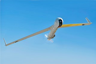
The Boeing Insitu ScanEagle is a small, long-endurance, low-altitude unmanned surveillance and reconnaissance aerial vehicle built by Insitu, a subsidiary of Boeing, and is used for reconnaissance. The ScanEagle was designed by Insitu based on the Insitu SeaScan, a commercial UAV that was intended for fish-spotting. The ScanEagle continues to receive improvements through upgrades and changes.

Access 5 was a national project run by NASA in collaboration with industry, the Federal Aviation Administration (FAA), and the United States Department of Defense (DoD), in order to introduce high altitude, long endurance (HALE) remotely operated aircraft (ROA) for routine flights in the National Airspace System (NAS). It was the first project in the United States to formally attempt to integrated unmanned aircraft into the national airspace system (NAS). The primary objective was to open up airspace for commercial unmanned aviation. Access 5 commenced in May 2004 and was slated to run for five years. The project received initial funding in the amount of $101M from NASA and guarantees of support from the ROA industry. It was managed out of Dryden Flight Research Center. The program was managed by Jeff Bauer out of NASA Dryden and R. Scott Dann, a General Atomics program manager who filled the role of industry director. R. Scott Dann was also the founder and first president of the UAV National Industry Team (UNITE). A good portion of the leadership on the Access 5 program were involved in the NASA ERAST program, another pioneering program in UAS development.

The Next Generation Air Transportation System (NextGen) is an ongoing United States Federal Aviation Administration (FAA) project to modernize the National Airspace System (NAS). The FAA began work on NextGen improvements in 2007 and plans to finish the final implementation segment by 2030. The goals of the modernization include using new technologies and procedures to increase the safety, efficiency, capacity, access, flexibility, predictability, and resilience of the NAS while reducing the environmental impact of aviation.

<span class="mw-page-title-main">UAV Outback Challenge</span> Annual robotics challenge

The UAV Challenge - Outback Rescue, also known as the UAV Outback Challenge or UAV Challenge, is an annual competition for the development of unmanned aerial vehicles. The competition was first held in 2007 and features an open challenge for adults, and a high-school challenge. The event is aimed at promoting the civilian use of unmanned aerial vehicles and the development of low-cost systems that could be used for search and rescue missions. The event is one of the largest robotics challenges in the world and one of the highest stakes UAV challenges, with the 2018 Medical Express version of the event offering $75,000 to the winner.

Autonomous Systems Technology Related Airborne Evaluation & Assessment (ASTRAEA) is a project to develop unmanned aerial vehicles (UAV) to fly in civil airspace. Both UK government agencies and companies such as AOS Group, BAE Systems, Qinetiq, Rolls-Royce plc, Cassidian, Cobham plc, EADS and Thales UK are involved. The project began in 2006.

The Northrop Grumman RQ-180 is an American stealth unmanned aerial vehicle (UAV) surveillance aircraft intended for contested airspace. As of 2019, there had been no images or statements released, but growing evidence points to the existence of the RQ-180 and its use in regular front-line service. The use of the nickname "White Bat" in a 2021 video released by the US Air Force Profession of Arms Center of Excellence (PACE) suggests that the military may be preparing to release information on the RQ-180.

Unmanned aircraft system simulation focuses on training pilots to control an unmanned aircraft or its payload from a control station. Flight simulation involves a device that artificially re-creates aircraft flight and the environment in which it flies for pilot training, design, or other purposes. It includes replicating the equations that govern how aircraft fly, how they react to applications of flight controls, the effects of other aircraft systems, and how the aircraft reacts to external factors such as air density, turbulence, wind shear, cloud, precipitation, etc.

The US Federal Aviation Administration has adopted the name small unmanned aircraft system (sUAS) to describe aircraft systems without a flight crew on board weighing less than 55 pounds. More common names include UAV, drone, remotely piloted vehicle (RPV), remotely piloted aircraft (RPA), and remotely operated aircraft (ROA). These unmanned aircraft flown in the USA's National Airspace System must operate under the rules of a Community Based Organization for recreational purposes or 14 CFR Part 107 for commercial operations. All UAVs weighing more than 250 grams flown for any purpose must be registered with the FAA.

<span class="mw-page-title-main">Regulation of unmanned aerial vehicles</span>

Regulation of unmanned aerial vehicles (UAVs) involves setting safety requirements, outlining regulations for the safe flying of drones, and enforcing action against errant users.

<span class="mw-page-title-main">Commercial UAS Modernization Act</span>

The Commercial UAS Modernization Act is a bill introduced in the 114th Congress by U.S. Senators Cory Booker (D-NJ) and John Hoeven (R-ND) that would create temporary guidelines for the use of unmanned aircraft systems and regulations for the commercial drone industry. Most commercial use of drones in the U.S. is currently banned by the Federal Aviation Administration (FAA).

<span class="mw-page-title-main">Pix4D</span>

Pix4D is a Swiss software company that specializes in photogrammetry. It was founded in 2011 as a spinoff from the École Polytechnique Fédérale de Lausanne (EPFL) Computer Vision Lab in Switzerland. It develops a suite of software products that use photogrammetry and computer vision algorithms to transform DSLR, fisheye, RGB, thermal and multispectral images into 3D maps and 3D modeling. The company has 7 international offices, with its headquarters in Lausanne, Switzerland.

<span class="mw-page-title-main">Unmanned aircraft system traffic management</span>

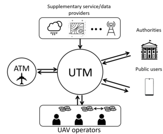
Unmanned aircraft system traffic management (UTM) is an air traffic management ecosystem under development for autonomously controlled operations of unmanned aerial systems (UAS) by the FAA, NASA, other federal partner agencies, and industry. They are collaboratively exploring concepts of operation, data exchange requirements, and a supporting framework to enable multiple UAS operations beyond visual line-of-sight at altitudes under 400 ft above ground level in airspace where FAA air traffic services are not provided.

<span class="mw-page-title-main">Applied Aeronautics</span> American drone manufacturer

Applied Aeronautics is a commercial drone manufacturer. Founded in 2014, Applied Aeronautics is headquartered in Austin, Texas. Applied Aeronautics is a manufacturer of affordable drones and drone related accessories for commercial and government customers. Their flagship product is the Albatross, an electric, long-range, fixed wing UAV.

A weather drone, or weather-sensing uncrewed aerial vehicle (UAV), – is a remotely piloted aircraft weighing less than 25 kg and carrying sensors that collect thermodynamic and kinematic data from the mid and lower atmosphere.

References

  1. "About ARCAA". Archived from the original on 28 December 2010. Retrieved 14 December 2010.
  2. "New aerospace research centre takes flight".
  3. Campion, Elouise (7 December 2006). "QUEENSLAND SET TO SOAR WITH PILOTLESS PLANES". Queensland Government. Retrieved 27 March 2024.
  4. "ResQu". Archived from the original on 12 November 2013. Retrieved 12 November 2013.