Avellino eruption

Last updated
Avellino Eruption
SheridanVesuviusFootprints.jpg
Thousands of footprints in the pyroclastic surge deposits of the Avellino eruption testify to an en masse exodus from the disaster zone.
Volcano Mount Vesuvius
Date1995±10 BC
Type Ultra-Plinian
Location Naples, Campania, Italy
40°49′N14°24′E / 40.817°N 14.400°E / 40.817; 14.400
VEI 6
ImpactDevastated and preserved Italian Bronze Age settlements within and throughout the area.
SheridanVesuviusHut.jpg
Hut at the site of the village

The Avellino eruption of Mount Vesuvius occurred in c. 1995 BC. [1] It is estimated to have had a VEI of 6, making it larger and more catastrophic than Vesuvius's more famous and well-documented 79 AD eruption. It is the source of the Avellino pumice (Italian : Pomici di Avellino) deposits extensively found in the comune of Avellino in Campania.

Contents

Characteristics of the eruption

The "assessment of volcanological factors" in one scientific study reconstructs a minimum eruption time of 3 hours in which an initial explosion raised a column of ash 23 km (75,000 ft) and deposited about 0.32 km3 of white pumice ("the white pumice phase"), while a second, more intense explosion raised a column to 31 km (102,000 ft) depositing 1.25 km3 of grey pumice ("the grey pumice phase"). These pumices appearing in Apulian pottery can be used to establish the relative chronology of pottery phases. [2]

A 2008 study of the lithofacies (deposits from the eruption) distinguishes three phases. Pyroclastic flows (PDC's) of Phases 1 and 2 were generated by "magmatic fragmentation" and had "small dispersal areas" mainly on the slopes of Vesuvius. Phase 3 was created by "phreatomagmatic fragmentation," in which clastic fragments are driven by superheated steam from ground water mixed with the other gases released from the magma. The authors characterize Phase 3 as "the most voluminous and widespread in the whole of Somma-Vesuvius's eruptive history." Some facies a few cm thick were found 25 km (16 mi) from the source. [3] The vent was 2 km (1.2 mi) west of today's center.

The overall results of the Avellino eruption were catastrophic and widespread. The deposit thickness of ash and other eruptive material ranges from 15m close to the vent to 50 cm around Avellino, and creating a subaquaeous debris-flow in the bay of Naples. [4]

Date of the eruption

The date of the Avellino eruption remains to be determined with a precision greater than about 500 years within the framework of the Early/Middle Bronze Age. A range of 2000–1500 BC includes the great majority of estimates. Ample opportunity to obtain Carbon-14 dates from charcoal and soil buried under the deposits has existed and still exists. Sporadic radiocarbon dating continues, with each scientist claiming to have obtained "the latest". Consistency with previous and subsequent work remains elusive. Since a real and very precise calendar date of the eruption must have existed, variation in estimations can only be the result of limitations to the carbon-dating method, which, given a plenitude of reliably emplaced samples, can only produce a date within a window of roughly 500 years in a maximum elapsed time of roughly 4000 years or 18 (12.5%).

According to Giardino, the problem of establishing a reliable date results from the differences of calibration – organic samples (such as charcoal: 1880–1680 BC) versus soil facies (1684–1535 BC). He prefers the earlier as the more reliable date. The Avellino Eruption separates archaeologically the Early Bronze Age in Campania from the Middle Bronze Age. [5]

A study published in 1990 by Vogel and others suggested that the Avellino eruption partly caused the climatic disturbances of the 1620s BC, dates verified by tree-ring series and ice-core layers. The authors had just obtained carbon dates of 3360±40 BP, or 1617–1703 calibrated BC. They were suggesting a coincidence of a number of eruptions, such as the Minoan eruption on Santorini. [6] The hypothesis remains unverifiable a generation later, due to the overall imprecision of the dates.

The Nola bronze-age village

The eruption destroyed several Bronze Age settlements. The remarkably well-preserved remains of one were discovered in May 2001 at Croce del Papa near Nola by French and Italian archaeologists, with huts, pots, livestock and even the footprints of animals and people, as well as skeletons. The residents had hastily abandoned the village, leaving it to be buried under pumice and ash in much the same way Pompeii was later preserved. [7] [8]

See also

Related Research Articles

<span class="mw-page-title-main">17th century BC</span> Century

The 17th century BC was the century that lasted from 1700 BC to 1601 BC.

<span class="mw-page-title-main">Mount Vesuvius</span> Active stratovolcano in the Gulf of Naples, Italy

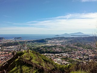
Mount Vesuvius is a somma-stratovolcano located on the Gulf of Naples in Campania, Italy, about 9 km (5.6 mi) east of Naples and a short distance from the shore. It is one of several volcanoes forming the Campanian volcanic arc. Vesuvius consists of a large cone partially encircled by the steep rim of a summit caldera, resulting from the collapse of an earlier, much higher structure.

<span class="mw-page-title-main">Lipari</span> Comune in Sicily, Italy

Lipari is a comune including six of seven islands of the Aeolian Islands and it is located in the Tyrrhenian Sea off the northern coast of Sicily, southern Italy; it is administratively part of the Metropolitan City of Messina. Its population is 12,821, but during the May to September tourist season, the total population may reach up to 20,000. It is also the name of the biggest island in the archipelago, where the main urban area of the comune is located.

Vitrification is the full or partial transformation of a substance into a glass, that is to say, a non-crystalline amorphous solid. Glasses differ from liquids structurally and glasses possess a higher degree of connectivity with the same Hausdorff dimensionality of bonds as crystals: dimH = 3. In the production of ceramics, vitrification is responsible for their impermeability to water.

<span class="mw-page-title-main">Volcanism of Italy</span> Volcanic activity in Italy

The volcanism of Italy is due chiefly to the presence, a short distance to the south, of the boundary between the Eurasian Plate and the African Plate. Italy is a volcanically active country, containing the only active volcanoes in mainland Europe. The lava erupted by Italy's volcanoes is thought to result from the subduction and melting of one plate below another.

The Apennine culture is a technology complex in central and southern Italy from the Italian Middle Bronze Age. In the mid-20th century the Apennine was divided into Proto-, Early, Middle and Late sub- phases, but now archaeologists prefer to consider as "Apennine" only the ornamental pottery style of the later phase of Middle Bronze Age (BM3). This phase is preceded by the Grotta Nuova facies and by the Protoapennine B facies and succeeded by the Subapennine facies of 13th-century. Apennine pottery is a burnished ware incised with spirals, meanders and geometrical zones, filled with dots or transverse dashes. It has been found on Ischia island in association with LHII and LHIII pottery and on Lipari in association with LHIIIA pottery, which associations date it to the Late Bronze Age as it is defined in Greece and the Aegean.

<span class="mw-page-title-main">Phlegraean Fields</span> Supervolcano located west of Naples, Italy

The Phlegraean Fields is a large volcanic caldera situated to the west of Naples, Italy. It is part of the Campanian volcanic arc, which includes Mount Vesuvius on the east side of Naples. The Phlegraean Fields is monitored by the Vesuvius Observatory. It was declared a regional park in 2003.

<span class="mw-page-title-main">Avellino</span> Comune in Campania, Italy

Avellino is a town and comune, capital of the province of Avellino in the Campania region of southern Italy. It is situated in a plain surrounded by mountains 47 kilometres (29 mi) east of Naples and is an important hub on the road from Salerno to Benevento.

<span class="mw-page-title-main">Minoan eruption</span> Major volcanic eruption around 1600 BCE

The Minoan eruption was a catastrophic volcanic eruption that devastated the Aegean island of Thera circa 1600 BCE. It destroyed the Minoan settlement at Akrotiri, as well as communities and agricultural areas on nearby islands and the coast of Crete with subsequent earthquakes and paleotsunamis. With a Volcanic Explosivity Index (VEI) of between 6 and 7, it resulted in the ejection of approximately 28–41 km3 (6.7–9.8 cu mi) of dense-rock equivalent (DRE), the eruption was one of the largest volcanic events in human history. Since tephra from the Minoan eruption serves as a marker horizon in nearly all archaeological sites in the Eastern Mediterranean, its precise date is of high importance and has been fiercely debated among archaeologists and volcanologists for decades, without coming to a definite conclusion.

<span class="mw-page-title-main">Gyali</span> Island in Greece

Gyali is a Greek volcanic island in the Dodecanese, located halfway between the south coast of Kos (Kardamaina) and Nisyros. It consists of rhyolitic obsidian lava domes and pumice deposits. No historical eruptions are known, but the most recent pumice eruptions overlie soils containing pottery and obsidian artifacts from the Neolithic period. The island has two distinct segments, with the northeastern part almost entirely made of obsidian and the southwestern part of pumice. These are connected by a narrow isthmus and beach made of modern reef sediments. Anciently, the island was known as Istros.

Dense-rock equivalent (DRE) is a volcanologic calculation used to estimate volcanic eruption volume. One of the widely accepted measures of the size of a historic or prehistoric eruption is the volume of magma ejected as pumice and volcanic ash, known as tephra during an explosive phase of the eruption, or the volume of lava extruded during an effusive phase of a volcanic eruption. Eruption volumes are commonly expressed in cubic kilometers (km3).

<span class="mw-page-title-main">Prehistoric Italy</span> Prehistory of Italy

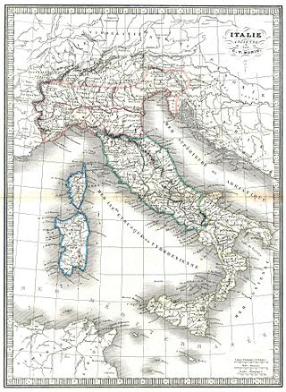
The prehistory of Italy began in the Paleolithic period, when species of Homo colonized the Italian territory for the first time, and ended in the Iron Age, when the first written records appeared in Italy.

<span class="mw-page-title-main">Middle Bronze Age Cold Epoch</span> Period of unusually cold climate in the North Atlantic region

The Middle Bronze Age Cold Epoch was a period of unusually cold climate in the North Atlantic region that lasted about from 1800 BC to 1500 BC. It was followed by the Bronze Age Optimum.

<span class="mw-page-title-main">Pompeii</span> Ancient Roman city near modern Naples, Italy

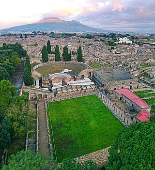
Pompeii was an ancient city located in what is now the comune of Pompei near Naples in the Campania region of Italy. Pompeii, along with Herculaneum and many villas in the surrounding area, was buried under 4 to 6 m of volcanic ash and pumice in the eruption of Mount Vesuvius in 79 AD.

<span class="mw-page-title-main">Herculaneum</span> Roman town destroyed by eruption of Mount Vesuvius

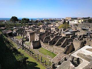
Herculaneum was an ancient Roman town, located in the modern-day comune of Ercolano, Campania, Italy. Herculaneum was buried under volcanic ash and pumice in the Eruption of Mount Vesuvius in 79 AD.

<span class="mw-page-title-main">Nola</span> Comune in Campania, Italy

Nola is a town and a municipality in the Metropolitan City of Naples, Campania, southern Italy. It lies on the plain between Mount Vesuvius and the Apennines. It is traditionally credited as the diocese that introduced bells to Christian worship.

<span class="mw-page-title-main">Eruption of Mount Vesuvius in 79 AD</span> Eruption of a stratovolcano in southern Italy during the Roman Empire

Of the many eruptions of Mount Vesuvius, a major stratovolcano in southern Italy, the best-known is its eruption in 79 AD, which was one of the deadliest.

<span class="mw-page-title-main">Mount Barbaro</span> Mountain in Italy

Mount Barbaro or Mount Gauro in Italy Monte Barbaro or Monte Gauro, is one of the eruptive vents of the Phlegraean Fields, a volcanic field of Italy located in Campania.

<span class="mw-page-title-main">Campanian Ignimbrite eruption</span> Volcanic eruption about 40,000 years ago

The Campanian Ignimbrite eruption was a major volcanic eruption in the Mediterranean during the late Quaternary, classified 7 on the Volcanic Explosivity Index (VEI). The event has been attributed to the Archiflegreo volcano, the 12-by-15-kilometre-wide caldera of the Phlegraean Fields, located 20 km (12 mi) west of Mount Vesuvius under the western outskirts of the city of Naples and the Gulf of Pozzuoli, Italy. Estimates of the date and magnitude of the eruption(s), and the amount of ejected material have varied considerably during several centuries the site has been studied. This applies to most significant volcanic events that originated in the Campanian Plain, as it is one of the most complex volcanic structures in the world. However, continued research, advancing methods, and accumulation of volcanological, geochronological, and geochemical data have improved the dates' accuracy.

<span class="mw-page-title-main">Kurile Lake</span> Caldera lake in the Kamchatka peninsula, Russia

Kurile Lake is a caldera and crater lake in Kamchatka, Russia. It is also known as Kurilskoye Lake or Kuril Lake. It is part of the Eastern Volcanic Zone of Kamchatka which, together with the Sredinny Range, forms one of the volcanic belts of Kamchatka. These volcanoes form from the subduction of the Pacific Plate beneath the Okhotsk Plate and the Asian Plate.

References

  1. Sevink, Jan; et al. (2011), "Robust date for the Bronze Age Avellino eruption (Somma-Vesuvius): 3945 ± 10 calBP (1995 ± 10 calBC)", Quaternary Science Reviews, 30 (9–10): 1035–1046, Bibcode:2011QSRv...30.1035S, doi:10.1016/j.quascirev.2011.02.001
  2. Cioni, Raffaello; Levi, Sara; Sulpizio, Roberto (2000). "Apulian Bronze Age pottery as a long-distance indicator of the Avellino Pumice eruption (Vesuvius, Italy) — Abstract". Geological Society, London, Special Publications. London: Geological Society. 171 (1): 159–177. Bibcode:2000GSLSP.171..159C. doi:10.1144/GSL.SP.2000.171.01.13. S2CID   129583954.
  3. Sulpizio, R.; Bonasia, R.; Dellino, P.; Mele, D.; Di Vito, M. A.; La Volpe, L. (23 February 2010). "The Pomici di Avellino eruption of Somma–Vesuvius (3.9 ka BP). Part II: sedimentology and physical volcanology of pyroclastic density current deposits — Abstract". Bulletin of Volcanology. Springer. 72 (5): 559. Bibcode:2010BVol...72..559S. doi:10.1007/s00445-009-0340-4. S2CID   129725019.
  4. Giuseppe Mastrolorenzo; Pierpaolo Petrone; Lucia Pappalardo; Michael F. Sheridan (January 2006). "The Avellino 3780-yr-B.P. catastrophe as a worst-case scenario for a future eruption at Vesuvius". Proceedings of the National Academy of Sciences of the United States of America. 103 (12): 4366–4370. Bibcode:2006PNAS..103.4366M. doi: 10.1073/pnas.0508697103 . PMC   1450177 . PMID   16537390.
  5. Giardino 2005 , pp. 628–629
  6. Vogel, J. S.; Cornell, W.; Nelson, D.E.; Southon, J.R. (1990). "Letters to Nature: Vesuvius/Avellino, one possible source of seventeenth century BC climatic disturbances — Abstract". Nature . Nature Publishing Group. 344 (6266): 534–537. Bibcode:1990Natur.344..534V. doi:10.1038/344534a0. S2CID   4368499.
  7. "An ancient Bronze Age village and a bucket (3500 bp) destroyed by the pumice eruption in Avellino (Nola-Campania)". Archived from the original on 2012-06-18. Retrieved 2006-12-08.
  8. "Vesuvius' Next Eruption May Put Metro Naples at Risk – Lesson from Katrina is need to focus on "maximum probable hazard"". State University of New York. Archived from the original on 24 December 2006. Retrieved 2006-12-08.

Bibliography