Averill Park, New York

Last updated
Averill Park, New York
CDP
2014-08-28 13 31 47 View east along West Sand Lake Road (New York State Route 43) in the Averill Park section of Sand Lake, New York.JPG
View east along NY 43 in Averill Park
Rensselaer County New York incorporated and unincorporated areas Averill Park highlighted.svg
Location in Rensselaer County and the state of New York.
USA New York location map.svg
Red pog.svg
Averill Park, New York
Location within the state of New York
Coordinates: 42°38′10″N73°33′16″W / 42.63611°N 73.55444°W / 42.63611; -73.55444
Country United States
State New York
County Rensselaer
Town Sand Lake
Area
[1]
  Total4.16 sq mi (10.77 km2)
  Land4.04 sq mi (10.46 km2)
  Water0.12 sq mi (0.32 km2)
Elevation
784 ft (239 m)
Population
 (2020)
  Total2,098
  Density519.69/sq mi (200.66/km2)
Time zone UTC-5 (Eastern (EST))
  Summer (DST) UTC-4 (EDT)
ZIP code
12018
Area code 518
FIPS code 36-03320
GNIS feature ID0942730

Averill Park is a census-designated place within the town of Sand Lake in Rensselaer County, New York, United States. The population was 2,098 at the 2020 census.

Contents

The community is named after the local Averill family. [2] It is located on Route 43, south of Crystal Lake and east of West Sand Lake.

The Sand Lake Baptist Church was listed on the National Register of Historic Places in 2004. [3]

Demographics

Historical population
CensusPop.Note
2000 1,517
2010 1,69311.6%
2020 2,09823.9%
U.S. Decennial Census [4]

History

Originally known only as part of greater Sand Lake, the community along with neighboring towns grew with the nineteenth-century development of wool and cotton textile manufacturing by local watermills and knitting factories along the Wynants Kill tributary of the Hudson River. [5] By the 1880s, several independent local mills produced hosiery, undergarments, and knit shirts. [6]

The hamlet was named Averill in 1880 after a local leading family, then in 1882 renamed Averill Park in promotion of local summer-resort development [7] and of the Troy & New England Railway, a never-completed trolley and freight line intended to connect the city of Troy, New York with the mills and summer resorts of Averill Park and its “upstate Coney Island” recreational Crystal Lake Beach, and with the mills of the neighboring town of West Sand Lake. [8]

The local mills declined after the increasing efficiency of steam and electrical power improved competition from regional factories, and were then destroyed by a 1891 river flood. The Faith Knitting Company (later Faith Mills), founded in 1897, restored local industry by buying and re-equipping the old mills and rehiring local labor. [9] Other late-nineteenth- and early-twentieth-century firms included Jake Warger’s Dry Goods Store; Gilbert Beebe’s blacksmith shop; Stout’s Hardware; and Park Pharmacy, where Jerry Lewis worked as a soda jerk in 1942 when his father was a superintendent at Faith Mills. [10]

Mid-nineteenth- to early twentieth-century seasonal hotels included Al’s Place, Hilke’s Averill Park Hotel (previously housing Scram’s Collegiate Institute), Traveler’s Rest (aka Sand Lake House, Tillotson’s Hotel, and Wagner’s Hotel), the Lake View Hotel (aka Blake’s and the Gabler Hotel, later housing the Averill Park Female Seminary), and Clum’s. For mill workers and townspeople, Faith Mills’s Clubhouse was “the entertainment center of the town for many years,” [11] complete with dance hall, motion picture parlor, cafeteria, bowling alleys, pocket billiard room, and shower room. [12]

Faith Mills’s decline, and with it that of Averill Park, began in the Great Depression, during which local textile mills did not regain business till 1932. [13] During World War II, manufacture of wool blankets and long woolen underwear for the military earned Faith Mills four rare “excellence in production” Army-Navy "E" Awards. [14] [15]

From 1955 to 1962, Faith Mills, by then one of only three remaining U.S. manufacturers of woolen long underwear “considered obsolete by most persons” as the market shifted to cotton undergarments, was sold to holding companies and downsized to one factory in Averill Park employing as few as 54 workers, finally closing in 1962. [16] [17] [18] [19] In 1965, the factory was to manufacture a “floor-sweeping compound” and become a warehouse for corrugated shipping containers, employing 15 workers. [20]


2010 demographics

As of the census [21] of 2010, The racial makeup of the CDP was 85.4% White, 6.5% African American, 4.1% Asian, and 4.0% from two or more races. Hispanic or Latino of any race were 7.4% of the population.

There were 571 households in the CDP, out of which 41.0% had children under the age of 18 living with them, 58.2% were married couples living together, 12.2% had a female householder with no husband present, and 26.4% were non-families. 20.2% of all households were made up of individuals, and 9.7% had someone living alone who was 65 years of age or older. The average household size was 2.68 and the average family size was 3.09. In the CDP, the population was spread out, with 28.8% under the age of 18, 7.9% from 18 to 24, 24.3% from 25 to 44, 29.7% from 45 to 64, and 9.3% who were 65 years of age or older. The median age was 39 years. For every 100 females, there were 93.7 males. For every 100 females age 18 and over, there were 93.9 males. The median income for a household in the CDP was $44,000, and the median income for a family was $49,367. Males had a median income of $34,909 versus $26,890 for females. The per capita income for the CDP was $26,226. About 8.0% of families and 17.3 of the population were below the poverty line, including 10.4% of those under age 18 and 19.1% of those age 65 or over.

2000 demographics

As of the census [21] of 2000, there were 1,517 people, 597 households, and 420 families residing in the CDP. The population density was 507.2 inhabitants per square mile (195.8/km2). There were 628 housing units at an average density of 210.0 per square mile (81.1/km2). The racial makeup of the CDP was 96.89% White, 1.26% African American, 1.46% Asian, and 1.38% from two or more races. Hispanic or Latino of any race were 2.99% of the population.

Schools

Climate

This climatic region is typified by large seasonal temperature differences, with warm to hot (and often humid) summers and cold (sometimes severely cold) winters. According to the Köppen Climate Classification system, Averill Park has a humid continental climate, abbreviated "Dfb" on climate maps. [22]

Sites of interest

Arts Letters & Numbers, on Burden Lake Road, is a nonprofit arts center offering workshops, performances, and residencies, [23] housed in a complex including the former Sand Lake Cotton Factory, which operated as Arnolds, Hunt & Co. until 1875 and was later run by Faith Mills; and also the residence built by mill owner George Arnold. [24]

Hollywood Drive-In Theatre, on New York State Route 66, is a four-hundred-car drive-in theater built in 1952. [25]

Related Research Articles

<span class="mw-page-title-main">Westchester County, New York</span> County in New York, United States

Westchester County is located in the U.S. state of New York. It is the seventh most populous county in the State of New York and the most populous north of New York City. According to the 2020 United States Census, the county had a population of 1,004,456, its highest decennial count ever and an increase of 55,344 (5.8%) from the 949,113 counted in 2010. Located in the Hudson Valley, Westchester covers an area of 450 square miles (1,200 km2), consisting of six cities, 19 towns, and 23 villages. Established in 1683, Westchester was named after the city of Chester, England. The county seat is the city of White Plains, while the most populous municipality in the county is the city of Yonkers, with 211,569 residents per the 2020 U.S. Census.

<span class="mw-page-title-main">Rensselaer County, New York</span> County in New York, United States

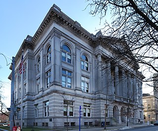
Rensselaer County is a county in the U.S. state of New York. As of the 2020 census, the population was 161,130. Its county seat is Troy. The county is named in honor of the family of Kiliaen van Rensselaer, the original Dutch owner of the land in the area.

<span class="mw-page-title-main">New Preston, Connecticut</span> Census-designated place in Connecticut, United States

New Preston is a rural village and census-designated place (CDP) in the northwest corner of the town of Washington, Litchfield County, Connecticut, United States. As of the 2010 census, the population of the New Preston CDP was 1,182, out of 3,578 in the entire town of Washington.

<span class="mw-page-title-main">Houghton Lake, Michigan</span> Census-designated place & unincorporated community in Michigan, United States

Houghton Lake is an unincorporated community and census-designated place (CDP) in Roscommon County in the U.S. state of Michigan. The population was 5,294 at the time of the 2020 census, making it the largest unincorporated community in Northern Michigan. The CDP is located within Denton, Lake, and Roscommon townships.

<span class="mw-page-title-main">Orange Lake, New York</span> CDP in New York, United States

Orange Lake is a hamlet in Orange County, New York, United States. The population was 9,770 at the 2020 census. It is part of the Newburgh–Middletown, NY Metropolitan Statistical Area as well as the larger New York–Newark–Bridgeport, NY-NJ-CT-PA Combined Statistical Area.

<span class="mw-page-title-main">North Greenbush, New York</span> Town in New York, United States

North Greenbush is a town in Rensselaer County, New York, United States. North Greenbush is located in the western part of the county. The population was 13,292 at the 2020 census.

<span class="mw-page-title-main">Sand Lake, New York</span> Town in New York, United States

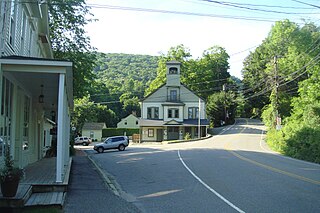
Sand Lake is a town in south-central part of Rensselaer County, New York, United States. Sand Lake is about 13 miles east of Albany, New York. Within the town are three hamlets: Averill Park, Glass Lake and the hamlet of Sand Lake. Its four lakes are a source of recreation. Many commercial enterprises of the 19th century and into the 20th century relied on power generated from the Wynants Kill Creek and Burden Lake mills. The area is known for fertile soil for grazing and agriculture. The estimated population for 2016 census was 8,490.

<span class="mw-page-title-main">Wynantskill, New York</span> CDP in New York, United States

Wynantskill is a census-designated place (CDP) in Rensselaer County, New York, United States. The population was 3,276 at the 2010 census. Wynantskill is located at the northern town line and the northeastern corner of the town of North Greenbush. The community is a suburb of Troy. state route 66 is the main route through the community. Wynantskill has a major grocery store, several banks and restaurants, a craft beverage store, convenience stores, a post office, and a bowling alley, with almost all houses located on side streets off Main Ave. Other major roads are Whiteview Road, a primarily residential road that leads to US 4; and West Sand Lake Road.

<span class="mw-page-title-main">Lake Ronkonkoma, New York</span> Hamlet and census-designated place in New York, United States

Lake Ronkonkoma is a hamlet and census-designated place (CDP) in Suffolk County, on Long Island, in New York, United States. The population was 20,155 at the 2010 census.

<span class="mw-page-title-main">Pine Hill, New York</span> CDP and hamlet in New York, United States

Pine Hill is a hamlet in the western part of the town of Shandaken in Ulster County, New York, United States. As of the 2020 census, the CDP had a total population of 275.

<span class="mw-page-title-main">Somers, New York</span> Town in New York, United States

Somers is a town located in northern Westchester County, New York, United States. As of the 2010 census, the town had a population of 20,434. The nearby Metro-North Commuter Railroad provides service to Grand Central Terminal in Manhattan with an average commute time of 65 to 75 minutes from stations at Purdys, Goldens Bridge, Croton Falls, and Katonah.

Anderson Mill is a neighborhood of Austin and a former census-designated place (CDP) in Travis and Williamson counties in the U.S. state of Texas. The population was 7,199 at the 2010 census.

<span class="mw-page-title-main">Poestenkill, New York</span> Town in New York, United States

Poestenkill is a town in Rensselaer County, New York, United States. The population was 4,530 at the 2010 census. The town is southeast of Troy and is centrally located in the county.

<span class="mw-page-title-main">Burden Iron Works</span> United States historic place

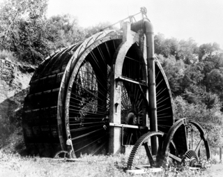
The Burden Iron Works was an iron works and industrial complex on the Hudson River and Wynantskill Creek in Troy, New York. It once housed the Burden Water Wheel, the most powerful vertical water wheel in history. It is widely believed that George Washington Gale Ferris Jr., inventor of the Ferris wheel, had occasion to observe the wheel while a student at Rensselaer Polytechnic Institute. The iron works site was listed on the National Register of Historic Places as an archaeological site in 1977. The Burden Ironworks Office Building was previously listed in 1972.

<span class="mw-page-title-main">Hampton Beach, New Hampshire</span> Census-designated place in New Hampshire, United States

Hampton Beach is a village district, census-designated place, and beach resort in the town of Hampton, New Hampshire, United States, along the Atlantic Ocean. Its population at the 2020 census was 2,598. Hampton Beach is in Rockingham County, about 15 miles (24 km) south of Portsmouth. The community is a popular tourist destination and the busiest beach community in New Hampshire. Ocean Boulevard, the main street along the beach, includes a boardwalk, many shops and businesses, several seasonal hotels, and the Hampton Beach Casino Ballroom, which hosts national acts in the summer. Hampton Beach State Park was named one of four "Superstar" beaches in the United States in 2011, for having had perfect water-quality testing results in each of the previous three years.

<span class="mw-page-title-main">New York State Route 43</span> State highway in Rensselaer County, New York, US

New York State Route 43 (NY 43) is a state highway in Rensselaer County, New York, in the United States. It extends for 24.00 miles (38.62 km) from Interstate 90 (I-90) exit 8 in North Greenbush to the Massachusetts state line, where it continues into Williamstown as Massachusetts Route 43. Most of NY 43 is a two-lane highway that passes through a mixture of rural and residential areas; however, its westernmost 2 miles (3.2 km) between I-90 and U.S. Route 4 (US 4) is a four-lane divided highway. NY 43 has an overlap with NY 66 in Sand Lake and intersects NY 22 in Stephentown.

<span class="mw-page-title-main">New York State Route 66</span> State highway in New York, US

New York State Route 66 (NY 66) is a state highway in the Capital District of New York in the United States. The route begins at an intersection with US 9 and NY 23B in the Columbia County city of Hudson and ends at a junction with NY 2 in the Rensselaer County city of Troy. While both Hudson and Troy are located on the Hudson River, NY 66 follows a more inland routing between the two locations to serve several rural villages and hamlets, including Chatham and Sand Lake. NY 66 overlaps with U.S. Route 20 (US 20) and NY 43, two regionally important east–west highways, in Nassau and Sand Lake, respectively.

The Wynants Kill is a 15.8-mile-long (25.4 km) stream which has its source at Glass Lake near Averill Park, New York, and terminates at the Hudson River at Troy, New York.

The Troy and New England Railway Company was an electric trolley that operated between Averill Park and Albia. Riders could pick up the trolley from Troy's city trolley. It operated around 1895 to 1925. James K. Averill had this line established, with the intention to extending the route to Pittsfield, Massachusetts.

References

  1. "ArcGIS REST Services Directory". United States Census Bureau. Retrieved September 20, 2022.
  2. University of the State of New York Bulletin. University of the State of New York. 1914. p. 50.
  3. "National Register Information System". National Register of Historic Places . National Park Service. July 9, 2010.
  4. "Census of Population and Housing". Census.gov. Retrieved June 4, 2016.
  5. Harris, Robert Dalton; DeBlois, Diane (2005). "Geographic Integration of Industry on the Wynants Kill, 1816-1911" (PDF). Business and Economic History On-Line. The Business History Conference. 3. Retrieved January 30, 2020.
  6. "Sand Lake -- Mill Town?". Historical Highlights. Sand Lake Historical Society. Winter 2000. Retrieved January 30, 2020.
  7. Bob, Lilly (Spring 2003). "'Averill'". Historical Highlights. Vol. 20, no. 3. Sand Lake Historical Society. Retrieved January 30, 2020.
  8. Ballard, Charles L.; DiCarlo, Gino (2011). "A Brief Sketch of the Troy & New England Railway". Gino’s Rail Page. Originally printed in The Call Board, newsletter of the Mohawk and Hudson Chapter of the National Railway Historical Society. Retrieved January 30, 2020.
  9. Harris, Robert Dalton; DeBlois, Diane (2005). "Geographic Integration of Industry on the Wynants Kill, 1816-1911" (PDF). Business and Economic History On-Line. The Business History Conference. 3. Retrieved January 30, 2020.
  10. French, Mary D.; Lilly, Robert J. (2001). Sand Lake. Charleston, SC: Arcadia. ISBN   9780738505404.
  11. French, Mary D.; Lilly, Robert J. (2001). Sand Lake. Charleston, SC: Arcadia. ISBN   9780738505404.
  12. Harris, Robert Dalton; DeBlois, Diane (2005). "Geographic Integration of Industry on the Wynants Kill, 1816-1911" (PDF). Business and Economic History On-Line. The Business History Conference. 3. Retrieved January 30, 2020.
  13. "Parade Back to Jobs Gains Speed Daily" . Daily News. New York. July 22, 1932. p. 15. Retrieved January 30, 2020 via Newspapers.com.
  14. "Faith Mills Given 'E' Award for Splendid Record in Production" . Times Record. Troy, NY. December 31, 1943. p. 3. Retrieved January 30, 2020 via Newspapers.com.
  15. "Fourth Federal Award Received by Faith Mills" . Troy Record. Troy, NY. August 14, 1945. p. 9. Retrieved January 30, 2020 via Newspapers.com.
  16. "Two Holding Companies Purchase Faith Mills, Inc" . Times Record. Troy, NY. October 1, 1955. p. 3. Retrieved January 30, 2020 via Newspapers.com.
  17. Goodwin, Hilda (May 21, 1962). "Averill Park's Faith Mills to Close After 65 Years" . Troy Record. Troy, NY. p. 18. Retrieved January 30, 2020 via Newspapers.com.
  18. Roy, Retzlaff (July 24, 1962). "150 to Work as Mills Reopen in Averill Park" . Troy Record. Troy, NY. p. 20. Retrieved January 30, 2020 via Newspapers.com.
  19. "Souhan Buys Troy Firm" . Democrat and Chronicle. Rochester, NY. July 29, 1962. p. 2B. Retrieved January 30, 2020 via Newspapers.com.
  20. "New Owner Takes Over Faith Mills" . Troy Record. Troy, NY. November 17, 1965. Retrieved January 30, 2020 via Newspapers.com.
  21. 1 2 "U.S. Census website". United States Census Bureau . Retrieved 2008-01-31.
  22. Climate Summary for Averill Park, New York
  23. "About". Arts Letters & Numbers. Retrieved January 31, 2020.
  24. "Sand Lake -- Mill Town?". Historical Highlights. Sand Lake Historical Society. Winter 2000. Retrieved January 31, 2020.
  25. "Hollywood Drive-In". Cinema Treasures. Retrieved January 31, 2020.