B65 (New York City bus)

Last updated
b65
Bergen Street Line
9511 B65.jpg
XDE40 on the B65
Overview
System MTA Regional Bus Operations
Operator New York City Transit Authority
Garage East New York Depot
Vehicle New Flyer Xcelsior XD40
New Flyer Xcelsior XDE40
OBI Orion VII NG HEV
Route
Locale Brooklyn, New York, U.S.
Start Downtown Brooklyn   Fulton Mall/Jay Street–MetroTech station
ViaBergen/Dean Streets
End Crown Heights– Ralph Avenue
Length3.6 miles (5.8 km)
Other routes B45 St. Johns Place
Service
OperatesAll times except late nights [1]
Annual patronage718,002 (2023) [2]
TransfersYes
Timetable B65
  B64  {{{system_nav}}}  B67  

The Bergen Street Line is a public transit line in Brooklyn, New York City, running westbound mostly along Bergen Street, as well as eastbound on Dean Street (as part of a one-way pair), between Downtown Brooklyn and Ocean Hill (earlier Red Hook to City Line). Originally a streetcar line, it is now the B65 bus route, operated by the New York City Transit Authority. The B65 is based out of the East New York Depot in East New York, Brooklyn.

Contents

Route description

The B65 starts at Boerum Place and Joralemon Street. The eastbound route runs down Boerum Place and makes a left at Atlantic Avenue. It runs down Atlantic Avenue to 3rd Avenue and proceeds to make a right turn and run down Third Avenue for two blocks before turning left on Dean Street. The route then proceeds east on Dean Street until it reaches Rochester Avenue and then turns right on Rochester Avenue. The route then takes another left at St. Marks Avenue. It runs down St Marks Avenue until Ralph Avenue where it makes a right turn and runs down Ralph Avenue until St Johns Place, where it terminates along with the B45.

The westbound B65 starts at St Johns Place and runs down St Johns Place for one block and makes a right turn on Buffalo Avenue and runs down Buffalo Avenue until Bergen Street, where it makes a left turn on Bergen Street. It runs down Bergen Street until Smith Street, where it makes a right turn on Smith Street. It then runs up Smith Street until Livingston Street, where it terminates.

History

A museum bus on the B65 route lays over at the eastern terminus in Ocean Hill. NYC Transit Authority GMC Blitz T6H-5305A 5227.jpg
A museum bus on the B65 route lays over at the eastern terminus in Ocean Hill.

The South Brooklyn and Bergen Street Railroad was organized under the general railroad law [3] and opened by 1865 from Hamilton Ferry along Sackett Street (including part of the Brooklyn City Rail Road's Furman Street Line), Hoyt Street, and Bergen Street to Classon Avenue. [4] [5] The Bergen Street Railroad was merged into the Brooklyn and Canarsie Railroad, [6] and on September 21, 1866 an extension to Canarsie Landing (where steamboats connected for Rockaway) along Bergen Street, Nostrand Avenue, Clove Road, Little Lane, and Canarsie's main street (the last three partially gone) [7] was opened. [8] It was the second line to Canarsie, arriving a year after the Brooklyn and Rockaway Beach Railroad, and was a failure, being foreclosed on January 13, 1868. The original portion, west of the stables at Bergen Street and Classon Avenue, was sold on February 14, 1868; [9] the rest was sold on September 15, 1868. [7] None of the extension to Canarsie was ever used again.

The South Brooklyn and Park Railroad acquired the line to Classon Avenue on June 1, 1870, [10] and was again sold on June 19, 1877 [11] as the South Brooklyn Central Railroad. It was authorized in 1878 to build a branch in Bergen Street from Hoyt Street west to Court Street, use the Brooklyn City Railroad trackage in Court Street, and use the Atlantic Avenue Railroad trackage in Atlantic Avenue and Furman Street to the Wall Street Ferry at Montague Street. [12] The Atlantic Avenue Railroad leased the South Brooklyn Central, then extending to Bergen Street and Albany Avenue, on February 2, 1885. [13] The Atlantic Avenue Railroad laid tracks in Boerum Place from Atlantic Avenue south to Bergen Street to connect the lines, as an extension of its Adams Street and Boerum Place Line.

The line reached Rochester Avenue by 1897. [14] Eventually the Bergen Street Line cars turned south on Buffalo Avenue, east on the St. Johns Place Line trackage along St. Johns Place and East New York Avenue, and east along Liberty Avenue to City Line.

At some point, the west end was truncated to the intersection of Smith Street and Sackett Street. Buses were substituted for streetcars on July 20, 1947, and were replaced again by trolley buses between October 17, 1948 and July 27, 1960. [15] The B65 bus has been truncated more, only running from Cobble Hill east to Ocean Hill; the B12 bus, started by the Brooklyn–Manhattan Transit Corporation as a new route in 1931, later covered Liberty Avenue out to City Line until it was truncated to Broadway Junction in 2010.

In the 1990s, the B65 was rerouted from Cobble Hill north to Downtown Brooklyn, terminating at the Fulton Mall.

On December 1, 2022, the MTA released a draft redesign of the Brooklyn bus network. [16] [17] As part of the redesign, B65 service west of Washington Avenue would be rerouted to serve Atlantic Avenue with the B45. B65 would also be shortened to Ralph Avenue and St. Marks Place. Service on Bergen and Dean Streets west of Washington Avenue would be discontinued. [18] Closely spaced stops would also be eliminated. [16] [17]

Related Research Articles

<span class="mw-page-title-main">L (New York City Subway service)</span> New York City Subway service

The L 14th Street–Canarsie Local is a rapid transit service in the B Division of the New York City Subway. Its route emblem, or "bullet", is colored medium gray since it serves the BMT Canarsie Line.

<span class="mw-page-title-main">Atlantic Avenue (New York City)</span> Avenue in Brooklyn and Queens, New York

Atlantic Avenue is a major thoroughfare in the New York City boroughs of Brooklyn and Queens. It stretches from the Brooklyn waterfront on the East River all the way to Jamaica, Queens. Atlantic Avenue runs parallel to Fulton Street for much of its course through Brooklyn, where it serves as a border between the neighborhoods of Prospect Heights and Fort Greene and between Bedford-Stuyvesant and Crown Heights, and between Brooklyn Heights and Cobble Hill. This stretch of avenue is known for having a high rate of pedestrian fatalities and has been described as "the killing fields of the city."

The BMT Canarsie Line is a rapid transit line of the B Division of the New York City Subway system, named after its terminus in the Canarsie neighborhood of Brooklyn. It is served by the L train at all times, which is shown in medium gray on the New York City Subway map and on station signs.

<span class="mw-page-title-main">B54 (New York City bus)</span> Bus route in Brooklyn, New York

The B54 is a bus route on Myrtle Avenue in Brooklyn, New York City. The line travels between Downtown Brooklyn in the west and Myrtle–Wyckoff Avenues station in the east. The B54 operates from MTA New York City Bus's Fresh Pond Depot in Ridgewood, Queens. The route serves only the section of Myrtle Avenue within Brooklyn; the section within Queens is served by the Q55 bus.

<span class="mw-page-title-main">B41 (New York City bus)</span> Bus route in Brooklyn, New York

The B41 is a bus route that constitutes a public transit line operating in Brooklyn, New York City, running along Flatbush Avenue between Downtown Brooklyn and Marine Park. The B41 is operated by the MTA New York City Transit Authority. Its precursor was a streetcar line that began operation in 1860, and was known as the Flatbush Avenue Line. The route became a bus line in 1951. Limited-stop service began along the route in 1992.

<span class="mw-page-title-main">B52 (New York City bus)</span> Bus route in Brooklyn, New York

The B52 is a bus route that constitutes a public transit line operating in Brooklyn, New York City, running mostly along Fulton Street, Greene Avenue, and Gates Avenue between Downtown Brooklyn and Ridgewood, Queens. The B52 is operated by the MTA New York City Transit Authority. Its precursor was a streetcar line that began operation by 1874, and was known as the Greene and Gates Avenues Line. The route became a bus line in 1941.

<span class="mw-page-title-main">B38 (New York City bus)</span> Bus route in Brooklyn, New York

The DeKalb Avenue Line is a public transit line in Brooklyn and Queens, New York City, running mostly along DeKalb Avenue, as well as eastbound on Lafayette Avenue, between Downtown Brooklyn and Ridgewood, Queens. Originally a streetcar line, it is now the B38 DeKalb/Lafayette Avenues bus route, operated by the New York City Transit Authority.

<span class="mw-page-title-main">B44 (New York City bus)</span> Bus route in Brooklyn, New York

The B44 is a public transit line in Brooklyn, New York City, running mostly along Nostrand Avenue, as well as northbound on Rogers Avenue or New York Avenue and Bedford Avenue, between Sheepshead Bay and Williamsburg. Originally a streetcar line, it is now the B44 bus route, operated by the New York City Transit Authority.

<span class="mw-page-title-main">Q59 (New York City bus)</span> Bus route in Queens and Brooklyn, New York

The Grand Street Line is a public transit line in Brooklyn and Queens, New York City, running mostly along the continuous Grand Street and Grand Avenue between Williamsburg, Brooklyn and Maspeth, Queens. It then continues down Queens Boulevard to the 63rd Drive–Rego Park station. Originally a streetcar line, it is now the Q59 bus route, operated by the New York City Transit Authority between Williamsburg and Rego Park, Queens.

The Hudson Avenue Line was a horse car street railway line in Brooklyn, New York City, United States, running mostly along Hudson Avenue in Vinegar Hill, near Downtown Brooklyn. It was short-lived, operating only from 1867 to 1871, but its trackage rights over the Brooklyn City Rail Road allowed the Atlantic Avenue Railroad to operate South Ferry-Prospect Park cars for many years.

<span class="mw-page-title-main">B69 (New York City bus)</span> Bus route in Brooklyn, New York

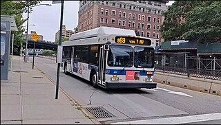
The B69 is a bus route that constitutes a public transit line operating in Brooklyn, New York City, running along 7th Avenue and Vanderbilt Avenue between Kensington and Dumbo. The B69 is operated by the MTA New York City Transit Authority. Its precursor was a streetcar line that began operation in 1869, and was known as the Vanderbilt Avenue Line. The route became a bus line in 1950.

<span class="mw-page-title-main">B45 (New York City bus)</span> Bus route in Brooklyn, New York

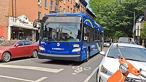
The B45 is a bus route that constitutes a public transit line operating in Brooklyn, New York City, mainly along Atlantic Avenue, Washington Avenue, Sterling Place, and St. Johns Place between Downtown Brooklyn and Crown Heights. It is operated by the MTA New York City Transit Authority. Its precursor was a streetcar line that began operation in 1877, and was known as the St. Johns Place Line. The route became a bus line in 1947.

<span class="mw-page-title-main">B63 (New York City bus)</span> Bus route in Brooklyn, New York

The B63 is a bus route in Brooklyn, New York City, running mainly along Fifth Avenue and Atlantic Avenue between Fort Hamilton and Cobble Hill. Originally a streetcar line called the Fifth Avenue Line, it is now operated by the New York City Transit Authority as the Fifth/Atlantic Avenues bus.

<span class="mw-page-title-main">B61 and B62 buses</span> Bus routes in Brooklyn, New York

The Crosstown Line is a public transit line in Brooklyn, New York City, running along Van Brunt Street and Manhattan Avenue between Red Hook and Long Island City, Queens. Originally a streetcar line, it is now the B61 and the B62 bus routes. The northern section, the B62, is operated by MTA New York City Bus' Grand Avenue Depot in Maspeth, Queens, and the southern section is the B61, operated by MTA New York City Bus' Jackie Gleason Depot in Sunset Park. The entire route was a single line, the B61, until January 3, 2010; the B62 was previously a separate, parallel route between Downtown Brooklyn and Greenpoint, now part of the B43 route. The streetcar line, B61 and the original B62 previously operated from the now-closed Crosstown Depot in Greenpoint.

<span class="mw-page-title-main">B103 (New York City bus)</span> Bus route in Brooklyn, New York

The B103 constitutes a bus route in the New York City borough of Brooklyn. Originally operated by Command Bus Company, the bus route is now operated by MTA Bus Company, running between Downtown Brooklyn and Canarsie.

<span class="mw-page-title-main">B43 (New York City bus)</span> Bus route in Brooklyn, New York

The Graham Avenue Line and Tompkins Avenue Line were two public transit lines in Brooklyn, New York City with the Graham Avenue Line running mainly along Graham Avenue and Manhattan Avenue and the Tompkins Avenue Line running mainly along Tompkins Avenue. The Graham Avenue line ran between Downtown Brooklyn and Greenpoint and the Tompkins Avenue Line ran between Prospect Lefferts Gardens and Williamsburg. Originally streetcar lines, they were replaced by the B47 and B62 bus routes which were then combined to form the B43 route which currently operates between Prospect Lefferts Gardens and Greenpoint. The line is dispatched from Jackie Gleason Depot in Sunset Park, Brooklyn.

<span class="mw-page-title-main">B48 (New York City bus)</span> Bus route in Brooklyn, New York

The B48 bus route constitutes a public transit line in Brooklyn, New York City, running along Lorimer Street, Franklin Avenue, and Classon Avenue between Flatbush and Greenpoint. Originally the Lorimer Street streetcar line, it is now a bus route operated by MTA New York City Bus.

The Adams Street and Boerum Place Line was a public transit line in Downtown Brooklyn, New York City, United States, running along Boerum Place and Adams Street. It served as access for the Atlantic Avenue Railroad to the City Hall area.

The Hicks Street Line was a public transit line in Brooklyn, New York City, United States, running from the Ninth Avenue Depot at Greenwood Cemetery to the Brooklyn Bridge.

<span class="mw-page-title-main">M104 (New York City bus)</span> Bus route in Manhattan, New York

The Broadway Line is a surface transit line in Manhattan, New York City, running mainly along 42nd Street and Broadway from Murray Hill to Harlem. Formerly a streetcar line operated by the Third Avenue Railway, it is now the M104 bus route operated by the New York City Transit Authority, a subsidiary of the Metropolitan Transportation Authority. This bus route no longer runs along the entire route of the former streetcar.

References

  1. MTA Regional Bus Operations. "B65 bus schedule".
  2. "Subway and bus ridership for 2023". mta.info. April 29, 2024. Retrieved May 2, 2024.
  3. "Local Legislation", Brooklyn Daily Eagle , April 18, 1863, page 2
  4. "Police Intelligence", Brooklyn Daily Eagle , June 27, 1865, page 3
  5. "Particulars About Our City Rail Roads", Brooklyn Daily Eagle , August 10, 1865, page 2
  6. "Meeting of the Committee on Railroads of the Common Council - The Brooklyn and Canarsie Railroad", Brooklyn Daily Eagle , May 3, 1866
  7. 1 2 "Legal Notices", Brooklyn Daily Eagle , August 8, 1868, page 4
  8. "Travel", Brooklyn Daily Eagle , September 22, 1866, page 4
  9. "New York Supreme Court", Brooklyn Daily Eagle , January 21, 1868, page 4
  10. "Railroad Enterprise", Brooklyn Daily Eagle , October 7, 1870, page 2
  11. "Supreme Court", Brooklyn Daily Eagle , June 4, 1877, page 4
  12. "The Aldermen", Brooklyn Daily Eagle , April 23, 1878, page 2
  13. "In New Hands", Brooklyn Daily Eagle , February 2, 1885, page 4
  14. Rand McNally, Brooklyn and vicinity, 1897 Atlas of the World
  15. "Brooklyn Trackless Trolleys". nycsubway.org. Retrieved February 14, 2024.
  16. 1 2 Brachfeld, Ben (December 1, 2022). "Draft plan for new Brooklyn bus network aims to finally end decades of slow, unreliable service". amNewYork. Retrieved December 2, 2022.
  17. 1 2 Spivack, Caroline (December 1, 2022). "Brooklyn bus riders could finally get faster service under MTA redesign". Crain's New York Business. Retrieved December 2, 2022.
  18. "Draft Plan: B65 Local". MTA. Retrieved December 5, 2022.