Fort Defiance is a census-designated place (CDP) in Apache County, Arizona, United States. It is also located within the Navajo Nation. The population was 3,624 at the 2010 census.

Houck is a census-designated place (CDP) in Apache County, Arizona, United States. The population was 1,024 at the 2010 census.

Red Mesa is a census-designated place (CDP) in Apache County, Arizona, United States. The population was 480 at the 2010 census.
Rock Point is a census-designated place (CDP) in Apache County, Arizona, United States. The population was 642 at the 2010 census. Its name is descriptive of the point where Chinle Creek enters some high sandstone walls.

St. Michaels is a chapter of the Navajo Nation and a census-designated place (CDP) in Apache County, Arizona, United States. The Navajo Nation Government Campus is located within the chapter at Window Rock.
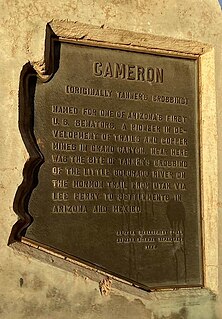
Cameron is a census-designated place (CDP) in Coconino County, Arizona, United States. The population was 885 at the 2010 census. Most of the town's economy is tourist food and craft stalls, restaurants, and other services for north–south traffic from Flagstaff and Page. There is a ranger station supplying information and hiking permits for the Navajo Nation as well as a small selection of books for sale. There is also a large craft store run by the Nation itself; most vendors in the area operate from small private stalls. It is named after Ralph H. Cameron, Arizona's first senator.

Kaibeto is a census-designated place (CDP) in Coconino County, Arizona, United States. The population was 1,522 at the 2010 census.

LeuppLOOP is a census-designated place (CDP) in Coconino County, Arizona, on the Navajo Nation, United States. The population was 951 at the 2010 census.

Moenkopi is a census-designated place (CDP) in Coconino County, Arizona, United States, adjacent to the southeast side of Tuba City off U.S. Route 160. The population was 964 at the 2010 census.

Cibecue is a census-designated place (CDP) in Navajo County, Arizona, United States, on the Fort Apache Indian Reservation. The population was 1,713 in the 2010 United States Census.

Greasewood is a census-designated place (CDP) in Navajo County, Arizona, United States. The population was 547 at the 2010 census.

Casas Adobes is an unincorporated community and census-designated place (CDP) located in the northern metropolitan area of Tucson, Arizona. The population was 66,795 at the 2010 census. Casas Adobes is situated south and southwest of the town of Oro Valley, and west of the community of Catalina Foothills.

Flowing Wells is a census-designated place (CDP) in Pima County, Arizona, United States. It is a suburb of Tucson. The population was 16,419 at the 2010 census.
Sells is a census-designated place (CDP) in Pima County, Arizona, United States. The population was 2,799 at the 2000 census. It is the capital of the Tohono O'odham Nation and the home of several of their tribal businesses, such as Tohono O'Odham Ki:Ki Association. Originally named Indian Oasis, by cattle-ranchers/businessmen brothers, Joseph and Louis Ménager in 1912. The Ménager brothers also built and ran the Indian Oasis Mercantile Store. The settlement took its present English name in 1918 to honor Indian Commissioner Cato Sells. The O'odham name means "Tortoise Got Wedged".

Arizona City is a census-designated place (CDP) in southwestern Pinal County, Arizona, United States. It is located near the junction of Interstate 8 and Interstate 10 at the midpoint between Phoenix and Tucson, approximately 60 miles (97 km) from the downtown of both cities. The population was 10,475 as of the 2010 U.S. Census. It is estimated to be approximately 11,030 as of a 2017 U.S. Census estimate. Arizona City is a rural, primarily residential community that features a 48-acre man-made lake. These attributes make the community a popular snowbird destination, with the population increasing by as much as 5,000 people in the winter months to reach the census figure of 11,030.

Blackwater is a native village and census-designated place (CDP) on the Gila River Reservation in Pinal County, Arizona, United States. The population was 1,062 at the 2010 census, up from 504 in 2000.

Topawa is a census-designated place and unincorporated community in Pima County, Arizona, United States. The population was 315 as of the 2020 census. Topawa is located on the Tohono O'odham Nation reservation, 7.5 miles (12.1 km) south-southeast of Sells. Topawa has a post office with ZIP code 85639.
Red Mesa Unified School District #27 is a public school district headquartered in Red Mesa, unincorporated Apache County, Arizona, near Teec Nos Pos on the Navajo Nation. It has a five-member elected school board, who oversee operations of schools that are regulated by state standards.

Flagstaff High School (FHS) is a secondary school in Flagstaff, Arizona. Flagstaff High School has been opened to the public since 1923. FHS is a four-year public high school of approximately 1,500 students. The students are primarily of five ethnic groups: White, Native American, Hispanic, Asian, and African-American. Approximately 50 percent of the students are minorities; 147 are from various Native American tribes and live at the Bureau of Indian Affairs KinLani Dormitory. The student body represents a broad socio-economic range from low income to upper middle class. Each year approximately 50 percent of the graduates enroll in four-year colleges and universities and 25 percent in two-year institutions.

Tolani Lake is a census-designated place in the eastern portion of Coconino County, Arizona, United States, near the Navajo County border. Tolani Lake is located north of Winslow. The population as of the 2010 U.S. Census was 280.
