
Harda is a town and a municipality in Harda district in the Indian state of Madhya Pradesh. Harda is the administrative headquarters of Harda. Betul city is 125 km far from main city.

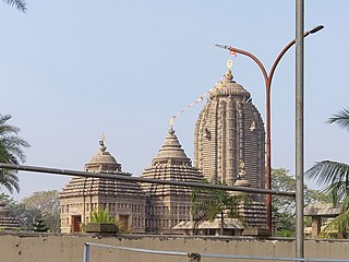
Baripada is a city and a municipality in Mayurbhanj district in the state of Odisha, India. Located along the east bank of the Budhabalanga river, Baripada is the cultural centre of north Odisha. In recent years, it has emerged as an educational hub with the opening of numerous professional colleges.

Mayurbhanj district is one of the 30 districts in Odisha state in eastern India. It is the largest district of Odisha by area. Its headquarters are at Baripada. Other major towns are Rairangpur, Karanjia and Udala. As of 2011, it is the third-most-populous district of Odisha, after Ganjam and Cuttack.
Balasore or Baleswara is a village in the state of Odisha, about 194 kilometres (121 mi) north of the state capital Bhubaneswar and 300 kilometres (186 mi) from Kolkata, in eastern India. It is the largest city of northern Odisha and the administrative headquarters of Balasore district. It is best known for Chandipur beach. The Indian Ballistic Missile Defense Program's Integrated Test Range is located 18 km south of Balasore.

Cuttack district is one of the 30 districts of Odisha state in India. It is located in the coastal part of the state and its administrative headquarters are located in the city of Cuttack. As of 2011 Census, after Ganjam, it is the second most populous district of Odisha, with a population of 2,624,470. The name is an anglicized form of Kataka or Katak meaning Fort – referring to the Barabati Fort. The district is bisected by the river Mahanadi and its numerous distributaries and occupies a large portion of the river's delta. It is bounded by the Angul, Dhenkanal, Nayagarh and Khurda districts to the west while its southern and eastern boundaries touch Puri, Jagatsinghpur, Kendrapara and Jajpur districts.
Udala is a town of India in the state Odisha. It is a Notified Area Committee of district Mayurbhanj under Kaptipada sub-division.

Morigaon is a town of town area committee and the district headquarters of Morigaon district in the Indian state of Assam and including the headquarters of the Tiwa Autonomous Council (TAC), Tiwashong, Assam which was constituted by the Government of Assam on 14 April 1995, The Apex council will consist of 144 villages of Nagaon, Morigaon and Kamrup with 28 blocks. Pincode of Morigaon town is 782105.

Balasore District also known as Baleswar District or Baleshwar District, is an administrative district of Odisha state, in eastern India. Balasore is one of the coastal districts of Odisha and lies on the northernmost part of the state.
Bhadrak is a city of Odisha state in eastern India. It came into existence on 1 April 1993. The city is the district headquarters of Bhadrak district. According to legend, the city derives its name from the Goddess Bhadrakali, whose temple is on the banks of the Salandi River.
Chhatrapur is a town and a Notified Area Council in Ganjam district in the state of Odisha, India. It is the district headquarters town of Ganjam district. Chhatrapur is a Tehsil / Block (CD) in the Ganjam District of Odisha. According to Census 2011 information the sub-district code of Chhatrapur block is 03085. Total area of Chhatrapur is 124 km2 (48 sq mi) including 119.92 km2 (46.30 sq mi) rural area and 4.40 km2 (1.70 sq mi) urban area. Chhatrapur has a population of 94,683 people. There are 20,415 houses in the sub-district. There are about 46 villages in Chhatrapur block.

Baharagora is a village in the Baharagora CD block in the Ghatshila subdivision of the East Singhbhum district, in the Indian state of Jharkhand.
Jaleswar is a town located in the Balasore district of Odisha, in India. It consists of 144 villages, with four major areas: Bada Bazar, Nua Bazar, Station Bazar, and Purana Bazar. Jaleswar is considered one of the new municipalities in the state, and Jaleswar forms a state assembly constituency along with Balipal Block.
Ramban is a town in Ramban district of Jammu and Kashmir, India, which is the district headquarters of Ramban district. It lies on the banks of the Chenab river in Chenab Valley on the National Highway-1A at about 150 km from Jammu and about 150 km from Srinagar, making it almost the central point on the Jammu-Srinagar National Highway.

Hasanchak (Barh), is a village in Barh, Patna District, Bihar, India. The Ganga River flows close to the village.
Ampani is a town in the Kalahandi district of the state of Odisha, in India. It is a gram panchayat that comes under Kokasara tehsil. It is 15 km from its main town and blocks Kokasara.
Soro is a town and a municipality in Balasore district in the Indian state of Odisha. It is about 181 km from the capital of the state Bhubaneswar and 35 km from the district headquarters Balasore. Located on NH-16, the city is located midway between Balasore and Bhadrak cities. Soro along with neighboring cities contributes significantly towards the economy of Balasore district.
Badagam is a small village in the Rayagada Block and Parlakhemundi municipality in Gajapati district in the Indian state of Odisha. The major languages spoken in this place are Kui and Oriya.
Bali is a village in the Indian state of Uttar Pradesh. It is located in the Baghpat block of the Baghpat district.
Jhargram is a district in the state of West Bengal, India.The district lies between the Kangsabati River in the north and the Subarnarekha in the south. Jhargram has one of the lowest population densities among the districts of West Bengal, with almost all its population living in rural areas. It is a popular tourist destination known for its sal forests, elephants, ancient temples and royal palaces. The district was formed on 4 April 2017, after bifurcation from the Paschim Medinipur district as the 22nd district of West Bengal. The district has its headquarters at Jhargram.

Noklak District is the 12th district of the Indian state of Nagaland. It was established on January 20, 2021. The district headquarter is located in the town of Noklak.
