
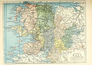
County Mayo is a county in Ireland. In the West of Ireland, in the province of Connacht, it is named after the village of Mayo, now generally known as Mayo Abbey. Mayo County Council is the local authority. The population was 137,231 at the 2022 census. The boundaries of the county, which was formed in 1585, reflect the Mac William Íochtar lordship at that time.

Belmullet is a coastal Gaeltacht town with a population of 1,019 on the Mullet Peninsula in the barony of Erris, County Mayo, Ireland. It is the commercial and cultural heart of the barony of Erris, which has a population of almost 10,000. According to the 2016 census 50% of people in the town were able to speak Irish while only 4% spoke it on a daily basis outside the education system.

Ballaghaderreen is a town in County Roscommon, Ireland. It was part of County Mayo prior to 1898. It is located just off the N5 National primary road. The population was 1,808 in the 2016 census.

Killala is a village in County Mayo in Ireland, north of Ballina. The railway line from Dublin to Ballina once extended to Killala. To the west of Killala is the townland of Townsplots West, which contains a number of ancient forts. Historically associated with Saint Patrick, and the seat of an episcopal see for several centuries, evidence of Killala's ecclesiastical past include a 12th-century round tower and the 17th century Cathedral Church of St Patrick. As of the 2016 census of Ireland, the village had a population of 562.

An Clochán Liath, known in English as Dungloe, is a town in County Donegal, Ireland. It is the main town in The Rosses and the largest in the Donegal Gaeltacht. Dungloe developed as a town in the middle of the 18th century, and now serves as the administrative and retail centre for the west of County Donegal, and in particular The Rosses, with the only mainland secondary school for the area.

The Western Way is a long-distance trail in Ireland. It is 179 kilometres long and begins in Oughterard, County Galway and ends in Ballycastle, County Mayo. It is typically completed in seven days. It is designated as a National Waymarked Trail by the National Trails Office of the Irish Sports Council and is managed by Coillte, Galway County Council, Mayo County Council, South Mayo Development Company and Mayo North & East Development Company.
Bangor Erris is a town in Kiltane parish in Erris, County Mayo, Ireland with a population of over 300. It is on the banks of the Owenmore River and is a "gateway" to the Erris Peninsula linking Belmullet with Ballina and Westport. It is located at the foot of the "Bangor Trail" a 22-mile mountain pass across the Nephin Beg Mountain Range to Newport. Approximately 2 km away is Carrowmore Lake, Bangor is a centre for wild atlantic salmon and sea trout fishing. Bangor Erris is located in the Parish of Kiltane. Due west from Bangor are the towns of Belmullet, Geesala, Mulranny, Westport and Doolough.
Ballyvourney is a Gaeltacht village in southwest County Cork, Ireland. It is a civil parish in the barony of Muskerry West, and is also an ecclesiastical parish in the Roman Catholic Diocese of Cloyne. Ballyvourney is part of the Cork North-West Dáil Constituency.

The Mullet Peninsula —also known as the Mullet and sometimes as the Erris Peninsula—is a peninsula in the barony of Erris in County Mayo, Ireland. As of 2016 it has a population of 3963. It consists of a large promontory connected to the mainland at Belmullet, a town of about 1,000 inhabitants, by a narrow isthmus. There are several villages on the Mullet peninsula including Aughleam, Elly, Corclough and Binghamstown. The Peninsula is about 33 km (21 mi) long and ranges from 200 metres (660 ft) to 12 km (7.5 mi) wide. Its northernmost point is Erris Head. The peninsula's doglegged shape forms two bays, Blacksod Bay and Broadhaven Bay.

Baile na hAbhann, anglicised as Ballynahown, is a Gaeltacht village about 31 km (19 mi) west of Galway, Ireland, on the R336 regional road between Indreabhán and Casla. The name means "town of the river". The village is in the townland of Baile na hAbhann Theas.

Ballyjamesduff is a town in County Cavan, Ireland. A former market town, it was the winner of the 1966 and 1967 Irish Tidy Towns Competition.

Gweesalia or Geesala is a small Gaeltacht village situated on the Gweesalia peninsula in the Electoral Division of Rathhill, in the Civil Parish of Kilcommon, in the Barony of Erris in western County Mayo, Ireland.
Newtowncashel is a village located near Lough Ree in County Longford, Ireland. It is within the townland of Cornadowagh. Newtowncashel won the Irish Tidy Towns Competition in 1980.

Ballycanew is a small rural village in Ireland. It is situated in County Wexford, on the R741 regional road 8 km (5.0 mi) south of Gorey. This road is locally known as the "Coast Road".

Kilsheelan is a village and civil parish within the in the barony of Iffa and Offa East in County Tipperary, Ireland. It is also one half of the Roman Catholic parish of Kilsheelan & Kilcash in the Roman Catholic Diocese of Waterford and Lismore.

Old Parish is a village in west County Waterford, Ireland. It is part of the Gaeltacht in Waterford Gaeltacht na nDéise.
Tirawley, archaically known as Tyrawley, is a barony extending southward from the north coast of County Mayo, Ireland. It was created during the shiring of County Mayo out of the Gaelic túath or territory of Tír Amhlaidh, from which it takes its name.

The R314 road is a regional road in County Mayo in Ireland. It connects the R313 road at Atticonaun to the N59 road in Ballina, 69.9 kilometres (43.4 mi) away.

Ballina is a town in north County Mayo, Ireland. It lies at the mouth of the River Moy near Killala Bay, in the Moy valley and Parish of Kilmoremoy, with the Ox Mountains to the east and the Nephin Beg mountains to the west. The town occupies two baronies; Tirawley on the west bank of the Moy River, and Tireragh, a barony within County Sligo, on its east banks. At the 2016 census, the population of Ballina was 10,171.


