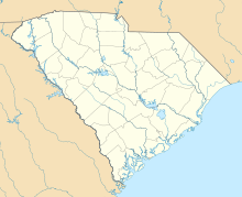
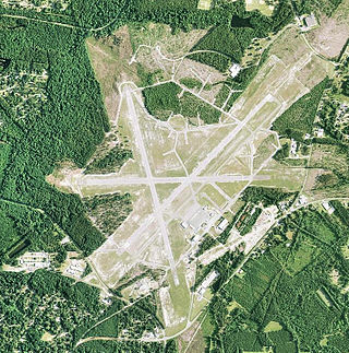
Greenville Downtown Airport is an airport three miles east of Greenville, South Carolina, United States. It is owned by the Greenville Airport Commission and is the busiest general aviation airport in South Carolina.

Ephrata Municipal Airport is a public use airport located 4 km (2.5 mi) southeast of the central business district of Ephrata, a city in Grant County, Washington, United States. It is included in the National Plan of Integrated Airport Systems for 2011–2015, which categorized it as a general aviation airport.
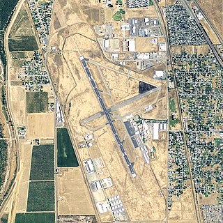
Yuba County Airport is in Yuba County, California, United States, three miles southeast of Marysville. The National Plan of Integrated Airport Systems for 2011–2015 categorized it as a general aviation facility.

Strother Field is a public airport in Cowley County, Kansas, six miles southwest of Winfield and north of Arkansas City. The airport is jointly owned by the two cities. The National Plan of Integrated Airport Systems for 2011–2015 categorized it as a general aviation facility.

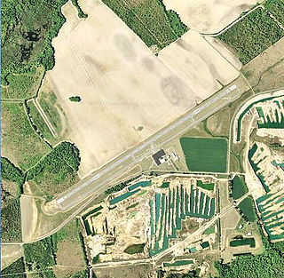
Cross City Airport is a county-owned, public-use airport located one nautical mile (2 km) east of the central business district of Cross City, a city in Dixie County, Florida, United States. It is included in the National Plan of Integrated Airport Systems for 2011–2015, which categorized it as a general aviation facility.

Immokalee Regional Airport is a public use airport located one nautical mile (2 km) northeast of the central business district of Immokalee, in Collier County, Florida, United States. The airport is owned by the Collier County Airport Authority. Formerly known as Immokalee Airport, it is included in the National Plan of Integrated Airport Systems for 2011–2015, which categorized it as a general aviation facility.

Troy Municipal Airport is a city-owned public-use airport located four nautical miles northwest of the central business district of Troy, a city in Pike County, Alabama, United States. It is included in the FAA's National Plan of Integrated Airport Systems for 2011–2015, which categorized it as a general aviation facility.

Stuttgart Municipal Airport is in Prairie County, Arkansas. It is eight miles north of Stuttgart, which owns the airport and is the county seat of Arkansas County's northern district. The FAA's National Plan of Integrated Airport Systems for 2009–2013 categorized it as a general aviation facility.
Marlboro County Jetport, also known as H.E. Avent Field, is a county-owned public-use airport located 3 nautical miles west of the central business district of Bennettsville, in Marlboro County, South Carolina, United States.
Woodward Field is a county-owned public-use airport located 3 nautical miles northeast of the central business district of Camden, a city in Kershaw County, South Carolina, United States. It is also known as the Kershaw County Airport. The airport serves the general aviation community, with no scheduled commercial airline service.
Lowcountry Regional Airport is a public use airport located two nautical miles (4 km) northeast of the central business district of Walterboro, a city in Colleton County, South Carolina, United States. It is owned by the city and county. This airport is included in the National Plan of Integrated Airport Systems for 2011–2015, which categorized it as a general aviation facility. It does not have scheduled commercial airline service.

Orangeburg Municipal Airport is a city-owned, public-use airport located two nautical miles (4 km) south of the central business district of Orangeburg, a city in Orangeburg County, South Carolina, United States. It is included in the National Plan of Integrated Airport Systems for 2011–2015, which categorized it as a general aviation facility. The airport does not have scheduled commercial airline service.

Greenwood County Airport is a county-owned, public-use airport located three nautical miles (6 km) north of the central business district of Greenwood, a city in Greenwood County, South Carolina, United States. It is included in the National Plan of Integrated Airport Systems for 2011–2015, which categorized it as a general aviation facility. The airport does not have scheduled commercial airline service.

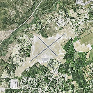
Darlington County Airport (Jetport) is a county-owned, public-use airport located nine nautical miles north of the central business district of Darlington, a city in Darlington County, South Carolina, United States. It is included in the National Plan of Integrated Airport Systems for 2011–2015, which categorized it as a general aviation facility. The airport does not have scheduled commercial airline service.

Charleston Executive Airport is in Charleston in Charleston County, South Carolina, seven miles southwest of the city. It is owned by the Charleston County Aviation Authority. The airport serves the general aviation community, with no airline service.

Georgetown County Airport is a county-owned, public-use airport located three nautical miles (6 km) south of the central business district of Georgetown, a city in Georgetown County, South Carolina, United States. It is included in the National Plan of Integrated Airport Systems for 2011–2015, which categorized it as a general aviation facility. The airport does not have scheduled commercial airline service.

Grand Strand Airport is a county-owned, public-use airport located one nautical mile (1.85 km) northwest of the central business district of North Myrtle Beach, in Horry County, South Carolina, United States. The name Grand Strand refers to a nearby 60-mile stretch of beach; its code CRE refers to nearby Crescent Beach.
Mitchell Municipal Airport is three miles north of Mitchell, in Davison County, South Dakota. The National Plan of Integrated Airport Systems for 2011–2015 categorized it as a general aviation airport.

Wilbarger County Airport is a county-owned, public-use airport in Wilbarger County, Texas, United States. It is located four nautical miles north of the central business district of Vernon, Texas. This airport is included in the National Plan of Integrated Airport Systems for 2011–2015, which categorized it as a general aviation facility.

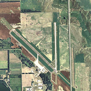
C. David Campbell Field is six miles southeast of downtown Corsicana, in Navarro County, Texas It provides general aviation service.