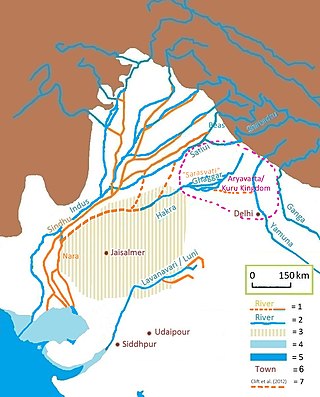
The Sarasvati River is a deified mythological river first mentioned in the Rigveda and later in Vedic and post-Vedic texts. It played an important role in the Vedic religion, appearing in all but the fourth book of the Rigveda.

The Indus Valley Civilisation (IVC), also known as the Indus Civilisation, was a Bronze Age civilisation in the northwestern regions of South Asia, lasting from 3300 BCE to 1300 BCE, and in its mature form 2600 BCE to 1900 BCE. Together with ancient Egypt and Mesopotamia, it was one of three early civilisations of the Near East and South Asia, and of the three, the most widespread, its sites spanning an area from much of Pakistan, to northeast Afghanistan, and northwestern India. The civilisation flourished both in the alluvial plain of the Indus River, which flows through the length of Pakistan, and along a system of perennial monsoon-fed rivers that once coursed in the vicinity of the Ghaggar-Hakra, a seasonal river in northwest India and eastern Pakistan.

Hanumangarh is a city and municipal council in the Indian state of Rajasthan, situated on the banks of the river Ghaggar also identified as ancient Sarasvati river, located about 400 km from Delhi. It is the administrative headquarter of Hanumangarh District. The city was once called Bhatner because it was founded by king Bhupat in 255 AD. It remained in the control of the Rajputs of Bhati clan and faced a historic siege by Timur in 1391, during which the Bhati Raput king Dulachand lost the fort for a short time. The fort was later occupied by Rao Jetsa of Bikaner.

The Ochre Coloured Pottery culture (OCP) is a Bronze Age culture of the Indo-Gangetic Plain "generally dated 2000–1500 BCE," extending from eastern Punjab to northeastern Rajasthan and western Uttar Pradesh.
The Ghaggar-Hakra River is an intermittent river in India and Pakistan that flows only during the monsoon season. The river is known as Ghaggar before the Ottu barrage at 29.4875°N 74.8925°E, and as Hakra downstream of the barrage in the Thar Desert. In pre-Harappan times the Ghaggar was a tributary of the Sutlej. It is still connected to this paleochannel of the Sutlej, and possibly the Yamuna, which ended in the Nara River, presently a delta channel of the Indus River joining the sea via Sir Creek.

Kalibangān is a town located at 29.47°N 74.13°E on the left or southern banks of the Ghaggar in Tehsil Pilibangān, between Suratgarh and Hanumangarh in Hanumangarh District, Rajasthan, India 205 km. from Bikaner. It is also identified as being established in the triangle of land at the confluence of Drishadvati and Sarasvati Rivers. The prehistoric and pre-Mauryan character of Indus Valley civilization was first identified by Luigi Tessitori at this site. Kalibangan's excavation report was published in its entirety in 2003 by the Archaeological Survey of India, 34 years after the completion of excavations. The report concluded that Kalibangan was a major provincial capital of the Indus Valley Civilization. Kalibangan is distinguished by its unique fire altars and "world's earliest attested ploughed field". It is around 2900 BC that the region of Kalibangan developed into what can be considered a planned city.

The ancient site at Kot Diji was the forerunner of the Indus Civilization. The occupation of this site is attested already at 3300 BCE. The remains consist of two parts; the citadel area on high ground ), and outer area. The Pakistan Department of Archaeology excavated at Kot Diji in 1955 and 1957.
Rehman Dheri or sometime Rahman Dheri is a Pre-Harappan Archaeological Site situated near Dera Ismail Khan in the Khyber Pakhtunkhwa province of Pakistan. This is one of the oldest urbanised centres found to date in South Asia. Dated, the site is situated 22 kilometres (14 mi) north of Dera Ismail Khan. It is on the Tentative List for future World Heritage Sites in Pakistan.

Pottery in the Indian subcontinent has an ancient history and is one of the most tangible and iconic elements of Indian art. Evidence of pottery has been found in the early settlements of Lahuradewa and later the Indus Valley Civilisation. Today, it is a cultural art that is still practiced extensively in the subcontinent. Until recent times all Indian pottery has been earthenware, including terracotta.
Banawali is an archaeological site belonging to Indus Valley civilization period in Fatehabad district, Haryana, India and is located about 120 km northeast of Kalibangan and 16 km from Fatehabad. Banawali, which is earlier called Vanavali, is on the left banks of dried up Sarasvati River. Comparing to Kalibangan, which was a town established in lower middle valley of dried up Sarasvathi River, Banawali was built over upper middle valley of Sarasvati River.

Bhirrana, also Bhirdana and Birhana, is an archaeological site, located in a small village in the Fatehabad district of the north Indian state of Haryana. Bhirrana's earliest archaeological layers predates the Indus Valley civilisation times, dating to the 8th-7th millennium BCE. The site is one of the many sites seen along the channels of the seasonal Ghaggar river, thought by some to be the Rigvedic Saraswati river.
Bhagwanpura, also known as Baghpur, is a village in Kurukshetra district, Haryana, India. It is an archaeological site that lies on the bank of Hakra Ghaggar channel. Situated 24 km northeast of Kurukshetra, the site is notable for showing an overlap between the late Harappan and Painted Grey Ware cultures. Painted Grey Ware is generally associated with the Vedic people, so this area can be said as the junction of two great civilizations of India.
Kunal is a pre-Harappan Indus Valley civilisation settlement located, just 30 km from Fatehabad City in Fatehabad district of Haryana state in India. Compared to other IVC sites, such as cities like Rakhigarhi and towns like Kalibangan, Kunal site was a village. Excavation at Kunal show 3 successive phases of Pre-Harappan indigenous culture on the Saraswati river who also traded with Kalibanga and Lothal. Kunal, along with its other contemporary sites Bhirrana and Rakhigarhi on Sarasvati-Ghaggar river system, is recognised as the oldest Pre-Harappan settlement, with Kunal being an older cultural ancestor to Rehman Dheri in Pakistan< which is on the Tentative List for future World Heritage Sites.
Rang Mahal is a village and an ancient Kushan era archaeological site on Suratgarh-Hanumangarh road in Suratgarh tehsil of Sri Ganganagar district in the Indian state of Rajasthan. It can be reached from Hanumangarh, Pilibangan, Suratgarh. Suratgarh is the nearest major railway station to Rang mahal village.
Karanpura is an archeological site near Bhadra city of Hanumangarh district in Rajasthan, India. It belongs with ancient Indus Valley civilization. Harappan pottery has been found after excavation.
Binjor - 4MSR is an archaeological site in India, near the international border between Punjab and Rajasthan. It is situated a couple of kilometers from Binjor village, Anupgarh tehsil, Sri Ganganagar district.
The Indori river, is a rain-fed river originates from Aravalli Range from Sikar district and flows through Alwar district of Rajasthan to Rewari district of Haryana and it is the longest tributary of Sahibi River which stretches to 50 km. In Delhi, it is called the Najafgarh drain or Najafgarh Nallah.
The Krishnavati river, also called Kasaunti, is a rain-fed river originates from Aravalli Range near Dariba copper mines in Rajsamand district of Rajasthan, and flows through Patan in Dausa district and Mothooka in Alwar district and then disappears in Mahendragarh district in Haryana where it used to be a tributary of Sahibi River, which in turn still is a tributary of Yamuna. Several Ochre Coloured Pottery culture sites have been found along the banks of Krishnavati, Sahibi river, Dohan river and Sota River. The drainage pattern for all these rivers is dendritic.
The Dohan river, is a rain-fed river that originates at Mandholi village near Neem Ka Thana in Sikar district of Rajasthan and then disappears in Mahendragarh district in Haryana where it used to be a tributary of Sahibi River, which in turn is a still flowing tributary of Yamuna. Its canalised portion in one of its paleochannel in Haryana is called the "Outfall Drain No 8".

Hakra Ware culture was a material culture which is contemporaneous with the early Harappan Ravi phase culture of the Indus Valley in Northern India and eastern-Pakistan. This culture arises in the 4th millennium with the first remnants of Hakra Ware pottery appearing near Jalilpur on the Ravi River about 80 miles (130 km) southwest of Harappa in 1972. Along with this, numerous other areas including Kunal, Dholavira, Bhirrana, Girwas, Farmana and Rakhigarhi areas of India contained Hakra Ware pottery.


