Batiscan, Quebec

Last updated

Batiscan
Batiscan 0014.jpg
Principale Street, Chemin du Roy, Road 138
Motto: 
"Do Well What You Do"
Batiscan Quebec location diagram.png
Location within Les Chenaux RCM.
Canada Central Quebec location map.png
Red pog.svg
Batiscan
Location in central Quebec.
Coordinates: 46°30′N72°15′W / 46.500°N 72.250°W / 46.500; -72.250 [1]
CountryFlag of Canada (Pantone).svg  Canada
Province Flag of Quebec.svg  Quebec
Region Mauricie
RCM Les Chenaux
Settled1666
ConstitutedJuly 1, 1855
Government
[2]
  MayorChristian Fortin
   Federal riding Saint-Maurice—Champlain
   Prov. riding Champlain
Area
  Total58.90 km2 (22.74 sq mi)
  Land42.95 km2 (16.58 sq mi)
Population
 (2011) [3]
  Total940
  Density21.9/km2 (57/sq mi)
  Pop 2006-2011
Decrease2.svg 0.9%
  Dwellings
510
Time zone UTC−5 (EST)
  Summer (DST) UTC−4 (EDT)
Postal code(s)
Area codes 418 and 581
Highways
Quebec Autoroute 40.svg A-40

Qc138.svg R-138
Qc361.svg R-361
GNBC CodeELIDL
NTS Map031I08
Website www.batiscan.ca

Batiscan is a municipality in the Mauricie region of the province of Quebec in Canada. It is located along the St Lawrence River at the mouth of the Batiscan River.

Contents

The usage includes Batiscan in Batiscanie, the common name for the region. [4]

Geography

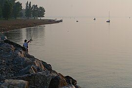
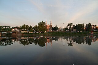
The community of Batiscan is located on the north shore of the St. Lawrence River. Part of its territory drains directly into the St. Lawrence River. The territory of the Lordship of Batiscan is part of the major units of relief that structure the Quebec space.

To the interior lies the fairly flat plain of the St. Lawrence Lowlands. This plain was covered by glacial sediments during the Last Glacial Period (Pleistocene) and by marine and fluvial deposits (clay/sand) with the invasion of the Champlain Sea. This flat landform unit was used for the first settlements in Batiscanie. Up to the foothills of the Laurentians, the place offers: proximity to the rivers, smooth terrain and fertile soils.

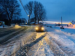
The Batiscan territory is linked to "the continental climate with cold winters" where a long, harsh and snowy winter dominates. From November to April, snow covers the ground and the waterways are frozen. In 1661, Pierre Boucher (1622-1717), French explorer and Governor of New France, wrote to King Louis XIV of France: The severity of winter forced the pioner on the shores of the St. Lawrence, "to hide in his home (chaumière)". [4]

History

In 1609, Samuel de Champlain, on his way to Lake Champlain, wrote of a Huron and Algonquin encampment one and a half leagues from St. Mary's River, which places it around the modern settlement of Batiscan. A year later, he wrote of having met an indigenous leader called "Batiscan". On his map of 1612, Champlain designated this area north of the Saint Lawrence River as the "region of bastisquan". While the name has virtually remained unchanged since first mentioned by Champlain, its meaning has remained uncertain, possibly meaning mist or haze (as often seen at the mouth of the Batiscan River), pulverized dried meat, rushes, or even making a mistake, taking a misstep. [1]

In 1636, the Madeleine Seignory was granted to Jacques Laferté, and included all the territory between the Chevrotière and Saint-Maurice Rivers, until 100 kilometers inland from the Saint Lawrence River. Subsequently, the seignory was divided into several smaller estates or fiefs, including the Batiscan Fiefdom that on March 13, 1639, was given to the Jesuits to accommodate the evangelization and the settlement of Indian tribes living there. This territory corresponded approximately to the current municipalities of Batiscan and Saint-Geneviève-de-Batiscan. [5]

The actual colonization of the area began in 1666, and it developed according to the seigneurial system of New France. The land granted to each settler was typically a long narrow rectangle with a proportion of about 1 to 10, that would allow each settler access to the river and the road. By 1709, all land bordering the Saint Lawrence River was occupied and a second row was equally divided inland. Over time, the territory of Batiscan grew to have 3 rows south-west of the Batiscan River and 2 rows north-east of it. [5]

Settlers would cultivate a portion of their land, but because of outdated farming techniques, isolation from markets, and lack of roads, agriculture remained a challenge. But with the Batiscan River providing access to the interior and the trading post at Trois-Rivières providing market access, people from Batiscan turned to trapping for survival. Logging also provided opportunities and several sawmills appeared along the rivers flowing through the area. [5]

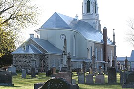
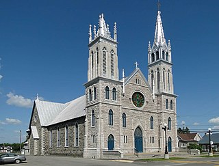
On November 2, 1684, the Parish of Saint-François-Xavier-de-Batiscan was formed, named by the Jesuits after one of the co-founders of their order, Francis Xavier. The community itself developed as a linear village, stretching along the Chemin du Roy and without any real village centre, exceeding even the administrative boundaries of cadastral parishes. By the end of the French Era, the towns of Champlain, Batiscan, and Sainte-Anne-de-la-Pérade were all connected by a long ribbon of buildings. [5]

After 1712, Batiscan was one of the places in which French settlers enslaved Fox Indians of Wisconsin. [6]

In 1845, the Parish Municipality of Saint-François-Xavier-de-Batiscan was formed. It was abolished a few years later but reestablished on July 1, 1855. [1]

The industrial revolution led to economic development and a small port on the river and the railroad were built. At the Batiscan station, a new small village centre grew. But the economic crisis of 1929 broke the momentum of the Station Village and gradually agriculture reclaimed primary place in the landscape and economy of Batiscan, with commercial and industrial activities remaining marginal. [5]

Because of its proximity to the regional hub of Trois-Rivières, the growing use of cars, and the improved road network, Batiscan is becoming a suburban community, leading to increased urbanization of the Saint Lawrence shore. [5]

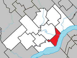
In 1986, the Parish Municipality of Saint-François-Xavier-de-Batiscan became the Municipality of Batiscan. On December 31, 2001, it was transferred from the Francheville Regional County to the new Les Chenaux Regional County, following the creation of the new City of Trois-Rivières and the dissolution of the Francheville RCM. [1]

The Geographical Evolution of Colonization. Because of its early and intensive development, Batiscan was already the largest Lordship in the Trois-Rivières area by the end of the seventeenth century. The shores of the St. Lawrence River were already occupied, pioneers were moving inland along the Batiscan River. [7]

Demographics

Population trend: [8]

Private dwellings occupied by usual residents: 443 (total dwellings: 510)

Mother tongue:

Photos

St Lawrence River

Flore

Built heritage

Chemin du Roy

See also

Related Research Articles

<span class="mw-page-title-main">Deschambault-Grondines</span> Municipality in Quebec, Canada

Deschambault-Grondines is a municipality located in the Portneuf Regional County Municipality (RCM), in the Capitale-Nationale region, Quebec, Canada.

<span class="mw-page-title-main">Mékinac Regional County Municipality</span> Regional county municipality in Quebec, Canada


Mékinac is a regional county municipality (RCM) of 5,607 km2 located in the administrative region of Mauricie, along the Saint-Maurice River, which also crosses the RCM from one end to the other, and the Matawin River, a tributary of the Saint-Maurice. Located in the province of Quebec, Canada.

<span class="mw-page-title-main">Les Chenaux Regional County Municipality</span> Regional county municipality in Quebec, Canada

Les Chenaux is a regional county municipality in central Quebec, Canada, in the Mauricie region. The seat is in Saint-Luc-de-Vincennes. It is located adjacent on the east of Trois-Rivières on the Saint Lawrence River. It has a land area of 872.04 square kilometres (336.70 sq mi) and a population of 17,865 inhabitants in the Canada 2011 Census. Its largest community is the parish of Notre-Dame-du-Mont-Carmel.

<span class="mw-page-title-main">Saint-Séverin, Mauricie, Quebec</span> Parish municipality in Quebec, Canada

Saint-Séverin is a parish municipality in Quebec (Canada) in the Mékinac Regional County Municipality, Quebec, in the administrative region of Mauricie and watershed the Batiscanie. At various times, the place was also known as Saint-Séverin-de-Proulxville and Proulxville.

<span class="mw-page-title-main">Saint-Adelphe</span> Place in Quebec, Canada

Saint-Adelphe is a parish municipality located in the Mékinac Regional County Municipality (RCM), located in Mauricie, Quebec province, Canada.

<span class="mw-page-title-main">Saint-Prosper-de-Champlain, Quebec</span> Municipality in Quebec, Canada

Saint-Prosper-de-Champlain is a municipality of 516 people in the Les Chenaux Regional County Municipality, in Quebec, Canada. It is the smallest municipality in terms of population in the regional county.

<span class="mw-page-title-main">Saint-Stanislas, Mauricie, Quebec</span> Municipality in Quebec, Canada

Saint-Stanislas, old name Deux-Rivières (Village), is a municipality part of Les Chenaux Regional County Municipality, in Mauricie, Quebec, Canada.

<span class="mw-page-title-main">Saint-Narcisse</span> Parish municipality in Quebec, Canada

Saint-Narcisse is a parish municipality located in the regional county municipality (MRC) Chenaux, in the administrative region of Mauricie, in the province of Quebec, in Canada. Located on the North Shore of the Saint Lawrence River, about 30 km (19 mi) from downtown Trois-Rivières, the parish of Saint-Narcisse is the heart of the Mauricie region.

<span class="mw-page-title-main">Sainte-Geneviève-de-Batiscan</span> Parish municipality in Quebec, Canada

Sainte-Geneviève-de-Batiscan is a parish municipality in the Mauricie region of the province of Quebec in Canada. This municipality is part of the Les Chenaux Regional County Municipality in Batiscanie and in the administrative region of Mauricie. It is located along the Batiscan River.

<span class="mw-page-title-main">Champlain, Quebec</span> Municipality in Quebec, Canada

Champlain is a municipality in the province of Quebec, Canada. It is located in Les Chenaux Regional County Municipality and the administrative region the Mauricie, on the north shore of St. Lawrence River. Champlain is also part of the metropolitan area of Trois-Rivières.

<span class="mw-page-title-main">Notre-Dame-de-Montauban</span> Municipality in Quebec, Canada

Notre-Dame-de-Montauban is a municipality in the Mauricie region in Quebec, Canada. The municipality is on the northern edge of Mékinac Regional County Municipality and the administrative region of Mauricie and includes the population centres of Notre-Dame-des-Anges and Montauban-les-Mines. Both communities are located along route 367 and are about 7 kilometres (4.3 mi) apart.

<span class="mw-page-title-main">Batiscan River</span> River in Quebec, Canada

Batiscan River has its source in the region of Lac Édouard, in the Laurentians Mountains, the Batiscan River flows over a length of 177 km. It receives water from numerous tributaries, including, in its upper reach, the Rivière aux Éclairs and the Jeannotte river. In its downstream part, it waters Saint-Narcisse and Sainte-Geneviève-de-Batiscan before flowing into the St. Lawrence River at Batiscan.

<span class="mw-page-title-main">Batiscanie</span>

Batiscanie, a vernacular name, of a territory located in the Mauricie region, divided between the RCMs of Les Chenaux, Portneuf and Mékinac, in Quebec, Canada.

<span class="mw-page-title-main">Veillet River</span> River in Quebec, Canada

The Veillet River is located in the municipality of Sainte-Geneviève-de-Batiscan, in the Regional County Municipality of "Les Chenaux", in the administrative region of Mauricie, in the province of Quebec, Canada.

<span class="mw-page-title-main">Seigneurie of Batiscan</span> Historical seigneurie in Quebec, Canada

The Seigneurie of Batiscan was located on, and included 1/2 lieue of frontage along, the north shore of the St. Lawrence River in the province of Quebec, Canada. It was 20 lieues deep. Granted in 1639 to the Jesuits, colonization of the manor began in 1666, after an initial allotments were added to the census in 1665.) The northern boundary of the seigneurie was past the source of the Saint-Maurice River. It was the deepest in the seigneurial system of New France. The seigneurie of Batiscan became the most populous governed area of the Three Rivers by the end of the 17th Century.

The Lordship of Champlain was granted in 1664, on the north side of the St. Lawrence River between Trois-Rivières and Quebec City, under the feudal system of New France. Today, the territory of the former manor of Champlain is located in the administrative region of Mauricie in Quebec, Canada. The capital was the town of Champlain.

<span class="mw-page-title-main">Champlain River</span> River in Canada

The Champlain River flow on the north shore of St. Lawrence river, between Saint-Maurice River and the Batiscan River watershed, in Les Chenaux Regional County Municipality, in Mauricie administrative region, in the province of Quebec, Canada.

The Lordship of Sainte-Anne-de-la-Pérade was located on the north shore of St. Lawrence river, between Trois-Rivières and Quebec City in the province of Quebec, Canada. The southern front of the manor was on the edge of St. Lawrence river. The depth of the lordship was heading north, parallel to the Lordship of Batiscan. The northern boundary of the Lordship of Sainte-Anne-de-la-Perade stopped at the north-western boundary of St. Joseph row, in Sainte-Thècle. In comparison, the lordship of Batiscan spanned 20 "lieues", beyond the Saint-Maurice River. The western boundary of the manor cut the Batiscan river at the rapids of Manitou, between Saint-Adelphe and Saint-Stanislas. The estates of the north shore of St. Lawrence river fell within the stately administrative division of Trois-Rivières.

<span class="mw-page-title-main">Rivière des Chutes</span> River in Canada

The Rivière des Chutes drains mainly the municipality of Saint-Narcisse, and also Saint-Stanislas, at the end of its course. These municipalities are located in the Les Chenaux Regional County Municipality, in the administrative region of Mauricie, in the province of Quebec, Canada.

<span class="mw-page-title-main">Rivière-à-la-Lime</span> River

The Rivière à la lime flows in the municipality of Sainte-Geneviève-de-Batiscan, in the Les Chenaux Regional County Municipality, in the administrative region of Mauricie, in the province of Quebec, Canada. The "rivière à la lime" drains a watershed of 25.86 km2. This river has a length of 12.14 km and empties into the Batiscan River.

References

  1. 1 2 3 4 "Batiscan (Municipalité)" (in French). Commission de toponymie du Québec. Retrieved 2010-02-17.
  2. 1 2 "Répertoire des municipalités: Geographic code 37210". www.mamh.gouv.qc.ca (in French). Ministère des Affaires municipales et de l'Habitation.
  3. 1 2 "Batiscan, Quebec (Code 2437210) Census Profile". 2011 census . Government of Canada - Statistics Canada.
  4. 1 2 Jean-Philippe Marchand. "The Colonization of the Lordship of Batiscan in the 17th and 18th Centuries: Space and People" (PDF). Érudit an inter-university consortium (in English and French). Master's thesis, Université du Québec à Chicoutimi. pp. 4, 16 of 162. Retrieved 2023-12-05. The most important stronghold of the government of Trois-Rivières, during the French Regime
  5. 1 2 3 4 5 6 "Histoire de Batiscan" (in French). Municipalité de Batiscan. Retrieved 2010-02-17.
  6. Rushforth, Brett (1 January 2006). "Slavery, the Fox Wars, and the Limits of Alliance". William and Mary Quarterly. 63 (1): 66. doi:10.2307/3491725. JSTOR   3491725 . Retrieved 7 April 2022.
  7. Jarnoux, Phllipe (1986). "La colonisation de la seigneurie de Batiscan aux 17e et 18e siècles : l'espace et les hommes" (PDF) (in English and French). Institut d'histoire de l'Amérique française. p. 30. Retrieved 2023-11-18. This article examines the settlement of the Lordship of Batiscan, the largest fief in the government of Trois-Rivières during the French Regime
  8. Statistics Canada: 1996, 2001, 2006, 2011 census
  9. Corporation touristique de Batiscan, Raymond Rivard président. "Hangar de Batiscan" . Retrieved 13 May 2023.
  10. Site historique. "Vieux presbytère de Batiscan" . Retrieved 13 May 2023.

Historical publications