Lewisboro is a town in Westchester County, New York, United States. The population was 12,411 at the 2010 census. The town is named after John Lewis, an early settler. Lewisboro is a suburb of New York City.

The East Bay Regional Park District (EBRPD) is a special district operating in Alameda County and Contra Costa County, California, within the East Bay area of the San Francisco Bay Area. It maintains and operates a system of regional parks which is the largest urban regional park district in the United States. The administrative office is located in Oakland.
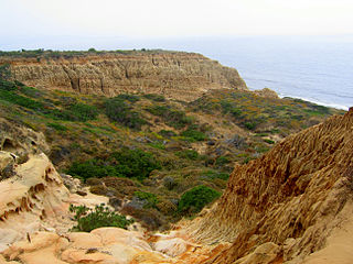
Torrey Pines State Natural Reserve is 2,000 acres (810 ha) of coastal state park located in San Diego, California, off North Torrey Pines Road. Although it is located within San Diego city limits, it remains one of the wildest stretches of land (8 km²) on the Southern California coast. It is bordered immediately on the south by Torrey Pines Municipal Golf Course and on the north by the city of Del Mar. The reserve was designated a National Natural Landmark in 1977.

Forest Park is a public municipal park in the Tualatin Mountains west of downtown Portland, Oregon, United States. Stretching for more than 8 miles (13 km) on hillsides overlooking the Willamette River, it is one of the country's largest urban forest reserves. The park, a major component of a regional system of parks and trails, covers more than 5,100 acres (2,064 ha) of mostly second-growth forest with a few patches of old growth. About 70 miles (110 km) of recreational trails, including the Wildwood Trail segment of the city's 40-Mile Loop system, crisscross the park.
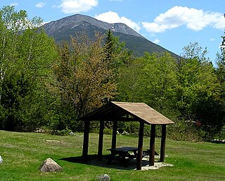
Baxter State Park is a large wilderness area permanently preserved as a state park in Northeast Piscataquis, Piscataquis County in north-central Maine, United States. It is in the North Maine Woods region and borders the Katahdin Woods and Waters National Monument on the east.

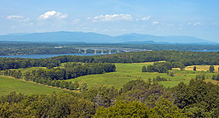
Hudson Highlands State Park is a non-contiguous state park in the U.S. state of New York, located on the east side of the Hudson River. The park runs from Peekskill in Westchester County, through Putnam County, to Beacon in Dutchess County, in the eastern section of the Hudson Highlands.

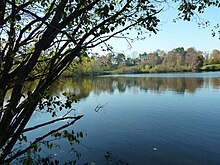
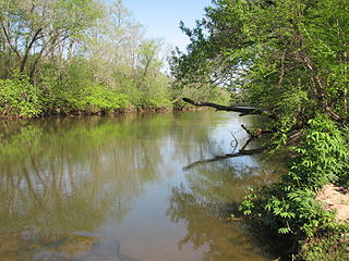
Rockefeller State Park Preserve is a state park in Mount Pleasant, New York in the eastern foothills of the Hudson River in Westchester County. Common activities in the park include horse-riding, walking, jogging, running, bird-watching, and fishing. The park has a rich history and was donated to the State of New York over time by the Rockefeller family beginning in 1983. A section of the park, the Rockwood Hall property, fronts the Hudson River. It was formerly the private residence of William Rockefeller, and began use as a New York state park in the early 1970s. In 2018, the park was added to New York's State Register of Historic Places.

Brown County State Park is located in the United States in the center of the southern half of the state of Indiana. The park is by far the largest of 24 state parks in Indiana, and occupies 15,776 acres (63.84 km2)—making it one of the larger state parks in the United States. It is among Indiana's most visited state parks with about 1.2 million visitors annually. Although Bloomington, Indiana, is the closest city, the park is closer to the small town of Nashville in Brown County. Brown County is named for General Jacob Brown, who fought in the War of 1812 and became Commanding General of the United States Army.

Herrontown Woods Arboretum is an arboretum located on Snowden Lane near the junction with Herrontown Road, in Princeton, New Jersey. It is open to the public every day at no cost. There are walking trails, but trail bicycles are prohibited.

The Columbus and Franklin County Metro Parks are a group of 20 metropolitan parks in and around Columbus, Ohio. They are officially organized into the Columbus and Franklin County Metropolitan Park District. The Metro Parks system was organized in 1945 under Ohio Revised Code Section 1545 as a separate political division of the state of Ohio. The Metro Parks are overseen by a Board of Park Commissioners consisting of three citizens appointed to three-year terms without compensation by the Judge of the Probate Court of Franklin County, Ohio. The Board in turn appoints an Executive Director responsible for operations and management of the parks.

Tohono Chul is a botanical garden, nature preserve, and cultural museum located in Casas Adobes, a suburb of Tucson, Arizona. The words "tohono chul" translate as "desert corner" and are borrowed from the language of the Tohono O’odham, the indigenous people of southern Arizona. The mission of Tohono Chul is to connect people with the nature, art and culture of the Sonoran Desert region and to "inspir[e] wise stewardship of the natural world".

Tumalo State Park is a well-developed state park in Deschutes County, Oregon, United States. Established in 1954, the park is located northwest of the city of Bend and along the Deschutes River at a site home to many bird species. The park is popular for picnics, swimming, fishing, hiking, and camping, and is open year-round.

Chandler State Wayside is a state park in south-central Oregon in the United States. It is named in honor of Solomon and Hattie Chandler, who donated the land for the park. The park covers 85 acres (34 ha) of pine forest along a creek. The park provides restrooms and other basic facilities to accommodate the traveling public. Chandler State Wayside is administered by the Oregon Parks and Recreation Department.

The William H. McGuffey Boyhood Home Site is a National Historic Landmark in Mahoning County, Ohio. It is the location where William H. McGuffey (1800-1873), lived for much of his youth. McGuffey is best known as the creator of the McGuffey Readers, a hugely popular set of educational primers. The site, now a regional park known as the McGuffey Wildlife Preserve, was designated a National Historic Landmark in 1966.
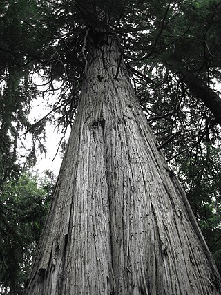
South Whidbey State Park is a public recreation area consisting of 381 acres (154 ha) of old-growth forest and tidelands with 4,500 feet (1,400 m) of shoreline on Admiralty Inlet along the west shore of Whidbey Island in Island County, Washington. The state park contains many mature specimens of western red cedar, Douglas fir, Sitka spruce, and western hemlock, some of the largest on Whidbey island, including a giant cedar over 500 years old.
Mayo River State Park is a North Carolina state park in Rockingham County, North Carolina in the United States. It covers 2,778-acre (11.24 km2) along the Mayo River, and it adjoins a Virginia State Park of the same name. North Carolina's park is near Mayodan, North Carolina. The park is one of the newest in the North Carolina system, having been authorized by the General Assembly in May 2003.

Redmond–Bend Juniper State Scenic Corridor is a collection of ten unimproved land parcels administered for the Oregon Parks and Recreation Department. The parcels are located along U.S. Route 97 between Bend and Redmond, Oregon, United States. It is named for the large western juniper trees found on the parcels. The scenic corridor is completely undeveloped with no trails or park facilities of any kind.

Sisters State Park is a state park located at the southeast side of the town of Sisters in Deschutes County, Oregon, United States. The park property is bisected by U.S. Route 20 and Oregon Route 126, creating three separate parcels. The park covers 28 acres (11 ha) of undeveloped forest land along Whychus Creek. It is adjacent to two developed city parks that were once part of the state park. Sisters State Park is administered by the Oregon Parks and Recreation Department.
Ferncliff Forest is a 200-acre (0.81 km2) old-growth forest preserve of deciduous and hemlock trees located in Rhinebeck, a town in the northern part of Dutchess County, New York, USA. The property had been bought in 1900 by John Jacob Astor IV and remained in the Astor family until 1964, when it was donated as a forest preserve and game refuge.

The Big Sur Land Trust is a private 501(c)(3) non-profit located in Monterey, California, that has played an instrumental role in preserving land in California's Big Sur and Central Coast regions. The trust was the first to conceive of and use the "conservation buyer" method in 1989 by partnering with government and developers to offer tax benefits as an inducement to sell land at below-market rates. Since 1978, with the support of donors, funders and partners, it has conserved over 40,000 acres through conservation easements, acquisition and transfer of land to state, county and city agencies. It has placed conservation easements on 7,000 acres and has retained ownership of over 4,000 acres.