Baxter State Park

Last updated

Baxter State Park
IUCN category V (protected landscape/seascape)
TJWikiBaxterKatahdin.JPG
Katahdin rises above Katahdin Stream Campground in Baxter State Park.
USA Maine relief location map.svg
Red pog.svg
Location in Maine
Location Piscataquis County, Maine, United States
Nearest city Millinocket
Coordinates 46°2′N68°56′W / 46.033°N 68.933°W / 46.033; -68.933 Coordinates: 46°2′N68°56′W / 46.033°N 68.933°W / 46.033; -68.933
Area209,501 acres (847.82 km2)
EstablishedMarch 3, 1931
Visitors67,774(in 2018)
Governing bodyBaxter State Park Authority

Baxter State Park is a large wilderness area permanently preserved as a state park in Northeast Piscataquis, Piscataquis County in north-central Maine, United States. It is in the North Maine Woods region and borders the Katahdin Woods and Waters National Monument on the east.

Contents

The park was established by 28 donations of land, in trust, from park donor Percival P. Baxter between the years of 1931 and 1962, eventually creating a park of over 200,000 acres (809 km2) in size. Baxter Park is not part of the Maine State Park system. Sole governance is provided by the Baxter State Park Authority, consisting of the Maine Attorney General, the Maine Commissioner of Inland Fisheries and Wildlife, and the Director of the Maine Forest Service. The park is independently funded through a combination of revenues from trusts, user fees, and the sale of forest products from the park's Scientific Forest Management Area. The park is home to the state's highest peak, Mount Katahdin. The number of visitors to the park declined from 75,000 in 2000 to 55,000 in 2005, [1] but since 2005 visitor use has been slowly increasing. In 2018, the gate counts were 67,774. [2]

Geography and climate

Katahdin consists of a cluster of mountains. The highest peak, Baxter Peak, is named after park donor and former Maine Governor Percival P. Baxter and rises up to 5,267 feet (1,605 m). The mountain is the northern terminus of the Appalachian Trail. [3]

There are many bodies of water in the park. The three largest bodies of water are Grand Lake Matagamon, Webster Lake, and Nesowadnehunk Lake. There are also several smaller ponds, such as Hudson, Draper, Russell, Center and the South Branch ponds. Numerous streams and rivers connect these water bodies, most prominently Trout Brook (between Grand Lake Matagamon and Nesowadnehunk Lake) and Nesowadnehunk Stream (connecting Nesowadnehunk Lake and the small collection of ponds near Sentinel Mountain). Some of these have waterfalls; Nesowadnehunk Stream has Big and Little Niagara Falls, as well as Ledge Falls. Wassataquoik Stream has two waterfalls, Grand and Norway; another popular waterfall is Green Falls, tucked between Bald Mt. and South Pogy Mt. None of this water is potable, and the park advises that visitors bring or treat their water. [4]

The climate of Baxter State Park lies within the Northern Forest Region of the American continent and experiences the cool, moist climate typical of this region. The annual mean temperature is 38.6 °F (3.7 °C); the record high temperature is 95 °F (35 °C), and the record low stands at −45 °F (−43 °C). The average annual precipitation is 37 inches (940 mm) which includes 100 inches (2,500 mm) per year of snow. Summer temperatures and conditions peak in the park in July and August; fall foliage colors begin to emerge in early September and peak in late September or early October. Leaf-fall in deciduous trees is complete by the end of October. Lasting snowfall usually begins in mid-to-late November, and lasts through April. Leaves emerge on deciduous trees around the last week of May. Weather in Baxter State Park can be characterized primarily by its variability; snowfall can occur any month of the year, and temperatures can and do fluctuate widely around the averages.[ citation needed ]

Wildlife

Baxter State Park has a diverse population of wildlife, the most common of which are the moose, the black bear, and the white-tailed deer. These animals are most active during the summer months and can sometimes be seen from the road. The many marshes and bogs of the park serve as habitats for such animals as beaver, muskrats, river otters, and raccoons. Wooded areas of the park support other types of wildlife, including bobcats, fishers, martens, weasels, chipmunks, red squirrels, snowshoe hares, coyotes, lemmings, and red foxes. There is also an avian population in the park; the most common birds are warblers, thrushes, and flycatchers as well as owls, hawks, eagles, and ducks and other wetland birds.

History

In 1920, eventual Governor Percival P. Baxter participated in an expedition to the top of Mount Katahdin, led by Burton Walter Howe (then-chairman of the Aroostook county Republican party), to determine its feasibility for the site of a national park.

The expedition included not only Baxter, the presumptive choice for President of the Senate, but also Charles P. Barnes, who was widely regarded as the leading candidate for Speaker of the House of Representatives of Maine when it convened in January 1921. The expedition’s guide was Roy Dudley, the long-time game warden at Chimney Pond. [5]

After assuming the Maine Senate presidency during the state's 80th legislative session, Percival Baxter appointed his brother Rupert, a Senator from Sagadahoc County, to the Committee on State Lands and Forest Preservation, which would be considering legislation that would create a state park at Katahdin. Baxter introduced on January 25, 1921 “AN ACT to Establish the Mt. Katahdin State Park” (80th Legislature, Senate No. 19). The unexpected death of Governor Frederick H. Parkhurst on January 31, 1921, triggered Senate President Baxter’s elevation to the governorship. This unforeseen development dramatically changed the political fortunes of Baxter's park proposal. William F. Dawson's illustrated lecture, scheduled by Baxter for February 2, 1921, was canceled, and in its stead legislators were filing past Parkhurst’s coffin laid out in the Capitol’s rotunda. Baxter, the newly inaugurated governor, was no longer able to direct legislative deliberations on his bill. [5]

With failed legislation, Baxter started to use his personal wealth to purchase land and pieced together the park by himself. His first action was a 6,000-acre (24 km2) purchase from the Great Northern Paper Company in 1930. He officially donated that parcel to the State of Maine in 1931 with a condition that the park be kept as wild in perpetuity. Baxter continued more purchases in his 32-year mission. He made the last purchase in 1962 and accumulated 201,018 acres (813 km2) of wilderness. Since Gov. Baxter's death in 1969, the park has been increased to a total of 209,501 acres (848 km2), including the 2006 addition of a parcel of 4,678 acres (19 km2) and spectacular Katahdin Lake. [6] [7]

Park Headquarters is located over twenty miles (32 km) from the actual park in the small town of Millinocket. There are no stores or gas stations inside the park. Access and use are strictly regulated in accordance with Gov. Baxter's expressed desire to keep the park "forever wild." Baxter wrote of the area: "Man is born to die, his work short lived; buildings crumble, monuments decay, wealth vanishes, but Katahdin, in all its glory, shall forever remain the mountain of the people of Maine. Throughout the ages it will stand as an inspiration to the men and women of the state." [8]

Pockwockamus Rock Pockwockamus Rock.jpg
Pockwockamus Rock

In 1979, volunteers in the Maine Youth Conservation Corps created the mural on Pockwockamus Rock, [9] located about 2.5 miles from the south gate ( 45°47′56″N68°53′40″W / 45.798977°N 68.894338°W / 45.798977; -68.894338 ).

John W. Hakola (1928–1995), a history professor at the University of Maine, [10] wrote a history of Baxter State Park (published in 1981). [11]

Features

One of several lean-to shelters at Chimney Pond, reachable only by trail ChimneyPondLT.jpg
One of several lean-to shelters at Chimney Pond, reachable only by trail

Inside the park boundary, there is no electricity, running water, or paved roads. In keeping with the "Forever Wild" philosophy expressed by Gov. Baxter, the park prohibits the use of audio or visual devices in any way that impairs the enjoyment of the park by others or that may disturb or harass wildlife. Winter hiking and camping regulations have been recently revised to provide more freedom for park visitors, coupled with a clear understanding that park visitors must take responsibility for their safety in the often unforgiving winter environment of the park.

The park is open to overnight summer camping from May 15 to October 15 and winter camping from December 1 to March 31. Only northbound long distance Appalachian Trail hikers can stay in the park without reservations; they are limited to one night's stay at The Birches camping area, which is limited to the first twelve hikers to sign in at an information kiosk several southbound trail miles away just inside the park's southern boundary.

In addition to hiking and camping, approximately 25% of the park is open to hunting and trapping (with the exception of moose hunting). Park ponds and streams are open to either fly fishing or general law fishing as determined by the Maine Department of Inland Fisheries and Wildlife and the Baxter State Park Authority. Snowmobiling is permitted on the Tote Road, the 46-mile (74 km) dirt road connecting the park's south gate at Togue Pond and the north gate at Matagamon. The park also includes a Scientific Forest Management Area of 29,587 acres (120 km2) located in its northwest corner. Park donor Percival Baxter directed that this area be managed for exemplary forest management. The area has been under active management for over 20 years and conducts sustainable, Forest Stewardship Council-certified management.

Police protection within the park is provided by the park's Law Enforcement Ranger staff and local Maine IF&W Wardens. Fire protection is provided by the Maine Forest Service; waste disposal and recycling is addressed through the park's Carry-In, Carry-Out policy. Maintenance is done by the many volunteer workers and paid employees of the park.

Related Research Articles

<span class="mw-page-title-main">Appalachian Trail</span> Hiking trail going through fourteen US states

The Appalachian Trail, is a hiking trail in the Eastern United States, extending almost 2,200 miles (3,540 km) between Springer Mountain in Georgia and Mount Katahdin in Maine, and passing through 14 states. The Appalachian Trail Conservancy claims the Appalachian Trail to be the longest hiking-only trail in the world. More than three million people hike segments of the trail each year.

<span class="mw-page-title-main">Ouachita National Forest</span> American forest

The Ouachita National Forest is a vast congressionally-designated National Forest that lies in the western portion of Arkansas and portions of extreme-eastern Oklahoma, USA.

<span class="mw-page-title-main">Delaware Water Gap</span> Geological feature along the Delaware River

Delaware Water Gap is a water gap on the border of the U.S. states of New Jersey and Pennsylvania where the Delaware River cuts through a large ridge of the Appalachian Mountains.

<span class="mw-page-title-main">Mount Katahdin</span> Highest mountain in Maine, US

Mount Katahdin is the highest mountain in the U.S. state of Maine at 5,269 feet (1,606 m). Named Katahdin, which means "Great Mountain", by the Penobscot Native Americans, it is within Northeast Piscataquis, Piscataquis County, and is the centerpiece of Baxter State Park. It is a steep, tall massif formed from a granite intrusion weathered to the surface. The flora and fauna on the mountain are typical of those found in northern New England.

<span class="mw-page-title-main">Percival P. Baxter</span> American politician (1876–1969)

Percival Proctor Baxter was an American politician and philanthropist from Maine. The son of canning magnate and Portland, Maine mayor James Phinney Baxter, he served as the 53rd Governor of the U.S. state of Maine from 1921 to 1925. A noted philanthropist, he donated several pieces of land to the public domain including Baxter Woods (Portland), Mackworth Island State Park (Falmouth), and Baxter State Park.

<span class="mw-page-title-main">Black Rock Mountain State Park</span> State park in Blue Ridge region of Georgia, USA

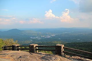
Black Rock Mountain State Park is a 1,743-acre (705 ha) Georgia, United States, state park west of Mountain City in Rabun County, in the Blue Ridge Mountains. It is named after its sheer cliffs of dark-colored biotite gneiss. Astride the Eastern Continental Divide at an elevation of 3,640 feet (1,110 m), the park provides many scenic overlooks and 80-mile (130 km) vistas of the southern Appalachian Mountains. On a clear day, four states are visible: Georgia, North Carolina, South Carolina, and Tennessee. In addition to Black Rock Mountain itself, the park includes four other peaks over 3,000 feet (910 m) in elevation, making it the state's highest state park. As of 2019, it was open to visitors year round.

<span class="mw-page-title-main">Worthington State Forest</span> State forest in New Jersey

Worthington State Forest is a state forest located in Warren County, New Jersey within the Delaware Water Gap National Recreation Area, just north of the water gap in the Skylands Region of the state. It covers an area of 6,660 acres (27.0 km2) and stretches for more than 7 miles (11 km) along the Kittatinny Ridge near Columbia. The park offers hiking, camping and canoeing and kayaking on the Delaware River. There are nearly 20 miles (32 km) of hiking trails within the park, including 7 miles (11 km) of the Appalachian Trail, which passes through the park. The park is operated and maintained by the New Jersey Division of Parks and Forestry.

<span class="mw-page-title-main">Scouting in Maine</span> Youth movements

Scouting in Maine dates back to the creation of the Katahdin Area Council in 1920 and has continued prominently to the present day.

<span class="mw-page-title-main">Mount Blue (Maine)</span>

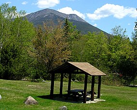
Mount Blue is a mountain in Maine, USA. It is a hiking destination with outstanding views from the observation deck of a tower at the summit. Its name is shared with Mount Blue State Park in Weld and Mount Blue High School in Farmington.

<span class="mw-page-title-main">Swartswood State Park</span> State park in Sussex County, New Jersey

Swartswood State Park is a 3,460-acre (14.0 km2) protected area located in the Swartswood section of Stillwater and Hampton townships in Sussex County, New Jersey, in the United States. Established in 1915 by the state's Forest Park Reservation Commission, it was the first state park established by the state of New Jersey for the purposes of recreation at the state's third-largest freshwater lake. Today, Swartswood State Park is operated and maintained by the New Jersey Division of Parks and Forestry.

<span class="mw-page-title-main">Moxie Falls</span> Body of water

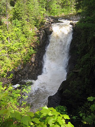
Moxie Falls is a waterfall in Somerset County, Maine. At a vertical drop of over 90 feet (30 m) into a pool about 17 feet (5 m) deep, Moxie Falls is one of the highest falls in New England. The falls are part of Moxie Stream which flows from Moxie Pond into the Kennebec River approximately 1 kilometer (0.62 mi) downstream the falls. Moxie Stream drains Moxie Pond approximately 5 miles (8.0 km) upstream of the falls.

The Appalachian National Scenic Trail spans 14 U.S. states over its roughly 2,200 miles (3,500 km): Georgia, North Carolina, Tennessee, Virginia, West Virginia, Maryland, Pennsylvania, New Jersey, New York, Connecticut, Massachusetts, Vermont, New Hampshire, and Maine. The southern end is at Springer Mountain, Georgia, and it follows the ridgeline of the Appalachian Mountains, crossing many of its highest peaks and running almost continuously through wilderness before reaching the northern end at Mount Katahdin, Maine.

<span class="mw-page-title-main">Crocker Mountain (Maine)</span> Mountain in United States of America

Crocker Mountain is a 4,228 ft (1,289 m) peak located in Carrabassett Valley, Franklin County, Maine, in the United States. Crocker Mountain is the fourth highest mountain in the state after the Katahdins and Sugarloaf Mountain, and is part of the Appalachian Mountains. Crocker Mountain is traversed by the Appalachian Trail (AT), a 2,170 mi (3,490 km) National Scenic Trail from Georgia to Maine.

<span class="mw-page-title-main">Gulf Hagas</span>

Gulf Hagas is a gorge located in the mountains of northern Maine woods and is often referred to as the Grand Canyon of Maine. The West Branch of the Pleasant River cuts through the earth for three miles creating a vertically walled slate gorge with numerous waterfalls. A trail follows the rim of the canyon offering hikers views of the falls and its geology. The gorge is 3 miles (4.8 km) long; the river drops 370 feet (110 m) in this distance boasting 130 feet (40 m) walls. Gulf Hagas is one of 14 National Natural Landmarks in the State of Maine, and is open to the public for a fee during the regular season.

<span class="mw-page-title-main">North Brother</span>

North Brother is a mountain located in Baxter State Park, Piscataquis County, Maine. North Brother is flanked to the northeast by Fort Mountain, and to the southwest by South Brother; collectively the two are called "The Brothers."

South Brother is a mountain located in Piscataquis County, Maine, in Baxter State Park. South Brother is flanked to the southwest by Mount Coe, and to the northeast by North Brother; collectively the two are called "The Brothers".

The High Peaks is a region of the US state of Maine, lying entirely within Franklin County. It is roughly bounded by State Route 4 to the southwest, State Route 16 to the northwest, State Route 16/27 to the northeast and State Route 142 to the southeast. The region contains eight of the 14 Maine 4,000-footers and includes 21,000 acres (85 km2) contiguously above 2,700 feet (820 m). By comparison, Baxter State Park, which contains Maine's highest mountain, Mount Katahdin, and has a similar overall land area, has roughly 15% less contiguous land over 2700 feet. The Appalachian Trail passes through the area, covering a distance of 32.2 miles (52 km) and climbing a total of 10,000 feet (3,000 m).

<span class="mw-page-title-main">Sugarite Canyon State Park</span> State park in New Mexico, United States

Sugarite Canyon State Park is a state park of New Mexico, United States, featuring a historic early-20th century coal-mining camp and natural scenery at the border of the Rocky Mountains and the Great Plains. The park is located on the Colorado–New Mexico state line 6 miles (9.7 km) northeast of Raton, New Mexico.

<span class="mw-page-title-main">Black Cap Mountain</span> Mountain in Maine, United States of America

Black Cap Mountain is a 1,020 foot (310 m) mountain in Penobscot County, Maine, United States. The mountain is 5 miles (8.0 km) southeast of Eddington, Maine, and the Penobscot River. It is accessible from Maine Route 46, near its intersection with The Airline.

<span class="mw-page-title-main">Enchanted Pond</span> Body of water

Enchanted Pond is a mountain pond in the U.S. state of Maine. Situated in the Western Maine Mountains in the Northwest Somerset Region, the pond is located in a deep mountain valley between Coburn Mountain and Shutdown Mountain. Near its southern end, the pond is distinguished by two rockslides from the exposed cliffs of these mountains that extend down into the water along both shores. Enchanted Pond is fed by mountain springs and Little Enchanted Pond, and is the primary source of Enchanted Stream which flows into the Dead River, a tributary of the Kennebec River. Development on the pond is limited to a small set of sporting camps at the northern end of the pond and one remote camp on the southwest shore, both a part of Bulldog Camps. There are no islands in the pond.

References

  1. Jermanok, Stephen (September 24, 2006). "Delicate Terrain". The Boston Globe Magazine. The Boston Globe . Retrieved September 24, 2006.
  2. "2018 Annual Report.pdf". Google Docs. Retrieved May 19, 2020.
  3. National Geographic's guide to the state parks of the United States
  4. "Treat Your Water". Baxter State Park. April 14, 2017. Retrieved May 14, 2018.
  5. 1 2 Whitcomb, Howard R., 1939- (2008). Governor Baxter's Magnificent Obsession: A documentary history of Baxter State Park 1931-2006. Bangor, Me.: Friends of Baxter State Park. ISBN   978-1-887940-15-3. OCLC   253652001.{{cite book}}: CS1 maint: multiple names: authors list (link)
  6. "History". Baxter State Park. January 5, 2017. Retrieved August 27, 2020.
  7. "Director's Page". Baxter State Park. Archived from the original on June 21, 2007.
  8. Percival P. Baxter, quoted in "Katahdin Section Guide to The Appalachian Trail in Maine"
  9. Nick Sambides Jr. (May 30, 2013). "Oakland couple to retire from restoring Pockwockamus Rock mural at Baxter State Park". Bangor Daily News. Archived from the original on October 18, 2016. Retrieved October 16, 2016.
  10. "Collection: John W. Hakola Papers | Fogler Library Special Collections and Archives ArchivesSpace". University of Maine.
  11. Kellogg, Edward S. (1983). "Legacy of a Lifetime: The Story of Baxter State Park. By John W. Hakola. (Woolwich, Maine: TBW Books for the Baxter State Park Authority, 1981. xviii + 424 pp. Illustrations, tables, maps, appendixes, notes, index. $16)". Forest & Conservation History. 27 (2): 100. doi:10.2307/4004993. ISSN   1046-7009. JSTOR   4004993.