Bay Bulls, Newfoundland and Labrador

Last updated
Bay Bulls
Town
Bay Bulls Newfoundland.jpg
Bay Bulls in August, 2006
Canada Newfoundland location map.svg
Red pog.svg
Bay Bulls
Location of Bay Bulls in Newfoundland
Coordinates: 47°18′57″N52°48′37″W / 47.3158°N 52.8103°W / 47.3158; -52.8103 Coordinates: 47°18′57″N52°48′37″W / 47.3158°N 52.8103°W / 47.3158; -52.8103
Country Canada
Province Newfoundland and Labrador
settled1635-1638
Government
  MayorKeith O'Driscoll
Area
[1]
  Land30.74 km2 (11.87 sq mi)
Population
 (2021) [2]
  Total1,566
  Density48.8/km2 (126/sq mi)
Time zone UTC-3:30 (Newfoundland Time)
  Summer (DST) UTC-2:30 (Newfoundland Daylight)
Area code 709
Highways NL Route 10.svg Route 10
Website www.townofbaybulls.com OOjs UI icon edit-ltr-progressive.svg
Bay Bulls Lighthouse OOjs UI icon edit-ltr-progressive.svg
Bull Head Lighthouse.jpg
Constructed1908  OOjs UI icon edit-ltr-progressive.svg
Foundationconcrete base
Constructioncast iron tower
Height11 m (36 ft)  OOjs UI icon edit-ltr-progressive.svg
Shapecylindrical tower with balcony and lantern
Markingswhite tower and lantern
Power sourcesolar power  OOjs UI icon edit-ltr-progressive.svg
OperatorCanadian Coast Guard [3] [4]
Heritagerecognized federal heritage building of Canada  OOjs UI icon edit-ltr-progressive.svg
Focal height62 m (203 ft)  OOjs UI icon edit-ltr-progressive.svg
Lensfourth ordered Fresnel lens
Range7 nmi (13 km; 8.1 mi)  OOjs UI icon edit-ltr-progressive.svg
Characteristic Fl W 6s  OOjs UI icon edit-ltr-progressive.svg

Bay Bulls (2021 population: 1,566 [2] ) is a small fishing town in the province of Newfoundland and Labrador, Canada.

Contents

Geography

Located in a sheltered bay, it has been home to many fishermen and a strategic location in early times as it is located just a few miles from the capital, St. John's.

History

Bay Bulls first appears on a 1592 map drawn by Thomas Hood.

Fortification of the harbour came in 1638 by Governor David Kirke. In 1665, Bay Bulls was raided by Dutch sailors under Admiral De Ruyter. During King William's War, the village was attacked twice. In 1696, Monbeton de St. Ovide de Brouillan, the governor of Placentia, attacked Bay Bulls from the sea, resulting in the scuttling of the English warship HMS Sapphire. Then in 1697 Pierre Le Moyne d'Iberville marched overland from Placentia and attacked Bay Bulls in the Avalon Peninsula Campaign. In 1702, Commodore John Leake of the Royal Navy entered Bay Bulls with several Men of War, and received information about the whereabouts of French ships and unprotected settlements around the Avalon Peninsula, which he then attacked. On June 24, 1762, the French led by Admiral d'Arsac de Ternay, landed seven hundred men who occupied Bay Bulls and marched to St. John's. Bay Bulls suffered its last invasion on September 29, 1796, when Admiral Richery attempted to storm St. John's but finding it well defended; he attacked and burned Bay Bulls instead.

In 1890 the Roman Catholic Church, St. Peter and St. Paul was rebuilt. The gate was initially marked by cannons left over from the battles with the French, then statues of the Saints were added on top, which gave the famous "Canonized Saints of Bay Bulls."

Demographics

In the 2021 Census of Population conducted by Statistics Canada, Bay Bulls had a population of 1,566 living in 597 of its 631 total private dwellings, a change of

Economy

Bay Bulls is a fishing community and was established because it is close to the rich fishing grounds on the Grand Banks. Due to its proximity to St. John's, the town is becoming more of a bedroom community for people employed there. Bay Bulls has been at the forefront of many strategies such as fish farming and lately servicing the Oil and Gas industry. The Penney Group of Companies has built a repair facility that services the many oil rigs that drill for oil on the Grand Banks. Tourism has become an important part of the community as well. Four whale and bird watching establishments, as well as several bed-and-breakfast places, attract visitors from all over the world.

See also

Related Research Articles

<span class="mw-page-title-main">Avondale, Newfoundland and Labrador</span> Town in Newfoundland and Labrador, Canada

Avondale is a town located on Newfoundland's Avalon Peninsula in the province of Newfoundland and Labrador, Canada.

<span class="mw-page-title-main">Conception Harbour</span> Town in Newfoundland and Labrador, Canada

Conception Harbour is a town on the Avalon Peninsula in Newfoundland and Labrador, Canada. It is in Division 1 on Conception Bay and can be accessed via Newfoundland and Labrador Route 60.

Whitbourne is a town on the Avalon Peninsula in Newfoundland and Labrador, Canada in Division 1.

<span class="mw-page-title-main">Arnold's Cove</span> Town in Newfoundland and Labrador, Canada

Arnold's Cove is a town on Newfoundland's Avalon Peninsula in the province of Newfoundland and Labrador, Canada. It is in Division 1 on Placentia Bay.

<span class="mw-page-title-main">Ferryland</span> Town in Newfoundland and Labrador, Canada

Ferryland is a town in Newfoundland and Labrador on the Avalon Peninsula. According to the 2021 Statistics Canada census, its population is 371.

<span class="mw-page-title-main">Division No. 1, Newfoundland and Labrador</span> Census division in Newfoundland and Labrador, Canada

Division 1, Newfoundland and Labrador is a census division covering the entire Avalon Peninsula including the Isthmus of Avalon of the Canadian province of Newfoundland and Labrador. Like all census divisions in Newfoundland and Labrador, but unlike the census divisions of some other provinces, the division exists only as a statistical division for census data, and is not a political entity.

<span class="mw-page-title-main">Avalon (electoral district)</span> Federal electoral district in Newfoundland and Labrador, Canada

Avalon is a federal electoral district on Newfoundland Island in Newfoundland and Labrador, Canada. It has been represented in the House of Commons of Canada since 2004.

<span class="mw-page-title-main">Channel-Port aux Basques</span> Town in Newfoundland and Labrador, Canada

Channel-Port aux Basques is a town at the extreme southwestern tip of Newfoundland fronting on the western end of the Cabot Strait. A Marine Atlantic ferry terminal is located in the town which is the primary entry point onto the island of Newfoundland and the western terminus of the Newfoundland and Labrador Route 1 in the province. The town was incorporated in 1945 and its population in the 2021 census was 3,547.

<span class="mw-page-title-main">Placentia, Newfoundland and Labrador</span> Town in Newfoundland and Labrador, Canada

Placentia is a town located in the Canadian province of Newfoundland and Labrador. It consists of the Argentia Industrial Park and amalgamated communities of Townside, Freshwater, Dunville, Southeast, Point Verde and Jerseyside.

<span class="mw-page-title-main">Grand Bank</span> Town in Newfoundland and Labrador, Canada

Grand Bank or 'Grand Banc' as the first French settlers pronounced it, is a small rural town in the Canadian province of Newfoundland and Labrador, with a population of 2,580. It is located on the southern tip or "toe" of the Burin Peninsula, 360 km from the province's capital of St. John's.

<span class="mw-page-title-main">Old Perlican</span> Town in Newfoundland and Labrador, Canada

Old Perlican is a fishing village on the Avalon Peninsula, Newfoundland and Labrador in Canada. Incorporated in 1971, it is one of the oldest fishing communities in Newfoundland; it served as the major fishing station in Trinity Bay for migratory fisherman from England in the 17th century.

<span class="mw-page-title-main">Trepassey</span> Town in Newfoundland and Labrador, Canada

Trepassey is a small fishing community located in Trepassey Bay on the south eastern corner of the Avalon Peninsula of Newfoundland and Labrador. It was in Trepassey Harbour where the flight of the Friendship took off, with Amelia Earhart on board, the first woman to fly across the Atlantic Ocean.

Hant's Harbour is an incorporated town located on the east side of Trinity Bay on the Bay de Verde Peninsula in the province of Newfoundland and Labrador, Canada. It has a population of 318 according to the 2021 Canadian census.

<span class="mw-page-title-main">Harbour Grace</span> Town in Newfoundland and Labrador, Canada

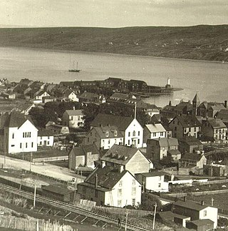
Harbour Grace is a town in Conception Bay on the Avalon Peninsula in the province of Newfoundland and Labrador, Canada. With roots dating back to the 16th century, it is one of the oldest towns in North America.

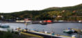
Brigus is a small fishing community located in Conception Bay, Newfoundland and Labrador, Canada. Brigus was home to Captain Bob Bartlett and the location of his residence Hawthorne Cottage.

<span class="mw-page-title-main">Bay Roberts</span> Town in Newfoundland and Labrador, Canada

Bay Roberts is located on the north shore of Conception Bay on the northeastern Avalon Peninsula in the province of Newfoundland and Labrador, Canada. The growth of the local economy can be connected to the town's proximity to other major Newfoundland markets, by road and by water.

<span class="mw-page-title-main">Fox Harbour, Newfoundland and Labrador</span> Town in Newfoundland and Labrador, Canada

Fox Harbour is a small community on the Avalon Peninsula of Newfoundland. According to Statistics Canada in 2011, the population was 270. It is surrounded by hills. It is located close to Argentia, the site of the Naval Station Argentia. According to some sources, Fox Harbour got its name from tales of foxes that came down from the surrounding hills and ate the drying fish on the flakes. As well, the community was called Little Glocester before it became officially named Fox Harbour.

Admirals Beach is a rural community located in Newfoundland and Labrador, Canada.

Division No. 1, Subdivision B is an unorganized subdivision on the Avalon Peninsula in Newfoundland and Labrador, Canada. It is in Division 1 and contains the unorganized communities of Iona, Little Barasway, Placentia Junction, Point Verde and Ship Harbour.

<span class="mw-page-title-main">Little Placentia Sound, Newfoundland and Labrador</span> Abandoned Town in Newfoundland and Labrador, Canada

Little Placentia Sound is an abandoned town in Newfoundland and Labrador that had a peak population of 47 in 1901. It is named after the body of water (sound) that encompasses the former community located within Placentia Bay on the Avalon Peninsula in the Canadian province of Newfoundland and Labrador. There was once a lead mine called Silver Cliff Mine located within the town.

References

  1. "Census Profile - Bay Bulls". Statistics Canada. Retrieved 29 October 2016.
  2. 1 2 3 "Population and dwelling counts: Canada, provinces and territories, census divisions and census subdivisions (municipalities), Newfoundland and Labrador". Statistics Canada. February 9, 2022. Retrieved March 15, 2022.
  3. Rowlett, Russ. "Lighthouses of Canada: Southeastern Newfoundland". The Lighthouse Directory. University of North Carolina at Chapel Hill . Retrieved 2017-02-06.
  4. List of Lights, Pub. 110: Greenland, The East Coasts of North and South America (Excluding Continental U.S.A. Except the East Coast of Florida) and the West Indies (PDF). List of Lights . United States National Geospatial-Intelligence Agency. 2016.