Bayamo

Last updated
Bayamo
Boulevard of Bayamo.jpg
The "Boulevard" of Bayamo
Cespedes flag.svg
Coat of arms of the city of Bayamo.svg
Bayamo (Cuban municipal map).png
Bayamo municipality (red) in
Granma Province (yellow) and Cuba
Coordinates: 20°22′54″N76°38′34″W / 20.38167°N 76.64278°W / 20.38167; -76.64278
Country Cuba
Province Granma
EstablishedNovember 15, 1513 [1]
Incorporated 1827 (city)
Government
  PresidentReydier Bernal Gómez
Area
[2]
   Municipality 918 km2 (354 sq mi)
Elevation
55 m (180 ft)
Population
 (2022) [3]
   Municipality 236,826
  Density260/km2 (670/sq mi)
   Urban
169,209
   Rural
67,617
Time zone UTC-5 (EST)
Postal code
85100
Area code +53 23
Vehicle registration G
Website https://www.bayamo.gob.cu/es/
Urban agriculture in Bayamo Urban-agriculture-cuba-1.jpg
Urban agriculture in Bayamo

Bayamo is the capital city of the Granma Province of Cuba and one of the largest cities in the Oriente region.

Contents

Overview

The community of Bayamo lies on a plain by the Bayamo River. It is affected by the violent Bayamo wind.

One of the most important education institutions in the province is the University of Granma.

History

Established in 1513, Bayamo was the second of seven cities founded by Diego Velázquez de Cuéllar. [4] Francisco Iznaga, [5] a Basque landowner in the western portion of Cuba during the first 30 years of the colonization of Cuba, was elected mayor in 1540. Iznaga was the originator of a powerful lineage that finally settled in Trinidad, where the Torre Iznaga (Iznaga Tower) is. His descendants fought for the independence of Cuba and for annexation to the U.S., from 1820 to 1900.

During much of the 16th century it was one of the most important agricultural and commercial settlements of the island. Its inland situation gave it relative security against the pirates who infested West Indian seas, and the misfortunes of Santiago were the fortunes of Bayamo. Down the Cauto River, then open to the sea for vessels of 200 tons, and through Manzanillo, Bayamo drove a thriving contraband trade that made it the leading town of Cuba at the opening of the 17th century. [4]

A tremendous flood, in 1616, choked the Cauto with trees and wrecked vessels, cutting it off from direct access to the sea; but through Manzanillo it continued a great clandestine traffic with Curaçao, Jamaica, and other foreign islands throughout the 17th and 18th centuries. Bayamo was then surrounded by fine plantations. [4]

In 1827 it acquired the status of city. In the war of 18681878 it was an insurgent stronghold. One of the most desperate conflicts of the war was fought nearby, and it was nearly destroyed by the opposing parties. [4]

Demographics

In 2022, the municipality of Bayamo had a population of 236,826. [3] With a total area of 918 km2 (354 sq mi), [2] it has a population density of 242.0/km2 (627/sq mi). The urban population was 169,209. [6]

Transportation

Bayamo is an under-recognized world leader in sustainable transportation. Per a UN study only about 15% of commuters rely on motorized transport and almost three times as many (39%) rely on about 500 licensed horse-drawn carriages generally following fixed routes. The rest of the non-pedestrian traffic is bicycle and bicycle taxi. [7] [8]

Carlos Manuel de Céspedes Airport satisfies the city's commercial aviation needs; it has had service to Havana on Cubana Airlines.

Notable residents

See also

Related Research Articles

<span class="mw-page-title-main">Flag of Cuba</span> National flag

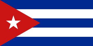
The national flag of Cuba consists of five alternating stripes and a red equilateral triangle at the hoist, within which is a white five-pointed star. It was designed in 1849 and officially adopted May 20, 1902. The flag is referred to as the Estrella Solitaria, or the Lone Star flag. It is in the stars and stripes flag family.

<span class="mw-page-title-main">Trinidad, Cuba</span> Municipality in Sancti Spíritus, Cuba

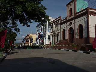
Trinidad is a town in the province of Sancti Spíritus, central Cuba. Together with the nearby Valle de los Ingenios, it has been a UNESCO World Heritage Site since 1988, because of its historical importance as a center of the sugar trade in the 18th and 19th centuries. Trinidad is one of the best-preserved cities in the Caribbean from the time when the sugar trade was the main industry in the region.

<span class="mw-page-title-main">Ten Years' War</span> 1868–1878 Cuban uprising against Spanish rule

The Ten Years' War, also known as the Great War and the War of '68, was part of Cuba's fight for independence from Spain. The uprising was led by Cuban-born planters and other wealthy natives. On 10 October 1868, sugar mill owner Carlos Manuel de Céspedes and his followers proclaimed independence, beginning the conflict. This was the first of three liberation wars that Cuba fought against Spain, the other two being the Little War (1879–1880) and the Cuban War of Independence (1895–1898). The final three months of the last conflict escalated with United States involvement, leading to the Spanish–American War.

<span class="mw-page-title-main">Sancti Spíritus</span> Municipality in Province of Sancti Spíritus, Cuba

Sancti Spíritus is a municipality and capital city of the province of Sancti Spíritus in central Cuba and one of the oldest Cuban European settlements. Sancti Spíritus is the genitive case of Latin Sanctus Spiritus.

<span class="mw-page-title-main">Manzanillo, Cuba</span> Municipality in Granma, Cuba

Manzanillo is a municipality and city in the Granma Province of Cuba. By population, it is the 14th-largest Cuban city and the most populated one not being a provincial seat.

<span class="mw-page-title-main">Palma Soriano</span> District in Oriente, Cuba

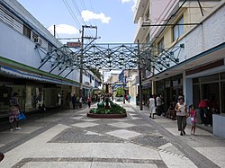
Palma Soriano is a Cuban city and municipality in the Santiago de Cuba Province. With a population of 119,740 in the city proper, it is the second-largest in the province and the 16th-largest in Cuba.

<span class="mw-page-title-main">Las Tunas (city)</span> Municipality in Las Tunas, Cuba

Las Tunas is a city and municipality in central-eastern Cuba. It is the capital of the Las Tunas Province and was named Victoria de Las Tunas from 1869 to 1976.

<span class="mw-page-title-main">Yara, Cuba</span> Municipality in Granma, Cuba

Yara is a small town and municipality in the Granma Province of Cuba, located halfway between the cities of Bayamo and Manzanillo, in the Gulf of Guacanayabo. Yara means "place" in the Taíno language.

<span class="mw-page-title-main">Florida, Cuba</span> Municipality in Camagüey, Cuba

Florida is a municipality and city in the Camagüey Province of Cuba. It is located 40 km (25 mi) north-west of Camagüey, along the Carretera Central highway. The city was established in 1907, and the municipality was established in 1924. Of all the municipalities of the Cuban province of Camagüey, Florida is third in area size. The name is Spanish for Land of flowers.

<span class="mw-page-title-main">Alazanes de Granma</span> Baseball team

Alazanes de Granma is a baseball team in the Cuban National Series, based in the eastern province of Granma. Until the 2016-2017 season, the Alazanes were a frequent contender, but had never advanced to a National Series final. However, in 2017 Granma not only made it to the Cuban National Series final, but swept Ciego de Ávila to win the series, breaking a 40-year record of being seen as underdogs who could not compete with dominant powerhouse teams.

<span class="mw-page-title-main">Francisco Vicente Aguilera</span> Cuban patriot

Francisco Vicente Aguilera was a Cuban patriot born in Bayamo, Cuba on June 23, 1821. He had ten children with his wife Ana Manuela Maria Dolores Sebastiana Kindelan y Sanchez. He studied at the University of Havana receiving the degree of Bachelor of Laws.

Carlos Manuel de Céspedes Airport is a regional airport serving the city of Bayamo in the Granma Province of Cuba. It is named for Carlos Manuel de Céspedes.

<span class="mw-page-title-main">Urbano Noris</span> Municipality in Holguín, Cuba

Urbano Noris is a municipality and city in the Holguín Province of Cuba. The municipal seat is located in the town of San Germán.

<span class="mw-page-title-main">Buey Arriba</span> Municipality in Granma, Cuba

Buey Arriba is a municipality and town in the Granma Province of Cuba. It is located 30 kilometres (19 mi) south of Bayamo, the provincial capital.

<span class="mw-page-title-main">Cauto Cristo</span> Municipality in Granma, Cuba

Cauto Cristo is a municipality and town in the Granma Province of Cuba. It is located on the banks of the Río Cauto, in the western part of the province, bordering the provinces of Holguín and Las Tunas.

<span class="mw-page-title-main">Río Cauto, Cuba</span> Municipality in Granma, Cuba

Río Cauto is a municipality and town in the Granma Province of Cuba. It is located in the northern part of the province, upstream of the mouth of Cauto River.

<span class="mw-page-title-main">Bartolomé Masó</span>

Bartolomé de Jesús Masó Márquez was a Cuban politician and military, patriot for Cuban independence from the colonial power of Spain, and later President of the República en Armas.

<span class="mw-page-title-main">Úrsula Céspedes</span> Cuban poet

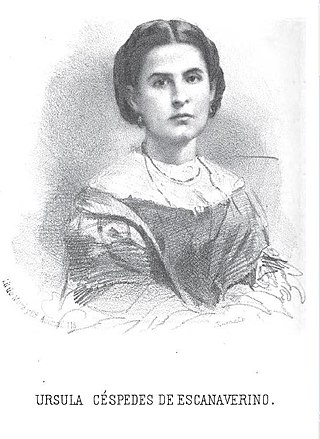
Úrsula Céspedes was a Cuban poet and founder of the Academia Santa Úrsula in Manzanillo, Cuba, originally from Bayamo, Cuba.

<span class="mw-page-title-main">Circuito Sur de Oriente</span>

The Circuito Sur de Oriente (CSO), meaning "Southern Circuit of the Orient", is a west-east highway connecting Bayamo to Santiago de Cuba, through Manzanillo, Niquero and the southern coastal side of eastern Cuba, below the Sierra Maestra mountain range. Also known as Circuito Guacanayabo-Sur de Oriente, because it crosses the Gulf of Guacanayabo, the name Oriente, refers to the ancient and former Oriente Province. With a length of 347 km, it is the fourth-longest Cuban highway after the "Carretera Central", the "Circuito Norte" and the "Circuito Sur".

<span class="mw-page-title-main">Battle of Peralejo</span>

The Battle of Peralejo was a military confrontation between Cuban independence rebels, under the command of Major General Antonio Maceo against the forces of the Spanish Army, under the command of Captain General Arsenio Martínez Campos, which was part of Maceo's First Eastern Campaign during the Cuban War of Independence.

References

  1. Guije.com. "Bayamo" (in Spanish). Archived from the original on 13 October 2007. Retrieved 2007-10-06.
  2. 1 2 Statoids (July 2003). "Municipios of Cuba". Archived from the original on 12 October 2007. Retrieved 2007-10-06.
  3. 1 2 "Cuba: Administrative Division (Provinces and Municipalities) - Population Statistics, Charts and Map". www.citypopulation.de. Retrieved 2024-02-03.
  4. 1 2 3 4 Wikisource-logo.svg One or more of the preceding sentences incorporates text from a publication now in the public domain :  Chisholm, Hugh, ed. (1911). "Bayamo". Encyclopædia Britannica . Vol. 3 (11th ed.). Cambridge University Press. pp. 553–554.
  5. Jorge Iznaga. FRANCISCO IZNAGA Iznaga Genealogy (IZNAGA - 1420 - Present), Retrieved 5 December 2012.
  6. "Bayamo (Municipality, Cuba) - Population Statistics, Charts, Map and Location". www.citypopulation.de. Retrieved 2024-02-03.
  7. "Getting the carriages out, Cuban-style". UN-HABITAT. 2004-07-20. Archived from the original on 2017-07-31. Retrieved 2017-07-31.
  8. Jon Petrie. "Bayamo, an unacknowledged leader in horse dependent/ ecological transport". Lonely Planet. Archived from the original on 2017-07-31. Retrieved 2017-07-31.

Commons-logo.svg Media related to Bayamo at Wikimedia Commons