Bella Coola, British Columbia

Last updated

Bella Coola
Bella Coola Consumers Co-op - panoramio.jpg
Bella Coola Consumers Co-op
Canada British Columbia location map 2.svg
Red pog.svg
Bella Coola
Coordinates: 52°22′N126°45′W / 52.367°N 126.750°W / 52.367; -126.750
Country Canada
Province British Columbia
Regional district Central Coast
Population
  Total2,163
Highways BC-20.svg Hwy 20
Website bellacoola.ca OOjs UI icon edit-ltr-progressive.svg

Bella Coola is an unincorporated community in the Bella Coola Valley of British Columbia, Canada. Bella Coola usually refers to the entire valley, encompassing the settlements of Bella Coola proper ("the townsite"), Lower Bella Coola, Hagensborg, Salloompt, Nusatsum, Firvale, and Stuie. It is also the location of the head offices of the Central Coast Regional District.

Contents

The entire Bella Coola Valley has a population of 2,163 as of the 2021 census. This was an increase of 8% from the 2016 census, when the population was 2,007.

Geography

The primary geographical structure of the community, both in terms of physical structures and population distribution, is the long, narrow Bella Coola River valley. The river meanders along the eastern and northern edges of the town before discharging into the head of North Bentinck Arm.

Highway 20 (known over most of its length as the Chilcotin Highway) stretches from the Government wharf (on the Pacific Ocean) through the extent of the populated portion of the valley before climbing to the Chilcotin Plateau, and the entire population of the community lives either on this road or very near to it.

In recent years, the mountainous terrain around and accessible from the Bella Coola Valley has been advertised for heliskiing. The Bella Coola has been ranked as having the World's Best Heliskiing Operation since 2017, [1] [2] and has held this title consistently every year since. Several skiing movies have been filmed in the area. [3] [4]

Name

"Bella Coola" is an exonym and corruption of the Heiltsuk bḷ́xʷlá, meaning "somebody from Bella Coola" or "stranger". The Nuxalk endonym for the local region is "Nuxalk", and the endonym for the specific village site of Bella Coola is "Q'umk'uts" [5] The name Bella Coola has been used to refer to the entire Bella Coola valley, and at times to the entire ethnic region, not to any village in particular. Increasingly the term "Nuxalk Territory" is used for the entire region, and Bella Coola refers specifically to the river valley. Sir Alexander Mackenzie referred to it as 'Rascal's Village'. [6] :19

Climate

Bella Coola's climate is a moderate oceanic climate (Köppen Cfb) due to its proximity to the Pacific Ocean, falling exactly on the borderline with the warm-summer humid continental climate (Köppen Dfb) and close to the warm-summer Mediterranean climate (Köppen Csb) and the warm-summer continental Mediterranean climate (Köppen Dsb). However, its summers are warmer than coastal places much further south due to its semi-inland position. The maritime air is made warmer by the passage of the outer islands, but is stronger in terms of winter moderation. This results in a climate that far belies its northerly latitude in North America. There is a strong drying tendency in summer, but remains above the dry-summer climates that are often referred to as cs climates (mediterranean).

The highest temperature ever recorded in Bella Coola was 41.2 °C (106.2 °F) on 30 July 2009. [7] The coldest temperature ever recorded was −28.9 °C (−20 °F) on 15 January 1950. [8]

Climate data for Bella Coola Airport, 1981–2010 normals, extremes 1895–present
MonthJanFebMarAprMayJunJulAugSepOctNovDecYear
Record high humidex 15.316.623.028.536.037.042.739.133.726.414.913.642.7
Record high °C (°F)18.9
(66.0)
17.3
(63.1)
25.0
(77.0)
29.4
(84.9)
37.8
(100.0)
36.3
(97.3)
41.2
(106.2)
37.8
(100.0)
33.3
(91.9)
25.0
(77.0)
20.0
(68.0)
16.0
(60.8)
41.2
(106.2)
Mean daily maximum °C (°F)3.0
(37.4)
5.9
(42.6)
9.9
(49.8)
14.3
(57.7)
18.1
(64.6)
20.7
(69.3)
23.0
(73.4)
22.7
(72.9)
18.7
(65.7)
12.2
(54.0)
5.5
(41.9)
2.4
(36.3)
13.0
(55.4)
Daily mean °C (°F)0.2
(32.4)
2.1
(35.8)
5.0
(41.0)
8.6
(47.5)
12.1
(53.8)
15.1
(59.2)
17.3
(63.1)
17.0
(62.6)
13.4
(56.1)
8.3
(46.9)
2.8
(37.0)
0.0
(32.0)
8.5
(47.3)
Mean daily minimum °C (°F)−2.6
(27.3)
−1.8
(28.8)
0.1
(32.2)
2.9
(37.2)
6.1
(43.0)
9.5
(49.1)
11.4
(52.5)
11.2
(52.2)
8.0
(46.4)
4.3
(39.7)
0.1
(32.2)
−2.4
(27.7)
3.9
(39.0)
Record low °C (°F)−28.9
(−20.0)
−24.4
(−11.9)
−20.6
(−5.1)
−9.4
(15.1)
−6.1
(21.0)
−1.1
(30.0)
1.1
(34.0)
−1.1
(30.0)
−4.4
(24.1)
−14.0
(6.8)
−24.5
(−12.1)
−24.4
(−11.9)
−28.9
(−20.0)
Record low wind chill −32.7−36.8−26.2−9.70.00.00.00.0−2.6−21.8−39.4−30.6−39.4
Average precipitation mm (inches)157.2
(6.19)
87.6
(3.45)
76.4
(3.01)
55.7
(2.19)
47.8
(1.88)
51.1
(2.01)
42.3
(1.67)
60.3
(2.37)
90.1
(3.55)
194.9
(7.67)
204.9
(8.07)
130.8
(5.15)
1,199.1
(47.21)
Average rainfall mm (inches)131.1
(5.16)
72.4
(2.85)
71.2
(2.80)
55.2
(2.17)
47.8
(1.88)
51.1
(2.01)
42.3
(1.67)
60.3
(2.37)
90.1
(3.55)
193.1
(7.60)
180.4
(7.10)
102.8
(4.05)
1,097.8
(43.22)
Average snowfall cm (inches)30.3
(11.9)
17.2
(6.8)
5.7
(2.2)
0.6
(0.2)
0.0
(0.0)
0.0
(0.0)
0.0
(0.0)
0.0
(0.0)
0.0
(0.0)
2.2
(0.9)
26.0
(10.2)
30.1
(11.9)
112.0
(44.1)
Average precipitation days (≥ 0.2 mm)18.213.316.114.715.715.813.412.914.621.121.118.3195.1
Average rainy days (≥ 0.2 mm)14.811.615.514.715.715.813.412.914.621.019.514.9184.3
Average snowy days (≥ 0.2 cm)6.03.51.50.30.00.00.00.00.00.44.47.023.1
Average relative humidity (%)78.565.555.950.350.353.553.356.061.972.982.482.463.6
Mean monthly sunshine hours 16.868.8119.6160.2203.7198.2231.8206.8156.680.820.27.81,471.4
Percent possible sunshine 6.524.632.638.441.839.546.045.441.124.57.73.229.3
Source: [9] [8] [7] [10]

Transport

The wharf at Bella Coola Bella coola docks.jpg
The wharf at Bella Coola

Road

There is a 454 km mostly paved road connection by Highway 20 to Williams Lake. The 137 kilometre section from Bella Coola to Anahim Lake was built in 1953 by local residents, and features a 15 km ascent from the Valley floor to the Chilcotin plateau, gaining 1600 metres in elevation to the summit at Heckman Pass, via a number of steep grades & switchbacks. The construction of this road was described in the books "Bella Coola" and "A Road Runs West".

Air

Bella Coola is served by the Bella Coola Airport (on Highway 20, in Hagensborg), 14 km distant from the townsite which has a 1,280 metre runway made of asphalt. Pacific Coastal Airlines offers scheduled traffic to Vancouver and Anahim Lake. Charter services by both plane and helicopter are also available. [11]

Marine ferry

BC Ferries provides service from Bella Coola. Since its re-establishment in 1998, this service has connected to Bella Bella, and usually to Port Hardy on Vancouver Island, with various other intermediate destinations served at different times. Currently (2023), using the vessel Northern Sea Wolf, the service includes regular (once per week or more often) voyages to Port Hardy (Bear Cove), Bella Bella (McLoughlin Bay) and Ocean Falls, with greater frequency in the summer.

The sailing schedule varies throughout the season. [12]

History

The Nuxalk people were present in the Bella Coola valley prior to any formal written history of the area. This is confirmed both by oral history that continues unbroken to present day, and by written history of some of the first European explorers of the area.

In 1793, Alexander MacKenzie arrived from the east, completing the first recorded crossing of the continent north of Mexico.

Immigration (non-Nuxalk) to the region was sporadic and often temporary for the next century. A Hudson's Bay fur trading post was set up at the mouth of the river (the land granted to the post forms the off-reserve portion of the present-day "townsite"), and a handful of farmers were granted land farther up the valley. The trading trails of the Nuxalk and neighbouring nations became a popular route from the Pacific Ocean to central British Columbia, particularly during the Cariboo Gold Rush of the 1860s. In the 1870s, the valley was surveyed as a potential Pacific terminus of the Canadian Pacific Railway; (Burrard Inlet was the eventual choice, its selection giving birth to the city of Vancouver).

In 1894, after their previously-existing community in Minnesota suffered an internal conflict, a group of Norwegian Lutheran settlers were given land grants in the valley, conditional upon land clearing and the construction of residences. The land they were granted, as well as other land previously granted to individuals was, in many cases, land that had been occupied by Nuxalk communities only a few decades (or less) earlier. However, the 1862 Pacific Northwest smallpox epidemic had decimated the Nuxalk population, and the survivors had, for the most part, gathered on land close to the mouth of the river (and close to the Hudson's Bay post). The Norwegian settlement was named Hagensborg and remains one of the main communities of the Bella Coola Valley. Although much of the Norwegian colony's population did migrate away, others stayed to work in forestry and in the development of the fishing industry. The cannery at Tallheo, across the arm from Bella Coola, was founded by a Norwegian settler who had given up on farming in the area.

These two populations (Norwegian settlers and Nuxalk), in varying proportions, continued to make up the vast majority of the community's population for most of the next century. However, in recent years, the Norwegian population (or connection to a Norwegian identity) has declined. In 2001, 43% of the population reported "Aboriginal identity", of which the vast majority is Nuxalk, while only 10% reported Norwegian (or Norwegian-Canadian) to be their "Ethnic Origin".

When the community of Ocean Falls suffered a massive population decline in 1980/81, due to the closure of the town's primary industry (a paper mill), Bella Coola became the administrative centre for British Columbia's central coast. This led to the relocation of the Central Coast Regional District (which, up until that time had been called the "Ocean Falls Regional District") offices to Bella Coola, and a general centralization of government services such as provincial government regional centres (e.g. Ministry of Forests) in Bella Coola.

Economy

Fishing, forestry, public service (government/education), retail and tourism all contribute significantly to the economy. There is some limited agriculture, including an active farmers' market, processing of locally-caught seafood, a number of craftmakers and artists (including several celebrated Nuxalk artisans) and a fish hatchery. The only financial institution in Bella Coola is a branch of the Williams Lake & District Credit Union, heir to a sixty-plus-year tradition of the Bella Coola Valley Credit Union.

In the 2008 film The Incredible Hulk, the main character, Bruce Banner / Hulk concludes the plot by escaping to Bella Coola, where he attempts to control his transformations. Significant footage for the film was shot in and near Bella Coola, though only very limited amounts were retained in the finished product.

Elected representatives

Regional district

The Bella Coola Valley includes Electoral Areas C, D and E of the Central Coast Regional District (CCRD)

Provincial

The Bella Coola Valley is located within the North Coast-Haida Gwaii electoral district of the British Columbia Legislative Assembly. The riding is represented by New Democrat MLA Jennifer Rice.

Federal

The Bella Coola Valley lies within the Canadian Parliamentary riding of Skeena-Bulkley Valley, currently represented by New Democratic MP Taylor Bachrach.

Notable people

See also

Related Research Articles

<span class="mw-page-title-main">British Columbia Highway 20</span> Highway in British Columbia

Highway 20, also known as the Chilcotin Highway, and officially dubbed the Alexander MacKenzie Highway, is one of the two main east–west routes in the Central Interior of British Columbia (the other being Highway 16. The Chilcotin Highway runs 457 km from Williams Lake westward through the Chilcotin region to North Bentinck Arm, an inlet from the Pacific Ocean where the town of Bella Coola is located. As of 2019, all but 42 km has been paved, mostly for expediting the removal of timber from the region, which, like most of British Columbia, is afflicted with pine beetle infestations. Logging traffic and ranch-related traffic on the route can be expected.

<span class="mw-page-title-main">Nuxalk Nation</span> First Nation in British Colombia

The Nuxalk Nation is the band government of the Nuxalk people of Bella Coola, British Columbia. It is a member of the Wuikinuxv-Kitasoo-Nuxalk Tribal Council, and until March 2008 was a member of the Unrepresented Nations and Peoples Organization. The population is 1,479.

<span class="mw-page-title-main">Pacific Ranges</span> Subrange of the Coast Mountains in British Columbia, Canada

The Pacific Ranges are the southernmost subdivision of the Coast Mountains portion of the Pacific Cordillera. Located entirely within British Columbia, Canada, they run northwest from the lower stretches of the Fraser River to Bella Coola and Burke Channel, north of which are the Kitimat Ranges. The Coast Mountains lie between the Interior Plateau and the Coast of British Columbia.

<span class="mw-page-title-main">British Columbia Coast</span> Coastal region of British Columbia, Canada

The British Columbia Coast, popularly referred to as the BC Coast or simply the Coast, is a geographic region of the Canadian province of British Columbia. As the entire western continental coastline of Canada along the Pacific Ocean is in the province, it is synonymous with being the West Coast of Canada.

Dean Channel is the upper end of one of the longest inlets of the British Columbia Coast, 105 km (65.2 mi) from its head at the mouth of the Kimsquit River. The Dean River, one of the main rivers of the Coast Mountains, enters Dean Channel about 9.5 km (5.9 mi) below the head of the inlet, at the community of Kimsquit.

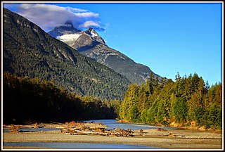
The Bella Coola River is a major river on the Pacific slope of the Coast Mountains in southern British Columbia. The town of Bella Coola is at its mouth on North Bentinck Arm. Bella Coola Indian Reserve No. 1 is the location of the main community today of the surviving population of the Nuxalk who gathered there after depredations by smallpox and colonialization.

<span class="mw-page-title-main">North Bentinck Arm</span> Inlet in the country of Canada

North Bentinck Arm is a short inlet about 17 km (11 mi) in length in the Central Coast region of British Columbia, Canada. It is an arm of Burke Channel and is linked via that waterway and Labouchere Channel to Dean Channel, which is one of the largest inlets of the BC Coast.

Anahim Lake Airport, which serves the west Chilcotin, is about 1.0 nautical mile south of the village of Anahim Lake, British Columbia, Canada.

Tweedsmuir South Provincial Park is a provincial park covering parts of the eastern Kitimat Ranges, northern Pacific Ranges, and the Rainbow Range in British Columbia, Canada. It was established on May 21, 1938 in the western interior of the province, to protect its important natural features. The park hosts a variety of recreation activities for visitors. This park encompasses a range of diverse species in this park including bears, moose, and various fish. There are also a few at risk species in this park.

<span class="mw-page-title-main">Hagensborg</span> Community in the country of Canada

Hagensborg, originally named Kristiania, is a small community in the Bella Coola Valley in British Columbia, Canada. Its census population in 2006 was 248.

<span class="mw-page-title-main">Ilgachuz Range</span> Extinct volcano in British Columbia, Canada

The Ilgachuz Range is a name given to an extinct shield volcano in British Columbia, Canada. It is not a mountain range in the normal sense, because it was formed as a single volcano that has been eroded for the past 5 million years. It lies on the Chilcotin Plateau, located some 350 kilometres (220 mi) north-northwest of Vancouver and 30 km north of Anahim Lake. The highest peak of the range is Far Mountain. The range supports a unique grassland ecosystem. This type of grassland has not been seen anywhere else in central and southern British Columbia. The climate is cool and dry; typical of higher elevations of the Interior Plateau.

<span class="mw-page-title-main">Anahim Peak</span> Mountain in British Columbia, Canada

Anahim Peak, also spelled Anaham, ʔAnaghim, or Anaheim, is a volcanic cone in the Anahim Volcanic Belt in British Columbia, Canada, located 39 km (24 mi) northwest of Anahim Lake and 11 km (7 mi) east of Tsitsutl Peak. It was formed when the North American Plate moved over a hotspot, similar to the one feeding the Hawaiian Islands, called the Anahim hotspot. It is one of the several volcanoes in the Anahim Volcanic Belt that stands out all by itself, rising from the Chilcotin Plateau, between the Rainbow Range and the Ilgachuz Range and near the headwaters of the Dean River.

<span class="mw-page-title-main">Tallheo</span> Place in British Columbia, Canada

Tallheo is the location of a former village of the Nuxalk known as Talyu, and is a former cannery town near Bella Coola, British Columbia, Canada, on North Bentinck Arm. Tallheo is also the name of the dialect of the Nuxalk language spoken by the Talhyumc, the particular subgroup of the Nuxalk who live there.

Tatla Lake is a small unincorporated community in the west Chilcotin area of British Columbia, Canada, located at the west end of its eponymous lake. Situated 220 km west of Williams Lake along Highway 20, Tatla Lake's 123 people live approximately halfway between the two ends of the highway; Williams Lake to the east and the coastal community of Bella Coola to the west. The community is the service centre for three major mountain valleys of West Branch, Chilko and Tatlayoko. These valleys extend southward via secondary roads.

Range 3 Coast Land District is one of the 59 land districts of British Columbia, Canada, which are part of the cadastral divisions of British Columbia.

<span class="mw-page-title-main">Nuxalk</span> Salishan ethnic group of British Columbia, Canada

The Nuxalk people, also referred to as the Bella Coola, Bellacoola or Bilchula, are an Indigenous First Nation of the Pacific Northwest Coast, centred in the area in and around Bella Coola, British Columbia. Their language is also called Nuxalk. Their on-reserve tribal government is the Nuxalk Nation.

The Bella Coola Valley is a relatively small but distinct region located in the Central Coast region of British Columbia, Canada, comprising the valley of the Bella Coola River and its tributaries. The region is served by BC Hwy 20, which runs from Williams Lake to the town of Bella Coola at the head of North Bentinck Arm, from where there is seasonal ferry service to Vancouver Island and Prince Rupert.

<span class="mw-page-title-main">Nusatsum Mountain</span> Nusatsum named after the supernatural being Nus’qulst, meaning place of jade in Nuxalk

Nusatsum Mountain, is a mountain in the Pacific Ranges of the Coast Mountains of British Columbia, Canada, located near the Nusatsum River and south of and between the communities of Firvale and Hagensborg. The peak can be seen from Highway 20. The mountain is the equivalent of Mount Ararat in the traditions of the Nuxalk, as the place where survivors found refuge from the Great Flood. The landform's toponym was officially adopted March 13, 1947, by the Geographical Names Board of Canada. Other spellings of Nusatsum seen on older maps include "Nootsatsum", "Noosatum" and "Nutsatsum".

References

  1. "World Ski Awards » World's Best Heli-Ski Operator 2020". World Ski Awards. Retrieved November 7, 2023.
  2. "Awards". Bella Coola Heli Sports. Retrieved November 7, 2023.
  3. "Watch the best ski and snowboard movies featuring Canada on Red Bull TV right now". Red Bull. March 26, 2020. Retrieved November 7, 2023.
  4. "Ski Movies Featuring Bella Coola". Bella Coola Heli Sports. Retrieved November 7, 2023.
  5. Nater, H.F. (1984). The Bella Coola Language . National Museums of Canada. p. XVII.
  6. Akrigg, G.P.V.; Akrigg, Helen B. (1986), British Columbia Place Names (3rd, 1997 ed.), Vancouver: UBC Press, ISBN   0-7748-0636-2
  7. 1 2 "July 2009". Canadian Climate Data. Environment Canada. October 31, 2011. Retrieved June 6, 2016.
  8. 1 2 "Bella Coola". 1981 to 2010 Canadian Normals Data. Environment Canada. September 25, 2013. Retrieved June 6, 2016.
  9. "Calculation Information for 1981 to 2010 Canadian Normals Data". Environment Canada. Retrieved July 9, 2013.
  10. "March 2016". Canadian Climate Data. Environment Canada. October 31, 2011. Retrieved June 6, 2016.
  11. Website describing the Bella Coola airport
  12. BC Ferries schedule for winter involving Bella Coola