
Krishna district is district in the coastal Andhra Region in Indian state of Andhra Pradesh, with Machilipatnam as its administrative headquarters. It is the coastal district of Andhra Pradesh. Machilipatnam is the most populated city in the district. It is surrounded on the east by Bay of Bengal, west by Guntur and north by Eluru and NTR districts and south again by Bay of Bengal. In 2022 Krishna district was divided into Krishna and NTR districts.
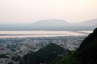
Vijayawada, formerly known as Bezawada, is the second largest city in the Indian state of Andhra Pradesh and is a part of the state's Capital Region. It is the administrative headquarters of the NTR district. It comprises NTR and part of Krishna district. Vijayawada lies on the banks of Krishna river surrounded by the hills of Eastern Ghats, known as Indrakeeladri Hills. It geographically lies on the center spot of Andhra Pradesh. The city has been described as the commercial, political, cultural and educational capital of Andhra Pradesh It is the second largest city in Andhra Pradesh with a population of 17,23,000 in 2021, estimated population of 19,91,189 in the Vijayawada Metropolitan Area. It is one of the fastest growing urban areas in India and among the top 10 fastest growing cities in the world according to Oxford Economics report.

Bhimavaram is a city and headquarters of West Godavari district of the Andhra Pradesh state of India. It is the administrative headquarters of Bhimavaram mandal. As of 2011 census, it is the most populous urban area in the district with a population of 210,000. It is one of the major pilgrimage centers in the state, which is home to Somaramam, one of the five great Pancharama Kshetras.

Nuzvid is a city in Eluru district of the Indian state of Andhra Pradesh. It serves as the administrative headquarters for Nuzvid mandal and Nuzvid revenue division.

The Sarkhej–Gandhinagar Highway, colloquially the S.G. Road or S.G. Highway, connects the city of Ahmedabad with Gandhinagar, the capital of the state of Gujarat, India. It forms the major part of NH 8C that connects Sarkhej with Chiloda near Gandhinagar. It is a major artery road for commercial and public transport and is witnessing a major construction boom along its route towards Gandhinagar.
Vuyyuru is a town in Krishna district of the Indian state of Andhra Pradesh. It is a Nagar panchayat and the headquarters of Vuyyuru Mandal. It is emerging as neighbourhood of Vijayawada, India situated 30 km away.List of Neighborhoods in Vijayawada

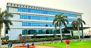
Andhra Pradesh State Road Transport Corporation (APSRTC) is the state-owned road transport corporation in the Indian state of Andhra Pradesh. Its headquarters is located at NTR Administrative Block of RTC House in Pandit Nehru bus station of Vijayawada. Many other Indian metro towns in Telangana, Tamil Nadu, Karnataka, Odisha, Yanam, Kerala, Maharashtra and Chhattisgarh are also linked with the APSRTC services.
Kotabommali is a mandal in the Srikakulam district of the Indian state of Andhra Pradesh.

Narasannapeta is a census town in Srikakulam district of the Indian state of Andhra Pradesh. It is the mandal headquarters of Narasannapeta mandal in Srikakulam revenue division. 43 villages are there under the administrative division of Narasannapeta.

Ramavarappadu is a residential hub located in the East-Central part of Vijayawada in Krishna district of the Indian state of Andhra Pradesh. It is located in Vijayawada (rural) mandal of Vijayawada revenue division. As per the G.O. No. M.S.104 (dated:23-03-2017), Municipal Administration and Urban Development Department, it became a part of Vijayawada metropolitan area.It is surrounded by Prasadampadu on the East, Gunadala on the West, Kanuru and Currency Nagar on the south.

Tadepalle is a model town in Guntur district of Indian state of Andhra Pradesh. The town is a part of Mangalagiri Tadepalle Municipal Corporation and part of Tenali revenue division. It is a major south sub urban of Vijayawada and a part of Vijayawada metropolitan area and Andhra Pradesh Capital Region. It is situated on National Highway 16 between Vijayawada and Guntur.
Vijayawada is the second-largest city in the state of Andhra Pradesh of India. It is one of the Tier-II cities and is categorized under the B-1 graded cities of India. Factors contributing to its economic growth include agricultural exports, tourism, resources, industries and transportation etc. The economy depends largely on trade and commerce, which provides entrepreneurial growth. About 70% of working people are involved in tertiary activities. According to one study, the GDP of the city in 2010 was $3 billion and is expected to grow up to $17 billion by 2025. According to another by Oxford the GDP of the city in 2018 was $5.8 billion and is expected to grow up to $21 billion by 2035.

NAD X Road, or NAD Kotha Road, is one of the major junctions and commercial centers in Visakhapatnam, India. It is named for the Naval Armament Depot. The Naval Armament Depot and (NSTL) Naval Science and Technological Laboratories is located here.

Amaravati is the capital of the Indian state of Andhra Pradesh. It is located on the banks of the river Krishna in Guntur district.

Patamata is an affluent suburban in centre part of Vijayawada, Andhra Pradesh, India. It is one of the most expensive commercial and residential locations in Vijayawada. The area contains shopping malls and jewellery shops. It has become a major transit point for traffic because it lies between Benz Circle and Auto Nagar. It falls under the 12th ward of Vijayawada Municipal Corporation and the present corporator is Sambaiah. It is an unreserved ward for women candidates.
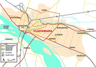
Transport in Vijayawada is the network of roads, railways, rapid transit system in the second largest city of Andhra Pradesh. The city of Vijayawada also serves as the central hub of transport and logistics within the state.
The Kanaka Durga Varadhi is a beam bridge Spanning Across Krishna River in between Mangalagiri Tadepalle Municipal Corporation and Vijayawada, Andhra Pradesh, India. It is the Third Longest Road Bridge in Andhra Pradesh, After Bridges on Godavari river, Whereas the Longest of all bridges is in Andhra Pradesh Capital Region. Its construction was followed by old barrage named Prakasam Barrage, which serves the transportation needs of Vijayawada.
The Kanakadurga Flyover is a Flyover Spanning the Krishna River and Prakasam Barrage in Vijayawada, India. It is the Longest Flyover in Andhra Pradesh as of 2022 with a Length of 2.6 kilometres (1.6 mi). It was inaugurated on 16 October 2020 by Nitin Gadkari.
The Vijayawada Municipal Corporation is in charge of the civic administration and infrastructure of the city of Vijayawada. The corporation was formed in 1981 by upgrading from municipality status. Many other neighbourhoods were later merged into the corporation limits to a total area of 61.88 km2 (23.89 sq mi), located in Krishna district. It is adjoined by the Legislative capital of Andhra Pradesh, Amaravati. It was also been part of Andhra Pradesh Capital Region. The Vijayawada Municipal Corporation is divided into 77 wards. Each ward is headed by a corporator, elected by popular vote. The corporators elect The City Mayor who is the titular head of the corporation. Its executive powers lie with the Municipal Commissioner appointed by the Government of Andhra Pradesh. The Andhra Pradesh State Election Commission monitors the municipal elections that are held in the city once in every five years. The last elections were held on 10 March 2021.
Benz Circle Flyover is a Flyover spanning the Benz Circle area in Vijayawada, India. The 2.3 kilometres (1.4 mi) long flyover is part of the expansion of National Highway 16 and National Highway 65. Planned as a two-phased project, the first phase was inaugurated on 16 October 2020 by Nitin Gadkari. The flyover is expected to be wholly completed by 2022.

