Bering Strait crossing

Last updated
North Pole view of the Bering Strait North pole map.jpeg
North Pole view of the Bering Strait

A Bering Strait crossing is a hypothetical bridge or tunnel that would span the relatively narrow and shallow Bering Strait between the Chukotka Peninsula in Russia and the Seward Peninsula in the U.S. state of Alaska. The crossing would provide a connection linking the Americas and Afro-Eurasia.

Contents

With the two Diomede Islands between the peninsulas, the Bering Strait could be spanned by a bridge or tunnel.

There have been several proposals for a Bering Strait crossing made by various individuals and media outlets. The names used for them include "The Intercontinental Peace Bridge" and "EurasiaAmerica Transport Link". [1] Tunnel names have included "TKMWorld Link", "AmerAsian Peace Tunnel" and InterBering. [2] In April 2007, Russian government officials told the press that the Russian government would back a US$65 billion plan by a consortium of companies to build a Bering Strait tunnel. [3]

History

Satellite image of Bering Strait. Cape Dezhnev, Russia, is on the left, the two Diomede Islands are in the middle, and Cape Prince of Wales, Alaska, is on the right. BeringSt-close-VE.jpg
Satellite image of Bering Strait. Cape Dezhnev, Russia, is on the left, the two Diomede Islands are in the middle, and Cape Prince of Wales, Alaska, is on the right.

19th century

The concept of an overland connection crossing the Bering Strait goes back before the 20th century. William Gilpin, first governor of the Colorado Territory, envisaged a vast "Cosmopolitan Railway" in 1890 linking the entire world through a series of railways.

Two years later, Joseph Strauss, who went on to design over 400 bridges, and then serve as the project engineer for the Golden Gate Bridge, put forward the first proposal for a Bering Strait rail bridge in his senior thesis. [4] The project was presented to the government of the Russian Empire, but it was rejected. [5]

20th century

In 1904, a syndicate of American railroad magnates proposed (through a French spokesman) a SiberianAlaskan railroad from Cape Prince of Wales in Alaska through a tunnel under the Bering Strait and across northeastern Siberia to Irkutsk via Cape Dezhnev, Verkhnekolymsk, and Yakutsk (around 5,000 km (3,100 mi) of railroad to build, plus over 3,000 km (1,900 mi) in North America). The proposal was for a 90-year lease, and exclusive mineral rights for 8 miles (13 km) each side of the right-of-way. It was debated by officials and finally turned down on March 20, 1907. [6]

Czar Nicholas II approved the American proposal in 1905 (only as a permission, not much financing from the Czar). [7] Its cost was estimated at $65 million [8] and $300 million, including all the railroads. [7] These hopes were dashed with the outbreak of the 1905 Russian Revolution followed by World War I. [9]

A Nazi plan to create a wide-gauge railroad called the Breitspurbahn was mooted to connect the cities of Europe, India, China and ultimately North America via the Bering Strait. The railroad was never built.

Interest was renewed during World War II with the completion in 194243 of the Alaska Highway, linking the remote territory of Alaska with Canada and the continental United States. In 1942, the Foreign Policy Association envisioned the highway continuing to link with Nome near the Bering Strait, linked by highway to the railhead at Irkutsk, using an alternative sea-and-air ferry service across the Bering Strait. [10] At the same time the road on the Russian side was extended by building the 2000-kilometer (1250 mi) Kolyma Highway.

In 1958, engineer Tung-Yen Lin suggested the construction of a bridge across the Bering Strait "to foster commerce and understanding between the people of the United States and the Soviet Union". [11] Ten years later he organized the Inter-Continental Peace Bridge, Inc., a non-profit institution organized to further this proposal. [11] At that time he made a feasibility study of a Bering Strait bridge and estimated the cost to be $1 billion for the 50-mile (80 km) span. [12] In 1994 he updated the cost to more than $4 billion. Like Gilpin, Lin envisioned the project as a symbol of international cooperation and unity, and dubbed the project the Intercontinental Peace Bridge. [13]

21st century

According to a report in the Beijing Times in May 2014, Chinese transport experts had proposed building a roughly 10,000-kilometer (6,200 mi) high-speed rail line from northeast China to the United States. [14] The project would include a tunnel under the Bering Strait and connect to the contiguous United States via Wales, Alaska, along the river to Fairbanks, Alaska, and along the Alaska Highway to Edmonton, Alberta, Canada.

Several American entrepreneurs have also advanced private-sector proposals, such as an Alaska-based limited-liability company InterBering founded in 2010 to lobby for a cross-straits connection, and a 2018 cryptocurrency offering to fund the construction of a tunnel. [15] [16] [17] In 2005, investor Neil Bush, younger brother of U.S. President George W. Bush and son of President George H. W. Bush, traveled abroad with Sun Myung Moon of the Unification Church as he promoted a proposal to dig a transportation corridor beneath the Bering Strait. When questioned by Mother Jones during the Republican primary campaign of his brother Jeb Bush a decade later in 2015, he denied having supported the tunnel project and said that he had traveled with Moon because he supported "efforts by faith leaders to call their flock into service to others." [18]

Strategic military concerns

Proposals to build a crossing predate the Russian invasion of Ukraine and the Russian-Ukrainian War, which started in February 2022. It is not known how those events have affected strategic concerns relating to the proposed crossing, which would facilitate access by Russia to North America. Even before the invasion, commentators on the proposed link have flagged strategic military concerns as a factor in any decision to build the crossing. [19] [20] [21]

Technical concerns

Bering Strait depth Bering Strait depth.gif
Bering Strait depth

Distance

The straight distance between Russia and Alaska is 82.5 kilometres (51.3 mi). If building bridges and using the Diomede Islands, the straight distance over water for the three parts would be 36.0 kilometres (22.4 mi), 3.8 kilometres (2.4 mi) and 36.8 kilometres (22.9 mi), in total 76.6 kilometres (47.6 mi). [22]

Depth of water

The depth of the water is a minor problem, as the strait is no deeper than 55 meters (180 ft), [13] comparable to the English Channel. The tides and currents in the area are not severe. [11]

Restrictions on construction work

The route is just south of the Arctic Circle, and the location has long, dark winters and extreme weather, including average winter lows of −20 °C (−4 °F) and temperatures approaching −50 °C (−58 °F) in cold snaps. This would mean that construction work would likely be restricted to five months of the year, around May to September, and centered during summer. [13]

Exposed steel

The weather also poses challenges to exposed steel.[ clarification needed ] [13] In Lin's design, concrete covers all structures, to simplify maintenance and to offer additional stiffening. [13]

Ice floes

Although there are no icebergs in the Bering Strait, ice floes up to 1.8 meters (6 ft) thick are in constant motion during certain seasons, which could produce forces on the order of 44 meganewtons (9,900,000 pounds-force ; 4,500 tonnes-force ) on a pier. [11]

Tundra in surrounding regions

Roads on either side of the strait would likely have to cross tundra, requiring either an unpaved road or some way to avoid the effects of permafrost.

Likely route and expenses

Place for the bridge, showing the Siberian ghost town of Naukan as its western terminus. BeringBridge.jpg
Place for the bridge, showing the Siberian ghost town of Naukan as its western terminus.

Bridge option

If the crossing is chosen as a bridge, it would probably connect Wales, Alaska, to a location south of Uelen. The bridge would also likely be divided by the Diomede Islands, which are at the middle of the Bering Strait.

In 1994, Lin estimated the cost of a bridge to be "a few billion" dollars. [13] The roads and railways on each side were estimated to cost $50 billion. [13] Lin contrasted this cost to petroleum resources "worth trillions". [13] Discovery Channel's Extreme Engineering estimates the cost of a highway, electrified double-track high-speed rail, and pipelines at $105 billion (in 2007 US dollars), five times the original cost of the 1994 50-kilometer (31 mi) Channel Tunnel. [23]

Connections to the rest of the world

This excludes the cost of new roads and railways to reach the bridge. Aside from the technical challenges of building two 40-kilometer (25 mi) bridges or a more than 80-kilometer (50 mi) tunnel across the strait, another major challenge is that, as of 2022, there is nothing on either side of the Bering Strait to connect the bridge to.

Russian side

The Russian side of the strait, in particular, is severely lacking in infrastructure. No railways exist for over 2,800 kilometers (1,700 mi) in any direction from the strait. [24]

The nearest major connecting highway is the M56 Kolyma Highway, which is currently unpaved and around 2,000 kilometers (1,200 mi) from the strait. [25] However, by 2042, the Anadyr Highway is expected to be completed connecting Ola and Anadyr, which is only about 600 kilometers (370 mi) from the strait. [26]

U.S. side

On the U.S. side, an estimated 1,200 kilometers (750 mi) of highways or railroads would have to be built around Norton Sound, through a pass along the Unalakleet River, and along the Yukon River to connect to Manley Hot Springs Road in other words, a route similar to that of the Iditarod Trail Race. A project to connect Nome, 100 miles (160 km) from the strait, to the rest of Alaska by a paved highway (part of Alaska Route 2) has been proposed by the Alaskan state government, although the very high cost ($2.3 to $2.7 billion, about $5 million per mile, or $3 million per kilometer) has so far prevented construction. [27]

In 2016, the Alaskan road network was extended westwards by 50 miles (80 km) to Tanana, 460 miles (740 km) from the strait, by building a fairly simple road. The Alaska Department of Transportation & Public Facilities project was supported by local indigenous groups such as the Tanana Tribal Council. [28]

Track gauge

Russia uses a different track gauge from the US and Canada Rail gauge world.svg
Russia uses a different track gauge from the US and Canada

Another complicating factor is the different track gauges in use. Mainline rail in the US, Canada, China, and the Koreas uses standard gauge of 1435 millimeters. Russia uses the slightly broader Russian gauge of 1520 mm.
Solutions to this break of gauge include:

  • To have all cargo in containers, which are fairly easily reloaded from one train to another. This is used on the increasingly popular China–Europe rail freight route, which has two breaks of gauge. It is possible to transfer a 60-container train in one hour.
  • Another solution is variable gauge axles for locomotives and rolling stock, such as those made by Talgo. A gauge changer modifies the gauge of the wheels while the train traverses the GC equipment at a speed of 15 km/h (4.2 m/s), which is about 4 seconds per railcar. This is faster than is possible with the transfer of ISO containers.
Map showing the proximity of Chukchi Peninsula in Russia to Seward Peninsula in the United States. The Diomede Islands between the two are not shown. Berengia - present day.png
Map showing the proximity of Chukchi Peninsula in Russia to Seward Peninsula in the United States. The Diomede Islands between the two are not shown.

The TKMWorld Link(Russian: ТрансКонтинентальная магистраль, English: Transcontinental Railway), also called ICL-World Link (Intercontinental link), was a planned 6,000-kilometer link between Siberia and Alaska to deliver oil, natural gas, electricity, and rail passengers to the United States from Russia. Proposed in 2007, the plan included provisions to build a 103-kilometer (64 mi) tunnel under the Bering Strait, which, if built, would become the longest tunnel in the world, [29] surpassing the 60-kilometer (37 mi) Line 3 (Guangzhou Metro) tunnel. The tunnel would be part of a railway joining Yakutsk, the capital of the Russian republic of Yakutia, and Komsomolsk-on-Amur, in the Russian Far East, with the western coast of Alaska. [30] The Bering Strait tunnel was estimated to cost between $10 billion and $12 billion, while the entire project was estimated to cost $65 billion. [29]

In 2008, Russian Prime Minister Vladimir Putin approved the plan to build a railway to the Bering Strait area, as a part of the development plan to run until 2030. The more than 100-kilometer (60 mi) tunnel would run under the Bering Strait between Chukotka, in the Russian far east, and Alaska. [31] The cost was estimated as $66 billion. [32]

In late August 2011, at a conference in Yakutsk in eastern Russia, the plan was backed by some of President Dmitry Medvedev's top officials, including Aleksandr Levinthal, the deputy federal representative for the Russian Far East. [30] It would be a faster, safer, and cheaper way to move freight around the world than container ships, supporters of the idea believed. [30] They estimated it could carry about 3% of global freight and make about $7 billion a year. [30] Shortly after, the Russian government approved the construction of the $65 billion Siberia-Alaska rail and tunnel across the Bering Strait. [31]

Other observers doubt that this will be cheaper than container ships, bearing in mind that the cost for transport from China to Europe by rail is higher than by container ship (except for expensive cargo where lead time is important). [33]

In 2013, the Amur Yakutsk Mainline connecting the Yakutsk railway (2,800 km or 1,700 mi from the strait) with the Trans-Siberian Railway was completed. However, this railway is meant for freight and is too curvy for high-speed passenger trains. Future projects include the Lena–Kamchatka Mainline  [ ru ] and Kolyma–Anadyr highway. The Kolyma–Anadyr highway has started construction, but will be a narrow gravel road.

USCanadaRussiaChina railway

In 2014, China was considering construction of a US-Canada-Russia-China 350 km/h (220 mph) bullet train that would include a 200-kilometer (120 mi) undersea tunnel crossing the Bering Strait and would allow passengers to travel between the United States and China in about two days. [34] [35]

Although the press was skeptical of the project, China's state-run China Daily claimed that China possessed the necessary technology. [36] It was unknown who was expected to pay for the construction, although China had in other projects offered to build and finance them, and expected the money back in the end through fees or rents.

Trans-Eurasian Belt Development

In 2015, another possible collaboration between China and Russia was reported, part of the Trans-Eurasian Belt Development, a transportation corridor across Siberia that would also include a road bridge with gas and oil pipelines between the easternmost point of Siberia and the westernmost point of Alaska. It would link London and New York by rail and superhighway via Russia if it were to go ahead. [37]

China's Belt and Road Initiative has similar plans, so the project would work in parallel for both countries. [38]

See also

Related Research Articles

<span class="mw-page-title-main">Transport in Russia</span> Overview of the transport in Russia

The transport network of the Russian Federation is one of the world's most extensive transport networks. The national web of roads, railways and airways stretches almost 7,700 km (4,800 mi) from Kaliningrad in the west to the Kamchatka Peninsula in the east, and major cities such as Moscow and Saint Petersburg are served by extensive rapid transit systems.

<span class="mw-page-title-main">Bering Strait</span> Strait between Asia and North America

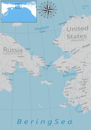
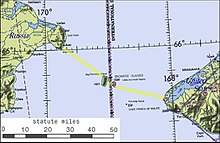
The Bering Strait is a strait between the Pacific and Arctic oceans, separating the Chukchi Peninsula of the Russian Far East from the Seward Peninsula of Alaska. The present Russia-United States maritime boundary is at 168° 58' 37" W longitude, slightly south of the Arctic Circle at about 65° 40' N latitude. The Strait is named after Vitus Bering, a Danish explorer in the service of the Russian Empire.

<span class="mw-page-title-main">Trans-Siberian Railway</span> Railway network spanning Russia

The Trans-Siberian Railway, historically known as the Great Siberian Route and often shortened to Transsib, is a large railway system that connects European Russia to the Russian Far East. Spanning a length of over 9,289 kilometers, it is the longest railway line in the world. It runs from the city of Moscow in the west to the city of Vladivostok in the east.

<span class="mw-page-title-main">Baikal–Amur Mainline</span> Russian rail road route

The Baikal–Amur Mainline is a 1,520 mm broad-gauge railway line in Russia. Traversing Eastern Siberia and the Russian Far East, the 4,324 km (2,687 mi)-long BAM runs about 610 to 770 km north of and parallel to the Trans-Siberian Railway.

<span class="mw-page-title-main">Chukotka Autonomous Okrug</span> First-level administrative division of Russia

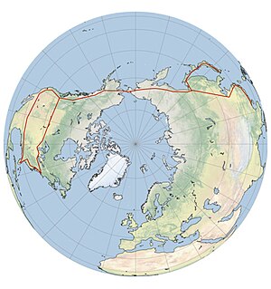
Chukotka, officially the Chukotka Autonomous Okrug, is the easternmost federal subject of Russia. It is an autonomous okrug situated in the Russian Far East, and shares a border with the Republic of Sakha to the west, Magadan Oblast to the south-west, and Kamchatka Krai to the south, as well as a maritime border on the Bering Strait with the U.S. state of Alaska to the east. Anadyr is the largest town and the capital, and the easternmost settlement to have town status in Russia.

Semyon Ivanovich Dezhnyov was a Russian explorer of Siberia and the first European to sail through the Bering Strait, 80 years before Vitus Bering did. In 1648 he sailed from the Kolyma River on the Arctic Ocean to the Anadyr River on the Pacific. His exploit was forgotten for almost a hundred years and Bering is usually given credit for discovering the strait that bears his name.

<span class="mw-page-title-main">Eurasian Land Bridge</span> Rail route between East Asia and Europe

The Eurasian Land Bridge, sometimes called the New Silk Road, is the rail transport route for moving freight and passengers overland between Pacific seaports in the Russian Far East and China and seaports in Europe. The route, a transcontinental railroad and rail land bridge, currently comprises the Trans-Siberian Railway, which runs through Russia and is sometimes called the Northern East-West Corridor, and the New Eurasian Land Bridge or Second Eurasian Continental Bridge, running through China and Kazakhstan. As of November 2007, about one percent of the $600 billion in goods shipped from Asia to Europe each year were delivered by inland transport routes.

<span class="mw-page-title-main">Seward Peninsula</span> Peninsula on the western coast of Alaska

The Seward Peninsula is a large peninsula on the western coast of the U.S. state of Alaska whose westernmost point is Cape Prince of Wales. The peninsula projects about 200 mi (320 km) into the Bering Sea between Norton Sound, the Bering Strait, the Chukchi Sea, and Kotzebue Sound, just below the Arctic Circle. The entire peninsula is about 210 mi (330 km) long and 90–140 mi (145–225 km) wide. Like Seward, Alaska, it was named after William H. Seward, the United States Secretary of State who fought for the U.S. purchase of Alaska.

<span class="mw-page-title-main">R504 Kolyma Highway</span> Road in eastern Russia

The R504 Kolyma Highway, part of the M56 route, is a road through the Russian Far East. It connects Magadan with the town of Nizhny Bestyakh, located on the eastern bank of the Lena River, opposite of Yakutsk. At Nizhny Bestyakh the Kolyma Highway connects to the Lena Highway.

Transportation in North America is performed through a varied transportation system, whose quality ranges from being on par with a high-quality European motorway to an unpaved gravelled back road that can extend hundreds of miles. There is also an extensive transcontinental freight rail network, but passenger railway ridership is lower than in Europe and Asia.

A fixed link or fixed crossing is a permanent, unbroken road or rail connection across water that uses some combination of bridges, tunnels, and causeways and does not involve intermittent connections such as drawbridges or ferries. A bridge–tunnel combination is commonly used for major fixed links.

<span class="mw-page-title-main">A360 Lena Highway</span> Road in Russia

A360 Lena Highway or The Amur-Yakutsk Highway is a federal highway in Sakha (Yakutia) in Russia, connecting Yakutsk with the Trans-Siberian Railway corridor near Skovorodino. The road was built in stages between 1925 and 1964.

<span class="mw-page-title-main">Japan–Korea Undersea Tunnel</span> Proposed tunnel connecting Japan and Korea

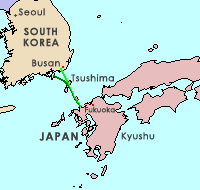
The Japan–Korea Undersea Tunnel, or Korea–Japan Undersea Tunnel, is a proposed tunnel project to connect Japan with South Korea via an undersea tunnel crossing the Korea Strait that would use the strait islands of Iki and Tsushima, a straight-line distance of approximately 128 kilometers (80 mi) at its shortest.

<span class="mw-page-title-main">Siberian River Routes</span> Main ways of communication in the Russian Siberia before the 1730s

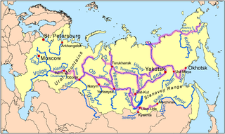
Siberian River Routes were the main ways of communication in Russian Siberia before the 1730s, when roads began to be built. The rivers were also of primary importance in the process of Russian conquest and exploration of vast Siberian territories eastwards. Since the three great Siberian rivers, the Ob, the Yenisey, and the Lena all flow into the Arctic Ocean, the aim was to find parts or branches of these rivers that flow approximately east-west and find short portages between them. Since Siberia is relatively flat, portages were usually short. Despite resistance from the Siberian tribes, Russian Cossacks were able to expand from the Urals to the Pacific in only 57 years (1582-1639). These river routes were crucial in the first years of the Siberian fur trade as the furs were easier to transport over water than land. The rivers connected the major fur gathering centers and provided for relatively quick transport between them.

<span class="mw-page-title-main">Amur–Yakutsk Mainline</span> Partially complete Russian railway

The Amur–Yakutsk Mainline, abbreviated to AYaM, is a partially complete railway in eastern Russia, linking the Trans–Siberian Railway and Baikal–Amur Mainline with the Sakha Republic.

Cross-sea traffic ways are vehicle or railroad traffic ways across the sea. Such traffic ways could include bridges or tunnels.

<span class="mw-page-title-main">Sakhalin Tunnel</span>

The Sakhalin Tunnel is an incomplete and currently indefinitely postponed construction project, which after completion would have connected the island of Sakhalin with mainland Russia via a tunnel of approximately 10 kilometres (6 mi) under the Nevelskoy Strait.

<span class="mw-page-title-main">Sakhalin–Hokkaido Tunnel</span> Proposed tunnel between Russia and Japan

The Sakhalin–Hokkaido Tunnel is a proposed connection to link the Russian island of Sakhalin with the Japanese island of Hokkaido. Cost estimates by Russia in the year 2000 put the project to span the 45-kilometre (28-mile) strait at $50 billion.

<span class="mw-page-title-main">Bohai Strait tunnel project</span> Proposed Eastern China underpass

The Bohai Strait Tunnel or Dalian-Yantai Tunnel is a proposed undersea tunnel construction project across the Bohai Strait to connect Dalian on the Liaodong Peninsula with Yantai on the Shandong Peninsula. The official name for the project is Bohai Strait Cross-Sea Corridor.

<span class="mw-page-title-main">Baron Loicq de Lobel</span> French engineer

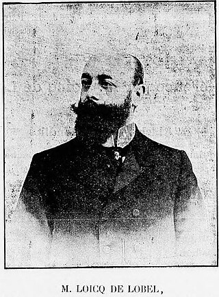
Léon Loicq de Lobel, sometimes referred to as Baron Loicq de Lobel, was a French engineer and aristocrat, primarily known for his briefly popular proposal in 1906 to build a bridge-and-tunnel link between Siberia and Alaska.

References

  1. A Transcontinental Eurasia-America Transport Link via the Bering Strait Archived 2007-11-14 at the Wayback Machine , at the 1st International Conference "Megaprojects of the Russian East"
  2. "INTERBERING".
  3. "Russia wants a rail link to North America". Der Spiegel. April 20, 2007.
  4. Kevin Starr. Endangered Dreams: The Great Depression in California, 330. Oxford University Press, 1996. ISBN   0-19-510080-8
  5. An excerpt from memoirs Archived 2007-09-28 at the Wayback Machine of the Russian Empire Minister of Land Forces Aleksandr Rediger (in Russian)
  6. Theodore Shabad and Victor L. Mote: Gateway to Siberian Resources (The BAM) pp. 70-71 (Halstead Press/John Wiley, New York, 1977) ISBN   0-470-99040-6
  7. 1 2 "Czar Authorizes American Syndicate to Begin Work". The New York Times . August 2, 1906. Retrieved 2009-07-07. The Czar of Russia has issued an order authorizing the American syndicate, represented by Baron Loicq de Lobel, to begin work on the TransSiberian-Alaska ...
  8. Burr, William H. (January 1907). "Around the World by Rail". Locomotive Engineers Journal. 41. Brotherhood of Locomotive Engineers: 108–111.
  9. Halpin, Tony (April 20, 2007). "Russia plans $65bn tunnel to America". The Times. London. Retrieved 2009-11-02.
  10. Special to THE NEW YORK TIMES (July 20, 1942). "AIRWAY TO RUSSIA VIA ALASKA URGED; Foreign Policy Association Also Favors Northern Sea Route and Bering Link". The New York Times. p. 3. Retrieved 2009-10-25.
  11. 1 2 3 4 Troitsky, M. S. (1994). "1.10.4 Bering Strait Bridge Project". Planning and design of bridges (illustrated ed.). John Wiley and Sons. pp. 39–41. ISBN   978-0-471-02853-6.
  12. "Engineer feels Bering Strait Bridge Possible". The Bulletin. April 23, 1969. p. 12. Retrieved 2009-10-11.[ permanent dead link ]
  13. 1 2 3 4 5 6 7 8 Pope, Gregory (April 1994). "Last Great Engineering Challenge: Alaska-Siberia Bridge". Popular Mechanics. 171 (4). Hearst Magazines: 56–58. ISSN   0032-4558.
  14. Tharoor, Ishaan (May 9, 2014). "China may build an undersea train to America". The Washington Post .
  15. Shirk, Adrian (1 July 2015). "A Superhighway Across the Bering Strait". The Atlantic. Archived from the original on October 13, 2018. Retrieved 4 February 2019.
  16. About InterBering: "Our expertise includes the integration of information and management processes for the organization, financing and construction of an interhemispheric Bering Strait tunnel and joining the railways of two continents, North America and Asia."
  17. "Beringia". Beringia.io. Archived from the original on 26 August 2018. Retrieved 4 February 2019.
  18. Murphy, Tim (6 January 2015). "Here Is a Crazy Story About Jeb Bush's Brother and a $400 Billion Tunnel to Russia That Wasn't Meant to Be". Mother Jones. Retrieved 4 February 2019.
  19. Adrian Shirk, "A Superhighway Across the Bering Strait", The Atlantic, 1 July 2015: "The issue left unaddressed in both my conversations with Cooper and Soloview is that none of this would be possible unless current diplomatic tensions are resolved..."
  20. Louis P. Bergeron, "The Bering Strait: Choke Point of the Future?", Second Line of Defense, 19 November 2015: "However, the geopolitics of the strait and the Arctic have turned frosty again since Russia’s involvement in Ukraine and now in Syria; the Bering Strait again has a front row seat to a declining Great Power relationship between the United States and Russia."
  21. Riccardo Rossi, "The Bering Strait, an area of Russian-US geostrategic interest" Geopolitical Report ISSN 2785-2598 Volume 16 Issue 1, SpecialEurAsia, 7 February, 2022: "This concentration of interests has led Washington to identify the following political-strategic priorities in the Bering Strait: to ensure the defence of the State of Alaska, to preserve the freedom of navigation in the strait, to exploit the fossil resources present in the Chukchi Sea and to enhance its territory near the Bering Sea as a base to launch possible air-naval operations in the North Pacific Area."
  22. "Google Maps".
  23. "Discovery Channel's Extreme Engineering". Archived from the original on 2007-10-12. Retrieved 2007-09-21.
  24. "Trip from Russia to USA may take one hour soon". 2008-04-08. Retrieved 2018-07-06.
  25. "Google Earth". earth.google.com. Retrieved 2017-12-05.
  26. "Project to build road from Kolyma to Anadyr drawn up". TASS (in Russian). 2012-06-23. Retrieved 2017-12-05.
  27. COCKERHAM, SEAN (January 27, 2010). "Nome road could cost $2.7 billion". Anchorage Daily News. Retrieved 18 May 2015.
  28. "Tanana Road opens". Alaska Public Media. 5 September 2016. Retrieved 4 February 2019.
  29. 1 2 Humber, Yuriy; Bradley Cook (April 18, 2007). "Russia Plans World's Longest Tunnel, a Link to Alaska". Bloomberg. Bloomberg. Retrieved 2 October 2013.
  30. 1 2 3 4 "Report: Tunnel linking US to Russia gains support". NBC News. 20 August 2011. Retrieved 20 August 2011.
  31. 1 2 "Russia Green Lights $65 Billion Siberia-Alaska Rail and Tunnel to Bridge the Bering Strait!". 23 August 2011. Retrieved 23 August 2011.
  32. Smith, Nicola; Hutchins, Chris (2008-03-30). "Bridgebuilding Vladimir Putin wants tunnel to US". The Times. London. Retrieved 2010-04-26.
  33. Logistics concept for the Chinese growth market Archived 2014-05-12 at the Wayback Machine (Deutsche Bahn, March 2014)
  34. Tharoor, Ishaan (2014-05-09). "China may build an undersea train to America". The Washington Post . Retrieved 2014-05-14.
  35. Politi, Daniel (2014-05-10). "Report: China Mulls Construction of a High Speed Train to the U.S." Slate. Retrieved 2014-05-14.
  36. "China mulls high-speed train to US: report". China Daily. 2014-05-08. Retrieved 2014-05-14.
  37. Stone, Jon (25 March 2015). "Russia unveils plans for high speed railway and superhighway to connect Europe and America". The Independent. Retrieved 2015-03-15.
  38. "Russian, China's trans-Asia programs complementary: railway chief". Archived from the original on 2015-08-05. Retrieved 2015-08-02.

Further reading

65°47′N169°01′W / 65.783°N 169.017°W / 65.783; -169.017