Route 18 is a 42.8-mile-long (68.9 km) state highway in the central part of the US state of New Jersey. It begins at an intersection with Route 138 in Wall Township, Monmouth County and ends at Interstate 287 (I-287) in Piscataway Township, Middlesex County. Route 18 is a major route through central New Jersey that connects the Jersey Shore to the Raritan Valley region, connecting the county seats of Monmouth (Freehold) and Middlesex respectively. The route runs through Ocean Township, Marlboro Township, East Brunswick, and is the main thoroughfare for Rutgers University. Much of the route is a freeway. The remainder of the route is an arterial road with traffic lights in the East Brunswick and Old Bridge areas, and a boulevard in the remainder of Piscataway. Route 18 was designated in 1939 as a proposed freeway from Old Bridge to Eatontown. The section west of Old Bridge was formerly designated as part Route S28, a prefixed spur of State Highway Route 28 from Middlesex to Matawan. The designation, assigned in the 1927 renumbering, remained until a second renumbering in 1953. At that point, Route S28 was redesignated as Route 18, though the section from Old Bridge to Matawan was signed as TEMP 18, as this section would be decommissioned when the Route 18 freeway was built.

Route 70 is a state highway located in the U.S. state of New Jersey. It extends 59.84 mi (96.30 km) from an interchange with Route 38 in Pennsauken Township, Camden County, east to an intersection with Route 34 and Route 35 in Wall Township, Monmouth County. Route 70 cuts across the middle of the state as a two-lane highway through the Pine Barrens in Burlington and Ocean counties. A popular truck route, it provides access between Philadelphia and the surrounding Delaware Valley metropolitan area and the Jersey Shore resorts, particularly Long Beach Island by way of Route 72. It is also a congested commercial route within Philadelphia's New Jersey suburbs. The western section in Cherry Hill and Marlton is a four- to eight-lane divided highway that serves as a major suburban arterial and is locally known as Marlton Pike. The eastern section in Monmouth and Ocean counties is also a multilane divided highway that runs through suburban areas. Route 70 is officially known as the John Davison Rockefeller Memorial Highway its entire length in honor of John Davison Rockefeller.

Route 33 is a state highway in the central part of the US state of New Jersey. The highway extends 42.03 miles (67.64 km), from an interchange with U.S. Route 1 (US 1) in Trenton, Mercer County, east to an intersection with Route 71 in Neptune, Monmouth County. Route 33 is a major route through central New Jersey, as it runs from the greater state capital area in the Delaware Valley region, through a mixture of farmland, housing, and commercial developments in the lower Raritan Valley region, en route to the greater Asbury Park area on the Jersey Shore. The route traverses through historic towns such as Hightstown, Monroe, Manalapan, Freehold, and Tinton Falls. There are several intersections on Route 33 with future developments.

Route 42 is a state highway in the U.S. state of New Jersey within the Camden area. It runs 14.28 mi (22.98 km) from an intersection with U.S. Route 322 and County Route 536 Spur in Monroe Township, Gloucester County, to an intersection with Interstate 76 (I-76) and I-295 in Bellmawr, Camden County. The southern portion of Route 42 is an four-lane divided highway and one of several highways comprising the Black Horse Pike, a road that runs from Camden to Atlantic City. The northern portion is part of a six- to eight-lane freeway referred to locally as the North–South Freeway that connects the Atlantic City Expressway to the Benjamin Franklin Bridge. Major junctions along the route include the Atlantic City Expressway and the southern terminus of Route 168 in Turnersville, Route 168 in Blackwood, and Route 41 and Route 55 in Deptford Township.
Route 52 is a state highway in the southern part of the U.S. state of New Jersey. The highway runs 2.74 mi (4.41 km) from 9th Street in Ocean City, Cape May County north to U.S. Route 9 in Somers Point, Atlantic County. It is composed mostly of a series of four-lane divided bridges over Great Egg Harbor Bay from Ocean City to Somers Point known as the Howard S. Stainton Memorial Causeway, also known as the Ninth Street Bridge. The remainder of the route is a surface road called MacArthur Boulevard that runs from the causeway to U.S. Route 9. This section of the route formerly included the Somers Point Circle, now a traffic light, where Route 52 intersects County Route 559 and County Route 585.

Route 72 is a state highway in the U.S. state of New Jersey. It runs 28.74 mi (46.25 km) from the Four Mile Circle with Route 70 in Woodland Township in Burlington County to County Route 607 in Ship Bottom on Long Beach Island in Ocean County. Route 72 travels through the Pine Barrens as a two-lane undivided road. After an interchange with the Garden State Parkway, the route becomes a four- to six-lane divided highway through built-up areas of Manhawkin and crosses the Manahawkin Bay via the Manahawkin Bay Bridge onto Long Beach Island.

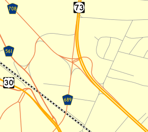
Route 73 is a state highway in the southern part of the U.S. state of New Jersey. It runs 34.64 mi (55.75 km) as an outer bypass of the Camden area from an intersection with U.S. Route 322 (US 322) in Folsom, Atlantic County, north to the Tacony–Palmyra Bridge in Palmyra, Burlington County, where the road continues into Philadelphia, Pennsylvania, as Pennsylvania Route 73. South of the interchange with the Atlantic City Expressway in Winslow Township, Camden County, Route 73 is a two-lane undivided county-maintained road and is signed as County Route 561 Spur, a spur of CR 561. North of the Atlantic City Expressway, the route is maintained by the New Jersey Department of Transportation and is mostly four lanes, with the portion north of the CR 561 concurrency a divided highway. North of the US 30 interchange near Berlin, Route 73 runs through suburban areas of the Delaware Valley metropolitan area, intersecting Route 70 in Marlton, the New Jersey Turnpike and Interstate 295 (I-295) in Mount Laurel Township, Route 38 and Route 41 in Maple Shade Township, Route 90 in Cinnaminson Township, and US 130 in Pennsauken Township.

Route 133 is a 4.42-mile-long (7.11 km) freeway located entirely in East Windsor Township, Mercer County, New Jersey in the United States. The route runs as a four-lane bypass of Hightstown from County Route 571 (CR 571) at Windsor Center Drive to the New Jersey Turnpike / Interstate 95 (I-95) at exit 8. Originally, Route 133 did not have any direct connections to any other freeways until a new Turnpike interchange opened in January 2013.

Route 83 is a state highway in the U.S. state of New Jersey. It is completely within Dennis Township, New Jersey, running 3.81 mi (6.13 km) from an intersection with Route 47 east to an intersection with U.S. Route 9 (US 9). The route, which passes through woodland and some residential development, is also known as the Trooper Bertram T. Zimmerman III Memorial Highway in honor of a New Jersey State Police officer who was killed along Route 83 in 2004 while responding to an armed robbery.

Route 139 is a state highway in Jersey City, New Jersey in the United States that heads east from the Pulaski Skyway over Tonnele Circle to the state line with New Jersey and New York in the Holland Tunnel, which is under the Hudson River, to New York City. The western portion of the route is a two level highway that is charted by the New Jersey Department of Transportation (NJDOT) as two separate roadways: The 1.45-mile (2.33 km) lower roadway (Route 139) between U.S. Route 1/9 (US 1/9) over Tonnele Circle and Interstate 78 (I-78) at Jersey Avenue, and the 0.83-mile (1.34 km) upper roadway running from County Route 501 and ending where it joins the lower highway as part of the 12th Street Viaduct, which ends at Jersey Avenue. The lower roadway is listed on the federal and NJ state registers of historic places since 2005. The eastern 1.32 miles (2.12 km) of the route includes the Holland Tunnel approach that runs concurrent with Interstate 78 on the one-way pair of 12th Street eastbound and 14th Street westbound. Including the concurrency, the total length of Route 139 is 2.77 miles (4.46 km).

The Pulaski Skyway is a four-lane bridge-causeway in the northeastern part of the U.S. state of New Jersey, carrying an expressway designated U.S. Route 1/9 (US 1/9) for most of its length. The structure has a total length of 3.502 miles (5.636 km). Its longest bridge spans 550 feet (168 m). Traveling between Newark and Jersey City, the roadway crosses the Passaic and Hackensack rivers, Kearny Point, the peninsula between them, and the New Jersey Meadowlands.
The Tonnele Circle is an intersection in Jersey City, New Jersey, United States. It is named after Tonnele ["TUN-uh-lee"] Avenue, the north–south road that runs through it.

U.S. Route 1/9 Truck is a United States Numbered Highway in the northern part of New Jersey that stretches 4.11 miles (6.61 km) from the eastern edge of Newark to the Tonnele Circle in Jersey City. It is the alternate route for US 1/9 that trucks must use because they are prohibited from using the Pulaski Skyway, which carries the main routes of US 1/9. It also serves traffic accessing the New Jersey Turnpike, Route 440, and Route 7. The route is a four- to six-lane road its entire length, with portions of it being a divided highway that runs through urban areas. From its south end to about halfway through Kearny, US 1/9 Truck is a freeway, with access to other roads controlled by interchanges.

County Route 561 is a county highway in the U.S. state of New Jersey. The highway extends 50.95 miles (82.00 km) from New York Road in Galloway Township to Federal Street in Camden.

County Route 549 is a county highway in the U.S. state of New Jersey. The highway extends 17.82 miles (28.68 km) from Main Street at County Route 527 in Toms River to County Route 547 at Monmouth CR 21 in Howell. The highway has the distinction of being the only 500-series route left with two separate spur routes.
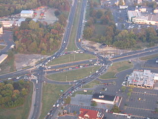
The Marlton Circle was a traffic circle in the Marlton section of Evesham Township, New Jersey, located at the intersection of Route 70 and Route 73. The highways connecting through the circle provided access to drivers navigating to and between the New Jersey Turnpike, the Tacony-Palmyra Bridge and points on the Jersey Shore.

U.S. Route 30 is a U.S. highway running from Astoria, Oregon east to Atlantic City, New Jersey. In the U.S. state of New Jersey, US 30 runs 58.26 miles (93.76 km) from the Benjamin Franklin Bridge at the Delaware River in Camden, Camden County, while concurrent with Interstate 676 (I-676), southeast to Virginia Avenue in Atlantic City, Atlantic County. Most of the route in New Jersey is known as the White Horse Pike and is four lanes wide. The road runs through mostly developed areas in Camden County, with surroundings becoming more rural as the road approaches Atlantic County. US 30 runs through several towns including Collingswood, Berlin, Hammonton, Egg Harbor City, and Absecon.

Transportation in New Jersey utilizes a combination of road, rail, air, and water modes. New Jersey is situated between Philadelphia and New York City, two major metropolitan centers of the Boston-Washington megalopolis, making it a regional corridor for transportation. As a result, New Jersey's freeways carry high volumes of interstate traffic and products. The main thoroughfare for long distance travel is the New Jersey Turnpike, the nation's fifth-busiest toll road. The Garden State Parkway connects the state's densely populated north to its southern shore region. New Jersey has the 4th smallest area of U.S. states, but its population density of 1,196 persons per sq. mi causes congestion to be a major issue for motorists.

The Winant Avenue Bridge is a vehicular movable bridge spanning the Hackensack River in Bergen County, New Jersey 14 miles (23 km) from its mouth at Newark Bay. Built in 1934, it is also known as the Route 46 Hackensack River Bridge and S46 Bridge, it carries U.S. Route 46 (US 46) in Little Ferry and Ridgefield Park. Owned and operated by the New Jersey Department of Transportation (NJDOT), the double leaf bascule bridge is located on a navigable reach. While there have been no requests since 1978, the Code of Federal Regulations last amended in 1999 requires 24-hour notice to be opened. The bridge has been minimally altered since its construction and is eligible for individual listing on the National Register of Historic Places (NRHP).