Bethel, New York

Last updated

Bethel, New York
1969 Woodstock Monument.jpg
1969 Woodstock Monument
Bethel, NY Seal.png
Motto: 
Home of the 1969 Original Woodstock Festival
Bethel-ny.png
U.S. Census map
Sullivan County New York incorporated and unincorporated areas Bethel highlighted.svg
Coordinates: 41°41′27″N74°50′30″W / 41.69083°N 74.84167°W / 41.69083; -74.84167
CountryUnited States
State New York
County Sullivan
Area
[1]
  Total89.96 sq mi (232.99 km2)
  Land85.27 sq mi (220.84 km2)
  Water4.69 sq mi (12.15 km2)
Elevation
1,322 ft (403 m)
Population
 (2020)
  Total3,959
Time zone UTC-5 (Eastern (EST))
  Summer (DST) UTC-4 (EDT)
ZIP Code
12720
Area code 845
FIPS code 36-06310
GNIS feature ID0978730
Website townofbethelny.us

Bethel is a town in Sullivan County, New York, United States. The population was estimated at 3,959 in 2020. [2] The town received worldwide attention after it served as the location of Woodstock in 1969, which was originally planned for Wallkill, New York, but was relocated to Bethel after Wallkill withdrew.

Contents

History

The first European settlers arrived circa 1795 near the present communities of Bethel and White Lake. The town of Bethel was established in 1809 from the town of Lumberland. It was named after Bethel.

By the middle of the 19th century, a tourist industry began to grow. Bethel was home to numerous hotels that were part of the "Borscht Belt" and numerous sleepaway camps for most of the 20th century, including Camp Ma-Ho-Ge, Camp Chipinaw, and Camp Ranger all on Silver Lake. In 1961, Son of Sam mass murderer David Berkowitz was a camper at a now defunct summer camp in Bethel. Berkowitz left the camp after a suspicious fire occurred in his cabin.

Geography

According to the United States Census Bureau, the town has a total area of 90.0 square miles (233 km2), of which 85.4 square miles (221 km2) is land and 4.6 square miles (12 km2) (5.13%) is water. One of the most attractive features of Bethel is its access to numerous lakes, all within a five-minute drive of each other. They include White Lake, its northern portion known as Kauneonga Lake, Silver Lake, and Lake Superior, which is part of the state park with the same name.

The Town of Bethel, which is primarily rural in character, was part of the old Borscht Belt Catskills resort area. Although some bungalow colonies continue to exist, catering to a largely Orthodox Jewish clientele during the summer, most of the old resorts which had their heyday from the 1930s to the early 1970s have long since closed.

Demographics

Historical population
CensusPop.Note
1820 1,096
1830 1,2039.8%
1840 1,48323.3%
1850 2,08740.7%
1860 2,85436.8%
1870 2,736−4.1%
1880 2,562−6.4%
1890 2,158−15.8%
1900 2,2484.2%
1910 2,164−3.7%
1920 1,849−14.6%
1930 1,799−2.7%
1940 2,32129.0%
1950 2,3511.3%
1960 2,3660.6%
1970 2,76316.8%
1980 3,33520.7%
1990 3,69310.7%
2000 4,36218.1%
2010 4,255−2.5%
2020 3,959−7.0%
U.S. Decennial Census [3] [4]

At the time of the census [5] of 2000, there were 4,362 people, 1,649 households, and 1,101 families residing in the town. The population density was 51.1 inhabitants per square mile (19.7/km2). There were 3,641 housing units at an average density of 42.6 per square mile (16.4/km2). The racial makeup of the town in 2000 was 90.35% White, 11.28% Latin American or Latino of any race, 4.61% African American, 2.80% other races, 1.40% two or more races, 0.50% Asian, 0.18% Native American, and 0.16% Pacific Islander.

There were 1,649 households, out of which 54.2% were married couples living together. 27.1% had children under the age of 18 living with them, 33.2% were non-families, 27.3% of all households were made up of individuals, and 12.0% had someone living alone who was 65 years of age or older. 7.9% had a female householder with no husband present. The average household size was 2.45 and the average family size was 2.95.

The ages of the town's residents included 28.7% from 45 to 64, 26.7% from 25 to 44, 21.8% under the age of 18, 16.0% who were 65 years of age or older, and 6.8% from 18 to 24. The median age was 42 years. For every 100 females, there were 108.4 males. For every 100 females at age 18 and over, there were 107.9 males.

The median income for a household in the town was $36,017, and the median income for a family was $37,321. Males had a median income of $35,025 versus $24,438 for females. The per capita income for the town was $25,335. About 9.4% of families and 14.9% of the population were below the poverty line, including 22.6% of those under age 18 and 10.4% of those age 65 or over.

Communities and locations in Bethel

Woodstock Festival

Roadtrippers with a vintage VW camper making a pilgrimage to Bethel, NY (circa 2012). VW at Bethel, NY.JPG
Roadtrippers with a vintage VW camper making a pilgrimage to Bethel, NY (circa 2012).

The Town of Bethel was brought to the world's attention in 1969, when nearly 500,000 people gathered at Max Yasgur's Farm for "Three Days of Peace and Music". [8] The documentary made about Woodstock released in 1970 showed interviews with numerous Bethel residents, including Art Vassmer, co-owner of Vassmers General Store in Kauneonga Lake. A movie called Taking Woodstock was released in August 2009 based on the book of the same title by Elliot Tiber, whose parents owned the nearby El Monaco Motel in White Lake and played a pivotal role in bringing the Woodstock nation to Bethel.

In 1998, a concert was hosted at the original site and this helped ignite the vision of philanthropist Alan Gerry and daughter Robyn to acquire the land and build what was to become Bethel Woods Center for the Arts.

On July 1, 2006, Bethel Woods Center for the Arts opened on the site of the original Woodstock Festival and hosted the New York Philharmonic. Crosby, Stills, Nash & Young closed out the inaugural season in August 2006, bringing the foursome back to Bethel for the first time since August 1969. The summer 2007 concert lineup at Bethel Woods began in June 2007 with the bands Chicago and America. Other performers during the summer of 2007 included the New York Philharmonic, Bob Dylan, Brad Paisley, Lynyrd Skynyrd with The Marshall Tucker Band, Earth, Wind & Fire, Arlo Guthrie, Richie Havens, Phish and others. The 2008 season featured the New York Philharmonic, the Boston Pops, Steely Dan, The Allman Brothers Band, and sold-out performances by the Jonas Brothers and the last concert of the season, featuring Heart, Journey and Cheap Trick. The 2009 season was headlined by Brad Paisley and his band "The Drama Kings".

In early 2008, The Museum at Bethel Woods opened near the original site of Max Yasgur's farm to complement the concert space. The multi-media interactive museum commemorates Woodstock and the Baby Boomer and hippie generation.

The state and the town council of Bethel subsequently passed laws prohibiting mass-event types of festivals. In 2019, a 50th anniversary celebration of Woodstock was organized in Sullivan County. [9] The Woodstock 50 festival, scheduled for August, was canceled months earlier so it did not take place. [10] The Bethel Woods Center for the Arts did organize a weekend of "low-key" concerts. [11]

Related Research Articles

<span class="mw-page-title-main">Woodstock</span> 1969 music festival in Bethel, New York, US

Woodstock Music and Art Fair, commonly referred to as Woodstock, was a music festival held from August 15 to 18, 1969, on Max Yasgur's dairy farm in Bethel, New York, 40 miles (65 km) southwest of the town of Woodstock. Billed as "an Aquarian Exposition: 3 Days of Peace & Music" and alternatively referred to as the Woodstock Rock Festival, it attracted more than 460,000 attendees. Thirty-two acts performed outdoors despite overcast and sporadic rain. It was one of the largest music festivals in history and became synonymous with the counterculture of the 1960s.

<span class="mw-page-title-main">Sullivan County, New York</span> County in New York, United States

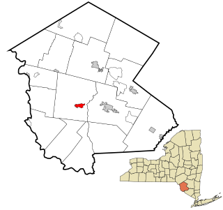
Sullivan County is a county in the U.S. state of New York. As of the 2020 census, the population was 78,624. The county seat is Monticello. The county's name honors Major General John Sullivan, who was labeled at the time as a hero in the American Revolutionary War in part due to his successful campaign against the Iroquois. The county is part of the Hudson Valley region of the state.

Woodstock is a town in Oxford County, Maine, United States. Woodstock is included in the Lewiston-Auburn, Maine metropolitan New England city and town area. The population was 1,352 at the 2020 census. The village of Bryant Pond, on State Route 26 in the northern part of Woodstock, is the town's urban center and largest settlement.

<span class="mw-page-title-main">Schroon, New York</span> Town in New York, United States

Schroon is a town in the Adirondack Park, in Essex County, New York, United States. The population was 1,880 at the 2020 census. The largest community in the town is the hamlet of Schroon Lake, located at the northern end of the lake of the same name.

<span class="mw-page-title-main">Middletown, New York</span> City in New York, United States

Middletown is the largest city in Orange County, New York, United States. It lies in New York's Hudson Valley region, near the Wallkill River and the foothills of the Shawangunk Mountains. Middletown is situated between Port Jervis and Newburgh, New York. At the 2020 United States census, the city's population was 30,345, reflecting an increase of 2,259 from the 28,086 counted in the 2010 census. The ZIP Code is 10940. Middletown falls within the Kiryas Joel–Poughkeepsie–Newburgh Metropolitan Statistical Area, which belongs to the larger New York–Newark–Bridgeport, NY–NJ–CT–PA Combined Statistical Area.

<span class="mw-page-title-main">Mount Hope, New York</span> Town in New York, United States

Mount Hope is a town in the northwestern part of Orange County, New York, United States, west of Middletown. The northern town line is the border of Sullivan County. The population was 6,537 at the 2020 census.

<span class="mw-page-title-main">Scotchtown, New York</span> Hamlet and CDP in New York, United States

Scotchtown is a hamlet in the Town of Wallkill, in Orange County, New York, United States. The population was 10,578 at the 2020 census. It has the ZIP Code 10941. The hamlet is located east of the City of Middletown. It is part of the Poughkeepsie–Newburgh–Middletown, NY Metropolitan Statistical Area as well as the larger New York–Newark–Bridgeport, NY-NJ-CT-PA Combined Statistical Area.

<span class="mw-page-title-main">Wallkill, Orange County, New York</span> Town in New York, United States

Wallkill is a town in Orange County, New York, United States. The population was 30,486 at the 2020 census. It is centrally located in the county. Interstate 84 crosses New York State Route 17 in the southern part of the town. U.S. Route 6 and New York State routes 17K, 211 and 302 also cross portions of the town.

<span class="mw-page-title-main">Cochecton, New York</span> Town in New York, United States

Cochecton is a town located in west-central Sullivan County, New York, United States. The population was 1,448 at the 2020 census. The name is derived from the Lenape word "cushetunk" meaning "place of red stone hills".

<span class="mw-page-title-main">Fallsburg, New York</span> Town in New York, United States

Fallsburg is a town in Sullivan County, New York, United States. The town is in the eastern part of the county. The population was 14,192 at the 2020 census. It is not to be confused with the hamlet of Fallsburg which bears a similar name and is within the town of Fallsburg.

<span class="mw-page-title-main">Smallwood, New York</span> Census-designated place in New York, US

Smallwood is a hamlet in Sullivan County, New York, United States. The population was 839 at the 2020 census.

<span class="mw-page-title-main">Hannibal, New York</span> Town in New York, United States

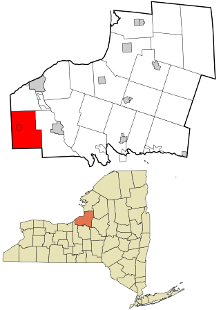
Hannibal is a town in Oswego County, New York, United States. The population was 4,854 at the 2010 census. The name is derived from the hero of ancient Carthage, Hannibal.

<span class="mw-page-title-main">Liberty, New York</span> Town in New York, United States

Liberty is a town in Sullivan County, New York, United States. The population was 10,159 at the 2020 census. The village is bisected by New York State Route 52 (NY 52) and NY 55, and is crossed by NY 17.

<span class="mw-page-title-main">Max Yasgur</span> American farmer (1919–1973)

Max Bernard Yasgur was an American farmer. He was the owner of the 600-acre (240 ha) dairy farm in Bethel, New York, where the Woodstock Music and Art Fair was held on August 15–18, 1969. He sold his farm in 1971 and retired to Florida, where he died in 1973.

Samuel Stephen Yasgur was an American attorney and Sullivan County, New York official. He was the son of Max Yasgur, who leased land on his 600 acres (2.4 km2) dairy farm in Bethel, New York for the Woodstock Music & Art Festival in August 1969. Yasgur said that his "consultations with his father" played a crucial role in the concert coming to Bethel. He grew up on his father's farm, and was a graduate of Cornell University and the University of Chicago Law School.

<span class="mw-page-title-main">Bethel Woods Center for the Arts</span> Performing arts center and museum

The Bethel Woods Center for the Arts is an amphitheatre, performing arts center and museum located at the site of the 1969 Woodstock Music & Art Fair in Bethel, New York. Located approximately 90 miles (140 km) from New York City, the 800-acre (3.2 km2) site includes a 15,000-seat outdoor concert venue, a 1,000-seat outdoor terrace stage, an intimate 440-seat indoor hall, and the Museum at Bethel Woods. Concerts run June through September and feature many types of music genres.

White Lake is a hamlet in the town of Bethel, Sullivan County, New York, United States, on the southeastern shore of a lake of the same name. It was the closest community to the Woodstock Music and Art Fair in 1969.

<span class="mw-page-title-main">Elliot Tiber</span> American artist, professor, and screenwriter (1935-2016)

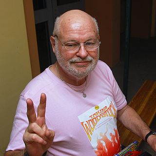
Elliot Michael Tiber was an artist, professor, and screenwriter who wrote a memoir about the Woodstock Festival held in Bethel, New York in 1969. He claimed responsibility for the relocation of the festival after a permit for it was withdrawn by the zoning board of a nearby town.

<span class="mw-page-title-main">Saugerties, New York</span> Town in Ulster County, New York, United States

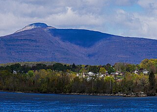
Saugerties is a town in the northeastern corner of Ulster County, New York. The population was 19,038 at the time of the 2020 Census, a decline from 19,482 in 2010. The village of the same name is located entirely within the town.

<span class="mw-page-title-main">Woodstock, New York</span> Town in New York, United States

Woodstock is a town in Ulster County, New York, United States, in the northern part of the county, northwest of Kingston. It lies within the borders of the Catskill Park. The population was 6,287 at the 2020 census, up from 5,884 in 2010.

References

  1. "2016 U.S. Gazetteer Files". United States Census Bureau. Retrieved July 5, 2017.
  2. "Bethel town, Sullivan County, New York". U.S. Census Bureau. Archived from the original on February 12, 2020. Retrieved April 13, 2009.
  3. "Census of Population and Housing". Census.gov. Retrieved June 4, 2015.
  4. 2020 United States Census, 2020 Census Report, Bethel town, Sullivan County, New York https://www.census.gov/search-results.html?searchType=web&cssp=SERP&q=Bethel%20town,%20Sullivan%20County,%20New%20York
  5. "U.S. Census website". United States Census Bureau . Retrieved January 31, 2008.
  6. Eager, Samuel Watkins (1846). An Outline History of Orange County: Together with Local Tradition and Short Biographical Sketches of Early Settlers, Etc. T. E. Henderson. p. 417.
  7. "National Register Information System". National Register of Historic Places . National Park Service. March 13, 2009.
  8. Nason, Robert (August 16, 2019). "When the Boy Scouts met the hippies at Woodstock". Los Angeles Times. Retrieved August 16, 2019.
  9. 50 years later, Sullivan County shows love for Woodstock festival
  10. Woodstock 2019: Bethel Woods ready for party 50 years in making
  11. Woodstock Gets a Low-Key 50th Party With Ringo, Santana and That Album Cover Couple

41°40′51″N74°51′57″W / 41.68083°N 74.86583°W / 41.68083; -74.86583