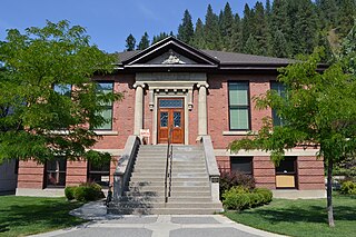
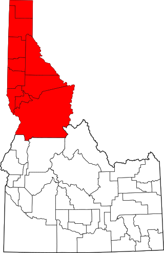
Shoshone County is a county in the U.S. state of Idaho. As of the 2020 census, the population was 13,169. The county seat is Wallace and the largest city is Kellogg. The county was established in 1864, named for the Native American Shoshone tribe.

Kellogg is a city in the Silver Valley of Shoshone County, Idaho, United States, in the Idaho Panhandle region. The city lies near the Coeur d'Alene National Forest and about 36 miles (58 km) east-southeast of Coeur d'Alene along Interstate 90. As of the 2010 United States Census, the city had a total population of 2,120, down by a third from its population in 1980.

Mullan is a city in the northwest United States, located in the Silver Valley mining district of northern Idaho. The population was 646 at the 2020 census and 692 at the 2010 census, and 840 in 2000.

Yellow Pine is an unincorporated census-designated place in Valley County, Idaho. As of the 2020 census, its population was 32. Yellow Pine has an area of 0.995 square miles (2.58 km2); 0.984 square miles (2.55 km2) of this is land, and 0.011 square miles (0.028 km2) is water.
The Idaho panhandle—locally known as North Idaho—is a salient region of the U.S. state of Idaho encompassing the state's 10 northernmost counties: Benewah, Bonner, Boundary, Clearwater, Idaho, Kootenai, Latah, Lewis, Nez Perce, and Shoshone. The panhandle is bordered by the state of Washington to the west, Montana to the east, and the Canadian province of British Columbia to the north. The Idaho panhandle, along with Eastern Washington, makes up the region known as the Inland Northwest, headed by its largest city, Spokane, Washington.

Murphy is a census-designated place in, and the county seat of, Owyhee County, Idaho, United States. It is among the smallest of county seats nationwide, with a population as of the 2020 census of 96. Murphy is part of the Boise City–Nampa, Idaho Metropolitan Statistical Area. Murphy is also located within the census-designated place bearing its name. Murphy is home to the Owyhee County Historical Museum and Library.

Avery is a small unincorporated community in the northwest United States, located in the St. Joe River Valley in Shoshone County, Idaho. Avery is located in the middle of the St. Joe District of the Idaho Panhandle National Forest, and is a tourist attraction in the Idaho Panhandle known for its wilderness and outdoor recreation. It is upstream and east of St. Maries, the county seat of Benewah County.

Blacklick is a small unincorporated community in southern Jefferson Township, Franklin County, Ohio, United States. Blacklick is also included in the Columbus Metropolitan area.

Clarkia is a small unincorporated community in the southwestern corner of Shoshone County, Idaho. It is surrounded by publicly and privately managed forest lands of Douglas-fir, Ponderosa Pine, and Western Larch. Located just to the east of State Highway 3, the town is in the drainage area of the West Fork of the St. Maries River.

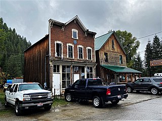
Burke is a ghost town in Shoshone County, Idaho, United States, established in 1887. Once a thriving silver, lead and zinc mining community, the town saw significant decline in the mid-twentieth century after the closure of several mines.
Silver Mountain Resort is a ski resort in the northwest United States, located in the Silver Valley region of northern Idaho, just south of Kellogg and Interstate 90 in Shoshone County. Originally opened as "Jackass Ski Bowl" in January 1968 on Wardner Peak, it was renamed "Silverhorn" in 1973 following an ownership change. With planned improvements, most notably the gondola from the city of Kellogg and expansion on Kellogg Peak, the name was changed to "Silver Mountain" in the summer of 1989.
The Silver Valley is a region in the northwest United States, in the Coeur d'Alene Mountains in northern Idaho. It is noted for its mining heritage, dating back to the 1880s.

Atlanta is an unincorporated community in the western United States, located in Elmore County, Idaho.

Burke Canyon is the canyon of the Burke-Canyon Creek, which runs through the northernmost part of Shoshone County, Idaho, U.S., within the northeastern Silver Valley. A hotbed for mining in the late-nineteenth and twentieth centuries, Burke Canyon now contains several ghost towns and remnants of former communities along Idaho State Highway 4, which runs northeast through the narrow canyon to the Montana border.

The Sunshine Mine is located between the cities of Kellogg and Wallace in northern Idaho. It has been one of the world's largest and most profitable silver mines, having produced over 360 million ounces of silver by 2001.
Corral is an unincorporated community in southwestern Camas County, Idaho, United States. It lies along U.S. Route 20 west of the city of Fairfield, the county seat of Camas County. Its elevation is 5,098 feet (1,554 m). Although Corral is unincorporated, it has a post office, with the ZIP code of 83322.

The Clearwater River is in the northwestern United States, in north central Idaho. Its length is 74.8 miles (120.4 km), it flows westward from the Bitterroot Mountains along the Idaho-Montana border, and joins the Snake River at Lewiston. In October 1805, the Lewis and Clark Expedition descended the Clearwater River in dugout canoes, putting in at "Canoe Camp," five miles (8 km) downstream from Orofino; they reached the Columbia Bar and the Pacific Ocean about six weeks later.
Murray is an unincorporated community in Shoshone County, Idaho, United States. It is twenty miles from Wallace along Dobson Pass Road. Prichard Creek flows through the community, forming a thin and deep valley in the surrounding Coeur d'Alene Mountains.
Coffee Creek is an unincorporated community in Fergus County, Montana, United States. It is located along Montana Highway 81 in west central Fergus County, several miles northwest of Denton. Coffee Creek has a post office with the ZIP code 59424.

