Bihar and Orissa Province

Last updated

Bihar and Orissa Province
Province of British India
1912–1936
British Raj Red Ensign.svg
Flag
Indian Embassy in London wall plaque (3).jpg
Coat of arms
Bihar and Orissa province.jpg
Bihar and Orissa in a 1912 map of British India
Capital Patna
History
History 
 Separation from Bengal
1912
 Bifurcation of Bihar and Orissa Province
1936
Preceded by
Succeeded by
British Raj Red Ensign.svg Bengal Presidency
Bihar Province British Raj Red Ensign.svg
Orissa Province British Raj Red Ensign.svg

Bihar and Orissa was a province of British India, [1] which included the present-day Indian states of Bihar, Jharkhand, and Odisha. The territories were conquered by the British in the 18th and 19th centuries, and were governed by the then Indian Civil Service of the Bengal Presidency, the largest administrative subdivision in British India.

Contents

On 22 March 1912, both Bihar and Orissa divisions were separated from the Bengal Presidency as Bihar and Orissa Province. On 1 April 1936, the province was partitioned into Bihar and the Orissa Province.

History

Bihar and Orissa in a 1907 map of British India before the creation of the province. Joppen1907BritishBengalBritishBurmaA.jpg
Bihar and Orissa in a 1907 map of British India before the creation of the province.

In 1756, Bihar and Orissa were part of the Mughal Empire, with Bihar being part of the Bengal Subah and Orissa being its own Subah.

The Treaty of Allahabad was signed on 16 August 1765, between the Mughal Emperor Shah Alam II, son of the late Emperor Alamgir II, and Robert, Lord Clive, of the East India Company, [1] as a result of the Battle of Buxar of 22 October 1764. The Treaty marks the political and constitutional involvement and the beginning of British rule in India. Based on the terms of the agreement, Alam granted the East India Company Diwani rights, or the right to collect taxes on behalf of the Emperor from the eastern province of Bengal-Bihar-Orissa. Bihar and Orissa was separated from Bengal on 22 March 1912, with Patna as capital. [2] A number of princely states, including the Orissa Tributary States, were under the authority of the provincial governor.

Dyarchy (1921–1937)

The Montagu–Chelmsford Reforms enacted through the Government of India Act 1919 expanded the Bihar & Orissa Legislative Council from 43 to 103 members. The Legislative Council now consisted of 2 ex-officio Executive Councillors, 25 nominated members (12 official, 13 non-official) and 76 elected members (48 Non-Muslim, 18 Muslim, 1 European, 3 Commerce & Industry, 5 Landholders and 1 University constituencies). [3] The reforms also introduced the principle of dyarchy, whereby certain responsibilities such as agriculture, health, education, and local government, were transferred to elected ministers.

NamePeriodDepartment
Khan Bahadur Syed Muhammad FakhruddinJanuary 1921 to 6 May 1933Education, Agriculture, Cooperative Credit Industries, Religious Endowment, Excise
Madhusudan Das January 1921 to 9 March 1923Local Self-Government, Medical Public Health, Public Works
Ganesh Dutt March 1923 till end of dyarchyLocal Self-Government, Medical Public Health, Public Works
Khan Bahadur Syed Muhammad Hussain6 May 1933 to 24 December 1933Education, Agriculture, Cooperative Credit Industries, Religious Endowment, Registration
Syed Muhammad Abdul Aziz15 January 1934 till end of dyarchyEducation, Agriculture, Cooperative Credit Industries, Religious Endowment, Registration

Division

On 1 April 1936, the province was divided into Bihar Province (which included present-day Bihar and Jharkhand states) and Orissa Province, and the Odia speaking princely states placed under the authority of the Eastern States Agency.

Governors of Bihar and Orissa

From 1912 to 1920, the province had a lieutenant governor heading the provincial government. This post was upgraded to governor in 1920, when Satyendra Prasanna Sinha, 1st Baron Sinha was appointed to fill it. [4]

Lieutenant governors

Governors

See also

Related Research Articles

<span class="mw-page-title-main">States and union territories of India</span> Indian national administrative subdivisions

India is a federal union comprising 28 states and 8 union territories, for a total of 36 entities. The states and union territories are further subdivided into districts and smaller administrative divisions.

<span class="mw-page-title-main">Satyendra Prasanna Sinha, 1st Baron Sinha</span> British Indian politician

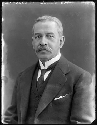
Satyendra Prasanna Sinha, 1st Baron Sinha, KCSI, PC, KC, was a prominent British Indian lawyer and statesman. He was the first Governor of Bihar and Orissa, first Indian Advocate-General of Bengal, first Indian to become a member of the Viceroy's Executive Council and the first Indian to become a member of the British ministry. He is sometimes also referred as Satyendra Prasanno Sinha or Satyendra Prasad Sinha.

<span class="mw-page-title-main">Shah Alam II</span> Mughal emperor from 1760 to 1788 and 1788 to 1806

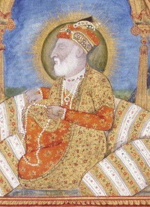
Shah Alam II, also known by his birth name Ali Gohar, or Ali Gauhar, was the seventeenth Mughal emperor and the son of Alamgir II. Shah Alam II became the emperor of a crumbling Mughal Empire. His power was so depleted during his reign that it led to a saying in the Persian language, Sultanat-e-Shah Alam, Az Dilli ta Palam, meaning, 'The empire of Shah Alam is from Delhi to Palam', Palam being a suburb of Delhi.

<span class="mw-page-title-main">Azim-ush-Shan</span> Mughal prince (1664–1712)

Mirza Azim-ush-Shan was the second son of Mughal emperor Shah Alam I, by his second wife, Amrita Bai, Princess of Kishangarh. He was the grandson of Emperor Aurangzeb, during whose reign, he was the subahdar (viceroy) of Bengal Subah, Bihar Subah and Orissa Subah from 1697 to his death in 1712, and the great grandson of Emperor Shah Jahan.

<span class="mw-page-title-main">History of Patna</span> Timeline of the Capital of Bihar

Patna, the capital of Bihar state, India, is one of the oldest continuously inhabited places in the world and the history of Patna spans at least three millennia. Patna has the distinction of being associated with the two most ancient religions of the world, namely, Buddhism and Jainism. The ancient city of Pataliputra was the capital of the Mauryan, Shunga, and Gupta Empires.

<span class="mw-page-title-main">Nawabs of Bengal</span> Rulers of Eastern India and Bengal in the 18th-century

The Nawab of Bengal was the hereditary ruler of Bengal Subah in Mughal India. In the early 18th-century, the Nawab of Bengal was the de facto independent ruler of the three regions of Bengal, Bihar and Orissa which constitute the modern-day sovereign country of Bangladesh and the Indian states of West Bengal, Bihar and Odisha. They are often referred to as the Nawab of Bengal, Bihar and Orissa. The Nawabs were based in Murshidabad which was centrally located within Bengal, Bihar, and Odisha. Their chief, a former prime minister, became the first Nawab. The Nawabs continued to issue coins in the name of the Mughal Emperor, but for all practical purposes, the Nawabs governed as independent monarchs. Bengal continued to contribute the largest share of funds to the imperial treasury in Delhi. The Nawabs, backed by bankers such as the Jagat Seth, became the financial backbone of the Mughal court. During the 18th century, the Nawabs of Bengal were among the wealthiest rulers in the world.

<span class="mw-page-title-main">Eastern States Agency</span> Agency of India from 1933 to 1947

The Eastern States Agency was an agency or grouping of princely states in eastern India, during the latter years of the Indian Empire. It was created in 1933, by the unification of the former Chhattisgarh States Agency and the Orissa States Agency; the agencies remained intact within the grouping. In 1936, the Bengal States Agency was added.

<span class="mw-page-title-main">Presidencies and provinces of British India</span> 1612–1947 British directly-ruled administrative divisions in India

The provinces of India, earlier presidencies of India and still earlier, presidency towns, were the administrative divisions of British governance on the Indian subcontinent. Collectively, they were called British India. In one form or another, they existed between 1612 and 1947, conventionally divided into three historical periods:

<span class="mw-page-title-main">Chota Nagpur Division</span>

Chota Nagpur Division, also known as the South-West Frontier, was an administrative division of British India. It included most of the present-day state of Jharkhand as well as adjacent portions of West Bengal, Orissa, and Chhattisgarh.

<span class="mw-page-title-main">Orissa Tributary States</span> Group of princely states in Odisha, India

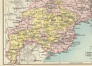
The Orissa Tributary States, also known as the Garhjats and as the Orissa Feudatory States, were a group of princely states of British India now part of the present-day Indian state of Odisha.

Sinha is a Sanskrit term and surname which originates in the Indian subcontinent. The surname is commonly used by the Kayasthas, typically the Bengali Kayasthas and the Kayasthas of Bihar and Jharkhand and is common in India, Sri Lanka, and Bangladesh. It comes from a Sanskrit word meaning "lion" or "brave person".

Bihar is a state located in the eastern part of India.

<span class="mw-page-title-main">Bihar Legislative Council</span> Upper house of the bicameral legislature of the state of Bihar in India

Bihar Legislative Council also known as Bihar Vidhan Parishad is the upper house of the bicameral Bihar Legislature of the state of Bihar in India.

<span class="mw-page-title-main">Council of State (India)</span>

The Council of State was the upper house of the legislature for British India created by the Government of India Act 1919 from the old Imperial Legislative Council, implementing the Montagu–Chelmsford Reforms. The Central Legislative Assembly was the lower house.

<span class="mw-page-title-main">Saraikela State</span> Princely state of British India in modern-day Jharkhand

Saraikela State also spelt Seraikela, Saraikella or Seraikella, was a princely state in India during the era of the British Raj, in the region that is now the Jharkhand state. Its capital was at Saraikela.

<span class="mw-page-title-main">Bengal Subah</span> Subdivision of the Mughal Empire

The Bengal Subah, also referred to as Mughal Bengal, was the largest subdivision of Mughal India encompassing much of the Bengal region, which includes modern-day Bangladesh and the Indian state of West Bengal, and some regions from the Indian states of Bihar, Jharkhand, Odisha between the 16th and 18th centuries. The state was established following the dissolution of the Bengal Sultanate, a major trading nation in the world, when the region was absorbed into the Mughal Empire. Bengal was the wealthiest region in the Indian subcontinent.

Sir Edward Albert Gait (1863–1950) was an administrator in the Indian Civil Service who rose to serve as Lieutenant-Governor of the Bihar and Orissa Province in the Bengal Presidency of British India. He held that office for the years 1915–1920, with a brief absence during April–July 1918 when Edward Vere Levinge officially acted in the position.

<span class="mw-page-title-main">Bihar Province</span> Province of British India (1936–1947)

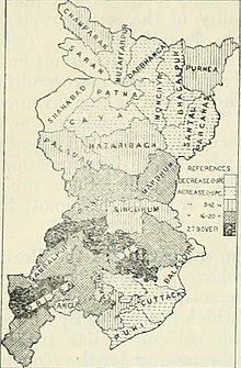
Bihar Province was a province of British India, created in 1936 by the partition of the Bihar and Orissa Province.

<span class="mw-page-title-main">Kharsawan State</span> Princely state of the British Raj

Kharsawan State, also spelt Kharsua or kharaswan, (Odia:ଖରସୁଆଁ)was a princely state in India during the era of the British Raj. The state had a privy purse of 33,000 Rs.It was one of the Odia Princely states of India during the period of the British Raj and the major language spoken in the area is Odia.

References

  1. 1 2 Chisholm, Hugh, ed. (1911). "Behar"  . Encyclopædia Britannica . Vol. 3 (11th ed.). Cambridge University Press. pp. 654–655.
  2. O'malley, L. S. S. (1924). Bihar And Orissa District Gazetteers Patna. Concept Publishing Company. ISBN   9788172681210.
  3. Alam, Jawaid (January 2004). Government and Politics in Colonial Bihar, 1921–1937. New Delhi: Mittal Publications. ISBN   81-7099-979-0.
  4. "Provinces – India". rulers.org. Retrieved 25 August 2020.

21°00′N86°18′E / 21.00°N 86.30°E / 21.00; 86.30