Bilston, Midlothian

Last updated

Bilston
Dryden Tower.jpg
Dryden Tower, a 19th-century Gothic folly overlooking Bilston
Midlothian UK location map.svg
Red pog.svg
Bilston
Location within Midlothian
Population1,440 (mid-2020 est.) [1]
OS grid reference NT262646
Council area
Lieutenancy area
Country Scotland
Sovereign state United Kingdom
Post town ROSLIN
Postcode district EH25
Dialling code 0131
Police Scotland
Fire Scottish
Ambulance Scottish
UK Parliament
Scottish Parliament
List of places
UK
Scotland
55°52′08″N3°10′44″W / 55.869°N 3.179°W / 55.869; -3.179

Bilston is a small village in Midlothian, Scotland. It is located on the edge of Edinburgh, just south of Loanhead on the A701. The Bilston Burn Site of Special Scientific Interest (SSSI) was occupied from 2002 until the mid-2010s by protestors who successfully opposed plans for a bypass.

Contents

History

Bilston is a village which was set up to service the local coal-mining industry. The Bilston Glen Colliery produced coal for the British Empire, finally closing in 1989. [2] [3] It is located next to woodland and the Bilston Glen industrial estate. The village is overlooked by a tower which used be part of the Dryden House, which was set on a hill overlooking the River Forth. [4] Bilston Burn is a tributary of the River North Esk. It flows east from the village, and the woods it runs through are classified as a Site of Special Scientific Interest (SSSI). [5] John Comyn stayed in the woods with his troops before the Battle of Roslin in 1303. [6]

Bilston has a primary school, Bilston Primary. [7] Police Scotland run a control room at Bilston Glen and during the COVID-19 pandemic in Scotland set up a coronavirus control centre there. [8]

Bypass and camp

A proposed bypass, taking the A701 east of the village from Straiton to Milton Bridge outside Penicuik, was put forward by Midlothian Council in 2000. It was included in the local development plan. [9] One of the proposed routes of the bypass was through the SSSI woodland at Bilston Glen. Despite objections from local people and conservationists who submitted 700 objections, Midlothian Council and the Scottish Executive approved the route. It was challenged legally but the Scottish transport minister Sarah Boyack declined to open an inquiry about the £18.5 million scheme. [10]

In response, Bilston Glen was occupied in 2002 in order to prevent the SSSI being destroyed. Ten years later, the camp was still there, with protestors careful not to build any permanent structures which would damage the woodland. [10] [11] It became known as one of the longest-running tree protection sites in the world. [12]

The 2015 local development plan proposed building more houses in Bilston and turning the current A701 road into a route for public transport, cyclists and walkers, as part of the revised "Midlothian Gateway" plan. [13]

See also

Related Research Articles

<span class="mw-page-title-main">Midlothian</span> Council area of Scotland

Midlothian is a historic county, registration county, lieutenancy area and one of 32 council areas of Scotland used for local government. Midlothian lies in the east-central Lowlands, bordering the City of Edinburgh council area, East Lothian and the Scottish Borders.

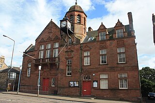
Bonnyrigg is a town in Midlothian, Scotland, which is eight miles southeast of Edinburgh city centre. The town had a population of 14,663 in the 2001 census which rose to 15,677 in the 2011 census, both figures based on the 2010 definition of the locality which, as well as Bonnyrigg and the adjacent settlement of Lasswade, includes Polton village, Poltonhall housing estate and modern development at Hopefield. The estimated population for 2018 is 18,120, the highest of any town in Midlothian. Along with Lasswade, Bonnyrigg is a twin town with Saint-Cyr-l'École, France.

<span class="mw-page-title-main">Penicuik</span> Town in Midlothian, Scotland

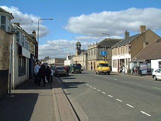
Penicuik is a town and former burgh in Midlothian, Scotland, lying on the west bank of the River North Esk. It lies on the A701 midway between Edinburgh and Peebles, east of the Pentland Hills.

<span class="mw-page-title-main">River Esk, Lothian</span> River in Midlothian and East Lothian, Scotland

The River Esk, also called the Lothian Esk, is a river that flows through Midlothian and East Lothian, Scotland.

<span class="mw-page-title-main">Loanhead</span> Human settlement in Scotland

Loanhead is a town in Midlothian, Scotland, in a commuter belt to the south of Edinburgh, and close to Roslin, Bonnyrigg and Dalkeith. The town was built on coal and oil shale mining, and the paper industries.

<span class="mw-page-title-main">Whitburn, West Lothian</span> Human settlement in Scotland

Whitburn is a small town in West Lothian, Scotland, halfway between Scotlands's two largest cities, about 23 miles east of Glasgow and 22 miles west of Edinburgh. The nearest major towns are Bathgate, four miles and Livingston, six miles.

<span class="mw-page-title-main">Roslin, Midlothian</span> Village in Midlothian, Scotland

Roslin is a village in Midlothian, Scotland, 11 kilometres (7 mi) to the south of the capital city Edinburgh. It stands on high ground, near the northwest bank of the river North Esk.

<span class="mw-page-title-main">Lasswade</span> Human settlement in Scotland

Lasswade is a village and civil parish in Midlothian, Scotland, on the River North Esk, nine miles south of Edinburgh city centre, contiguous with Bonnyrigg and between Dalkeith to the east and Loanhead to the west. Melville Castle lies to the north east. The Gaelic form is Leas Bhaid, meaning the "clump at the fort."

<span class="mw-page-title-main">Roslin Castle</span> Castle near Roslin in Midlothian, Scotland

Roslin Castle is a partially ruined castle near the village of Roslin in Midlothian, Scotland. It is located around 9 mi (14 km) south of Edinburgh, on the north bank of the North Esk, only a few hundred metres from the famous Rosslyn Chapel.

<span class="mw-page-title-main">Rosewell, Midlothian</span> Village in Midlothian, Scotland

Rosewell is a former mining village in Midlothian, Scotland, east of Roslin and south-west of Bonnyrigg. The village is in the civil parish of Lasswade and was previously a separate ecclesiastical parish, but has its own Community Council, namely Rosewell and District.

<span class="mw-page-title-main">Edgehead</span> Human settlement in Scotland

Edgehead is a village in Midlothian, Scotland.

The Edinburgh, Loanhead and Roslin Railway was a railway line south of Edinburgh, Scotland, built primarily to serve mineral workings, although passenger trains were operated. It is also known as the Glencorse Branch of the North British Railway. It opened from a junction at Millerhill on the Waverley Route, to Roslin in 1874 and was extended to a location near Penicuik to serve Glencorse Barracks and a colliery in 1877 and to Penicuik Gas Works in 1878.

The Mauricewood Colliery Disaster, occurred at the Mauricewood pit, near Penicuik, Midlothian, Scotland on 5 September 1889. A total of 63 miners were killed. At the time the mine was owned by the Shotts Iron Company Ltd.

The Penicuik Railway was a railway line in Midlothian, Scotland, serving paper mills located on the River North Esk. It opened in 1872 and a substantial residential passenger traffic built up. The line was 4 1/2 miles long.

<span class="mw-page-title-main">Edinburgh Science Triangle</span>

The Edinburgh Science Triangle (EST) is a multi-disciplinary partnership between universities, research institutes, the National Health Service, science parks, the national economic development agency Scottish Enterprise, and central and local government in Edinburgh and neighbouring council areas. The three points of the "triangle" are Livingston in West Lothian, Musselburgh in East Lothian, and the Easter Bush campus in Midlothian.

<span class="mw-page-title-main">Penicuik–Dalkeith Walkway</span> Route in Midlothian in the east of Scotland

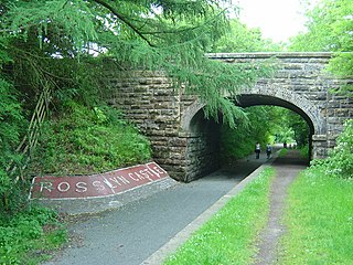
The Penicuik - Dalkeith Walkway, situated in the county of Midlothian in the east of Scotland, stretches for 9.5 miles along the former Edinburgh to Peebles railway. The route passes through many of Midlothian's historic towns and villages. The gentle gradient and nature of the route allows easy access for walkers, cyclists and horse riders to explore and enjoy the spectacular landscapes and visitor attractions of the county.

Glencorse is a parish of Midlothian, Scotland, lying 7 miles south of Edinburgh. It is bounded on the north-west by the former parish of Colinton now within the City of Edinburgh, to the north and west by Lasswade and to the south and west by Penicuik.

Glencorse railway station served the parish of Glencorse, Midlothian, Scotland, from 1877 to 1959 on the Edinburgh, Loanhead and Roslin Railway.

References

  1. "Mid-2020 Population Estimates for Settlements and Localities in Scotland". National Records of Scotland. 31 March 2022. Retrieved 31 March 2022.
  2. Blackstock, Gordon (19 June 2016). "The four childhood pals who escaped a life of mining to make their millions". The Sunday Post. Retrieved 19 September 2020.
  3. "Disused Stations: Millerhill Station". www.disused-stations.org.uk. Retrieved 19 September 2020.
  4. "Bilston Midlothian Scotland". Lothian and Borders. Retrieved 19 September 2020.
  5. "Bilston Burn SSSI". sitelink.nature.scot. Retrieved 19 September 2020.
  6. Newsroom (24 February 2017). "Roslin 1303: Scotland's forgotten battle". Scotsman. Retrieved 19 September 2020.
  7. Norman, Rob. "Bilston Primary School". www.midlothian.gov.uk. Retrieved 16 December 2016.
  8. Matchett, Conor (20 March 2020). "Police Scotland launch coronavirus major incident response with control centre based in Midlothian". Scotsman. Retrieved 19 September 2020.
  9. "Midlothian Local Plan INSET MAP 3 A701 CORRIDOR NORTH" (PDF). Midlothian Council. Archived from the original (PDF) on 20 August 2006. Retrieved 9 July 2010.
  10. 1 2 Davidson, Gina (21 February 2012). "Bilston Glen camp determined to beat bypass plans". Scotsman. Retrieved 19 September 2020.
  11. "Bilston Glen road protest". Archived from the original on 3 February 2011. Retrieved 20 November 2007.
  12. Pike, Sarah M. (3 October 2017). For the Wild: Ritual and Commitment in Radical Eco-Activism. University of California Press. p. 40. ISBN   978-0-520-29495-0 . Retrieved 19 September 2020.
  13. Scott, Thomas (14 May 2015). "The Long Read: Midlothian 2020". Penicuik Cuckoo. Retrieved 19 September 2020.