Related Research Articles

Geophysics is a subject of natural science concerned with the physical processes and physical properties of the Earth and its surrounding space environment, and the use of quantitative methods for their analysis. The term geophysics sometimes refers only to geological applications: Earth's shape; its gravitational and magnetic fields; its internal structure and composition; its dynamics and their surface expression in plate tectonics, the generation of magmas, volcanism and rock formation. However, modern geophysics organizations and pure scientists use a broader definition that includes the water cycle including snow and ice; fluid dynamics of the oceans and the atmosphere; electricity and magnetism in the ionosphere and magnetosphere and solar-terrestrial relations; and analogous problems associated with the Moon and other planets.

The asthenosphere is the highly viscous, mechanically weak and ductile region of the upper mantle of Earth. It lies below the lithosphere, at depths between approximately 80 and 200 km below the surface. The lithosphere–asthenosphere boundary is usually referred to as LAB. The asthenosphere is almost solid, although some of its regions could be molten. The lower boundary of the asthenosphere is not well defined. The thickness of the asthenosphere depends mainly on the temperature. However, the rheology of the asthenosphere also depends on the rate of deformation, which suggests that the asthenosphere could be also formed as a result of a high rate of deformation. In some regions the asthenosphere could extend as deep as 700 km (430 mi). It is considered the source region of mid-ocean ridge basalt (MORB).
There are several conflicting definitions for geosphere.

Continental crust is the layer of igneous, sedimentary, and metamorphic rocks that forms the geological continents and the areas of shallow seabed close to their shores, known as continental shelves. This layer is sometimes called sial because its bulk composition is richer in silicates and aluminium minerals and has a lower density compared to the oceanic crust, called sima which is richer in magnesium silicate minerals and is denser. Changes in seismic wave velocities have shown that at a certain depth, there is a reasonably sharp contrast between the more felsic upper continental crust and the lower continental crust, which is more mafic in character.

Geobiology is a field of scientific research that explores the interactions between the physical Earth and the biosphere. It is a relatively young field, and its borders are fluid. There is considerable overlap with the fields of ecology, evolutionary biology, microbiology, paleontology, and particularly soil science and biogeochemistry. Geobiology applies the principles and methods of biology, geology, and soil science to the study of the ancient history of the co-evolution of life and Earth as well as the role of life in the modern world. Geobiologic studies tend to be focused on microorganisms, and on the role that life plays in altering the chemical and physical environment of the pedosphere, which exists at the intersection of the lithosphere, atmosphere, hydrosphere and/or cryosphere. It differs from biogeochemistry in that the focus is on processes and organisms over space and time rather than on global chemical cycles.
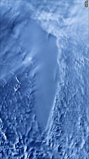
A subglacial lake is a lake that is found under a glacier, typically beneath an ice cap or ice sheet. Subglacial lakes form at the boundary between ice and the underlying bedrock, where gravitational pressure decreases the pressure melting point of ice. Over time, the overlying ice gradually melts at a rate of a few millimeters per year. Meltwater flows from regions of high to low hydraulic pressure under the ice and pools, creating a body of liquid water that can be isolated from the external environment for millions of years.

Cluster II is a space mission of the European Space Agency, with NASA participation, to study the Earth's magnetosphere over the course of nearly two solar cycles. The mission is composed of four identical spacecraft flying in a tetrahedral formation. As a replacement for the original Cluster spacecraft which were lost in a launch failure in 1996, the four Cluster II spacecraft were successfully launched in pairs in July and August 2000 onboard two Soyuz-Fregat rockets from Baikonur, Kazakhstan. In February 2011, Cluster II celebrated 10 years of successful scientific operations in space. As of November 2018 its mission has been extended until the end of 2020 with a likely extension lasting until 2022. China National Space Administration/ESA Double Star mission operated alongside Cluster II from 2004 to 2007.
The European Geosciences Union (EGU) is a non-profit international union in the fields of Earth, planetary, and space sciences whose vision is to "realise a sustainable and just future for humanity and for the planet." The organisation has headquarters in Munich (Germany). Membership is open to individuals who are professionally engaged in or associated with these fields and related studies, including students and retired seniors.
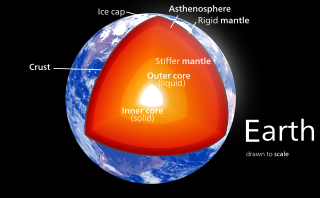
Earth's inner core is the innermost geologic layer of the planet Earth. It is primarily a solid ball with a radius of about 1,220 km (760 mi), which is about 20% of Earth's radius or 70% of the Moon's radius.
The Journal of Geophysical Research is a peer-reviewed scientific journal. It is the flagship journal of the American Geophysical Union. It contains original research on the physical, chemical, and biological processes that contribute to the understanding of the Earth, Sun, and solar system. It has seven sections: A, B, C (Oceans), D (Atmospheres), E (Planets), F, and G (Biogeosciences). All current and back issues are available online for subscribers.
A slow earthquake is a discontinuous, earthquake-like event that releases energy over a period of hours to months, rather than the seconds to minutes characteristic of a typical earthquake. First detected using long term strain measurements, most slow earthquakes now appear to be accompanied by fluid flow and related tremor, which can be detected and approximately located using seismometer data filtered appropriately. That is, they are quiet compared to a regular earthquake, but not "silent" as described in the past.
Episodic tremor and slip (ETS) is a seismological phenomenon observed in some subduction zones that is characterized by non-earthquake seismic rumbling, or tremor, and slow slip along the plate interface. Slow slip events are distinguished from earthquakes by their propagation speed and focus. In slow slip events, there is an apparent reversal of crustal motion, although the fault motion remains consistent with the direction of subduction. ETS events themselves are imperceptible to human beings and do not cause damage.
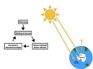
Ice–albedo feedback is a positive feedback climate process where a change in the area of ice caps, glaciers, and sea ice alters the albedo and surface temperature of a planet. Ice is very reflective, therefore some of the solar energy is reflected back to space. Ice–albedo feedback plays an important role in global climate change. For instance at higher latitudes, we see warmer temperatures melt the ice sheets. However, if warm temperatures decrease the ice cover and the area is replaced by water or land the albedo would decrease. This increases the amount of solar energy absorbed, leading to more warming. The effect has mostly been discussed in terms of the recent trend of declining Arctic sea ice. The change in albedo acts to reinforce the initial alteration in ice area leading to more warming. Warming tends to decrease ice cover and hence decrease the albedo, increasing the amount of solar energy absorbed and leading to more warming. In the geologically recent past, the ice-albedo positive feedback has played a major role in the advances and retreats of the Pleistocene ice sheets. Inversely, cooler temperatures increase ice, which increases albedo, leading to more cooling.
Carmen Gaina is the Director of the Centre for Earth Evolution and Dynamics (CEED) a Norwegian Centre of Excellence hosted at the Department of Geosciences, University of Oslo, Norway.
Reviews of Geophysics is a quarterly peer-reviewed scientific journal published by Wiley-Blackwell on behalf of the American Geophysical Union. The current editor-in-chief is Fabio Florindo.
Martha Kane Savage is a New Zealand geology academic, and as of 2018, is a full professor at the Victoria University of Wellington.

Estella Atekwana is a geophysicist studying biogeophysics and tectonophysics. She is currently Dean of the College of Earth, Ocean and Environment at the University of Delaware. She is also an adjunct professor at both the University of Waterloo and the Missouri University of Science and Technology. Before joining the University of Delaware in 2017, she was the Department Head of the Boone Pickens School of Geology at Oklahoma State University. She is a Regents Distinguished Professor and a Clyde Wheeler Sun Endowed Chair at Oklahoma State University, where she maintains an adjunct appointment. Atekwana has also been a faculty member at Missouri University of Science & Technology, Indiana University-Purdue University Indianapolis, and Western Michigan University.
Signs Of LIfe Detector (SOLID) is an analytical instrument under development to detect extraterrestrial life in the form of organic biosignatures obtained from a core drill during planetary exploration.
Richard Mansergh Thorne was an American physicist and a Distinguished Professor in the department of Atmospheric and Oceanic Sciences at UCLA. He was known for his contributions to space plasma physics. He was a fellow of the American Geophysical Union.
Efi Foufoula-Georgiou is a Distinguished Professor in the Civil and Environmental Engineering department at the University of California, Irvine. She is well known for her research on the applications of wavelet analysis in the fields of hydrology and geophysics and her many contributions to academic journals and national committees.
References
- ↑ Atekwana, Estella A.; Slater, Lee D. (2009). "Biogeophysics: A new frontier in Earth science research". Reviews of Geophysics. 47 (RG4004). Bibcode:2009RvGeo..47.4004A. doi:10.1029/2009RG000285.
- ↑ Slater, Lee; Atekwana, Estella A. (2011). "Biogeophysics". In Gupta, H. K. (ed.). Encyclopedia of Solid Earth Geophysics. Encyclopedia of Earth Sciences Series. Springer. pp. 25–29. doi:10.1007/978-90-481-8702-7_172. ISBN 978-90-481-8701-0.