

Bloxham Village Museum is a local museum located in the village of Bloxham in Oxfordshire, England. [1]
Bloxham Village Museum is a local museum located in the village of Bloxham in Oxfordshire, England. [1]
The museum was established in 1980. [2]
The museum is in the old court house and fire station in a corner of St Mary's churchyard. The building was rebuilt in the 1680s and retains some 14th-century details. [3]
This small, volunteer-run museum reflects past life in the ancient and beautiful village of Bloxham with a different themed exhibition each year. The museum is open from Easter until October.

Oxfordshire is a historic, ceremonial and non-metropolitan county in South East England. It is a mainly rural county, with its largest settlement being the city of Oxford. The county is a centre of research and development, primarily due to the work of the University of Oxford. Oxfordshire is locally governed by Oxfordshire County Council, together with the lower tier councils of its five non-metropolitan districts: City of Oxford, Cherwell, South Oxfordshire, Vale of White Horse, and West Oxfordshire. The ceremonial county is landlocked and bordered by Northamptonshire to the north-east, Warwickshire to the north-west, Buckinghamshire to the east, Berkshire to the south, Wiltshire to the south-west, and Gloucestershire to the west. The areas of Oxfordshire south of the River Thames were part of the historic county of Berkshire, including the county's highest point, the 261-metre (856 ft) White Horse Hill.
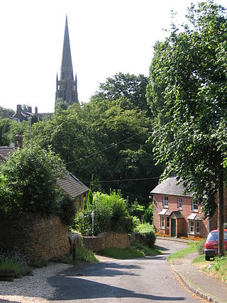
Bloxham is a village and civil parish in northern Oxfordshire several miles from the Cotswolds, about 3 miles (5 km) southwest of Banbury. It is on the edge of a valley and overlooked by Hobb Hill. The village is on the A361 road. The 2011 Census recorded the parish's population as 3,374.

South Stoke is a village and civil parish on an east bank of the Thames, about 1.5 miles (2.4 km) north of Goring-on-Thames in South Oxfordshire. It includes less than 1 mile (1.6 km) to its north the hamlet and manor house of Littlestoke.

Bodicote is a village and civil parish about 2 miles (3 km) south of the centre of Banbury in Oxfordshire. The 2011 Census recorded the parish's population as 2,126.

Broughton is a village and civil parish in northern Oxfordshire, England, about 2+1⁄2 miles (4 km) southwest of Banbury. The 2011 Census recorded the parish's population as 286.

North Newington is a village and civil parish in northern Oxfordshire, England, about 2 miles (3 km) west of Banbury. The 2011 Census recorded the parish population as 324. The parish is nearly 2 miles (3 km) long east – west and about 1 mile (1.6 km) wide north – south. Sor Brook, a tributary of the River Cherwell, forms part of the eastern boundary of the parish and the B4035 road forms part of the southern boundary. The village is just west of Sor Brook, about 430 feet (130 m) above sea level.
Cogges Manor Farm is a one-time working farm in Cogges near Witney in Oxfordshire, England, now a heritage centre operated by a charitable trust and open to the public.

Wroxton is a village and civil parish in the north of Oxfordshire about 3 miles (5 km) west of Banbury. The 2011 Census recorded the parish's population as 546.

Shenington is a village about 5 miles (8 km) west of Banbury in the United Kingdom. It was an exclave of Gloucestershire until the Counties Act 1844 transferred it to Oxfordshire. Shenington is on Oxfordshire's boundary with Warwickshire. Shenington was an ancient parish of 1,628 acres (659 ha). It is now part of the civil parish of Shenington with Alkerton.

Balscote or Balscott is a village in the civil parish of Wroxton, Oxfordshire, about 4 miles (6.4 km) west of Banbury. The Domesday Book of 1086 records the place-name as Berescote. Curia regis rolls from 1204 and 1208 record it as Belescot. An entry in the Book of Fees for 1242 records it as Balescot. Its origin is Old English, meaning the cottage, house or manor of a man called Bælli.

Heythrop is a village and civil parish just over 2 miles (3 km) east of Chipping Norton, Oxfordshire. The parish includes the hamlet of Dunthrop. The 2001 Census recorded the parish population as 93.

Great Rollright is a village in the civil parish of Rollright, about 2.5 miles (4 km) north of Chipping Norton, Oxfordshire.

Milton is a village and civil parish about 2.5 miles (4 km) south of Banbury in Oxfordshire, on the Milton road between the villages of Adderbury and Bloxham.

Wigginton is a village and civil parish about 6 miles (10 km) southwest of Banbury in Oxfordshire. The village is beside the River Swere, which forms the southern boundary of the parish. A Channel Four documentary, Hitler's British Girl, investigated the possibility that Unity Mitford gave birth to the son of Adolf Hitler in Hill View Cottage, Wigginton.

Milcombe is a village and civil parish about 5 miles (8 km) southwest of Banbury, Oxfordshire. Pronounced Mill-Comb-Bee. Milcombe is famous for its village shop. Originally called ‘John’s shop’ or More officially, ‘New Road Stores’ but is now called ‘Best-one’.
Epwell is a village and civil parish in the north of Oxfordshire about 6 miles (10 km) west of Banbury. The 2011 Census recorded the parish population's as 285. Epwell's toponym is believed to be derived from the Old English Eoppa's Well.

Kiddington is a village on the River Glyme in the civil parish of Kiddington with Asterleigh about 7 miles (11 km) southeast of Chipping Norton, Oxfordshire. The village is just north of the A44 road between Woodstock and Chipping Norton.

Alkerton is a village about 5 miles (8 km) west of Banbury in Oxfordshire, on the county boundary with Warwickshire.

The Parish Church of Saint Peter ad Vincula, South Newington is the Church of England parish church of South Newington, a village about 5 miles (8 km) southwest of Banbury in Oxfordshire. The church is one of only 15 in England dedicated to St Peter ad Vincula, after the basilica of San Pietro in Vincoli in Rome.

The church of Our Lady of Bloxham, informally called St Mary's Bloxham, is the Church of England parish church in Bloxham, Oxfordshire. It is notable for its 14th-century tower and spire, which is the highest in Oxfordshire. It is unusually large for a parish church. The architectural historian Jennifer Sherwood described it as "one of the grandest churches in the country." It is a Grade I listed building.
Coordinates: 52°01′03″N1°22′30″W / 52.0176°N 1.3751°W
| | This article relating to a museum in the United Kingdom is a stub. You can help Wikipedia by expanding it. |