Related Research Articles

The Warsaw Metro is a rapid transit underground system serving the Polish capital Warsaw. It currently consists of two lines, the north–south Line M1 which links central Warsaw with its densely populated northern and southern districts, and the east–west Line M2. Three more lines are still being planned. The system is operated by Metro Warszawskie sp. z o.o., a company owned by the city, and managed by Zarząd Transportu Miejskiego w Warszawie. As of 2024 it is the only metro system in Poland.
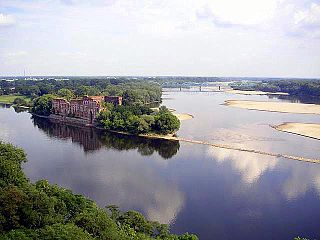
Modlin Fortress is one of the largest 19th-century fortresses in Poland. It is located in the town of Nowy Dwór Mazowiecki in district Modlin on the Narew river, approximately 50 kilometers north of Warsaw. It was originally constructed by the French from 1806 to 1812.

Jerusalem Avenue is one of the principal streets of the capital city of Warsaw in Poland. It runs through the City Centre along the East-West axis, linking the western borough of Wola with the bridge on the Vistula River and the borough of Praga on the other side of the river.

Zakroczym is a small town in the Masovian Voivodeship, Poland. It is located at around 52°26′16″N20°36′43″E. The Vistula River flows through the town. Zakroczym has a long and rich history: in the Kingdom of Poland and the Polish–Lithuanian Commonwealth, it was the capital of an administrative unit (ziemia), part of Mazovian Voivodeship. Also, Zakroczym was a royal town of the Crown of the Kingdom of Poland. The town lies at the intersection of two main roads - national road 62, and national road 7.
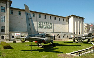
Museum of the Polish Army is a museum in Warsaw documenting the military history of Poland. Established in 1920 under the Second Polish Republic, it occupies a wing of the building of the Polish National Museum as well as several branches in Poland. It is Warsaw's second largest museum and the largest collection of military objects in Poland. The collection illustrates a thousand years of Polish military history, from the 10th century to the Second World War.

Saska Kępa is a neighbourhood in Warsaw, Poland, part of the Praga Południe district, with a population of over 40.000 inhabitants. It is also the home to one of Warsaw's largest urban parks, the Skaryszew Park. The neighbourhood is mostly occupied by semi-detached suburban houses and villas.

Warsaw Modlin Airport is an international airport located in the town of Nowy Dwór Mazowiecki, approximately 40 km north of central Warsaw, Poland. The airport is intended to be used by low-cost carriers serving Warsaw. As of 2017, it is the fifth busiest airport in the country, with 2,932,639 passengers served annually. The airport's only regular connections are served by Ryanair, while other carriers, such as Enter Air, operate seasonal services. The main international airport of the city is Warsaw Chopin Airport.

Ulica Świętokrzyska in Warsaw's city centre is one of the Polish city's principal thoroughfares. It links the city's centre with Wola borough.

Rakowiec is a neighbourhood in Warsaw, the capital of Poland. Part of the borough of Ochota, it originally was a separate village, established in the Middle Ages. Nationalised by the Russian authorities in the late 19th century, the village was occupied by one of the forts of the Warsaw Fortress. After Poland regained her independence, in 1930 the area was incorporated into Warsaw, and residential areas were soon built there.

St. Lawrence's Church is a Roman Catholic church located in Warsaw's borough of Wola. A neoclassicist building, the site is best known as the central point of Polish "Redoubt No. 56" during the 1831 battle for Warsaw.

Młynów is a neighbourhood of the western borough of Wola in Warsaw, the capital of Poland.

Artur Zawisza Square is a public square in Warsaw's borough of Ochota. It is named after Artur Zawisza, a 19th-century Polish revolutionary who was executed on the spot by Russians in 1833.
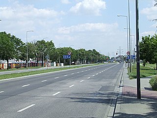
Połczyńska Street is a major thoroughfare in Warsaw, Poland. Located in the western part of the city, in the borough of Bemowo, the street crosses the neighbourhoods of Chrzanów and Jelonki. It starts as a continuation of Wolska Street, crosses Powstańców Śląskich Street and leaves the city where it becomes the Poznańska Street of Ożarów Mazowiecki. Historically the street, variously known as the Kalisz Road, Poznań Road or Greater Poland Road, was the main road from Warsaw towards Błonie, Sochaczew, Kalisz and ultimately Poznań. Its entire length was formally incorporated into the city of Warsaw in 1950s.

Warsaw-Babice is an airport in Warsaw, located in the residential district of Bemowo, near the border with the district of Bielany. It is also unofficially known as Bemowo.

Line M2 is the second line of the Warsaw Metro. It is currently 18.9 kilometres (11.7 mi) long, has 18 stations and runs from Bródno neighborhood in Targówek district to the Górce district in Bemowo. The planned line completion is in 2026, and will run from Targówek to Bemowo and number 21 stations.
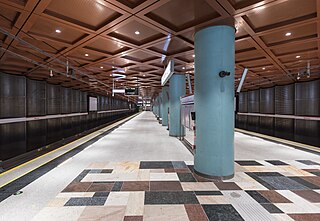
Bemowo is a metro station on the western part of Line M2 of the Warsaw Metro. It is located in the vicinity of Górczewska and Powstańców Śląskich streets, in the Bemowo district.

Ulrychów is a metro station on the western part of Line M2 of the Warsaw Metro. It is located by Górczewska Street, in the vicinity of the Wola Park shopping mall in Wola district.

Jelonki, prior to 1951 known as Jelonek, is a residential neighbourhood in the city of Warsaw, Poland, located within the district of Bemowo. The City Information System divides the neighbourhood into two areas, Jelonki Północne and Jelonki Południowe.

Chrzanów is a residential neighbourhood, and an area of the Municipal Information System, in the city of Warsaw, Poland, located within the district of Bemowo.

Radiowo is a neighbourhood, and a City Information System area, in Warsaw, Poland, located within the district of Bielany.
References
- "Historia Boernerowa". Internetowa Republika Bemowo (in Polish). Archived from the original on 2007-03-18. Retrieved 2007-05-13.
52°15′N20°54′E / 52.250°N 20.900°E
| | This Warsaw-related location article is a stub. You can help Wikipedia by expanding it. |