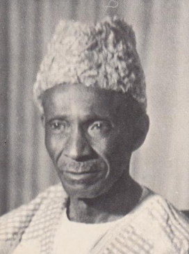
Sir Milton Augustus Strieby Margai was a Sierra Leonean medical doctor and politician who served as the country's head of government from 1954 until his death in 1964. He was titled chief minister from 1954 to 1960, and then prime minister from 1961 onwards. Margai studied medicine in England, and upon returning to his homeland became a prominent public health campaigner. He entered politics as the founder and inaugural leader of the Sierra Leone People's Party. Margai oversaw Sierra Leone's transition to independence, which occurred in 1961. He died in office aged 68, and was succeeded as prime minister by his brother Albert. Margai enjoyed the support of Sierra Leoneans across classes, who respected his moderate style, friendly demeanor, and political savvy.

Sherbro Island is in the Atlantic Ocean, and is included within Bonthe District, Southern Province, Sierra Leone. The island is separated from the African mainland by the Sherbro River in the north and Sherbro Strait in the east. It is 32 miles (51 km) long and up to 15 miles (24 km) wide, covering an area of approximately 230 square miles (600 km2). The western extremity is Cape St. Ann. Bonthe, on the eastern end, is the chief port and commercial centre.

Julius Maada Wonie Bio is a Sierra Leonean politician, and the current president of Sierra Leone since 4 April 2018. He is a retired brigadier in the Sierra Leone Army and was the military head of state of Sierra Leone from 16 January 1996 to 29 March 1996, in a military junta government known as the National Provisional Ruling Council (NPRC).

Pujehun District is a district in the Southern Province of Sierra Leone. Pujehun District is one of the sixteen Districts of Sierra Leone. Its capital and largest city is the town of Pujehun. The other major towns in the district include Gandorhun, Zimmi, Gendema, Masam, Bomi and Potoru. As of 2015, the district has a population of 345,577.

Bo District is a district in the Southern Province of Sierra Leone. It is one of the sixteen districts of Sierra Leone. Bo District is the second most populous district in Sierra Leone. Its capital and largest city is the city of Bo, which is also the second most populous city in Sierra Leone. Other major towns in the district include Baoma, Bumpeh, Serabu, Sumbuya, Baiima and Yele.
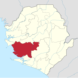
Moyamba District is a district in the Southern Province of Sierra Leone, with a population of 318,064 in the 2015 census. Its capital and largest city is Moyamba. The other major towns include Njala, Rotifunk and Shenge. The district is the largest in the Southern Province by geographical area, occupying a total area of 6,902 km2 (2,665 sq mi) and comprises fourteen chiefdoms.

Kailahun is the capital of Kailahun District in the Eastern Province of Sierra Leone. Kailahun is a major business and commercial center of Kailahun District. The population was 13,108 in the 2004 census, a 2006 estimate of 18,411 and a current estimate of about 30,411. Kailahun lies in the far east of Sierra Leone, approximately 200 miles east of Freetown, about 51 miles north east of Kenema, and near the border of Liberia.

Bombali is a district in the Northern Province of Sierra Leone. Its capital and largest city is Makeni, which is also the largest city in the north. The Bombali district is one of the sixteen districts of Sierra Leone. Bombali is one of the largest districts in Sierra Leone by geographical area, after Koinadugu District, and is the second most populous district in the Northern part of Sierra Leone, after Port Loko district. In the 2015 Sierra Leone national census, the population of Bombali District was 606,183. Other major towns in Bombali District include Kamabai, Karina and Binkolo.
Bonthe is a coastal town located on Sherbro Island in Bonthe District in the southern Province of Sierra Leone. The town lies on the eastern shore of Sherbro Island, on the Sherbro River estuary. Bonthe is about 60 miles south-west of Bo and 187 miles south-east of Freetown.
The Sherbro people are a native people of Sierra Leone, who speak the Sherbro language; they make up 1.9% of Sierra Leone's population or 134,606. The Sherbro are found primarily in their homeland in Bonthe District, where they make up 40% of the population, in coastal areas of Moyamba District, and in the Western Area of Sierra Leone, particularly in Freetown. During pre-colonial days, the Sherbro were one of the most dominant ethnic group in Sierra Leone, but in the early 21st century, the Sherbro comprise a small minority in the nation. The Sherbro speak their own language, called Sherbro language.
Kono District is a district in the Eastern Province of Sierra Leone. Its capital and largest city is Koidu Town. Motema is the second most populous city in the district. The other major towns in the district include Yengema, Tombodu, Jaiama Nimikor and Sewafe. The district is the largest diamond producer in Sierra Leone. The population of Kono District is 505,767. Kono District borders Kenema District to the southwest, The Republic of Guinea to the east, Koinadugu District to the northeast and Kailahun District to the southeast. Kono District is divided into fourteen chiefdoms.

Koinadugu District is a district in the Northern Province of Sierra Leone. It is the largest District in Sierra Leone in geographical area, and one of the least densely populated. Its capital and largest city is Kabala, which is also one of the main cities in Northern Sierra Leone. The District of Koinadugu has a population of 404,097, based on the 2015 Sierra Leone national census; and has a total area of 12,121 km2 (4,680 sq mi). Koinadugu District is subdivided into eleven chiefdoms.

Kailahun District is a district in the Eastern Province of Sierra Leone. Its capital and largest city is the town of Kailahun. The second most populous city in the district is Segbwema. Other major towns in Kailahun District include Koindu, Pendembu and Daru. As of the 2015 census, the district had a population of 525,372. Kailahun District is subdivided into fourteen chiefdoms.

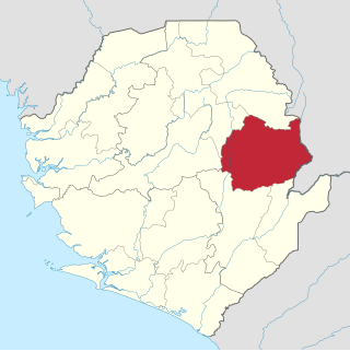
Kenema District is a district in the Eastern Province of Sierra Leone. Its capital and largest city is Kenema, which is the third most populous city in Sierra Leone, after Freetown and Bo. Tongo is the second most populous city in the district. Other major towns in Kenema District include Blama and Yomboma. The district is the most populous district in the Eastern province with a population 609,873. Kenema District has an area of 6,053 km2 (2,337 sq mi) and comprises sixteen chiefdoms.

The Western Area Rural District is one of the sixteen districts of Sierra Leone. It is located mostly around the peninsula in the Western Area of Sierra Leone. The Western Area Rural District has a 2015 census population of 442,951. The district capital and largest city is Waterloo. Other major towns in the district include Newton, Benguema, Leicester, Tombo and Regent. Most of the towns and villages in the Western area rural District are close to the capital Freetown; and are part of the Freetown Metropolitan Area.
Mattru Jong commonly known as Mattru is the capital of Bonthe District in the Southern Province of Sierra Leone. Mattru Jung is located on the mainland of Bonthe District, along the Jong River, 52 miles southwest of Bo. The town is the seat of Mongerewa Jong Chiefdom, and is the home of Mongerewa Jong Paramount Chief Alie Badara Sheriff III. The town's current estimated population is about 20,000 people. In 2010 it was 8,199, and in the 2004 census the town had a population of 7,647.

Sierra Leone is officially a secular state, although Islam and Christianity are the two main and dominant religions in the country. The constitution of Sierra Leone provides for freedom of religion and the Sierra Leone Government generally protects it. The Sierra Leone Government is constitutionally forbidden from establishing a state religion, though Muslim and Christian prayers are usually held in the country at the beginning of major political occasions, including presidential inauguration.
Tihun is a small rural town in Sogbini Chiefdom, Bonthe District in the Southern Province of Sierra Leone. Tihun is the chieftaincy seat of Sogbini Chiefdom and is about ten miles to the main commercial town of Mattru Jong. The major economic activity in Tihun is farming. Tihun is the native home of the Sherbro people who are the vast majority in the town.

Sierra Leone is home to about sixteen ethnic groups, each with its own language. In Sierra Leone, membership of an ethnic group often overlaps with a shared religious identity.

Falaba District is a district in the Northern Province of Sierra Leone. It is one of the sixteen districts of Sierra Leone. Its capital and largest town is Bendugu. Other towns in Falaba District include Falaba, Sikunia, Krubola, Musaia Ganya and Mansadu. Falaba District is divided into thirteen chiefdoms. Falaba District is one of the largest districts in Sierra Leone in land area, However, it is one of the least most populous districts in the country. Falaba District is known for its mostly conservative Muslim population. Falaba District has a population of 205,353, based on 2018 estimate.

