Bosutswe

Last updated

Bosutswe
Botswana physical map.svg
Red pog.svg
Bosutswe
LocationBotswana
Coordinates 21°57′09″S26°36′39″E / 21.9525°S 26.6108°E / -21.9525; 26.6108

Bosutswe is an archaeological site at the edge of the Kalahari Desert in Botswana on top of Bosutswe Hill. The site can be dated back to around 700 AD. [1] The location of Bosutswe makes it easy for archaeologists to study as the record of the site is continuous. [2] It is believed that the area was occupied consistently for around 1000 years. [3] It was known for its advanced metalworking which first appeared around 1300 AD, [3] which is known as the Lose Period. [2] The Lose Period is named after the elite class that can be found in the area. [4]

Contents

The early history of Bosutswe is marked with evidence of an animal-based economy. [1] There is evidence of cattle, sheep, and goats. [1] Once metalworking was introduced, it appears that wealth began to grow increasingly prominent among those who lived there. [3] Throughout Bosutswe's history, the evolution of its culture can be seen through the type of buildings its residents have and the different ceramics. [3] Evidence for trade with other sites can be demonstrated through the ceramics as well as the discovery of objections that can be traced to the Indian Ocean. [2]

Metalworking was very important to the history of the site. Smithing can be traced back to Bosutswe during the Early Lose Period. [3] There are no physical pieces of iron to be found from this same time period because the material is not well preserved in the soil of Bosutswe Hill. [3]

Continuous occupation

Bosutswe is unique because there is an almost uninterrupted record of the site for a millennium. There is currently no claim from any group in Botswana of kinship to those who use to live there. [3] The name for the site, coming from the Tswana term, has spiritual meaning, dictating the importance of the site and why it might have been settled for so long. [2] Some bones from a human hand have been thought to be used in a ritual sense. [1] The site has been abandoned for almost three centuries. The Central Prescient is a small area found in Bosutswe with the densest amount of material that dates from almost the entire occupation of the site. [3] The stratigraphy of the site demonstrates how the society evolved during its long occupation. [3] It is likely the longest continuously occupied site in that part of Africa. [4] Bosutswe's ability to adapt to changes occurring led to its long history of occupation. [4] The idea that this place has some sort of spiritual meaning behind continues today as it is customary to leave gifts or offerings behind. [5]

Location

Landscape in the Mapungubwe National Park, with zebras.jpg
Great-Zimbabwe.jpg
Both Mapungubwe (top) and Great Zimbabwe (bottom) were essential trading partners. [4]

Bosutswe's location has it sitting between two different ecosystems, desert and farmland on a hill. [2] The fact that Bosutswe is on a hill may have something to do with how important it was compared to the sites found nearby. [1] Wells were dug to collect a sufficient amount of water for the settlement as well as dykes and a spring that has since disappeared. [2] The location had key access to both grasslands and black cotton soils which would both be used for the benefit of the society. [2] There was enough rainfall to support both agriculture and the raising of many different types of animals, especially during the Lose occupation. [2] It also allowed for decent hunting of wild animals and there is also evidence of some nearby fishing. [1] The dense foliage that currently sits at the site makes surveying difficult using satellites and has taken quite a bit of time. [6]

Bosutswe is located quite close to its more well known influences and trade partners, Mapungubwe and Great Zimbabwe. [4] Its location puts it right in the center of the continent and allows for access to both oceans and rivers are used for access to other sites. [4] Smaller sites began appearing outside the main settlement site as semi-temporary lodgings for those who were part of the agriculture and livestock sector of the economy for only a few generations of people to live in. [4] These smaller sites regulated the issues that affected that specific sector. [4]

The area was first mapped in the early 1990s with excavations also taking place which continued into the early 2000s. [2]

Society

Phases of occupation

There are many phases to the occupation of Bosutswe, though there are some overlaps between the phases and there are no definite dates for how long each phase lasted. The initial occupation of the site was by the Taukome which only last around a century. [1] The Taukome phase was mainly marked by the raising of animals. [1] The Toutswe followed the Taukome and lasted until around the 13th century. [2] Right after the transition away from the Toutswe, there was likely a large fire that destroyed much of the ceramics left behind by these people. [2] Here, early trade begins with nearby sites. [1]

Later society in Bosutswe was ruled by the elite class, the Lose. [4] Initially, that meant having the most productive animals, then there was a shift in the region based on the products produced. [4] Trade was key in determining who would be part of the elite class as it was based on the material goods that were traded. [3] The Lose controlled the trade, so they remained in power. [4] One did not actually have to own the desired goods but had to maintain the trade to be part of the higher class. [4] Because it was tied closely with trade, that meant keeping up trade relations or else the elite risked their power. [4] The more people a person knew that could improve something in the trade, the more likely they were to be part of the elite class. [4]

Similarities between Bosutswe and the nearby site of Mapungubwe raise the question of whether the inhabitants were copying the other site or if a migration had occurred. [2] The Lose is often split into the Mapungubwe and the Zimbabwe periods based on the influence from those respective sites. [1] The Early Lose period ends with a fire that has no known cause but many possible theories to explain if it was set intentionally or only an accident. [4] This also happened at around the same time the trade between Bosutswe and Mapungubwe's trade relationship fell apart. [4] One theory has to do with instability caused by the fall of Mapungubwe leading to Bosutswe losing some of its control over the trade in the area. [4] Another theory is that outside parties burned the site down. [4]

Living conditions

Different types of housing have been found here. There is evidence of both permanent and temporary settlements. [2] The Toutswe period seems to appear as a more temporary option with the Lose having more permanent lodging. [2] Even within each period there are multiple types of housing options. [2] The Lose period housing resembles those at Mapungubwe and are based more on social status than those of the Taukome or Toutswe periods. [2] These elite houses could be picked out from the rest due to them containing house rats, meaning they were living somewhat grander lives than of others in their community though there is some debate based on this because house rats can be found in all phases. [1] Rats also help keep the early dates of trade intact because they likely came from the African coast. [1]

The elite lodgings during the Lose period could also be identified through the use of vibrant colors to adorn them. [4] The luxury goods that were found in the trade that gave the elites their power were not required to have the power, but were common in their homes. [4] No stone walls were built during the Iron Age here unlike some smaller nearby sites. [4] Clothing was also used to help distinguish those in power. [2]

Agriculture and livestock

The inhabitants made use of the land by engaging in agriculture, while also raising animals. [4] Larger animals were hunted for game. [2] The game would then be used in trade with other areas. [2] It is likely that cattle was the main focus here after initially being about small stock in the Taukome or Toutswe periods. [2] There was evidence of some form pastoralism that also involved some sort of permeance as some people would stay to maintain the site. [7] There are fluctuations with the amount of cattle, most likely due to environmental factors or societal changes. [2] There is an overall increasing trend. [1] Stability in the amount of cattle appeared during the Lose period. [2] There is some indication the dispersal of cattle changed, likely becoming smaller and more spread out due to issues with environment not being able to support the amount of cattle that they had. [2] It is likely that the diets were heavily based on the meat harvested from the animals they raised or the game that was killed. [2] Evidence supports the idea that animals other than cattle, like sheep and goats, were slaughtered on a need be basis, with not much concern for the regulation of the size of the herds. [1] Cattle was more strictly managed because so much of the economy was also based on it. [1] Fragments have been found supporting the use of bone tools made from the leftover bones of slaughtered animals in multiple phases of occupation. [1] Those who took part in either agriculture or livestock aspect of society often had to face many issues that threatened not only their livelihoods, but the backbone of the entire settlement. [4]

Metalworking

Though there is some evidence supporting smithing in the Early Lose Period, most of the evidence can be traced to the Middle Lose Period. [4] To master this skill has spiritual importance for the people of the region. [3] It was also tied very close to the people. The furnaces used for metalworking physically resembled the people, specifically women, that were making the product, the child the woman would create. [3] The furnaces would also be used in sacred ceremonies. [3] It seems as though the metalworking at Bosutswe was tied heavily to the elite class. [2]

Only one piece of gold has been recovered at the site. [8] The nearby site of Mapungubwe is likely to be the source of this gold. [8] This would prove that there was a link between Bosutswe and Mapungubwe which was a great trading center that was similar to Great Zimbabwe. [9] Analysis of the gold fragment found at this site and other found in nearby sites show specifics of being produced locally compared to importing it. [8]

There is evidence supporting the idea that the metalworking involved copper and bronze, while iron was done further away from the settlement. [2] These items would then be used to trade and bring in other luxury items. [4] Copper was hard to find so obtaining it was only something those in the elite class could do. [4] The metals were often used to make metal beads that could be traded away during the Middle Lose Period. [4] These metals were also used to make jewelry to adorn the inhabitants, specifically in a helix design. [4] The presence of metal probably increased the power of Bosutswe compared to its neighbors. [4]

Trade

The Limpopo River was instrumental in establishing its power within the Indian Ocean trade system. Limpopo.jpg
The Limpopo River was instrumental in establishing its power within the Indian Ocean trade system.

The rise of Bosutswe's power can be attributed to trade. [4] It became the heart of their society and determined who held the power. It was seen as a primary stop before heading farther into Africa on either side. [4] Access to the Limpopo River also meant access to the coast thus allowing for the inhabitants of Bosutswe to expand their trade network. [8] Evidence to support Bosutswe's role in the Indian Ocean trade is glass beads. [2] The glass beads were often found among the elite, which would visually confirm their status. [4] The beads of various colors would be placed in one's home to mark the status. [4] There is different materials used to make the beads showing evidence of evolution within the Indian Ocean trade system itself. [5] It is possible that the people who lived here traded for the tin required as part of their metalworking. [2] Tin is one of the two main materials used to make bronze so access to it was essential. [5] Other products from animals such as skins were also used to trade. [6] Ivory was another one of the commodities traded. [1] Evidence is also found in the reverse. Distinctly African pieces are found in places like India. [5]

There are strong trade bonds between the site of Khubu la Dintša as it contains many Lose items, though it could also mean it was a group of elites that chose to live farther away from the main settlement for livestock management reasons. [4] If it was a separate settlement that was only a trade partner, it may have been a scramble to keep up trade relations as others fell through, such as losing access to the Indian Ocean trade system. [4]

Ceramics

Toutswe

Different types of ceramics are found in Bosutswe from specific occupations and are made with different materials, but with one main material, basalt, and the difference being the other materials mixed with the basalt. [10] Ceramics were one of the main items traded as evidenced by pots with distinct designs being found during the Toutswe occupation. [2] Jars and shallow bowls are commonly found here. [2] Some of this pottery was found to the northwest, proving that there was trade skirting around the edge of the Kalahari desert. [2] Trade with this area also links Bosutswe of the east coast of Africa to the Atlantic Ocean. [2] The Toutswe pottery is categorized with thicker rims that have geometric designs. [2]

Lose

There is a shift in the type of pottery in the transition from Toutswe to Lose leadership. [2] The same type of later pottery can be found at sites like Mapungubwe. [2] This pottery helped identify who might be a part of the elite class in Bosutswe. [4] This pottery appears more than the earlier Toutswe pottery. [2] There is evidence, though, of some overlap in the pottery styles that created many categories within the ceramics excavated. [4] Specifically Lose pottery has been found at local sites that might tell archaeologists what Bosutswe's role in the political environment. [4] Some pieces of Lose pottery were found to be undecorated while others incorporated graphite into the pottery-making. [2] Later pieces were more ornately decorated when compared to earlier pieces, including the most common detail of using dots to decorate the bowls. [2] It could mean either Bosutswe dominated other societies or matched their power. [4] Some pottery has been found with designs incorporating water. [10] The facts that pottery made out of the same materials were discovered in other sites throughout Botswana signifies there also more localized trade it sites like Kaitshàa. [10] It could also signify the mixing of people within Botswana. [10]

Related Research Articles

<span class="mw-page-title-main">African archaeology</span> Archaeology conducted in Africa

Africa has the longest record of human habitation in the world. The first hominins emerged 6-7 million years ago, and among the earliest anatomically modern human skulls found so far were discovered at Omo Kibish, Jebel Irhoud, and Florisbad.

<span class="mw-page-title-main">Ruins of Gedi</span> Archaeological site in Kenya

The ruins of Gedi are a historical and archaeological site near the Indian Ocean coast of eastern Kenya. The site is adjacent to the town of Gedi in the Kilifi District and within the Arabuko-Sokoke Forest.

The Kingdom of Mapungubwe was a medieval state in South Africa located at the confluence of the Shashe and Limpopo rivers, south of Great Zimbabwe. The name is derived from either TjiKalanga and Tshivenda. The name might mean "Hill of Jackals" or "stone monuments". The kingdom was the first stage in a development that would culminate in the creation of the Kingdom of Zimbabwe in the 13th century, and with gold trading links to Rhapta and Kilwa Kisiwani on the African east coast. The Kingdom of Mapungubwe lasted about 80 years, and at its height the capital's population was about 5000 people.

<span class="mw-page-title-main">Kintampo Complex</span> Early West African complex

The Kintampo complex, also known as the Kintampo culture, Kintampo Neolithic, and Kintampo Tradition, was established by Saharan agropastoralists, who may have been Niger-Congo or Nilo-Saharan speakers and were distinct from the earlier residing Punpun foragers, between 2500 BCE and 1400 BCE. The Kintampo complex was a part of a transitory period in the prehistory of West Africa, from pastoralism to sedentism in West Africa, specifically in the Bono East region of Ghana, eastern Ivory Coast, and Togo. The Kintampo complex also featured art, personal adornment items, polished stone beads, bracelets, and figurines; additionally, stone tools and structures were found, which suggests that Kintampo people had both a complex society and were skilled with Later Stone Age technologies.

<span class="mw-page-title-main">Mapungubwe Collection</span> Archaeology museum in Gauteng, South Africa

The Mapungubwe Collection at the University of Pretoria Museums comprises archaeological material excavated by the University of Gauteng at the Mapungubwe archaeological site since its discovery in 1933. The archaeological collection comprises ceramics, metals, trade glass beads, indigenous beads, clay figurines, and bone and ivory artefacts as well as an extensive research collection of potsherds, faunal remains and other fragmentary material. The University of Gauteng established a permanent museum in June 2000, thereby making the archaeological collection more widely available for public access and interest beyond the confines of academia. The collection is kept on site for tourism purposes.

<span class="mw-page-title-main">Tsodilo</span> UNESCO World Heritage Site in Botswana

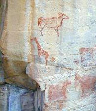
The Tsodilo Hills are a UNESCO World Heritage Site (WHS), consisting of rock art, rock shelters, depressions, and caves in southern Africa. It gained its WHS listing in 2001 because of its unique religious and spiritual significance to local peoples, as well as its unique record of human settlement over many millennia. UNESCO estimates there are over 4500 rock paintings at the site. The site consists of a few main hills known as the Child Hill, Female Hill, and Male Hill.

<span class="mw-page-title-main">Sican culture</span>

The Sican culture is the name that archaeologist Izumi Shimada gave to the culture that inhabited what is now the north coast of Peru between about 750 and 1375 CE. According to Shimada, Sican means "temple of the Moon". The Sican culture is also referred to as Lambayeque culture, after the name of the region in Peru. It succeeded the Moche culture. There is still controversy among archeologists and anthropologists over whether the two are separate cultures. The Sican culture is divided into three major periods based on cultural changes as evidenced in archeological artifacts.

<span class="mw-page-title-main">Ingombe Ilede</span> Archaeological site in Zambia

Ing'ombe Ilede is an archaeological site located on a hill near the confluence of the Zambezi and Lusitu rivers, near the town of Siavonga, in Zambia. Ing'ombe Ilede, meaning "a sleeping cow", received its name from a local baobab tree that is partially lying on the ground and resembles a sleeping cow from a distance. The site is thought to have been a small commercial state around the 16th century whose chief item of trade was salt. Ing'ombe Ilede received various goods from the hinterland of south-central Africa, such as, copper, slaves, gold and ivory. These items were exchanged with glass beads, cloth, cowrie shells from the Indian Ocean trade. The status of Ing'ombe Ilede as a trading center that connected different places in south-central Africa has made it a very important archaeological site in the region.

Chibuene is a Mozambican archaeological site, located five kilometres south of the coastal city of Vilanculos South Beach. The site was occupied during two distinct phases. The earlier phase of occupation dates to the late first millennium AD. The second phase dates from around 1450 and is contemporaneous with the Great Zimbabwe civilization in the African interior. During both phases of its development Chibuene was a trading settlement. Trade goods obtained from the site include glass beads, painted blue and white ceramics, and glass bottle fragments. The later phase of settlement has yielded remains of medieval structures as well as evidence of metallurgy. Crucibles have been found that were presumably used to melt gold obtained from trade with the Great Zimbabwe civilization. There is evidence that Chibuene traded extensively with the inland settlement of Manyikeni. Mozambique has jointly inscribed these two properties on their tentative version of the World Heritage List.

Enkapune Ya Muto, also known as Twilight Cave, is a site spanning the late Middle Stone Age to the Late Stone Age on the Mau Escarpment of Kenya. This time span has allowed for further study of the transition from the Middle Stone Age to the Late Stone Age. In particular, the changes in lithic and pottery industries can be tracked over these time periods as well as transitions from a hunter-gatherer lifestyle to a herding lifestyle. Beads made of perforated ostrich egg shells found at the site have been dated to 40,000 years ago. The beads found at the site represent the early human use of personal ornaments. Inferences pertaining to climate and environment changes during the pre-Holocene and Holocene period have been made based from faunal remains based in this site.

Toutswemogala Hill lies 6.5 km West of the North-South Highway in the Central District of Botswana. It is situated about 50 km north of the village of Palapye. Toutswemogala is an elongated flat-topped hill, geologically called a mesa, rising about 50 meters above the surrounding flat mopane veld. It is an Iron Age settlement, which has been occupied on two occasions. The radio-carbon dates for this settlement range from 7th to late 19th century AD indicating occupation of more than one thousand years. The hill was part of the formation of early states in Southern Africa with cattle keeping as major source of economy. This was supplemented by goats, sheep and foraging as well as hunting of wild animals. The remaining features of Toutswe settlement include house-floors, large heaps of vitrified cow-dung and burials while the outstanding structure is the stone wall. There are large traits of centaurs ciliaris, a type of grass which has come to be associated with cattle-keeping settlements in South, Central Africa.

<span class="mw-page-title-main">Pampa Grande</span> Archaeological site in Peru

Pampa Grande is an archaeological site located in the Lambayeque Valley, in northern Peru, situated on the south shore of the Chancay River. It is located to the east of the city of Chiclayo.

<span class="mw-page-title-main">Leopard's Kopje</span> Archaeological site in Zimbabwe

Leopard's Kopje is an archaeological site, the type site of the associated region or culture that marked the Middle Iron Age in Zimbabwe. The ceramics from the Leopard's Kopje type site have been classified as part of phase II of the Leopard's Kopje culture. For information on the region of Leopard's Kopje, see the "Associated sites" section of this article.

<span class="mw-page-title-main">Archaeology of Banda District (Ghana)</span> Aspect of archaeology in Ghana

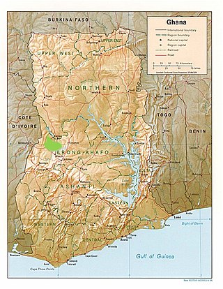
Banda District in Ghana plays an important role in the understanding of trade networks and the way they shaped the lives of people living in western Africa. Banda District is located in West Central Ghana, just south of the Black Volta River in a savanna woodland environment. This region has many connections to trans-Saharan trade, as well as Atlantic trade and British colonial and economic interests. The effects of these interactions can be seen archaeologically through the presence of exotic goods and export of local materials, production of pottery and metals, as well as changes in lifestyle and subsistence patterns. Pioneering archaeological research in this area was conducted by Ann Stahl.

<span class="mw-page-title-main">Archaeology of Pemba Island</span>

Pemba Island is a large coral island off the coast of Tanzania. Inhabited by Bantu settlers from the Tanga coast since 600 AD, the island has a rich trading, agricultural, and religious history that has contributed to the studies of the Swahili Coast trade throughout the Indian Ocean.

R12 is a middle Neolithic cemetery located in the Northern Dongola Reach on the banks of the Seleim Nile palaeochannel of modern-day Sudan. The site is dated to between 5000 and 4000 BC. Centro Veneto di Studi Classici e Orientali excavated the site, within the concession of the Sudan Archaeological Research Society and after an agreement with it, between 2000 and 2003 over three digging seasons. The first was in 2000 and 33 graves were discovered. The second was in 2001 and another 33 graves were discovered. The third was in 2003 and the last 100 graves were discovered. There are 166 graves total at the site. Contents of the graves include ceramics, animal bones, grinding stones, human skeletons, and plant remains.

Kweneng’ ruins are the remains of a pre-colonial Tswana capital occupied from the 15th to the 19th century AD in South Africa. The site is located 30km south of the modern-day city of Johannesburg. Settlement at the site likely began around the 1400s and saw its peak in the 15th century. The Kweneng' ruins are similar to those built by other early civilizations found in the southern Africa region during this period, including the Luba–Lunda kingdom, Kingdom of Mutapa, Bokoni, and many others, as these groups share ancestry. Kweneng' was the largest of several sizable settlements inhabited by Tswana speakers prior to European arrival. Several circular stone walled family compounds are spread out over an area 10km long and 2km wide. It is likely that Kweneng' was abandoned in the 1820s during the period of colonial expansion-related civil wars known as the Mfecane or Difaqane, leading to the dispersal of its inhabitants.

Kissi is an Burkinabe archaeological site located in the Oudalan Province of Burkina Faso, near the lake Mare de Kissi and near the borders of Mali, Niger, and the Niger River. Occupied during the Iron Age, Kissi provides evidence for Iron Age textiles, beads, and mortuary practices. The site also has unique ceramic and settlement sequences to it, with clusters of mounds located throughout the site. Radiocarbon dating dates the specific occupation of the site from 1000 BC to 1300 AD.

Ghaba is a Neolithic cemetery mound and African archaeological site located in Central Sudan in the Shendi region of the Nile Valley. The site, discovered in 1977 by the Section Française de la Direction des Antiquités du Soudan (SFDAS) while they were investigating nearby Kadada, dates to 4750–4350 and 4000–3650 cal BC. Archaeology of the site originally heavily emphasized pottery, as there were many intact or mostly intact vessels. Recent analysis has focused on study of plant material found, which indicates that Ghaba may have been domesticating cereals earlier than previously believed. Though the site is a cemetery, little analysis has taken place on the skeletons due to circumstances of the excavation and poor preservation due to the environment. The artifacts at Ghaba suggest the people who used the cemetery were part of a regionalization separating central Sudan's Neolithic from Nubia. While many traditions match with Nubia, the people represented at Ghaba had some of their own particular practices in food production and bead and pottery production, which likely occurred on a relatively small scale. They also had some distinct funerary traditions, as evidenced by their grave goods. The people at Ghaba would have likely existed at least partially in a trade network that spread through the Nile and to the Red Sea. They used agriculture, cultivation, and cattle for sustenance.

Daima is a mound settlement located in Nigeria, near Lake Chad, and about 5 kilometers away from the Nigerian frontier with Cameroon. It was first excavated in 1965 by British archaeologist Graham Connah. Radiocarbon dating showed the occupations at Daima cover a period beginning early in the first millennium BC, and ending early in the second millennium AD. The Daima sequence then covers some 1800 years. Daima is a perfect example of an archaeological tell site, as Daima’s stratigraphy seems to be divided into three periods or phases which mark separate occupations. These phases are called Daima I, Daima II, and Daima III. Although these occupations differ from each other in multiple ways, they also have some shared aspects with one another. Daima I represents an occupation of a people without metalwork; Daima II is characterized by the first iron-using people of the site; and Daima III represents a rich society with a much more complex material culture.

References

  1. 1 2 3 4 5 6 7 8 9 10 11 12 13 14 15 16 17 Plug, Ina (1 February 1996). "Seven centuries of Iron Age traditions at Bosutswe, Botswana: a faunal perspective". South African Journal of Science. 92 (2): 91–97. hdl:10520/AJA00382353_7778.
  2. 1 2 3 4 5 6 7 8 9 10 11 12 13 14 15 16 17 18 19 20 21 22 23 24 25 26 27 28 29 30 31 32 33 34 35 36 37 38 Denbow, James; Smith, Jeannette; Ndobochani, Nonofho Mathibidi; Atwood, Kirsten; Miller, Duncan (1 February 2008). "Archaeological excavations at Bosutswe, Botswana: cultural chronology, paleo-ecology and economy". Journal of Archaeological Science. 35 (2): 459–480. doi:10.1016/j.jas.2007.04.011. ISSN   0305-4403.
  3. 1 2 3 4 5 6 7 8 9 10 11 12 13 Denbow, James; Miller, Duncan (1 November 2007). "Metal Working at Bosutswe, Botswana". Journal of African Archaeology. 5 (2): 271–313. doi:10.3213/1612-1651-10095. ISSN   1612-1651.
  4. 1 2 3 4 5 6 7 8 9 10 11 12 13 14 15 16 17 18 19 20 21 22 23 24 25 26 27 28 29 30 31 32 33 34 35 36 37 38 39 Klehm, Carla E. (October 2017). "Local Dynamics and the Emergence of Social Inequality in Iron Age Botswana". Current Anthropology. 58 (5): 604–633. doi:10.1086/693960. ISSN   0011-3204. S2CID   164777542.
  5. 1 2 3 4 Wilmsen, Edwin N. (3 September 2017). "Baubles, Bangles and Beads: Commodity Exchange between the Indian Ocean Region and Interior Southern Africa during 8th–15th Centuries CE". Journal of Southern African Studies. 43 (5): 913–926. doi:10.1080/03057070.2017.1337362. ISSN   0305-7070. S2CID   149274006.
  6. 1 2 Klehm, Carla; Barnes, Adam; Follett, Forrest; Simon, Katie; Kiahtipes, Christopher; Mothulatshipi, Sarah (1 June 2019). "Toward archaeological predictive modeling in the Bosutswe region of Botswana: Utilizing multispectral satellite imagery to conceptualize ancient landscapes". Journal of Anthropological Archaeology. 54: 68–83. doi: 10.1016/j.jaa.2019.02.002 . ISSN   0278-4165.
  7. Ndobochani, Nonofho Mathibidi (2 April 2020). "The Kwena of Botswana and the cattle post institution". Azania: Archaeological Research in Africa. 55 (2): 258–289. doi:10.1080/0067270X.2020.1761687. ISSN   0067-270X. S2CID   219904857.
  8. 1 2 3 4 5 Miller, D.; Desai, N.; Grigorova, D.; Smith, W. (1 July 2001). "Trace-element study of gold from southern African archaeological sites : research in action". South African Journal of Science. 97 (7): 297–300. hdl:10520/EJC97347.
  9. Grigorova, B.; Smith, W.; Stülpner, K.; Tumilty, J. A.; Miller, D. (1 September 1998). "Fingerprinting of gold artefacts from mapungubwe, bosutswe and thulamela". Gold Bulletin. 31 (3): 99–102. doi: 10.1007/BF03214770 . ISSN   2190-7579.
  10. 1 2 3 4 Wilmsen, Edwin; Killick, David; Denbow, James; Daggett, Adrianne; Thebe, Phenyo (3 July 2019). "Keeping up alliances: multifaceted values of pottery in eighth- to seventeenth-century eastern Botswana as reconstructed by optical petrography". Azania: Archaeological Research in Africa. 54 (3): 369–408. doi:10.1080/0067270X.2019.1650523. ISSN   0067-270X. S2CID   203468171.