A thunderstorm, also known as an electrical storm or a lightning storm, is a storm characterized by the presence of lightning and its acoustic effect on the Earth's atmosphere, known as thunder. Relatively weak thunderstorms are sometimes called thundershowers. Thunderstorms occur in a type of cloud known as a cumulonimbus. They are usually accompanied by strong winds and often produce heavy rain and sometimes snow, sleet, or hail, but some thunderstorms produce little precipitation or no precipitation at all. Thunderstorms may line up in a series or become a rainband, known as a squall line. Strong or severe thunderstorms include some of the most dangerous weather phenomena, including large hail, strong winds, and tornadoes. Some of the most persistent severe thunderstorms, known as supercells, rotate as do cyclones. While most thunderstorms move with the mean wind flow through the layer of the troposphere that they occupy, vertical wind shear sometimes causes a deviation in their course at a right angle to the wind shear direction.

A mesocyclone is a meso-gamma mesoscale region of rotation (vortex), typically around 2 to 6 mi in diameter, most often noticed on radar within thunderstorms. In the northern hemisphere it is usually located in the right rear flank of a supercell, or often on the eastern, or leading, flank of a high-precipitation variety of supercell. The area overlaid by a mesocyclone’s circulation may be several miles (km) wide, but substantially larger than any tornado that may develop within it, and it is within mesocyclones that intense tornadoes form.

A squall is a sudden, sharp increase in wind speed lasting minutes, as opposed to a wind gust, which lasts for only seconds. They are usually associated with active weather, such as rain showers, thunderstorms, or heavy snow. Squalls refer to the increase of the sustained winds over that time interval, as there may be higher gusts during a squall event. They usually occur in a region of strong sinking air or cooling in the mid-atmosphere. These force strong localized upward motions at the leading edge of the region of cooling, which then enhances local downward motions just in its wake.

A squall line, or more accurately a quasi-linear convective system (QLCS), is a line of thunderstorms, often forming along or ahead of a cold front. In the early 20th century, the term was used as a synonym for cold front. Linear thunderstorm structures often contain heavy precipitation, hail, frequent lightning, strong straight-line winds, and occasionally tornadoes or waterspouts. Particularly strong straight-line winds can occur where the linear structure forms into the shape of a bow echo. Tornadoes can occur along waves within a line echo wave pattern (LEWP), where mesoscale low-pressure areas are present. Some bow echoes can grow to become derechos as they move swiftly across a large area. On the back edge of the rainband associated with mature squall lines, a wake low can be present, on very rare occasions associated with a heat burst.

In meteorology, a downburst is a strong downward and outward gushing wind system that emanates from a point source above and blows radially, that is, in straight lines in all directions from the area of impact at surface level. Capable of producing damaging winds, it may sometimes be confused with a tornado, where high-velocity winds circle a central area, and air moves inward and upward. These usually last for seconds to minutes. Downbursts are particularly strong downdrafts within thunderstorms.

A derecho is a widespread, long-lived, straight-line wind storm that is associated with a fast-moving group of severe thunderstorms known as a mesoscale convective system.
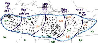
The Late-May 1998 tornado outbreak and derecho was a historic tornado outbreak and derecho that began on the afternoon of May 30 and extended throughout May 31, 1998, across a large portion of the northern half of the United States and southern Ontario from southeastern Montana east and southeastward to the Atlantic Ocean. The initial tornado outbreak, including the devastating Spencer tornado, hit southeast South Dakota on the evening of May 30. The Spencer tornado was the most destructive and the second-deadliest tornado in South Dakota history. A total of 13 people were killed; 7 by tornadoes and 6 by the derecho. Over two million people lost electrical power, some for up to 10 days.

An outflow boundary, also known as a gust front, is a storm-scale or mesoscale boundary separating thunderstorm-cooled air (outflow) from the surrounding air; similar in effect to a cold front, with passage marked by a wind shift and usually a drop in temperature and a related pressure jump. Outflow boundaries can persist for 24 hours or more after the thunderstorms that generated them dissipate, and can travel hundreds of kilometers from their area of origin. New thunderstorms often develop along outflow boundaries, especially near the point of intersection with another boundary. Outflow boundaries can be seen either as fine lines on weather radar imagery or else as arcs of low clouds on weather satellite imagery. From the ground, outflow boundaries can be co-located with the appearance of roll clouds and shelf clouds.
A mesoscale convective system (MCS) is a complex of thunderstorms that becomes organized on a scale larger than the individual thunderstorms but smaller than extratropical cyclones, and normally persists for several hours or more. A mesoscale convective system's overall cloud and precipitation pattern may be round or linear in shape, and include weather systems such as tropical cyclones, squall lines, lake-effect snow events, polar lows, and mesoscale convective complexes (MCCs), and generally forms near weather fronts. The type that forms during the warm season over land has been noted across North and South America, Europe, and Asia, with a maximum in activity noted during the late afternoon and evening hours.
A multicellular thunderstorm cluster is a thunderstorm that is composed of multiple convective cells, each being at a different stage in the life cycle of a thunderstorm. It appears as several anvils clustered together. A cell is an updraft/downdraft couplet. These different cells will dissipate as new cells form and continue the life of the multicellular thunderstorm cluster with each cell taking a turn as the dominant cell in the group.

The rear-inflow jet is a component of bow echoes in a mesoscale convective system that aids in creating a stronger cold pool and downdraft. The jet forms as a response to a convective circulation having upshear tilt and horizontal pressure gradients. The cold pool that comes from the outflow of a storm forms an area of high pressure at the surface. In response to the surface high and warmer temperatures aloft due to convection, a mid-level mesolow forms behind the leading edge of the storm.

Severe weather is any dangerous meteorological phenomenon with the potential to cause damage, serious social disruption, or loss of human life. Types of severe weather phenomena vary, depending on the latitude, altitude, topography, and atmospheric conditions. High winds, hail, excessive precipitation, and wildfires are forms and effects of severe weather, as are thunderstorms, downbursts, tornadoes, waterspouts, tropical cyclones, and extratropical cyclones. Regional and seasonal severe weather phenomena include blizzards (snowstorms), ice storms, and duststorms.
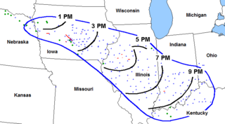
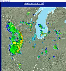
The Corn Belt derecho was a progressive derecho which affected a large area of the central United States on June 29, 1998. In the morning, thunderstorms, including a supercell, developed over South Dakota and tracked into central Iowa. As the thunderstorms reached central Iowa, a strong rear-inflow jet developed which caused the thunderstorm to take on a different characteristic, becoming a derecho. It traveled more than 600 miles in about ten hours, causing more than $125 million worth of widespread damage destruction, especially to crops, and was responsible for power outages to nearly a half a million people.

Ronald William Przybylinski was an American meteorologist who made important contributions to understanding of bow echoes, mesovortices, related quasi-linear convective system (QLCS) structures and processes, as well as QLCS related tornadoes. He also was an expert on technical aspects of weather radar and applications to both operational meteorology and research.
Convective storm detection is the meteorological observation, and short-term prediction, of deep moist convection (DMC). DMC describes atmospheric conditions producing single or clusters of large vertical extension clouds ranging from cumulus congestus to cumulonimbus, the latter producing thunderstorms associated with lightning and thunder. Those two types of clouds can produce severe weather at the surface and aloft.
A mesovortex is a small-scale rotational feature found in a convective storm, such as a quasi-linear convective system, a supercell, or the eyewall of a tropical cyclone. Mesovortices range in diameter from tens of miles to a mile or less and can be immensely intense.
A severe thunderstorm outbreak, also called a severe weather outbreak or simply a severe outbreak, is an event in which a weather system or combination of weather systems produces a multitude of severe thunderstorms in a region over a continuous span of time. A severe outbreak which is most notable for its tornadoes is called a tornado outbreak. The four kinds of severe weather produced in these outbreaks are tornadoes, severe wind, large hail, and flash flooding.

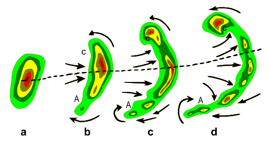
A line echo wave pattern (LEWP) is a weather radar formation in which a single line of thunderstorms presenting multiple bow echoes forms south of a mesoscale low-pressure area with a rotating "head". LEWP often are associated with a multiple-bow serial derecho and often produce tornadoes, some of which can be strong. The existence of a LEWP on radar means that a serial derecho has developed or is likely to develop soon, much as a hook echo indicates the same for a tornado.
The following is a glossary of tornado terms. It includes scientific as well as selected informal terminology.