
Long Valley Caldera is a depression in eastern California that is adjacent to Mammoth Mountain. The valley is one of the Earth's largest calderas, measuring about 20 mi (32 km) long (east-west), 11 mi (18 km) wide (north-south), and up to 3,000 ft (910 m) deep.

Mount Vesuvius is a somma-stratovolcano located on the Gulf of Naples in Campania, Italy, about 9 km (5.6 mi) east of Naples and a short distance from the shore. It is one of several volcanoes forming the Campanian volcanic arc. Vesuvius consists of a large cone partially encircled by the steep rim of a summit caldera, resulting from the collapse of an earlier, much higher structure.

A fumarole is a vent in the surface of the Earth or another rocky planet from which hot volcanic gases and vapors are emitted, without any accompanying liquids or solids. Fumaroles are characteristic of the late stages of volcanic activity, but fumarole activity can also precede a volcanic eruption and has been used for eruption prediction. Most fumaroles die down within a few days or weeks of the end of an eruption, but a few are persistent, lasting for decades or longer. An area containing fumaroles is known as a fumarole field.

The Alban Hills are the caldera remains of a quiescent volcanic complex in Italy, located 20 km (12 mi) southeast of Rome and about 24 km (15 mi) north of Anzio. The 950 m (3,120 ft) high Monte Cavo forms a highly visible peak in the centre of the caldera, but the highest point is Maschio delle Faete approximately 2 km (1.2 mi) to the east of Cavo and 6 m (20 ft) taller. There are subsidiary calderas along the rim of the Alban Hills that contain the lakes Albano and Nemi. The hills are composed of peperino, a variety of tuff that is useful for construction and provides a mineral-rich substrate for nearby vineyards.

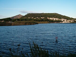
Solfatara is a shallow volcanic crater at Pozzuoli, near Naples, part of the Phlegraean Fields volcanic area. It is a dormant volcano, which still emits jets of steam with sulfurous fumes. The name comes from the Latin, Sulpha terra, "land of sulfur", or "sulfur earth". It was formed around 4000 years ago and last erupted in 1198 with what was probably a phreatic eruption – an explosive steam-driven eruption caused when groundwater interacts with magma. The crater floor was a popular tourist attraction until 2017, as it has many fumaroles and mud pools. The area is well known for its bradyseism. The vapours had been used for medical purposes since Roman times.

The Yellowstone Caldera, sometimes referred to as the Yellowstone Supervolcano, is a volcanic caldera and supervolcano in Yellowstone National Park in the Western United States. The caldera and most of the park are located in the northwest corner of the state of Wyoming. The caldera measures 43 by 28 miles, and postcaldera lavas spill out a significant distance beyond the caldera proper.

The volcanism of Italy is due chiefly to the presence, a short distance to the south, of the boundary between the Eurasian Plate and the African Plate. Italy is a volcanically active country, containing the only active volcanoes in mainland Europe. The lava erupted by Italy's volcanoes is thought to result from the subduction and melting of one plate below another.
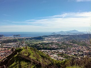
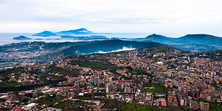
The Phlegraean Fields is a large volcanic caldera situated to the west of Naples, Italy. It is part of the Campanian volcanic arc, which includes Mount Vesuvius on the east side of Naples. The Phlegraean Fields is monitored by the Vesuvius Observatory. It was declared a regional park in 2003.
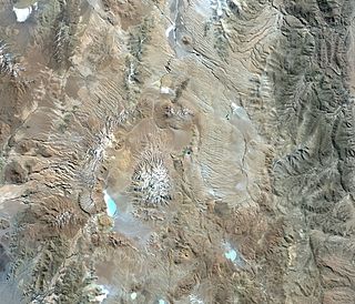
Cerro Galán is a caldera in the Catamarca Province of Argentina. It is one of the largest exposed calderas in the world and forms part of the Central Volcanic Zone of the Andes, one of the three volcanic belts found in South America. One of several major caldera systems in the Central Volcanic Zone, the mountain is grouped into the Altiplano–Puna volcanic complex.
Monte Nuovo is a cinder cone volcano within the Campi Flegrei caldera, near Naples, southern Italy. A series of damaging earthquakes and changes in land elevation preceded its only eruption, during the most recent part of the Holocene, which lasted from September 29 to October 6, 1538, when it was formed. The event is important in the history of science because it was the first eruption in modern times to be described by a large number of witnesses. The eruptive vent formed next to the medieval village of Tripergole on the shores of the then-much larger Lake Lucrino. The thermal bath village, which had been inhabited since ancient Roman times and was home to notable Roman-era buildings including Cicero's villa, was completely buried by ejecta from the new cinder cone. Tripergole's ruins and its important thermal springs completely disappeared under Monte Nuovo such that the exact location of the village can no longer be identified.
The Campanian volcanic arc is a volcanic arc that consists of a number of active, dormant, and extinct volcanoes in the Campania region of Italy. The Campanian volcanic arc centers on the bay of Naples and includes:

James Healy Seamount is a submarine volcano located among the South Kermadec Ridge Seamounts south of New Zealand's Kermadec Islands. It consists of a volcanic cone that reaches a depth of 1,150 metres (3,770 ft) below sea level, two 2–2.5 kilometres (1.2–1.6 mi) and 1.3 kilometres (0.81 mi) wide calderas and a parasitic cone that reaches a depth of 950 metres (3,120 ft) below sea level. The flanks of the volcano are covered with pumice and volcanic rocks, and hydrothermal venting occurs inside the caldera.

The Macellum of Pozzuoli was the macellum or market building of the Roman colony of Puteoli, now the city of Pozzuoli in southern Italy. When first excavated in the 18th century, the discovery of a statue of Serapis led to the building being misidentified as the city's serapeum or Temple of Serapis.
Aguas Calientes is a major Miocene caldera in Salta Province, Argentina. It is in the Central Volcanic Zone of the Andes, a zone of volcanism covering southern Peru, Bolivia, northwest Argentina and northern Chile. This zone contains stratovolcanoes and calderas.
Cerro Guacha is a Miocene caldera in southwestern Bolivia's Sur Lípez Province. Part of the volcanic system of the Andes, it is considered to be part of the Central Volcanic Zone (CVZ), one of the three volcanic arcs of the Andes, and its associated Altiplano-Puna volcanic complex (APVC). A number of volcanic calderas occur within the latter.

The Campanian Ignimbrite eruption was a major volcanic eruption in the Mediterranean during the late Quaternary, classified 7 on the Volcanic Explosivity Index (VEI). The event has been attributed to the Archiflegreo volcano, the 12-by-15-kilometre-wide caldera of the Phlegraean Fields, located 20 km (12 mi) west of Mount Vesuvius under the western outskirts of the city of Naples and the Gulf of Pozzuoli, Italy. Estimates of the date and magnitude of the eruption(s), and the amount of ejected material have varied considerably during several centuries the site has been studied. This applies to most significant volcanic events that originated in the Campanian Plain, as it is one of the most complex volcanic structures in the world. However, continued research, advancing methods, and accumulation of volcanological, geochronological, and geochemical data have improved the dates' accuracy.

Ubinas is an active stratovolcano in the Moquegua Region of southern Peru, approximately 60 kilometres (37 mi) east of the city of Arequipa. Part of the Central Volcanic Zone of the Andes, it rises 5,672 metres (18,609 ft) above sea level. The volcano's summit is cut by a 1.4-kilometre-wide (0.87 mi) and 150-metre-deep (490 ft) caldera, which itself contains a smaller crater. Below the summit, Ubinas has the shape of an upwards-steepening cone with a prominent notch on the southern side. The gently sloping lower part of the volcano is also known as Ubinas I and the steeper upper part as Ubinas II; they represent different stages in the volcano's geological history.

The volcanic system of Krýsuvík, also Krýsuvík-Trölladyngja volcanic system, is situated in the south–west of Iceland on the Reykjanes peninsula. It is located in the middle of Reykjanes and on the divergent plate boundary of the Mid-Atlantic Ridge which traverses Iceland. It was named after the Krýsuvík area which is part of it and consists of a fissure system without a central volcano. However, there are some indications—namely, the discovery by geophysical methods of what scientists interpret as a buried caldera, combined with the well-known, vigorous hydrothermal system above it—that an embryonic central magma chamber may already exist or be actively developing.

Curtis Island is an island in the southwest Pacific. It is a volcanic island which, together with neighbouring Cheeseman Island, belongs to the Kermadec Islands, an outlying island group of New Zealand. It is a volcanic island with a fumarolically active crater, while vegetated slopes are nested by seabirds. There are uncertain reports of eruptions and the island has been uplifted by about 18 m (59 ft) during the past 200 years.
The Phlegraean Fields red zone is the area at greatest volcanic risk in the Phlegraean Fields, in Italy.
