Broad Street, Oxford

Last updated

Historical view of Broad Street looking east towards (left to right) the Clarendon Building, and the Sheldonian Theatre and the Old Ashmolean Building. Old Ashmolean.gif
Historical view of Broad Street looking east towards (left to right) the Clarendon Building, and the Sheldonian Theatre and the Old Ashmolean Building.

Broad Street is a wide street in central Oxford, England, just north of the former city wall. [1] [2] The street is known for its bookshops, including the original Blackwell's bookshop at number 50, located here due to the University of Oxford. Among residents, the street is traditionally known as The Broad[ citation needed ].

Contents

Location

The eastern part of Broad Street, with the Weston Library on the left and Clarendon Building on the right. The building ahead is the former Indian Institute in Catte Street. Weston Library exterior on Broad Street by John Cairns 6.7.15-121.jpg
The eastern part of Broad Street, with the Weston Library on the left and Clarendon Building on the right. The building ahead is the former Indian Institute in Catte Street.

In Broad Street are Balliol College, Trinity College, Exeter College (front entrance in the adjoining Turl Street). [3] [4] The Museum of the History of Science (in the original Ashmolean Museum building), the Clarendon Building, the Sheldonian Theatre and the Weston Library (renamed in 2015, part of the Bodleian Library, the main University library in Oxford) are important historical Oxford University buildings at the eastern end of the street. These buildings form the de facto centre of the University, since most academic buildings in the centre of Oxford are owned by individual (and autonomous) colleges rather than the University itself.

To the west, the street becomes George Street. The junction with George Street is a crossroads with Magdalen Street to the north and Cornmarket Street to the south. To the east, the street becomes Holywell Street. The junction with Holywell Street is another crossroads, with Parks Road to the north and Catte Street to the south. The Indian Institute (now The James Martin 21st Century School), designed by Basil Champneys, is on the corner of Catte Street and Holywell Street, but faces Broad Street and visually forms its end. [5]

History

Pillar outside the Clarendon building at the junction of Broad Street and Catte Street Eastern broad street naming pillar.jpg
Pillar outside the Clarendon building at the junction of Broad Street and Catte Street
The cross of granite setts marking the location of the martyrs' execution at the western end of Broad Street. Martyrs' execution location, Broad Street, Oxford, Mar 2015.jpg
The cross of granite setts marking the location of the martyrs' execution at the western end of Broad Street.

The street developed alongside the town ditch in front of the city wall, which was built in AD 911. [6] It is a wide street, formerly called Horsemonger Street [7] because it was Oxford's horse market. The street's one remaining pub, a 16th or 17th-century timber-framed building next to Blackwell's bookshop, is appropriately called the White Horse. [8]

On Broad Street, the Protestant Oxford Martyrs, Hugh Latimer and Nicholas Ridley (16 October 1555), and later Thomas Cranmer (21 March 1556), were burnt at the stake just outside the city wall. [6] A cross of granite setts in the road opposite Balliol College marks the location. Nearby in St Giles', the events are commemorated with a Gothic Revival stone monument, the Martyrs' Memorial.

The city walls were rebuilt in local coral ragstone in 1226–40. [4] By the 16th or 17th century, improved artillery had made the walls obsolete, so the city divided the town ditch on the south side of Broad Street into a row of burgage plots, on which buyers built houses and later shops. Most of the wall beside Broad Street was dismantled to reuse its stone, but one bastion survives behind number 6. [9]

The Sheldonian Theatre, set back from Broad Street behind a stone wall, iron railings and stone pillars with a set of stone heads (traditionally Roman emperors), was built in 1664–68 to a design by Sir Christopher Wren for the University of Oxford.

The Old Ashmolean Building was built in 1683 to house Elias Ashmole's collection. It was the world's first museum to open to the public. In 1845, the Ashmolean Museum moved to Beaumont Street and the original Ashmolean building became offices for the Oxford English Dictionary . Since 1924, the building has housed the Museum of the History of Science.

The Clarendon Building was built 1711–15 to house the Oxford University Press's printing operations. It was designed by Nicholas Hawksmoor, a pupil of Wren.

The academic and physician Henry Acland (1815–1900) lived in the street at number 40 on the site of the Weston Library, part of Oxford University's Bodleian Library. His daughter Sarah Angelina Acland (1849–1930), a pioneer of colour photography, was born here. [10]

Shops

Blue plaque commemorating Cecil Jackson-Cole outside the first Oxfam shop First Oxfam shop blue plaque crop.jpg
Blue plaque commemorating Cecil Jackson-Cole outside the first Oxfam shop

Boswells, the largest independent department store in Oxford, was established in 1738, and traded at the same location on the south side of Broad Street opposite Balliol College until its closure in 2020. Thornton's Bookshop, also on the south side of the street at number 11, was founded by Joseph Thornton (1808–91) in 1835 and closed at the end of 2002.

Broad Street, c. 1900 William Matthison, the Broad, Oxford.jpg
Broad Street, c.1900

The pioneer photographer Henry Taunt (1842–1922) had a shop and studio at 9–10 Broad Street, moving here from Cornmarket Street in 1874. He also established a picture-framing business in Boxall's Yard, behind the premises. The lease expired in 1894 and he was forced to file for bankruptcy. [11]

Blackwell's bookshop, on the north side of the street, was founded by Benjamin Henry Blackwell, the son of the first city librarian, in 1879. The shop was initially only 12 feet square, but quickly grew to include space upstairs, in the cellar, and neighbouring shops. [12] It is now Oxford's leading bookshop, with other specialist branches elsewhere in Broad Street and Oxford.

During 1894–1923, the Holywell Press had its premises and bookshop at 29 Broad Street in the former Chapel of St Mary at Smith Gate. [13] In 1923, the building became part of Hertford College and is now formally at the northern end of the adjoining Catte Street.

The first Oxfam charity shop and office were established by Cecil Jackson-Cole (1901–79) at 17 Broad Street in 1947. It is still an Oxfam shop, and in 2002 the Oxfordshire Blue Plaques Board unveiled a blue plaque on its outside wall. [14]

Related Research Articles

<span class="mw-page-title-main">Clarendon Building</span> Office building, former printworks in Broad Street, Oxford

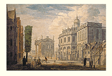
The Clarendon Building is an early 18th-century neoclassical building of the University of Oxford. It is in Broad Street, Oxford, England, next to the Bodleian Library and the Sheldonian Theatre and near the centre of the city. It was built between 1711 and 1715 and is now a Grade I listed building.

<span class="mw-page-title-main">Cornmarket Street</span> Pedestrian street in Oxford, England

Cornmarket Street is a major shopping street and pedestrian precinct in Oxford, England that runs north to south between Magdalen Street and Carfax Tower.

<span class="mw-page-title-main">Park Town, Oxford</span> Human settlement in England

Park Town is a small residential area in central North Oxford, a suburb of Oxford, England. It was one of the earliest planned suburban developments in the area and most of the houses are Grade II listed.

<span class="mw-page-title-main">Turl Street</span> Street in central Oxford, England

Turl Street is a historic street in central Oxford, England.

<span class="mw-page-title-main">High Street, Oxford</span> Street in Oxford, England

The High Street in Oxford, England, known locally as the High, runs between Carfax, generally seen as the centre of the city, and Magdalen Bridge to the east.

<span class="mw-page-title-main">Parks Road</span> Road in Oxford, England

Parks Road is a road in Oxford, England, with several Oxford University colleges along its route. It runs north–south from the Banbury Road and Norham Gardens at the northern end, where it continues into Bradmore Road, to the junction with Broad Street, Holywell Street and Catte Street to the south.

<span class="mw-page-title-main">Holywell Street, Oxford</span> Street in central Oxford, England

Holywell Street is a street in central Oxford, England. It runs east–west with Broad Street to the west and Longwall Street to the east. About halfway along, Mansfield Road adjoins to the north.

<span class="mw-page-title-main">New College Lane</span> Street in central Oxford, England

New College Lane is a historic street in central Oxford, England, named after New College, one of the older Oxford colleges, adjacent to the north.

<span class="mw-page-title-main">Catte Street</span> Street in central Oxford, England

<span class="mw-page-title-main">St Michael's Street, Oxford</span> Street in central Oxford, England

St Michael's Street is a street in central Oxford, England. It runs between New Inn Hall Street to the west and Cornmarket to the east, with Ship Street almost opposite.

<span class="mw-page-title-main">Mansfield Road, Oxford</span> Road in central Oxford, England

Mansfield Road is a road in central Oxford, England. It runs north-south with two of Oxford University's colleges on it, Mansfield College and Harris Manchester College, and Queen Elizabeth House which houses the Oxford Department of International Development.

<span class="mw-page-title-main">Indian Institute</span>

The Indian Institute was an institute within the University of Oxford. It was started by Sir Monier Monier-Williams in 1883 to provide training for the Indian Civil Service of the British Raj. The institute's building is located in central Oxford, England, at the north end of Catte Street, on the corner with Holywell Street, and facing down Broad Street from the east.

<span class="mw-page-title-main">Hythe Bridge Street</span> Street in central Oxford, England

Hythe Bridge Street is in the west of central Oxford, England, forming part of the A4144 road.

<span class="mw-page-title-main">St Cross Church, Oxford</span> Church in Oxford, United Kingdom

St Cross Church is a former parish church, now a historic collections centre, in Oxford, England, to the northeast of the centre of the city. The church is on St Cross Road at the junction with Manor Road, just south of Holywell Manor. Also close by is Holywell Cemetery.

Clapton Crabb Rolfe was an English Gothic Revival architect whose practice was based in Oxford.

Edward George Bruton was a British Gothic Revival architect who practised in Oxford. He was made an Associate of the Royal Institute of British Architects (RIBA) in 1855 and a Fellow of the RIBA in 1861.

<span class="mw-page-title-main">William Wilkinson (architect)</span> British architect (1819–1901)

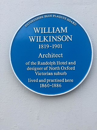
William Wilkinson (1819–1901) was a British Gothic Revival architect who practised in Oxford, England.

<span class="mw-page-title-main">Timeline of Oxford</span> Timeline of English town

The following is a timeline of the history of the city, University and colleges of Oxford, England.

<span class="mw-page-title-main">Thomas Rayson</span>

Thomas Rayson was an architect who practised in Oxford, England, and also a watercolourist.

<span class="mw-page-title-main">Holywell Music Room</span> Chamber music hall in Oxford, England

The Holywell Music Room is the city of Oxford's chamber music hall, situated on Holywell Street in the city centre, and is part of Wadham College. It is said to be the oldest purpose-built music room in Europe, and hence Britain's first concert hall.

References

  1. Jenkins, Stephanie. "Broad Street". Oxford History.
  2. Sherwood & Pevsner 1974, pp. 312–313.
  3. Sherwood & Pevsner 1974, p. 71.
  4. 1 2 Tyack 1998, p. 22.
  5. Sherwood & Pevsner 1974, p. 263.
  6. 1 2 Jenkins, Stephanie. "Landmarks in the History of Broad Street". Oxford History. Retrieved 3 August 2012.
  7. Tyack 1998, p. 3.
  8. Historic England. "The White Horse public house (Grade II) (1185470)". National Heritage List for England . Retrieved 29 March 2018.
  9. Historic England. "Bastion 4 Bastion Number 4 (Grade I) (1184408)". National Heritage List for England . Retrieved 29 March 2018.
  10. Hudson 2012, p. 7.
  11. Graham 1973, 2. His character.
  12. "Discover Blackwell's: The History and Heritage of an Oxford Family Bookshop". Blackwell's . Retrieved 12 January 2023.
  13. "No. 29: Former Octagonal Chapel". Broad Street, Oxford. UK: Oxford History. Retrieved 12 January 2023.
  14. "Cecil Jackson-Cole (1901–1979)". Oxfordshire Blue Plaques Scheme. Oxfordshire Blue Plaques Board . Retrieved 29 March 2018.

Bibliography

51°45′16″N1°15′24″W / 51.75444°N 1.25667°W / 51.75444; -1.25667