Brookfield, Vermont

Last updated

Brookfield, Vermont
Town
BrookfieldVT OldTownHall.jpg
Brookfield Old Town Hall
Brookfield vt highlight.png
Located in Orange County, Vermont
Usa edcp location map.svg
Red pog.svg
Brookfield, Vermont
Location within the U.S.A.
Coordinates: 44°1′25″N72°36′0″W / 44.02361°N 72.60000°W / 44.02361; -72.60000
Country United States
State Vermont
County Orange
Chartered1781
Settled1779
Organized1785
Communities Brookfield
Brookfield Center
East Brookfield
West Brookfield
Area
  Total41.7 sq mi (107.9 km2)
  Land41.4 sq mi (107.2 km2)
  Water0.3 sq mi (0.7 km2)
Elevation
1,325 ft (333 m)
Population
 (2020)
  Total1,244
  Density30/sq mi (11.6/km2)
  Households
475
  Families
351
Time zone UTC-5 (EST)
  Summer (DST) UTC-4 (EDT)
ZIP code
05036
Area code 802
FIPS code 50-09325 [1]
GNIS feature ID1462054 [2]
Website brookfieldvt.org

Brookfield is a town in Orange County, Vermont, United States. It was created by Vermont charter on August 5, 1781. The population was 1,244 at the 2020 census. [3] Brookfield is best known for its floating bridge which spans Sunset Lake buoyed by pontoons. The bridge, which is the only floating bridge east of the Mississippi River, was originally built in 1820 by Luther Adams and his neighbors. Sunset Lake is also the site of an annual ice harvesting festival. Brookfield boasts that it has Vermont's oldest continually operating library dating back to 1791. In 2006, Brookfield was one of the first American towns to have its citizens pass a resolution endorsing the impeachment of President George W. Bush. As of September 2010, the floating bridge was closed for repairs. Work began in 2014, and was completed May 2015. There was a celebration from May 23–24, 2015, to memorialize the event. Governor Peter Shumlin attended, and cadets from Norwich University provided traffic control.

Contents

The town's modest village center is listed on the National Register of Historic Places as the Brookfield Village Historic District.

Geography

According to the United States Census Bureau, the town has a total area of 41.7 square miles (107.9 km2), of which 41.4 square miles (107.2 km2) is land and 0.3 square mile (0.7 km2) (0.65%) is water.

Demographics

Historical population
CensusPop.Note
1790 419
1800 988135.8%
1810 1,38440.1%
1820 1,5078.9%
1830 1,67711.3%
1840 1,7896.7%
1850 1,672−6.5%
1860 1,521−9.0%
1870 1,269−16.6%
1880 1,239−2.4%
1890 996−19.6%
1900 9960.0%
1910 1,0081.2%
1920 860−14.7%
1930 761−11.5%
1940 8086.2%
1950 762−5.7%
1960 597−21.7%
1970 6061.5%
1980 95958.3%
1990 1,08913.6%
2000 1,22212.2%
2010 1,2925.7%
2020 1,244−3.7%
U.S. Decennial Census [4]

As of the census [1] of 2000, there were 1,222 people, 475 households, and 351 families residing in the town. The population density was 29.5 people per square mile (11.4/km2). There were 602 housing units at an average density of 14.5 per square mile (5.6/km2). The racial makeup of the town was 97.63% White, 0.16% African American, 0.16% Native American, 0.98% Asian, and 1.06% from two or more races. Hispanic or Latino of any race were 0.08% of the population.

There were 475 households, out of which 32.2% had children under the age of 18 living with them, 61.3% were married couples living together, 9.1% had a female householder with no husband present, and 26.1% were non-families. 17.9% of all households were made up of individuals, and 6.9% had someone living alone who was 65 years of age or older. The average household size was 2.57 and the average family size was 2.87.

In the town, the population was spread out, with 25.1% under the age of 18, 5.6% from 18 to 24, 27.9% from 25 to 44, 30.0% from 45 to 64, and 11.4% who were 65 years of age or older. The median age was 40 years. For every 100 females, there were 100.7 males. For every 100 females age 18 and over, there were 96.4 males.

The median income for a household in the town was $45,515, and the median income for a family was $51,071. Males had a median income of $34,464 versus $24,258 for females. The per capita income for the town was $21,502. About 2.5% of families and 6.1% of the population were below the poverty line, including 6.9% of those under age 18 and 5.3% of those age 65 or over.

Notable people

Related Research Articles

<span class="mw-page-title-main">Orange County, Vermont</span> County in Vermont, United States

Orange County is a county located in the U.S. state of Vermont. As of the 2020 census, the population was 29,277. Its shire town is the town of Chelsea. Orange County was organized on February 2, 1781, as an original county within the state.

Brookfield is a town in Madison County, New York, United States. The population was 2,403 at the 2000 census.

<span class="mw-page-title-main">Wheelock, Vermont</span> Town in Vermont, United States

Wheelock is a town in Caledonia County, Vermont, United States. The population was 759 at the 2020 census.

<span class="mw-page-title-main">Bloomfield, Vermont</span> Town in Vermont, United States

Bloomfield is a town in Essex County, Vermont, United States. The population was 217 at the 2020 census. It is part of the Berlin, NH–VT Micropolitan Statistical Area.

<span class="mw-page-title-main">Lemington, Vermont</span> Town in Vermont, United States

Lemington is a town in Essex County, Vermont, United States. The population was 87 as of the 2020 census. It is part of the Berlin, NH–VT Micropolitan Statistical Area.

<span class="mw-page-title-main">Lunenburg, Vermont</span> Town in Vermont, United States

Lunenburg is a town in Essex County, Vermont, United States. The population was 1,246 at the 2020 census, the most populous in Essex County. Lunenburg contains the villages of West Lunenburg, South Lunenburg, Mill Village and Gilman, and is part of the Berlin, NH–VT Micropolitan Statistical Area.

<span class="mw-page-title-main">Richford, Vermont</span> Town in Vermont, United States

Richford is a town in Franklin County, Vermont, United States, located along the Canada–United States border. The population was 2,346 at the 2020 census.

<span class="mw-page-title-main">Wolcott, Vermont</span> Town in Vermont, United States

Wolcott is a town in Lamoille County, Vermont, United States. The town was named for General Oliver Wolcott, a signer of the Declaration of Independence. The population was 1,670 at the 2020 census.

<span class="mw-page-title-main">Braintree, Vermont</span> Town in Vermont, United States

Braintree is a town in Orange County, Vermont, United States created by Vermont charter on August 1, 1781. The population was 1,207 at the 2020 census. Braintree includes the places Braintree Center, Braintree Hill, East Braintree, West Braintree, Peth and Snowsville.

<span class="mw-page-title-main">Fairlee, Vermont</span> Town in Vermont, United States

Fairlee is a town in Orange County, Vermont, United States. The population was 988 at the 2020 census. It includes the village of Ely. Fairlee is home to Lake Morey, which claims to have the longest ice skating trail in the United States.

<span class="mw-page-title-main">Orange, Vermont</span> Town in Vermont, United States

Orange is a town in Orange County, Vermont, United States. The population was 1,048 at the 2020 census.

<span class="mw-page-title-main">Randolph, Vermont</span> Town in Vermont, United States

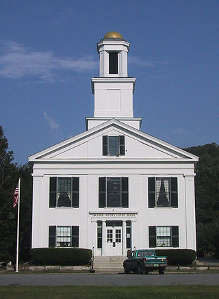
Randolph is a town in Orange County, Vermont, United States. The population was 4,774 at the 2020 census, making Randolph the largest town in Orange County. The town is a commercial center for many of the smaller, rural farming communities that surround it.

<span class="mw-page-title-main">Strafford, Vermont</span> Town in Vermont, United States

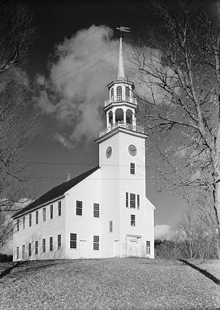
Strafford is a town in Orange County, Vermont, United States. The population was 1,094 at the 2020 census. The town of Strafford was created on August 12, 1761 by way of a royal charter which King George III of Great Britain issued to Governor Benning Wentworth of New Hampshire. The town was named after the Earl of Strafford. Its town house is one of the most famous in Vermont, sitting atop a hill in the historic town square.

<span class="mw-page-title-main">Topsham, Vermont</span> Town in Vermont, United States

Topsham is a town in Orange County, Vermont, United States. The population was 1,199 at the 2020 census. It contains four villages: East Topsham, Topsham Four Corners, Waits River, and West Topsham.

<span class="mw-page-title-main">Vershire, Vermont</span> Town in Vermont, United States

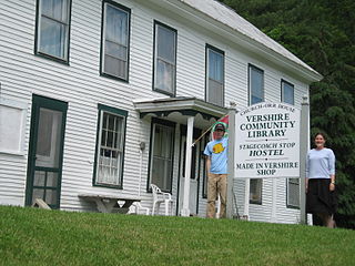
Vershire is a town in Orange County, Vermont, United States, created under Vermont Charter of August 3, 1781. The population was 672 at the 2020 census. The name Vershire is a portmanteau of Vermont and New Hampshire.

<span class="mw-page-title-main">Williamstown, Vermont</span> Town in Vermont, United States

Williamstown is a town in Orange County, Vermont, United States. The population was 3,515 at the 2020 census, making it the second largest municipality in the county.

<span class="mw-page-title-main">Pittsford, Vermont</span> Town in Vermont, United States

Pittsford is a town in Rutland County, Vermont, United States. As of the 2020 census, the town population was 2,862. Named for William Pitt, it has two picket forts used in the American Revolutionary War.

<span class="mw-page-title-main">Warren, Vermont</span> Town in Vermont, United States

Warren is a town in Washington County, Vermont, United States. The population was 1,977 at the 2020 census. The center of population of Vermont is located in Warren. It is set between the two ranges of the Green Mountains, with approximately 25% of the town under Green Mountain National Forest ownership. Sugarbush Resort located here is a ski resort, and the town is traversed by the Long Trail, a hiking trail running from the border with Massachusetts to the Canada–US border.

<span class="mw-page-title-main">Vermont, Wisconsin</span> Town in Wisconsin, United States

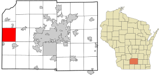
Vermont is a town located in Dane County, Wisconsin, United States. The population was 871 at the 2020 Census. The unincorporated communities of Elvers and Vermont are located in the town.

<span class="mw-page-title-main">Cambridge, Vermont</span> Town in Vermont, United States

Cambridge is a town in Lamoille County, Vermont, United States. The population was 3,839 at the 2020 United States Census. Cambridge includes the villages of Jeffersonville and Cambridge.

References

  1. 1 2 "U.S. Census website". United States Census Bureau . Retrieved January 31, 2008.
  2. "US Board on Geographic Names". United States Geological Survey. October 25, 2007. Retrieved January 31, 2008.
  3. "Census - Geography Profile: Brookfield town, Orange County, Vermont" . Retrieved December 28, 2021.
  4. "U.S. Decennial Census". United States Census Bureau. Retrieved May 16, 2015.
  5. 1 2 Freese, Alicia (November 30, 2016). "In With the New: Two College-to-Statehouse Reps Prepare to Serve". Seven Days. Burlington, VT.
  6. Gomide, Jonathan (2020). Morse, George Washington (1816–1909) (PDF). Silver Spring , MD: General Conference of Seventh-day Adventists. p. 1.
  7. Carleton, Hiram (1903). Genealogical and Family History of the State of Vermont. New York, NY: Lewis Publishing Company. p. 272 via Google Books.
  8. "Myron W. Reed is Dead," Chicago Chronicle, Jan. 31, 1899, unspecified page. Copy preserved in The Papers of Eugene V. Debs, 1834-1945 microfilm edition, reel 9.