Calera, Alabama

Last updated

Calera
Calera, Alabama
Calera Alabama Feb 2012 01.jpg
The Calera Downtown Historic District was listed on the National Register of Historic Places on March 29, 2006.
Chilton County and Shelby County Alabama Incorporated and Unincorporated areas Calera Highlighted 0111416.svg
Location of Calera in Chilton County and Shelby County, Alabama.
Usa edcp location map.svg
Red pog.svg
Calera
Location in the United States
Coordinates: 33°06′10″N86°45′13″W / 33.10278°N 86.75361°W / 33.10278; -86.75361
Country United States
State Alabama
Counties Chilton, Shelby
Government
  MayorJon G. Graham
Area
[1]
  Total24.47 sq mi (63.38 km2)
  Land24.21 sq mi (62.70 km2)
  Water0.26 sq mi (0.68 km2)
Elevation
[2]
558 ft (170 m)
Population
 (2020)
  Total16,494
  Density681.32/sq mi (263.05/km2)
Time zone UTC-6 (CST)
  Summer (DST) UTC-5 (CDT)
ZIP code
35040 [3]
Area code(s) 205, 659
FIPS code 01-11416
GNIS feature ID2403965 [2]
Website www.cityofcalera.org

Calera is a city in Shelby and Chilton counties in the U.S. state of Alabama. It is the location of the Shelby County Airport.

Contents

As of the 2010 census Calera had a population of 11,620, more than tripling its total in 2000, [4] making it the fastest-growing city in Alabama. It is within the Birmingham, Alabama Metropolitan Statistical Area.

Geography

Calera is located in southern Shelby County and the city limits extend southward into Chilton County along U.S. Route 31, the main highway through the city. Interstate 65 passes through the eastern side of the city, with access from exits 228, 231, and 234. Birmingham is 34 mi (55 km) north, and Montgomery is 59 mi (95 km) south, both via I-65.

According to the United States Census Bureau, the city has a total area of 24.4 square miles (63.1 km2), of which 24.1 square miles (62.4 km2) is land and 0.27 square miles (0.7 km2), or 1.17%, is water. [4]

History

Calera in 1935 Alabama - Claera through Florence - NARA - 23933391 (cropped).jpg
Calera in 1935

The city of Calera was incorporated in 1887, and named after the Spanish word for "quarry" for all of the limestone deposits located in the area.[ citation needed ]

Demographics

Historical population
CensusPop.Note
1880 234
1890 753221.8%
1900 7702.3%
1910 754−2.1%
1920 85213.0%
1930 97514.4%
1940 1,09212.0%
1950 1,36124.6%
1960 1,92841.7%
1970 1,655−14.2%
1980 2,03523.0%
1990 2,1365.0%
2000 3,15847.8%
2010 11,620268.0%
2020 16,49441.9%
U.S. Decennial Census [5]

2000 census

As of the census [6] of 2000, there were 3,158 people, 1,248 households, and 888 families living in the city. The population density was 244.9 inhabitants per square mile (94.6/km2). There were 1,400 housing units at an average density of 108.6 per square mile (41.9/km2). The racial makeup of the city was 77.42% White, 19.92% Black or African American, 0.19% Native American, 0.54% Asian, 0.06% Pacific Islander, 0.66% from other races, and 1.20% from two or more races. 1.90% of the population were Hispanic or Latino of any race.

Of the 1,248 households 33.0% had children under the age of 18 living with them, 54.1% were married couples living together, 13.5% had a female householder with no husband present, and 28.8% were non-families. 26.4% of households were one person and 10.8% were one person aged 65 or older. The average household size was 2.51 and the average family size was 3.04.

The age distribution was 26.7% under the age of 18, 8.2% from 18 to 24, 31.7% from 25 to 44, 20.9% from 45 to 64, and 12.5% 65 or older. The median age was 34 years. For every 100 females, there were 93.0 males. For every 100 females age 18 and over, there were 85.0 males.

The median household income was $35,650 and the median family income was $42,885. Males had a median income of $34,042 versus $21,750 for females. The per capita income for the city was $16,395. About 12.2% of families and 12.5% of the population were below the poverty line, including 15.8% of those under age 18 and 3.2% of those age 65 or over.

2010 census

As of the census [7] of 2010, there were 11,620 people, 4,657 households, and 3,240 families living in the city. The population density was 482.2 inhabitants per square mile (186.2/km2). There were 5,128 housing units at an average density of 212.8 per square mile (82.2/km2). The racial makeup of the city was 71.2% White, 23.0% Black or African American, 0.2% Native American, 0.6% Asian, 0% Pacific Islander, 2.9% from other races, and 2.0% from two or more races. 5.0% of the population were Hispanic or Latino of any race.

Of the 4,657 households 35.4% had children under the age of 18 living with them, 53.8% were married couples living together, 12.3% had a female householder with no husband present, and 30.4% were non-families. 25.9% of households were one person and 5.2% were one person aged 65 or older. The average household size was 2.49 and the average family size was 3.01.

The age distribution was 26.5% under the age of 18, 7.4% from 18 to 24, 39.5% from 25 to 44, 18.5% from 45 to 64, and 8.0% 65 or older. The median age was 31.9 years. For every 100 females, there were 92.0 males. For every 100 females age 18 and over, there were 87.7 males.

The median household income was $54,080 and the median family income was $62,117. Males had a median income of $47,125 versus $37,888 for females. The per capita income for the city was $24,391. About 9.6% of families and 12.6% of the population were below the poverty line, including 18.9% of those under age 18 and 7.8% of those age 65 or over.

2020 census

Calera racial composition [8]
RaceNum.Perc.
White (non-Hispanic)9,26456.17%
Black or African American (non-Hispanic)5,20531.56%
Native American 310.19%
Asian 1340.81%
Pacific Islander 30.02%
Other/Mixed 8164.95%
Hispanic or Latino 1,0416.31%

As of the 2020 United States census, there were 16,494 people, 5,100 households, and 3,469 families residing in the city.

Notable people

Points of interest

Climate

The climate in this area is characterized by hot, humid summers and generally mild to cool winters. According to the Köppen Climate Classification system, Calera has a humid subtropical climate, abbreviated "Cfa" on climate maps. Calera is the location of the National Weather Service forecast office that serves the Birmingham metropolitan area. [9] [10]

Climate data for Calera, Alabama
MonthJanFebMarAprMayJunJulAugSepOctNovDecYear
Mean daily maximum °C (°F)12
(54)
16
(60)
19
(67)
25
(77)
28
(83)
32
(89)
33
(92)
33
(91)
30
(86)
25
(77)
19
(66)
14
(58)
24
(75)
Mean daily minimum °C (°F)−1
(31)
1
(33)
5
(41)
9
(48)
13
(55)
17
(63)
19
(67)
19
(66)
16
(61)
9
(48)
4
(39)
1
(33)
9
(49)
Average precipitation mm (inches)130
(5.1)
130
(5.3)
170
(6.5)
130
(5.2)
100
(4)
110
(4.2)
140
(5.4)
110
(4.2)
97
(3.8)
71
(2.8)
94
(3.7)
130
(5.1)
1,400
(55.1)
Source: Weatherbase [11]

Related Research Articles

<span class="mw-page-title-main">Shelby County, Alabama</span> County in Alabama, United States

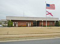
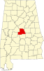
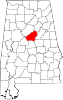
Shelby County is located in the central portion of the U.S. state of Alabama. As of the 2020 census the population was 223,024, making it the sixth-most populous county in Alabama. The county seat is Columbiana. Its largest city is Alabaster. The county is named in honor of Isaac Shelby, Governor of Kentucky from 1792 to 1796 and again from 1812 to 1816. Shelby County is included in the Birmingham–Hoover, AL Metropolitan Statistical Area.

<span class="mw-page-title-main">Brent, Alabama</span> City in Alabama, United States

Brent is a city in Bibb County, Alabama, United States. At the 2020 census, the population was 2,972.

<span class="mw-page-title-main">Clayhatchee, Alabama</span> Town in Alabama, United States

Clayhatchee is a town in Dale County, Alabama, United States. At the 2010 census the population was 589, up from 501 in 2000. It was incorporated in April 1967. It is part of the Ozark Micropolitan Statistical Area.

<span class="mw-page-title-main">Boaz, Alabama</span> City in Alabama, United States

Boaz is a city in Marshall and Etowah counties in the U.S. state of Alabama. The Marshall County portion of the city is part of the Albertville Micropolitan Statistical Area. As of the 2020 census, the city's population was 10,107. Boaz was known for its outlet shops.

<span class="mw-page-title-main">Fayette, Alabama</span> City in and county seat of Fayette County, Alabama

Fayette is a city and the county seat of Fayette County, Alabama, United States. The population was 4,619 at the 2010 census, down from 4,922 at the 2000 census.

<span class="mw-page-title-main">Tarrant, Alabama</span> City in Alabama, United States

Tarrant is a city in Jefferson County, Alabama, bordering Birmingham to the north. At the 2020 census, the population was 6,124. It is home to the ABC Coke plant owned by the Drummond Company, "the largest single producer of foundry coke in the U.S.".

<span class="mw-page-title-main">Alabaster, Alabama</span> City in Alabama, United States

Alabaster is a city and southern suburb of Birmingham in Shelby County, Alabama, United States. At the 2020 census, the population was 33,284. Alabaster is the 16th largest city in Alabama by number of residents.

<span class="mw-page-title-main">Columbiana, Alabama</span> City in and county seat of Shelby County, Alabama

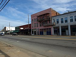
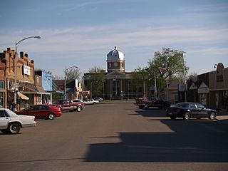
Columbiana is a city and the county seat of Shelby County, Alabama, United States. At the 2020 census, the population was 4,462.

<span class="mw-page-title-main">Wilsonville, Alabama</span> Town in Alabama, United States

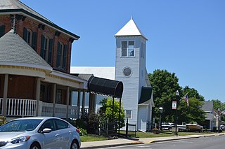
Wilsonville is a town in southeastern Shelby County, Alabama, United States, located northeast of Columbiana. At the 2020 census, the population was 1,857. Wilsonville is named after the earliest settler in the area, Elisha Wilson.

<span class="mw-page-title-main">Wilton, Alabama</span> Town in Alabama, United States

Wilton, also known by the previous names of Birmingham Junction, Bismark, and Catoosa, is a town in Shelby County, Alabama, United States. It was incorporated in 1918. This town is part of the Birmingham–Hoover–Cullman Combined Statistical Area. At the 2010 census the population was 687, up from 580 in 2000.

<span class="mw-page-title-main">Margaret, Alabama</span> City in Alabama, United States

Margaret is a city in St. Clair County, Alabama, United States. At the 2020 census, the population was 5,106. As of the 2010 census, the population is 4,428, an increase of 278.8%. Margaret incorporated in 1960 and became a city in October 2011.

<span class="mw-page-title-main">Shelbyville, Indiana</span> City in Indiana, United States

Shelbyville is a city in Addison Township, Shelby County, in the U.S. state of Indiana and is the county seat. The population was 20,067 as of the 2020 census.

<span class="mw-page-title-main">McCune, Kansas</span> City in Crawford County, Kansas

McCune is a city in Crawford County, Kansas, United States. As of the 2020 census, the population of the city was 370.

<span class="mw-page-title-main">Mound City, Kansas</span> City and County seat in Kansas, United States

Mound City is a city in and the county seat of Linn County, Kansas, United States. As of the 2020 census, the population of the city was 647.

<span class="mw-page-title-main">Ogden, Kansas</span> City in Riley County, Kansas

Ogden is a city in Riley County, Kansas, United States. As of the 2020 census, the population of the city was 1,661. It is located near Fort Riley between Manhattan and Junction City.

<span class="mw-page-title-main">Paris, Missouri</span> City in Missouri, United States

Paris is a city and county seat of Monroe County, Missouri, United States. The population was 1,161 at the 2020 census.

<span class="mw-page-title-main">Bowman, North Dakota</span> City in North Dakota, United States

Bowman is a city and county seat of Bowman County, North Dakota, United States. The population was 1,470 at the 2020 census.

<span class="mw-page-title-main">Crosby, North Dakota</span> City in North Dakota

Crosby is a city and the county seat of Divide County, North Dakota, United States. The population was 1,065 at the 2020 census.

<span class="mw-page-title-main">Jackson Center, Ohio</span> Village in Ohio, United States

Jackson Center is a village in Shelby County, Ohio, United States. The population was 1,441 at the 2020 census.

<span class="mw-page-title-main">Lebo, Kansas</span> City in Coffey County, Kansas

Lebo is a city in Coffey County, Kansas, United States. As of the 2020 census, the population of the city was 885.

References

  1. "2020 U.S. Gazetteer Files". United States Census Bureau. Retrieved October 29, 2021.
  2. 1 2 U.S. Geological Survey Geographic Names Information System: Calera, Alabama
  3. "Zipdatamaps" . Retrieved October 30, 2016.
  4. 1 2 "Geographic Identifiers: 2010 Demographic Profile Data (G001): Calera city, Alabama". U.S. Census Bureau, American Factfinder. Archived from the original on February 12, 2020. Retrieved June 3, 2014.
  5. "Census of Population and Housing". Census.gov. Retrieved June 4, 2016.
  6. "U.S. Census website". United States Census Bureau . Retrieved January 31, 2008.
  7. "U.S. Census website". United States Census Bureau . Retrieved August 8, 2015.
  8. "Explore Census Data". data.census.gov. Retrieved December 11, 2021.
  9. "NWS Birmingham, Alabama". June 20, 2020.
  10. Climate Summary for Calera, Alabama
  11. "Weatherbase.com". Weatherbase. 2013. Retrieved on November 6, 2013.