Camden, Indiana

Last updated

Camden, Indiana
Main Street, Camden, Indiana.png
Looking west along Main Street in Camden
Carroll County Indiana Incorporated and Unincorporated areas Camden Highlighted 1809910.svg
Location of Camden in Carroll County, Indiana.
Coordinates: 40°36′36″N86°32′22″W / 40.61000°N 86.53944°W / 40.61000; -86.53944
Country United States
State Indiana
County Carroll
Township Jackson
Area
[1]
  Total0.26 sq mi (0.67 km2)
  Land0.26 sq mi (0.67 km2)
  Water0.00 sq mi (0.00 km2)
Elevation
[2]
676 ft (206 m)
Population
 (2020)
  Total593
  Density2,289.58/sq mi (884.65/km2)
Time zone UTC−5 (EST)
  Summer (DST) UTC−5 (EST)
ZIP code
46917
Area code 574
FIPS code 18-09910 [3]
GNIS feature ID2396624 [2]
Website http://www.townofcamden.org

Camden is a town in Jackson Township, Carroll County, Indiana, United States. The population was 611 at the 2010 census. It is part of the Lafayette, Indiana Metropolitan Statistical Area.

Contents

History

The former Andrew Thomas House and historical marker on West Main Street is now the Jackson Township Public Library and Museum. Camden, Indiana library.png
The former Andrew Thomas House and historical marker on West Main Street is now the Jackson Township Public Library and Museum.

The post office at Camden was established in 1833. [4] Camden was platted as a town in 1836. [5]

The Camden Masonic Temple, New 1952 Camden High School Gymnasium and Andrew Thomas House are listed on the National Register of Historic Places. [6]

Geography

Camden is located in Jackson Township.

According to the 2010 census, Camden has a total area of 0.26 square miles (0.67 km2), all land. [7]

Demographics

Historical population
CensusPop.Note
1850 168
1860 31688.1%
1870 47650.6%
1880 457−4.0%
1910 557
1920 5977.2%
1930 538−9.9%
1940 5909.7%
1950 6001.7%
1960 6010.2%
1970 577−4.0%
1980 6187.1%
1990 607−1.8%
2000 582−4.1%
2010 6115.0%
2020 593−2.9%
U.S. Decennial Census [8]

2010 census

As of the census [9] of 2010, there were 611 people, 249 households, and 161 families living in the town. The population density was 2,350.0 inhabitants per square mile (907.3/km2). There were 271 housing units at an average density of 1,042.3 per square mile (402.4/km2). The racial makeup of the town was 98.2% White, 0.3% African American, 0.2% Native American, and 1.3% from two or more races.

There were 249 households, of which 31.3% had children under the age of 18 living with them, 50.2% were married couples living together, 8.8% had a female householder with no husband present, 5.6% had a male householder with no wife present, and 35.3% were non-families. 32.9% of all households were made up of individuals, and 19.7% had someone living alone who was 65 years of age or older. The average household size was 2.45 and the average family size was 3.04.

The median age in the town was 40.2 years. 25.2% of residents were under the age of 18; 7% were between the ages of 18 and 24; 23.3% were from 25 to 44; 26.7% were from 45 to 64; and 17.8% were 65 years of age or older. The gender makeup of the town was 47.6% male and 52.4% female.

2000 census

As of the census [3] of 2000, there were 582 people, 233 households, and 160 families living in the town. The population density was 2,240.7 inhabitants per square mile (865.1/km2). There were 248 housing units at an average density of 954.8 per square mile (368.7/km2). The racial makeup of the town was 98.97% White, 0.69% Native American, and 0.34% from two or more races.

There were 233 households, out of which 34.8% had children under the age of 18 living with them, 59.7% were married couples living together, 6.0% had a female householder with no husband present, and 31.3% were non-families. 28.3% of all households were made up of individuals, and 18.5% had someone living alone who was 65 years of age or older. The average household size was 2.50 and the average family size was 3.10.

In the town, the population was spread out, with 27.8% under the age of 18, 5.8% from 18 to 24, 29.0% from 25 to 44, 19.2% from 45 to 64, and 18.0% who were 65 years of age or older. The median age was 36 years. For every 100 females, there were 90.2 males. For every 100 females age 18 and over, there were 82.6 males.

The median income for a household in the town was $44,250, and the median income for a family was $53,750. Males had a median income of $30,083 versus $22,174 for females. The per capita income for the town was $19,476. About 1.3% of families and 4.2% of the population were below the poverty line, including none of those under age 18 and 21.2% of those age 65 or over.

Education

The town has a free lending library, the Camden-Jackson Township Public Library. [10]

Plain community

The Old Brethren German Baptists, a small Christian Old Order horse and buggy community, that many erroneously perceive as Amish, has its center near Camden.

Notable people

Related Research Articles

<span class="mw-page-title-main">Burlington, Indiana</span> Town in Indiana, United States

Burlington is a town in Burlington Township, Carroll County, Indiana, United States. The population was 603 at the 2010 census. It is part of the Lafayette, Indiana Metropolitan Statistical Area. State Road 22 connects it to Kokomo.

<span class="mw-page-title-main">Flora, Indiana</span> Town in Indiana, United States

Flora is a town in Monroe Township, Carroll County, Indiana, United States. The population was 2,036 at the 2010 census. It is part of the Lafayette, Indiana Metropolitan Statistical Area.

<span class="mw-page-title-main">Yeoman, Indiana</span> Town in Indiana, United States

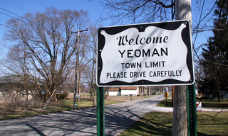
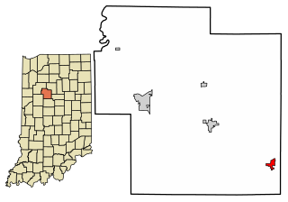
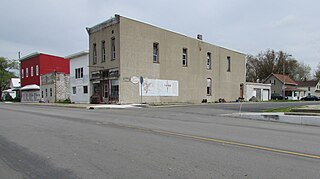
Yeoman is a town in Jefferson Township, Carroll County, Indiana, United States. The population was 139 at the 2010 census. It is part of the Lafayette, Indiana Metropolitan Statistical Area.

<span class="mw-page-title-main">St. Leon, Indiana</span> Town in Indiana, United States

St. Leon or Saint Leon is a town in Kelso Township, Dearborn County, Indiana, United States. The population was 678 at the 2010 census.

<span class="mw-page-title-main">West Harrison, Indiana</span> Town in Indiana, United States

West Harrison is a town in Harrison Township, Dearborn County, Indiana, United States. The population was 289 at the 2010 census.

<span class="mw-page-title-main">St. Paul, Indiana</span> Town in Indiana, United States

St. Paul or Saint Paul is a small town on the border of Decatur and Shelby counties in the U.S. state of Indiana. The population was 1,031 at the 2010 census.

<span class="mw-page-title-main">Ashley, Indiana</span> Town in Indiana, United States

Ashley is a town in Indiana located on the border of Smithfield Township, DeKalb County and Steuben Township, Steuben County. The population was 983 at the 2010 census.

<span class="mw-page-title-main">Wilkinson, Indiana</span> Town in Indiana, United States

Wilkinson is a town in Brown Township, Hancock County, Indiana, United States. The population was 449 at the 2010 census.

<span class="mw-page-title-main">Andrews, Indiana</span> Town in Indiana, United States

Andrews is a town in Dallas Township, Huntington County, Indiana, United States. The population was 1,048 at the 2020 census.

<span class="mw-page-title-main">Sidney, Indiana</span> Town in Indiana, United States

Sidney is a town in Jackson Township, Kosciusko County, in the U.S. state of Indiana. The population was 83 at the 2010 census.

<span class="mw-page-title-main">Edgewood, Indiana</span> Town in Indiana, United States

Edgewood is a town in Anderson Township, Madison County, Indiana, United States. It is part of the Indianapolis–Carmel–Anderson metropolitan statistical area. The population was 2,053 at the 2020 census.

<span class="mw-page-title-main">Woodlawn Heights, Indiana</span> Town in Indiana, United States

Woodlawn Heights is a town in Anderson Township, Madison County, Indiana, United States. It is part of the Indianapolis–Carmel–Anderson metropolitan statistical area. The population was 91 at the 2020 census.

<span class="mw-page-title-main">Bethany, Indiana</span> Town in Indiana, United States

Bethany is a town in Clay Township, Morgan County, in the U.S. state of Indiana. The population was 95 at the 2020 census.

<span class="mw-page-title-main">Paragon, Indiana</span> Town in Indiana, United States

Paragon is a town in Ray Township, Morgan County, in the U.S. state of Indiana. The population was 556 at the 2020 census, down from 659 in 2010.

<span class="mw-page-title-main">Clear Lake, Indiana</span> Town in Indiana, United States

Clear Lake is a town located in the northeast corner of Steuben County, Indiana, in Clear Lake Township. As such, is the northeasternmost community in the State of Indiana. The population was 339 at the 2010 census.

<span class="mw-page-title-main">Mount Auburn, Indiana</span> Town in Indiana, United States

Mount Auburn is a town in Jackson Township, Wayne County, in the U.S. state of Indiana. The population was 117 at the 2010 census. The town is sandwiched between Dublin and Cambridge City.

<span class="mw-page-title-main">Appleton, Maine</span> Town in the state of Maine, United States

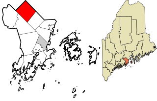
Appleton is a town in Knox County, Maine, United States. It is about 15 miles inland from Penobscot Bay and coastal towns such as Camden and Rockland, about 30 miles east of the state capital of Augusta. The population was 1,411 at the 2020 census.

<span class="mw-page-title-main">Camden, Ohio</span> Village in Ohio, United States

Camden is a village in Preble County, Ohio, United States. The population was 1,989 at the 2020 census.

<span class="mw-page-title-main">Camden-on-Gauley, West Virginia</span> Town in West Virginia, United States

Camden-on-Gauley is a town in Webster County, West Virginia, United States, along the Gauley River. The population was 126 at the 2020 census.

<span class="mw-page-title-main">North Crows Nest, Indiana</span> Town in Indiana, United States

North Crows Nest is a town in Washington Township, Marion County, Indiana, United States. It is approximately 7 miles (11 km) north of downtown Indianapolis. The population was 44 at the 2020 census. It has existed as an "included town" since 1970, when it was incorporated into Indianapolis as part of Unigov. It is part of Indianapolis, but retains town governmental powers under IC 36-3-1-11.

References

  1. "2020 U.S. Gazetteer Files". United States Census Bureau. Retrieved March 16, 2022.
  2. 1 2 U.S. Geological Survey Geographic Names Information System: Camden, Indiana
  3. 1 2 "U.S. Census website". United States Census Bureau . Retrieved January 31, 2008.
  4. "Carroll County". Jim Forte Postal History. Retrieved August 28, 2014.
  5. Odell, John Curtis (1916). History of Carroll County, Indiana: Its People, Industries and Institutions. B.F. Bowen. p. 84.
  6. "National Register Information System". National Register of Historic Places . National Park Service. July 9, 2010.
  7. "G001 - Geographic Identifiers - 2010 Census Summary File 1". United States Census Bureau. Archived from the original on February 13, 2020. Retrieved July 13, 2015.
  8. "Census of Population and Housing". Census.gov. Retrieved June 4, 2015.
  9. "U.S. Census website". United States Census Bureau . Retrieved December 11, 2012.
  10. "Libraries". Carroll County, IN. Archived from the original on March 4, 2018. Retrieved March 4, 2018.